With new plans (or, at least, plans to get a plan) for the Waitematā Harbour crossing in the news, here’s a timely throwback. This post by Matt Lowrie was originally published on 5 June 2019. The more things change, the more they remain the same!
A History of Harbour Crossing Options (first published 5 June 2019)
Talk about an additional harbour crossing has existed for decades. With this post I thought I’d look at some of the many proposals that have existed over the years.
Presumably the first discussions about building a new crossing happened shortly after the existing bridge opened in 1959. I also assume those first discussions ultimately became the clip-ons that were completed in 1969. Following their completion traffic volumes quickly increased and there was certainly discussion about another crossing in the mid-70s. In a series of op-eds in the Herald during 1975, Mayor Sir Dove-Myer Robinson said that a decision on a new bridge or tunnel was urgent, claiming the bridge would reach “maximum carrying capacity” by 1981/82.
Of note, at the time of his writing, the bridge was carrying about 65k vehicles per day, nearly double what it was before the clip-ons opened 6 years earlier. Likely impacted by the oil crises of the 70’s, growth slowed and by 1982 the bridge was carrying 80k per day. Had that growth continued at the same rate as prior to 1975, a 1982 estimate would be more like 100k. Either way, these clearly weren’t maximum capacities as the bridge currently carries about 171k vehicles per day.
I’m not sure if there were any formal investigations to new crossing routes but the first one I have found any records of is from 1988.
1988
The study was for the Auckland Regional Authority and done by the Maunsell (now subsidary of AECOM), Parsons Brinckerhoff and the Ministry of Works and Development. Unfortunately I’ve only got the PT route options but they give a good idea of the thinking at the time. The notes suggest the crossing would have been used by either light rail or a guided busway like Adelaide’s O-Bahn.
There were two route options each for either a bridge or a tunnel. The tunnel would have been an immersed tube, instead of a deep bored tunnel (like Waterview). One option would be just east of the existing bridge and connect to the city through Wynyard, much like current plans, and the other would have cut through the tip of Bayswater and Stanley Point. The tunnel options seem to involve some amount of reclamation for ventilation and presumably to surface the vehicles.
Tunnel options
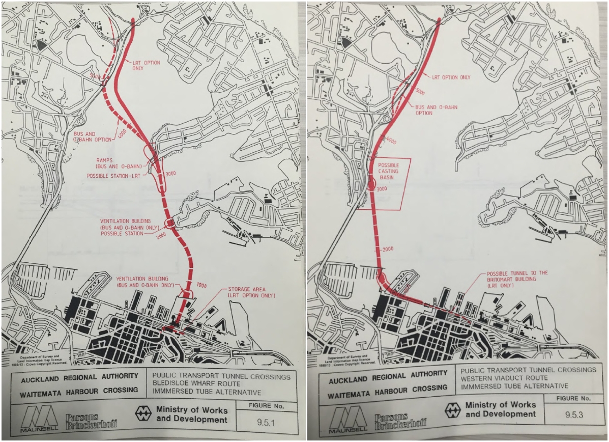
Bridge options

For the bridge option there are also some drawings of what it may have looked like.

1997/98
1997 saw a significant study undertaken for the Auckland Regional Council by Opus.
One thing it notes in its summary is
Traffic forecasts for roading options indicate that the additional cross harbour capacity provided by a four lane crossing is likely to be fully utilized not long after the year 2021.
The study looked at 14 different corridors comprising of 48 options bridge and tunnel options before narrowing down to a shortlist. Some of these were real doozies and would have had monstrous impacts on the city centre. Many were also aligned to connect to the now defunct Eastern Corridor.
All Bridge Options

All Tunnel Options

Shortlist Options
After further assessment, a shortlist of options was created. These are shown below with tunnels as dashed lines

A summary of the assessment of those options is below. As a guide to the listed cost, The RBNZ’s inflation calculator says that $100 million in 1997 is worth about $153 million now. That would put even the most expensive of the options, a tunnel from Esmonde Rd to Judges Bay, at about $2.6 billion.

You may notice mention of two public transport options which would hook into the future Northern Busway.
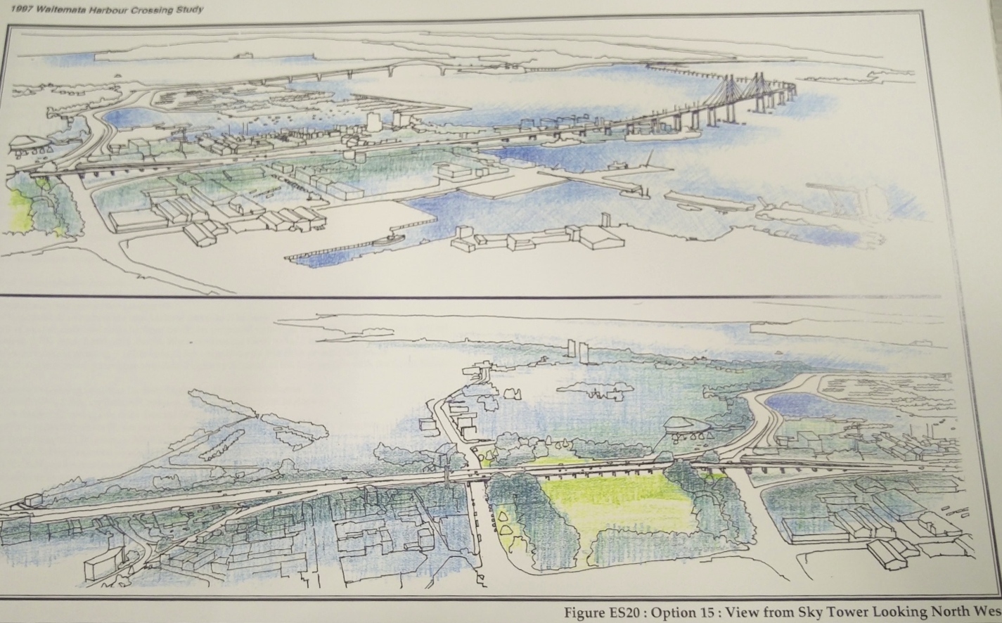
Like with the 1988 report, there are a few drawings of what some of the options would look like. The most notable are:
Option 3.1 carving across Devonport, having already crossed Bayswater.

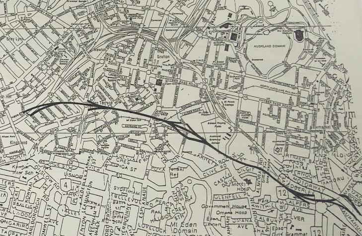
Option 15 which would have put a motorway down Wynyard Point, the western side of Wynyard Quarter and a new viaduct through Victoria Park
What is not shown in this image but you can see on the map above is that route 15 also includes this above-ground route straight though Auckland Grammar.
In 1998 the options went out for public consultation and following the feedback it was decided the next crossing “would be situated in the vicinity of the present harbour bridge“. Also that whether a bridge or tunnel across the harbour, the crossing would connect directly to the Northwestern Motorway via a tunnel through Ponsonby.
2003
Following the study above, in 2003 Transit NZ (predecessor to the NZTA) undertook another study confirm the options that would be meet the outcomes decided from the 1997/98 study. You can see the document on the wayback machine but unfortunately the graphics are low quality.

A preferred option for a bridge and tunnel scheme where selected. No definite cost was given for the options but it does note that any option would likely cost more than $3 billion ($4.3 in 2019).
The preferred tunnel would have been an immersed tube following the dotted line and connecting to the CMJ. It would not have had the tunnel connection to the Northwestern as would use the above ground connections that have since been built.
The preferred bridge option would see the motorway cut under Northcote Point leading to a bridge 500m west of the existing bridge before connecting back around Pt Erin where the route would dive into a bored tunnel under Ponsonby. An artists impression of the bridge of which is below.

For those interested, the document includes some smaller images of the bridge options for either side of the existing bridge showing some very utilitarian structures.
2008
With the planned redevelopment of Wynyard Quarter it was decided another study was needed to reassess crossing options. This study was primarily undertaken by SKM (since acquired by Jacobs).
Like with the 1997 study, they started with a long list of potential options. This time the number of them had expanded to 159 and included heavy rail linking into Britomart. The image below is a more recent high-level graphical representation of those options – bridges and tunnels on the same alignment were considered separate options.

This was then whittled down to a shortlist of three alignments,each of which had a few variations within them.
This was further refined and Option 2C, using bored tunnels, became the recommended option. A feature of this, that continues in the proposals to this day is that the Harbour Bridge would effectively become one big off-ramp to the western side of the city with the new crossing only being for traffic bypassing the city or heading down Grafton Gully.

2010
The 2008 study lead into a more detailed business case by PWC and various other assessments that took place in 2010. That work estimated a road bridge would cost about $3.9 billion with a Benefit Cost Ratio of 0.6, a road tunnel about $5.9 billion with a BCR of 0.4 and a rail tunnel $1.6 billion (no BCR stated). Given what we’ve seen happen to the costs of other projects since then, most notably the City Rail Link, those costs are likely a lot higher now.
Some of the drawings of the bridge versions of that are below.


2019
Since 2010 work on another crossing has focused on protecting the route but there has been little information in public on just what this entails. We do know that another look at alternative routes, likely similar to what happened in 2008, occurred in 2016 and 2017 as part of the route protection assessments. It was also decided during the Auckland Plan process that a tunnel would be the preferred solution. This has often felt as if it’s more about no one wanting to make a decision on a structure that would so dramatically change the skyline than anything else.
Another change in recent years has been a focus on combining the road and rail tunnels into a single crossing instead of having them separate. At first I think this was more about finding ways to get a quicker and cheaper rail crossing built as the original plan was to repeat the mistakes of the past and build a new road crossing but leave any rail crossing for a separate project.
 But the most recent information released by the NZTA suggests some thinking on the makeup and timing of projects may have flipped. A PT crossing is now accepted as being needed sooner than a road crossing but the highway engineers seem to want to keep the tunnels combined as it likely now the only chance they’ll now get to also get a road crossing. That information came from some new modelling showing that building a road crossing was a waste of money as it undermines Aucklands strategies and actually makes congestion worse. It suggested the best outcome came from building a light rail only crossing.
Sidebar: 2009 – the ANZAC Bridge concept
In 2009 a group of private companies suggested a new bridge to be built by 2015 to commemorate the ANZAC centenary. It would follow a similar alignment to option 2C from 2008. What was interesting about this proposal is they planned it to replace the existing bridge rather than add it as an additional crossing. They would pay for at least part of it through redeveloping the land used by the motorway through St Mary’s Bay and along the eastern edge of Northcote Point south of Onewa Rd – an idea that seemed improbable.


What have we learnt?
Unsurprisingly, the general route concepts that came up 30 years ago are the same ones that come up today, albeit with minor tweaks. This is not surprising, given Auckland’s geography hasn’t changed during that time.
One thing that is clear, though, is discussion about a new crossing has been a great make-work scheme for consultants with major repeats of the same work coming out every decade or so. Since 2013 alone the NZTA has spent about $25 million on investigating another crossing and $55 million on property purchases. I wonder how many more millions have been racked up over the previous decades investigating the idea.
What’s also clear is that predictions about the existing bridge running out of capacity or there being an issue with the clip-ons, thus requiring a new crossing are often woefully inaccurate. Related to this, perhaps the single biggest thing that has reduced the need for another crossing has been the advent of the Northern Busway which has meant a lot more people can cross the bridge at peak times.
I think we’ll hear calls for a new road crossing continue to pop up over the coming decades and we’ll probably see these evaluation processes continue to occur.
– By Matt Lowrie, originally published 5 June 2019
Postscript: A 2026 update
Pretty prophetic post, huh? The latest estimate of consultant spending is more than $106m…. since the 2021/22 financial year!
The Government has now announced a whole new process for evaluating the options, and we have a number of questions about this approach. In particular, we strongly believe more transparency is needed, and that Auckland – and Aucklanders – must be more involved in the process.
Interestingly, the reset apparently includes at least one “market-led proposal”, although it’s unclear as yet what that is.
That’s where we come in. If they’re seriously taking suggestions – and they should be – Greater Auckland has strongly endorsed a proposal that we believe answers the problem case, can actually be built, and would give our city an iconic addition to the skyline that could be enjoyed by people using all modes of travel.
We’ve recently presented this proposal to Council, and we think it should be seriously considered by Government. One way to help make that happen is for the Mayor and Councillors to politically champion this option on behalf of Aucklanders. It also helps if more people know about it, so please feel free to share the Waitematā Bridge concept far and wide.
Read more about the brilliant bridge proposal here, and see the FAQs here.
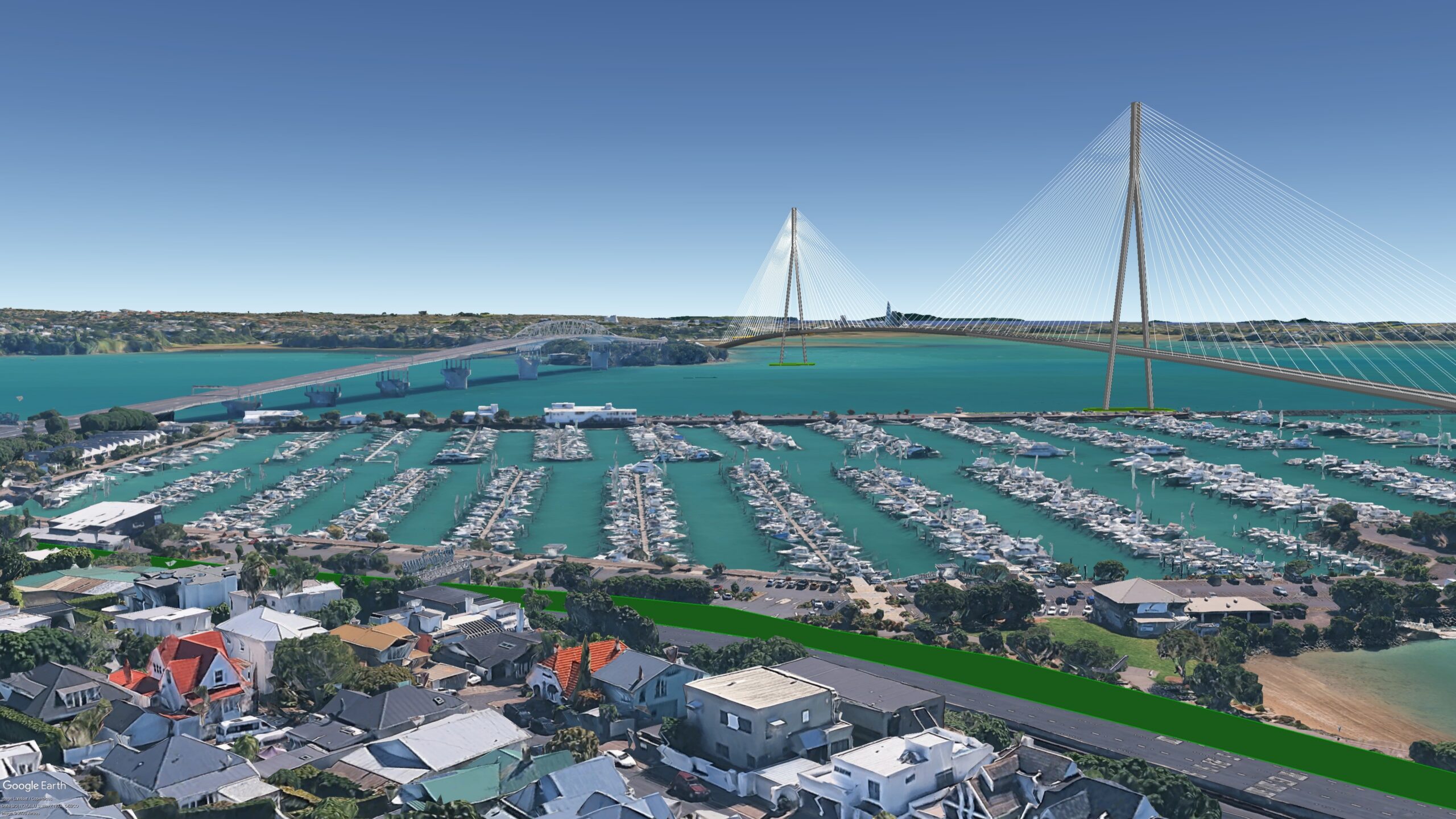
The Waitematā Bridge as proposed by Nicolas Reid and endorsed by Greater Auckland. Read more about it here.
Greater Auckland’s research and advocacy is powered by hundreds of hours of work each month. If you enjoy what we produce and would like to support more of it, we warmly welcome your donations. We are also open to offers of guest posts, practical help, and pro-bono expertise.
Another great way to support the kaupapa is via Greater Auckland merch. Allow a week for delivery – and these are print-on-demand (no returns), so be sure to double-check your sizing before ordering!

 Processing...
So can we say that all that money on consultants was actually well spent, considering it therefore meant that we didn’t beggar ourselves to the tune of a few billions (and a couple hundred mil every year for interest) for a new crossing that may not be needed? Seems a bargain for a few mil a year [Just being cheeky – I’m a consultant myself, though I haven’t worked on any of the above studies.]
MBIE are facing major heat over their failed $33 million biometrics project, meanwhile NZTA blowing another $100 million on a project with no progress to show for it is just another day at the office.
Well, to be fair, I understand that the 100 million are over several decades? And they arguably provided what was asked. If the politicians don’t make any decisions based on the reports and just order another report, I think a lot of that is on the politicians not on bureaucrats and consultants. So people like Winston Peters should be careful who they blame (but of course that is a vain hope).
The $100m it says at the end of the article is in the last 5 years. I don’t believe that’s including the Skypath stuff etc.
Spending money on planning is great. But once it’s getting into the millions it’s an issue, let alone 10 figures (and this is 11 figures).
“MBIE are facing major heat over their failed $33 million biometrics project” – and not keeping the ministers overseeing the department informed.
Seems like ‘we spent $100m’ to produce this render, is fine, as long as you keep the ministers informed. And Simeon when he was transport minister seemed OK, as long as it was more roads and more cars.
I guess the good news is that at least some of that money has been poured into seismic and ground testing around the harbour which is required for any development
Funny thing about renders, is that during Reddit conversations on the topic, AI was able to crank out some very nice pictures very quickly. I wonder now if anybody has tried asking Claude or something what the best solution is
To answer myself…
AI did a surprisingly reasonable job. If I was a consultant, a few hours of prompts, and could churn out a very expensive looking detailed analysis
I got it to use this article as an input and to analyze the history of proposed crossings and to come up with what it thinks is the best answer.
Won’t copy and paste, but recommend trying it with different engines and prompts.
The solution it came up with was:
Proposed Option: Hybrid “Active-Bridge & Rail-Tunnel” Crossing
Can’t really disagree with much is does in summary:
Cost & Footprint: Road tunnels are exorbitantly expensive, while new mega-bridges heavily impact city-centre access and sensitive shorelines (e.g., Wynyard, Devonport, Victoria Park).
Mode Priority: Pure roading capacity quickly hits vehicle limits and worsens traffic, whereas public transport (PT) and active modes deliver high capacity with lower spatial demand.
Constructability & Geology: Crossings via alternative reefs (like Meola Reef) present poor seabed conditions, favoring alignments closer to the existing transport spine.
Bike Aucklands liberate the lane.
https://liberatethelane.nz/
Allocate 1 Lane to walking and cycling.
The only solution that delivers any value to auckland before 2030. Or even 2027.
An interesting ommission to your list of crossing options.
It’s so disappointing ( but not hard to join the dots) that whilst we have political parties on all sides talking about the need to be financially savvy they are beyond reluctant to consider making better use of the space we already have. Another example is the NW Busway- just reallocate lanes!
People waking over the existing bridge assumes that they all live in Birkenhead and work in a boutique located on Ponsonby Road. How many people per day do you predict will walk across the current bridge, especially in winter? If I live in Browns Bay and work in the CBD, how do I get to the bridge to be able to walk over it? Do I hitch-hike?
Sydney gets 5000 people walking across it a day despite not everyone living in Kirribilli or working at a boutique in The Rocks.
Adjust for population difference and its still a healthy number. Now add cyclists, e-scooters and throw in special events.
Maybe the er bus would work for you?
Good call. Also on the list, the 2019 “preferred design” for walking and cycling that Waka Kotahi/ NZTA released, to great fanfare, more or less drawing a line under the long-running citizen-led Skypath design.
Of course *that* solution – a 5m wide cantilevered pathway – then turned out to be not feasible… for engineering reasons, or something, who knows? Full transparency would have been nice, otherwise you’re left wondering if the whole thing was a bait and switch.
https://www.bikeauckland.org.nz/news/nzta-reveals-new-design-for-a-path-across-auckland-harbour-bridge/
As I keep reminding people there was an investigation by the Auckland Harbour Bridge Authority in the early 70s who could see that the newly added “clip on” lanes would soon be nearing capacity. The 58 page report by Freeman Fox and partners was released in 1974, focussed on the Meola Reef to Kauri Point route. Local engineers Tonkin and Taylor drilled 9 test notes and verified that the hard basalt rock of the reef lay on top of many metres of “gloop” (soft marine mud) with minimal bearing strength. Thus rather than simply “piling a bit of dirt” on the reef as Wayne (I am an engineer you know) Brown imagines, it would be necessary to drive deep piles to find support on the Waitemata series bedrock far below. Doable , but not as cheap and easy as the Mayor thinks.
The Mayor thinks that he is an expert on everything. With his proposal where do the approach roads to his Meola Bridge go, and how do they connect to the existing motorways.
Do I take the Meola Bridge from Birkenhead to Pt Chev, then travel on surface streets in order to get to the Southern MWay?
No one ever asks him what happens once the bridge touches land on either side. Where do the cars go?
Browny’s plan seems to be to fill in a causway on top of the reef most of the way across, and only do a bridge at the end bit close to Kauri point.
“Doable , but not as cheap and easy as the Mayor thinks”
Any info on how much?
Surely there are much cheaper options for not doing any major land aquisition or construction for at least the next decade? Until we have at least identified the actual problem/problems with what we have got, and how any proposed solution would fit in with Auckland’s transport needs as a whole.
Rather then commissioning, yet another, comprehensive and expensive consultants report, going over literally the same ground, just to add the pile of reports already done. Another very expensive way to justify not doing anything just yet.
Another debacle on the scale of another Mt Victoria tunnel.
“Surely there are much cheaper options for not doing any major land aquisition or construction for at least the next decade”
Congestion charging during peak hours. Completing bus priority south of the bridge to speed up trips. Busway on the Upper Harbour Highway connecting Constellation (NX) and Westgate (WX). If the impact on traffic is drastic, liberate a lane for active modes and scooters.
You could put another crossing back decades.
You are right. But only if you define the problem as increasing capacity to moving people from North to South across the Waitemata.
However if you have defined the problem as a need to increase vehicle capacity, there remains the needs for lane kilometres and more car parking just about everywhere. And deliberately ignoring emission induced climate change.
or we could make a few , in the scale of it , small teaks to the Northern Busway and increase the capacity 8,000 people per hour (the same as four road lanes of cars)
Replacing all the double deckers on the NX1 and NX2 with bi-articulated buses would increase capacity of those routes by 50-70%
Run more freqent buses
that too, but it would require better bus priority through St Mary’s Bay and across the existing AHB. The choke point with the most North Shore bus routes interlined is ironically where there’s no busway or bus lanes.
This option has not been included in this summary: https://architecturenow.co.nz/articles/reset-wins-international-award-for-waitemata-harbour-crossings-design/
probably because, as a whole that proposal also includes a very far-fetched bridge/causeway from Waterview to the Upper Harbour Bridge
the same benefits could be had by rapid transit along SH16 and SH18 decongesting car traffic + the addition of another lane if needed
Extending the existing heavy rail network northwards towards Orewa via a tunnel under the harbour is a no brainer to me to best grow Auckland into the future. Forget tinkering around with light rail. A combination of feeder buses and heavy rail is working well southwards to Pukekohe and a similar system surely is best northwards.
Northern busway is too steep and too lightly built to handle a heavy rail conversion, a lot of tunnels would be needed and a second east-west CRL would be needed to link into the system. It’s the most expensive option for North Shore rail and I don’t know what the obsession with “keeping it the same type of rail as what we already have” is
Not sure what the point of that is really, widen all through st marys bay just to build a longer bridge to the west, looping back to a tunnel under Northcote point to get back to the east side again. Seems like a good way to build 4km of fill and bridges and tunnels to cross 2km of harbour.
Also, their bridge is just a low level concrete motorway viaduct. Hardly inspiring architecture. I suppose they did make it needlessly curvy so thats something.
We are a truly great nation. We pay to plan, then argue about the plan, then pay for another plan, and then do nothing.
This is why the CRL is so magnificent. By Harbour Bridge standards, we could have postponed this for decades more too.
I personally do not even believe in that bridge. We have boats, we are a maritime motu, why can we not move persons and things by coastal routes; I know we still do, but clearly the trucking industry has had the governments’ ear for decades.
Why do we need new stuff now? Why can we not wait, be patient, maybe even not need new stuff, just find some old stuff and make something novel from it?
Why are we buying diesel ferries for cost reasons, when electric ferries will pay for themselves regardless of what happens in Iran or Venezuela?
We produce so much electricity; we subside an Australian Aluminium Processor, encourage data centres to build here; while allowing local processing plants to close down. Do we not have enough electricity, or do we just not use it wisely, as a sovereign nation should?!?
Why can we not use electricity with our public transport, like we did in the the pre World War Two era, before the automobile stole our roads, killed our teenagers, and created “ram raiders”?!?
What does the Harbour Bridge do that a ferry to Devonport cannot? It carries trucks, it carries cars. People and their things. By a bike and learn to survive with less things?
NZTA must have “Crash” the 1970s novel that was widely censored, as it depicted fast cars and pornography, as necessary reading to work at NZTA.
We need ART. As we now have Auckland Rapid Transit, we need Aotearoa Rapid Transit. More trains, more electrification of our intercity rail, and futuristic thinking based on the wonder that a bike and a train can provide, to persons of all ages.
bah humbug
Agree. I don’t support a an additional crossing in any shape or form. We need to be much more adaptive. As you say, much more use can be made of ferries. Also, get much more housing near employment centres, rather than having to travel vast distances in either public or private transport.
Personally I’d be in favour of a submerged tunnel laid across the harbour floor for road & rail.
It could originate at the bottom of Stanley St and terminate somewhere to be determined on the North Shore.
The mention of a guided busway, similar to Adelaide’s O-Bahn, as an option in the 1988 study is fascinating. It shows a forward-thinking approach to public transport infrastructure even decades ago, despite the eventual focus shifting.
Well they did end up building that bit, except for the obvious conclusion that a guided busway was a waste of time and a regular busway was better.
Guided busways are a rarerity for a reason. The advantages seem to be that more precise positioning of the buses can reduce the required carriageway width. A advantage if converting a former rail route.
A disadvantage is route inflexibility for maintenance, it is not possible to localy close a lane. And as Adelaide found out inflexibility in acquiring replacement buses. Only a minority of standard buses are suitable for fitting the guidance mechanism.
I would be in favour of building a replacement bridge that is just to the west of the existing one. A short tunnel under Northcote point to realign existing motorways and it would connect to the southern side at where the AJ jacket office is/was.
The bridge could be lower, necessitating Chelsea sugar works and the Navy ordinance to move. This would make it much easier to put rail across and make walking less arduous.
Once completed, the existing bridge could be dismantled.
It would not be cheap, but it would be cheaper than tunnels and cheaper than the mega bridge favoured by GA
How many lanes would your replacement bridge have? And how wide the tunnels at the northern side?