Why is the public not involved in the options for Auckland’s next harbour crossing? This is a critical issue for our city, so it shouldn’t be a state secret, let alone a single option imposed on us by fiat.
Getting this right is something we all have a stake in. The Mayor of Auckland is right to demand more say, and we should all be way more involved in developing an answer.
But for thirty-plus years – a whole generation – all of the discussion and decision-making on this vital question has happened behind closed doors.
This is in large part why nothing has yet worked. And it’s why nothing has happened, for all that time, money on consultants, and energy expended. Because it’s always the same people, with the same thinking, who inevitably decide to impose the same answer on Auckland.
(Spoiler alert: once again it’ll be a mega road tunnel project, likely only for traffic, with maybe some mutterings about possible future options for other modes, one day, after all the money is spent.)
The secrecy is counter-productive, as well as silly, given what everyone can plainly see:
- resilience requires a complement to the ageing Harbour Bridge sooner rather than later.
- for freedom of choice, efficiency and productivity, we urgently need those missing modes – dedicated rapid transit (bus now, rail later) and the ability to walk and bike as in any normal city.
We all know that whatever-it-is needs to be actually buildable, which also means affordable, especially in this economy, so should be clever and lean rather than super-sized and complex.
And we all hope it will be iconic: a structure that enhances our beautiful harbour city to look at, and gifts everyone an even greater experience of everything Auckland has to offer.
The exciting news is, there is a plan that fits the bill. Which we will run here tomorrow.
But first…
I want to shed light on what’s so wrong with the current process, by unpacking some key previous work that’s in the public domain.
What I want to make clear is, the next harbour crossing isn’t just a chance to add valuable resilience. It’s also a crucial opportunity to finally solve the glaring deficiency of every harbour crossing project to date, by prioritising the missing modes: Rapid and Active Transit.
Whatever is built next will be it for the foreseeable future. So building a limited single-mode crossing, again, would come at a crippling opportunity cost. Besides being a lost opportunity for generations to come, it would be an extremely expensive, disruptive and – let’s be frank – globally embarrassing mistake.
To avoid being once again frogmarched into that deep dark hole, we all need to be clear about the what and the why.
The Current State of Play
Luckily, I don’t have to run through the current state of play in detail, because the University of Auckland’s Tim Welch has done so very well in an extremely even-handed explainer video.
Prof Welch has also helpfully sketched out a handy timeline of official schemes for additional crossings, and of course there have also been plenty of non-official schemes along the way.
All of these schemes share the same flaw. They are what might be called product-led, i.e. solutions developed without a clear or holistic definition of the problem the are seeking to solve.
As in life, we should always be wary of being (repeatedly) handed a particular product, without properly asking what we need it for.

Step One: Define the Problem
The Mayor is absolutely right that the key question to ask is: what are we trying to solve here?
A good place to start is the 2020 Additional Waitematā Harbour Crossings strategic business case, a joint effort by Auckland Council (AC), Auckland Transport (AT) and Waka Kotahi NZ Transport Agency (Waka Kotahi/ NZTA).
The executive summary agrees that problem-definition is indeed, the best place to start:
Previous studies have largely focused on options analysis, rather than defining the problem to be solved or outlining a case for investment. [emphasis added]
The summary confirms that as well as establishing the problems and benefits of investing in the next crossing, it will take a “fully mode neutral approach in determining the preferred response.”
The strategic case made in this paper remains the current problem definition, and was jointly made with Auckland agencies. So far, so good.
One thing to note: at the time, planning was already under way for a dedicated walking and cycling crossing,* so the 2020 Strategic Business Case didn’t need to answer the active mode question.
(*As we all know, that proposal was sadly culture-warred to death. A poignant footnote here is that some of the budget intended to enable accessibility for Aucklanders eventually helped give Wellingtonians their equivalent missing link: the glorious and 100% central government-funded Te Ara Tupua.)
That point noted, here are the high-level findings of the 2020 Strategic Business Case:

In short, a commitment to:
- Investigate demand management and land-use planning (including road pricing)
- Urgently upgrade the Northern Busway (why hasn’t this already begun?)
- Add true Rapid Transit across the Harbour, and lastly…
- Address resilience of road connections
Why does the study list them in this order? For that, let’s refresh ourselves on the official analysis of what problem(s) the next harbour crossing needs to solve.
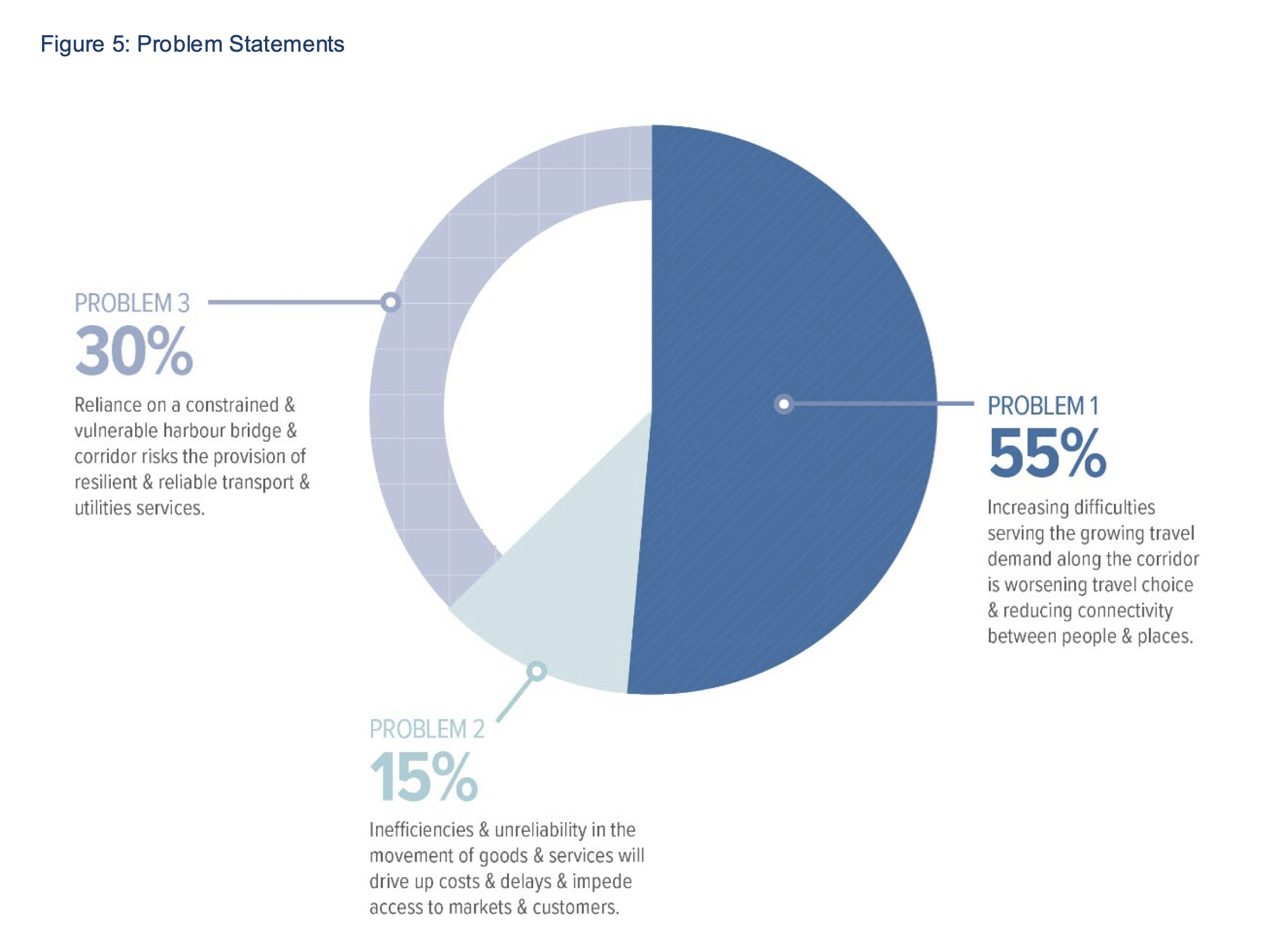
As defined, just over half (55%) of the problem is growing demand for travel (both evident and projected) combined with worsening travel choice reducing connectivity and access. In other words, the problem is the combination of a growing population and a current single-mode crossing.
The second biggest problem is concerns about resilience – on the grounds that the current bridge is “constrained and vulnerable” – are rated at 30%, or just under a third of the problem.
And inefficiency (basically congestion and delays) makes up the remaining 15% of the problem.
So, if moving people better is the bulk of the issue, the next question is: who and what are we trying to move, from where and to where?
The Strategic Business Case gives this description of North Shore population and land-use:

Note the two key areas of population growth: greenfields to the north of the Upper Harbour Bridge crossing, and suburbs clustered around Rapid Transit Nodes, i.e. the Northern Busway.
The greenfields growth to the northwest is already substantially served by the Western Ring Route and the Upper Harbour Crossing (ditto, inter-regional highway traffic looking to skirt the city).
So, with the city centre as a major magnet for employment and education, the key question is: how can we efficiently and effectively give more people better access between the mid and upper North Shore, and the central city?
To answer that question, it helps to know how people are getting from the Shore to the city centre already, and what the trends are. Take a look at this graph from the Strategic Business Case, showing arrivals into the city centre during the morning peak.
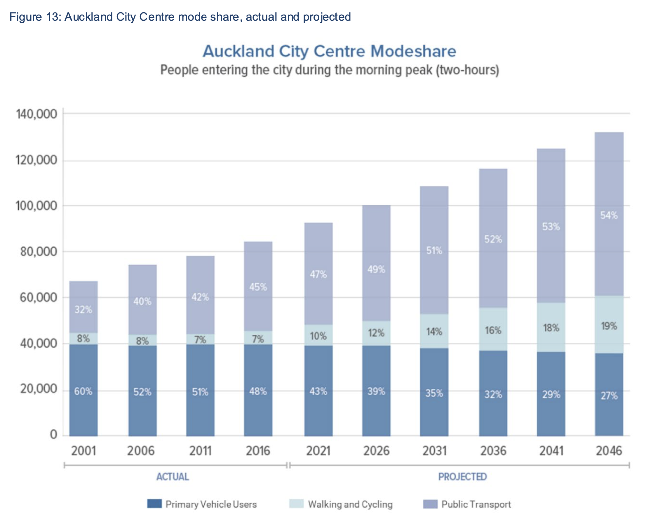
What stands out is that private cars are a shrinking subset of journeys to the city centre, and will continue to be so. Because space is permanently limited in the city centre – and it is already saturated with cars – growth can only come via other modes.
In other words, pretty much the last thing needed in a new harbour crossing is more traffic lanes. There is simply nowhere for more cars to go in the city centre. Nor the inner suburbs, including the North Shore inner ‘burbs. And the Central Motorway Junction is also already full, with little to no scope for widening.
So the solution to the question of better access for more people must focus on the missing modes.
Ideology is fatal to rational planning
Unfortunately, any impending government announcement of NZTA’s latest recommendation for a harbour crossing is already fatally flawed – because they’ve made it practically impossible to address the real issues as described in the strategic business case.
The problem is the handcuffs clamped on by the current Government Policy Statement on Land Transport (GPS), a document that governs project planning and funding for now, and takes the opposite of a “mode neutral” approach.
The brainchild of former Minister of Transport Simeon Brown, the GPS is so deeply at odds with reality and distorted by ideology that NZTA will find it impossible to both give effect to Brown’s GPS and reflect the actual evidence and best practice.
Therefore, you can expect them to recommend advancing a truncated version of the last announced scheme: road tunnels, again – but this time, to meet the requirements of Brown’s GPS, with rapid transit and active modes unfunded. Those will be pushed off way into the future, to be delivered only on the old bridge, and only after the tortuous two-decade process of building massive new road tunnels and renewing the old bridge.
In other words, if we’re lucky, we may get a couple of dedicated bus lanes, and perhaps a shared path by the mid to late 2040s. Or the 2050s, if we’re not lucky.
This is not a satisfactory or sufficient approach for Auckland in the 21st Century. From the Mayor on down, Aucklanders will rightly be shocked and appalled, if and when such a narrowly focused and ruthlessly unsustainable plan is announced.
And we should laugh it out of town.
Because here’s the thing. Resilience is extremely important, something NZTA well knows. You may have spotted the sudden recent uptick in stories emphasising the risks of the sole existing structure.
But if the Harbour Bridge really does have such urgent structural issues such that an additional crossing is needed ASAP – then NZTA needs to hit the brakes on their over-sized, extremely expensive, and decades-to-build road tunnel planning juggernaut.
Instead, they must get on with progressing a sensible, nimble option that actually has a prayer of being funded and delivered as quickly and affordably as we need.
And whatever-it-is simply must address the lack of transport choice (going on seven decades!) at the same time as addressing the purportedly urgent resilience risk.
The answer can only be an efficient, effective and elegantly designed bridge, without massive road interchanges at either side.
We believe this is possible. And we’re looking forward to showing you an option that meets the brief.
The money question: how to afford resilience
Any new crossing will be very expensive. And bridges are generally less so than tunnels – as well as being quicker to build (as long as they’re not ridiculously overscoped).
Therefore, while we get ready to design and build the new thing, every effort should be made to manage travel demand efficiently on our existing routes.
This is best practice. It’s what the Infrastructure Commission calls for. And it’s demanded by NZTA’s own official intervention hierarchy. Before you build new infrastructure, you must first consider integrated planning, demand management, and optimal use of your existing system.
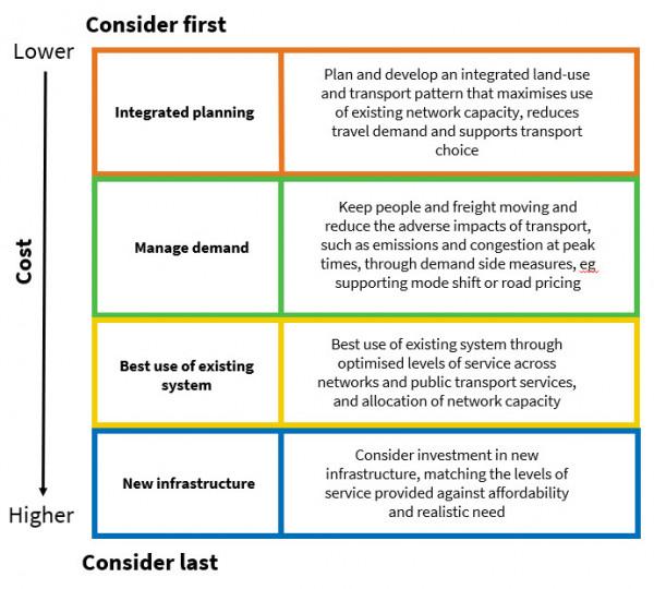
Happily, now that legislation allows it, the Mayor of Auckland is strongly pushing ahead with a road pricing scheme for Auckland, called “Time of Use Charging”.
Time of Use Charging, as the name suggests, would charge drivers a smallish fee to drive at peak times, in order to give them quicker journeys by incentivising anyone who can choose to delay or divert their driving journey to do so, thereby meaningfully reducing congestion for all.
Around the world, these schemes have typically lowered peak traffic by around 15-20%. That’s huge! Even half of that – the estimated initial impact for Auckland – would reduce delays significantly.
But for this to truly work, an essential part of the deal is that all income from the fee needs to go straight into optimising alternatives to driving.
In other words, every cent generated from time-of-use pricing must be poured into funding new and improved public transport operations, and new and improved infrastructure for public and active transport. A virtuous circle, which will expand the number of Aucklanders who can opt to avoid traffic.
But a problem will arise if this government – which is likely – opts for a massively expensive set of road tunnels, and then also commits to tolling the crossings with all income going to help fund construction and financing of whichever multi-billion dollar road-only scheme they come up with.
Tolling would conflict with any road-pricing scheme, diverting money away from complementary modes (again!), and towards building even more traffic lanes, thus trapping Aucklanders in congestion to infinity and beyond. A doom loop of despair.
So let’s not do that.
We know the problem, so let’s not keep announcing the same old solution
Auckland’s existing Waitematā Harbour crossings were built via three long-running and place-shaping (sprawl inducing) mega-projects:
- The original Harbour Bridge (1959)
- The doubling in width via clip-ons (1969)
- The Western Ring Route (1975-2022 many stages).
Which all have exactly the same characteristic – they are solely part of the road traffic system. They all provide for, and cause, more road traffic.
And since the original Harbour Bridge toll ended in 1984, the only demand-management tactic has been congestion and delay.
Unlocking full and genuine freedom of movement across the harbour is the key to an efficient, accessible and productive city that works better for everyone.
So why on earth would we even attempt to do that without using the whole city-mobility toolbox? We’d be that proverbial man with the hammer, seeing nothing but nails, and bullheadedly ignoring the nuts and bolts of rational 21st C city-building.
That’s madness, especially as we know what works. The dedicated Northern Busway (built in 2008, extended in 2022) has famously relieved the mono-modality of the bridge by enabling two highly successful partially-rapid bus services to help handle the huge and growing demand for city centre-North Shore travel.
Indeed, there is a compelling case that the Busway (and other bus services that cross the bridge) is the only reason traffic there moves at all during peak travel times. The impact is clear in this graph:
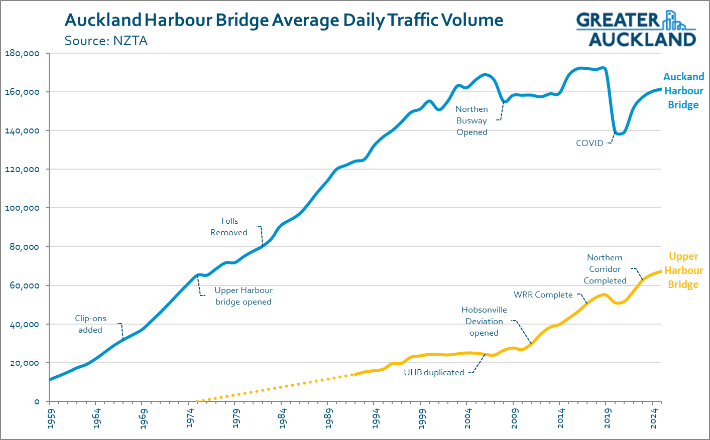
The NX North Shore express buses began service in 2006, and the Northern Busway itself opened in 2009. You can see the immediate impact on traffic across the Auckland Harbour Bridge.
And yet, these critical public transport services have zero priority on the current bridge. Buses are carrying up to 40% of peak travel demand, while fighting for space with general traffic (commuters in cars, and state highway through-travel) on the five peak-direction lanes.
Imagine how effective our rapid transit services (bus and/or train) would be, given their own dedicated and direct right of way? As proven by the Busway, a faster and higher capacity option is the most urgent task of any new crossing.
And if anyone still doubts the effectiveness of the only partially-rapid bus system across the harbour, check out the traffic counts at the previous eternally clogged Fanshawe St on and off-ramps. Spot the immediate impact of NX services from 2006-7, and the Busway from 2009 onwards. (And the change in working habits and travel habits from 2020).
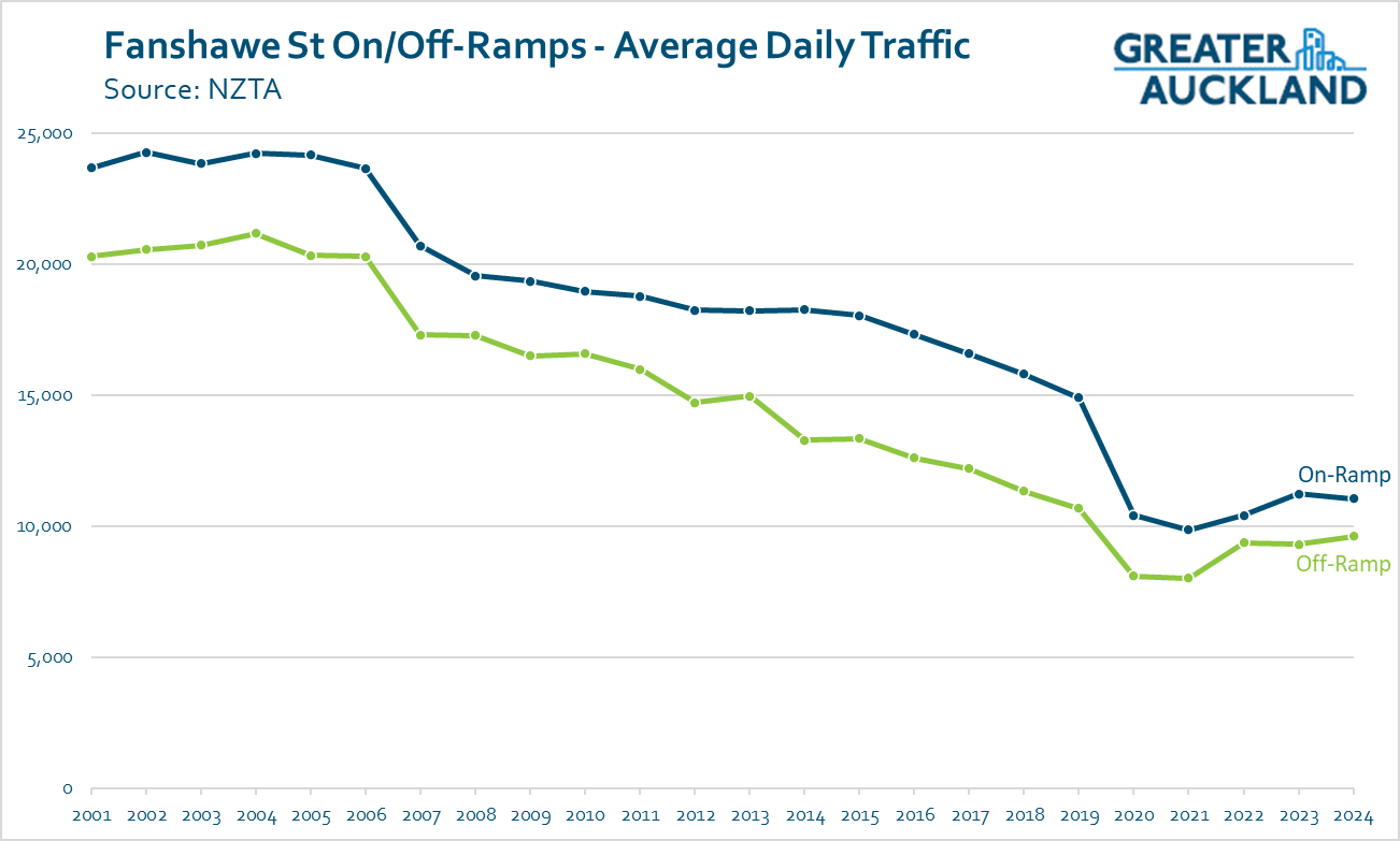
Clearly, significant volumes of people have switched to the bus because it offers a competitive alternative to driving (in terms of speed, convenience, cost, and comfort). As well as easing commuter journeys, this frees up space on the state highway for drivers looking to head past the city centre.
These are the kinds of convergent benefits that accrue when we focus on access, not just on traffic. Whatever we feed grows. Want more traffic everywhere, on North Shore city streets, ruining the city centre and inner suburbs, gridlocking all the motorways? Then build yet another road crossing.
Want something different? Build something different.
In short (the TL;DR)
It truly defies reason that we would set out – yet again – to try and solve the issues of access, efficiency, and resilience in our primate city, caused by the mono-modality of the first three efforts…
…by embarking for a fourth time on yet another road-only mega-project.
We’d be that other proverbial idiot: the one expecting different outcomes from the same action.
The great news is, we don’t have to be – if the next investment across the harbour gets it right. And getting it right will need everyone’s voices in the conversation. So, get ready to shout about it.
Stand by for a proposal from a leading transport planner in tomorrow’s post!

 Processing...
Mike Hosking and his readers would probably just dismiss it outright, with his article yesterday “We’re reliant on cars and we need to stop pretending we aren’t”. Sigh at the predicrable response from him https://www.newstalkzb.co.nz/on-air/mike-hosking-breakfast/opinion/mikes-minute-were-reliant-on-cars-and-we-need-to-stop-pretending-we-arent/
NZME’s newstalk listeners are dependent on cars. Mike’s right, even if they are sitting in congestion while listening to mike asking them to stop pretending.
Mike’s megaphone is funded by advertising, the largest being for the very same cars he’s telling his disciples they must have in their lives.
Patrick Morgans comments on RNZ this morning about certain politicians stirring up culture wars over poor city shared path infrastructure will never make it into NZME think space.
NZ is broken. The GPS specifies no walking, cycling or PT on the new bridge/tunnel. Mike’s right.
Arguably NZME’s Newstalk is also dependent on cars, seeing as 72% of people listen to AM or FM radio in the car. (search me as to why when there are so many much better options available for sounds than broadcast radio)
His comments were more restricted than what you are suggesting.
He was saying that we should not allow housing to be built without carparks and he is right.
Its not the same as saying that we shouldn’t improve public transport.
Depends on where. If an apartment building is built beside a train station and along a frequent bus route, then you don’t need 2 spaces per unit.
I don’t own a car. Why should I be forced to pay for a parking space that I do not plan to use?
What’s wrong with housing with no parking?
If you want parking for your steel/aluminium box that stays motionless for most of the time, pay a premium for it, which in this case is off street parking as on street parking should be banned (and I own 2 cars BTW).
Not to mention the view! Stu Donovan did a post on Linkedin a week ago stating that that made riding the bus in from the North Shore one of the world’s greatest commutes. No view from a tunnel, of course . . .
some really interesting rock strata and mud layers, a journey through our volcanic history. We need transparent concrete.
Before anything else, such a project needs bipartisan agreement. A Labour/Green govt will never agree to a “road only” plan, just as this govt was never going to agree to the light rail focused plan of the last govt.
The light rail part of this project was doomed to fail, because ALR and WHC project teams were pitted against each other (funding was only available for one of the projects), while simultaneously being told that both projects had to ‘align’, meaning their light rail components had to connect up with each other.
A heavy rail option wasn’t given proper consideration.
Thanks Patrick, im really pleased the NZTA funding for linking Aucklands CBD and North shore was delivered to the good people of Petone and Wellington on the stunning new path.
This is a tangible, walkable and ridable asset for Greater Wellington, deserved and appreciated.
I have no doubt that if after $50M+ of design and consultation on the skypath footpath arrived at a solution, it would have been stuck in another 50y death spiral.
Your article nails the issues – its not about a path but our inability to identify a problem, a solution and deliver an outcome.
Consultation is open on the new RUC system, but no capability for time of use road user charging.
NZTA as you say should lead with “integrated planning” getting better use of existing infrastructure before building new. Bike Aucklands smart peoples “Liberate the lane” solution to the bridge’s curfew for people unaccompanied by a car or truck, is not genius, its exactly NZTA’s process being used.
Thanks team – the bridge is now 67 years old. I got to ride my bike across it once (and back). Is that enough ?
https://www.youtube.com/watch?v=gR_GWI8LdB0
Gosh that was a fun day, thanks for sharing the joyful video. My overwhelming memory of that day is how happy the kids were in particular – and how easy and doable the ride was. Plus, the amazing views.
It truly beggars belief that our city isn’t racing to make the most of this amazing opportunity, not just for everyday travels for ordinary Aucklanders, but as a spectacular offering for visitors. What’s stopping us??
Yes, it’s crazy to think it’s gonna stuff more cards into the city or through the city. We shifted back to Auckland when the bus we must’ve opened in 2009. Public transport uptake since the revival has been pretty outstanding when you look back.
Looking forward to tomorrow’s post. Wondering who the planner is.
A couple of observations:
1) It seems the only real issue is that the bridge can’t handle heavy traffic forever. If that is the case a parallel bridge just for heavy traffic (trucks and buses) is the cheapest fix, but no one seems to be proposing that. Not sure if 2 lanes or 4 would be needed.
2) There is some merit in Brown’s idea. Like he says, if the harbour was a river we would have bridges in many locations, not multiple parallel bridges in one place. What happens at the northern end is a problem, but I suspect he must have though of that.
Not quite correct. The current bridge is a due a fairly substantial renewal. After which it will be able to carry heavier loads more securely, and indefinitely.
There is a bit of a PR campaign about the state of the bridge. This is a change from when I was a director and was assured that, with maintenance, the effective lifespan of the bridge, is infinite. And that like any responsible asset owner NZTA has always undertaken appropriate maintenance.
But also, we can see the situation is hardly anywhere near crisis as NZTA are not restricting heavy vehicles either to the West Ring Route, or to the centre spans only, or any other mitigation measure.
It is convincing that a series of staged larger renewals are coming due. To me this makes the case for a smart, quick, and cost effective first stage additional crossing, to enable the most spatially efficient journeys to continue, to allow successive lane closures for renewal work. A bridge, for Rapid transit.
I have no doubt clever engineers can devise a smart way to undertake this work, but is obviously way out of my expertise.
And no 2) < Brown fails to take his own correct advice, to address the problem case, and not just look for a new route somewhere.
His idea of yet another traffic only northern bypass (we have already done this with the WRR) treats the entire issue as if it is a traffic network issue alone. Not an access and land-use one.
See post above.
And that’s not even taking into account the place destruction and induced traffic such a new route would create.
What mode of rapid transit are you proposing for this new bridge crossing, because we already have bus rapid transit across the existing bridge
If rapid transit gets priority on the current bridge once the new option is built, you can rule out heavy rail forever. Its LRT or LM, at best.
A heavy rail crossing would need to be a tunnel to align with the city-side network
Yes. But my point was in the context of the new crossing not catering for rapid transit.
I don’t quite understand what you mean
We do not have any rapid transit across the bridge, we have buses leaving a busway to enter mixed traffic on the bridge.
So does that mean the Northern Busway isn’t rapid transit if you’re terminating in the city?
No, it just means it isn’t rapid for all of its route. So it is a partially rapid service.
A really good first step to improving access between the Shore and the City Centre would be to upgrade as much of the route as possible to separate it from traffic congestion, breakdowns, and crashes.
On the bridge, or on a new one, through St Mary’s Bay, and along Fanshawe St.
This certainly would be cheaper than a whole new system whether bus or rail, and valuable too, even when we’ve added that.
A ‘new system’ for buses would be another road bridge in this case
A new bridge with dedicated RT lanes, on grades that can be used by rail; ie Metro, light metro, or light rail would be useful.
The great problem for any system that doesn’t use or convert the busway is that it faces the problem of funding both a new crossing and a new RT right of way at the same time. If we have learned anything from the success of the last few decades it’s chop the big plan into fundable chunks.
any solution that may connect to the existing state highway north of the bridge should factor in that it can flood, and the fact the first few kms along the coast to Takapuna are far away from the population centres
Yes, and that’s pretty straightforward, tbh. We did that on the nor-western.
“I don’t quite understand what you mean”.
I don’t believe the additional crossing will have capacity for rapid transit. A lane or two will instead be freed up on the current bridge. Under that approach, heavy rail is off the table.
Almost all proposed ‘scenarios’ included multiple crossings:
https://www.greaterauckland.org.nz/wp-content/uploads/2023/03/Waitemata-Harbour-Connections-Scenarios.pdf
Heavy rail across the harbour, in the sense of an extension of the current rail network, is not on anyone’s table. There is no spare capacity in our little two track system to even run the CRL to the max, let alone another whole branch to 20% of the city.
It has long been clear that the next rail system will be separate, standard gauge. Either LR, so can have at grade sections, or fully grade separate automated LM.
Believe it when I see it
“There is no spare capacity in our little two track system to even run the CRL to the max, let alone another whole branch to 20% of the city” – what about those future-proofed stations, and doubled throughput at Waitematā? No level crossings to limit speeds on a tunneled line either
What Patrick means is there’s no way to create a junction with the CRL and a hypothetical North Shore rail line tunnel, and there wouldn’t be any spare capacity in the CRL with all the services going west, south, and southeast.
So heavy rail to the Shore would require a new east-west tunnel under the CBD as well as the harbour… and at that point you might as well build light metro, it’d be slightly cheaper (smaller tunnels & off-the-shelf gauge and trains, driverless operation) *and* easier to convert the Northern Busway by laying down tracks instead of rebuilding it all for higher axle loads and shallower gradients.
No way a heavy rail train could handle the gradient between Sunnynook and Constellation.
“there’s no way to create a junction with the CRL and a hypothetical North Shore rail line tunnel”
I would like to see some supporting info for this statement ^
No that isn’t what Patrick means, though that is difficult, I’m saying there is no value in it because the system is already full. The current network needs all the slots. Every time you add a branch, especially a major one, you spilt the capacity downstream. The rest of your comment is bang-on though.
So by adding new routes to the current network adds no net capacity to the system. Whereas building a new separate system takes nothing from the current one, all of its new capacity is additive. And if adding a new separate line it can have different characteristics, so of course you’d choose cheaper and better ones.
Connect to the current system via transfers, like in every Metro system on the planet. In LND the Northern line is not connected to the Central line which is not connected to the Jubilee line which is not connected to the Victoria Line and so on. They are all separate for very very good reasons. Especially for capacity and reliability.
And where, for historical reasons, they do have branches, eg the Northern line, there are almost always plans to separate them when possible. Part of the purpose of the new Battersea Station line was to increase capacity and reliability on Northern Line(s), by providing a second southern terminus so capacity is no longer split on the main southern branch.
How about a North Shore line terminating at Waitemata though? I don’t think it would be the best use of money compared to other options, but in a Sim City-world it might work?
Thought about it. If a North Shore line terminated at Waitemata, and did not continue through, it would effectively be a new network. The only benefit would be a level transfer to the other trains. Therefore, a more flexible approach using a different system that could connect to, e.g., a Queen St tram would be much better.
Anon: “Almost all proposed ‘scenarios’ included multiple crossings:
https://www.greaterauckland.org.nz/wp-content/uploads/2023/03/Waitemata-Harbour-Connections-Scenarios.pdf”
That’s the proposal when Labour was in, wasn’t it? Pre GPS. To quote Patrick:
“The brainchild of former Minister of Transport Simeon Brown, the GPS is so deeply at odds with reality and distorted by ideology that NZTA will find it impossible to both give effect to Brown’s GPS and reflect the actual evidence and best practice.
Therefore, you can expect them to recommend advancing a truncated version of the last announced scheme: road tunnels, again – but this time, to meet the requirements of Brown’s GPS, with rapid transit and active modes unfunded. Those will be pushed off way into the future, to be delivered only on the old bridge, and only after the tortuous two-decade process of building massive new road tunnels and renewing the old bridge.”
You are getting a road tunnel and the promise of other mode priority on the old bridge, just in decades to come. And that old bridge (and the gradients north of it) can’t do HR.
Build a new crossing for heavy vehicles only, running as close to the current bridge as possible. Toll it, and then toll SH16 for trucks too. Then make the current bridge light traffic only. Take away 3 lanes, one in each direction for buses, and one for active modes. Use barrier management to alter the lanes for peak periods. Congestion charging for the city centre (ie once you leave the motorway) would also regulate demand.
Not the best idea, but not as bad as some of the ones being thrown around.
The buses are the heavy traffic. The diesel double deckers are 4000kg over max weight without a special permit.
At the time I argued for adding two dedicated bus lanes to the bike bridge, so making it a rapid transit and active mode crossing. Diffusing the bike-hate aspect, even freeing up the gen traffic lanes by removing all the non-Ponsonby bus services from existing structure.
Bridge engineers said the difference to the structure of the proposed bike bridge would be trivial as it already had to be strong enough to support itself, that two more lanes, even with heavy buses wouldn’t add much more to the cost.
I still think this would be a very clever cheaper and quicker next step in a staged programme. The tie-ins at each end would be pretty easy. To get full value would need come with a lane shuffle through St Mary’s Bay and Fanshawe St with a full busway on the north side to connecting to it. And the same on Shore to Akoranga.
It surely would have a great BCR. A two lane BRT system can move 15-20k pax an hour
“but I suspect he must have thought of that”
You give him a lot more credit than I would.
My carefully costed decision is to strengthen and upgrade the existing bridge. The benefit to cost ratio is very high. This will have to be done in the next few years. Build more supports, replace weakened areas and build an extra lane or two just for busses and cyclists. Add congestion charging and fix the approaches.
“Build more supports, replace weakened areas and build an extra lane or two just for busses and cyclists”
Agree, except just do that alongside as a new bridge.
It can’t be strengthened anymore.
Because of the changes to the GPS and Bishop’s insistence that road project’s business case don’t need to be judged by other infrastructure standards, this a done deal. An expensive, vehicle-only, tunnel.
The RT priority and active mode access will be confirmed, via reallocation of current lanes, somewhere around 2045.
NZ will never learn.
I can never understand this bridge thing is the present bridge going to fall down? Take the clip ons off and build another more or less next to the existing one I’m sure the original part of the bridge will still be standing in another 80 years; two bridges are better than one or a tunnel.
Might as well leave the clip on’s there rather than the cost of removal, and turn them into a cycle / walking / viewing platform; without normal vehicle loads they should last much longer
Then a relatively narrow (4 lanes?) of traffic for buses/light rail and heavy vehicles
Calling the current GPS the “brainchild” of the former Minister highlights reliance on an organ of questionable reliability.
With a new GPS expected “soon” we should insist on freeing this study from that short-term constraint.
Fanshawe St ramp usage shows what integrated transport planning can deliver. If you doubt it, try standing in the middle of Fanshawe St and playing “spot the car” in the morning. It can get quite boring at times.
Our core challenge is getting even more people expeditiously from one side of our harbour to the other. Using motor vehicle capacity as a proxy for people moving capacity is just dumb. But good business, for those powerful vested interests whose previous efforts in suppressing public transport improvements have resulted in NZ having the highest rate of car ownership in the world, and a comparatively under performing economy. We have been consistantly buying the wrong things.
Our half arsed Northern busway has actually performed miracles in moving more people through the corridor, and achieved this with only minimal loss of evironments to more tarseal.
The cross harbour route just needs some genuine rapid transit, double rail track, light or heavy, doesn’t matter, either over or under the harbour. All bog standard, high capacity transit solutions in use in most comparative sized cities worldwide.
New roading lanes across the harbour though will require the same number of new roading lanes both ends through the most valuable commercial and residential land in the country.
And then even sacrificing even more of that valuable land for just car storage between daily commutes.
I’d rather we just stop spending yet more money consulting, reporting and making zero progress on this project?
We are clearly not ready for this, but we keep on pouring money down this reporting drain.
waiting for that ‘build a new replacement superstructure next to the harbour bridge and push it onto the piers’ proposal to get mentioned again
The present fuel crisis is showing the folly of having a transport system so heavily dependent on roads with much of the population wedded to their cars and trucks for moving freight around the country.
Auckland needs to invest in a rail and tram network that covers all four corners of the city, in conjunction with a new multi-model harbour crossing.
The current Auckland Harbour Bridge needs to be replaced with a new bridge, to a design similar to that proposed with the ANZAC Centenary Bridge a few years ago, which would incorporate road traffic lanes on the top, with rail, pedestrian and cycle paths underneath, running in a more direct route from the Victoria Park flyover in the CBD through to Northcote Point:
https://www.greaterauckland.org.nz/2009/12/04/anzac-centenary-bridge-information/
https://www.greaterauckland.org.nz/2009/12/03/the-anzac-bridge-idea/
Trams need to be reintroduced to Auckland in conjunction with congestion charging and a new harbour bridge. A new light rail tram line could run from Britomart to Takapuna via the new bridge, extended into a new central city loop running from the Wynyard Quarter to Britomart, up Queen St, along K Rd to Western Springs, and Ponsonby Rd, down College Hill back to the Wynyard Quarter. Light rail could also be added to the Northern Busway, linking to a line along Symonds St and Dominion Rd.
The new bridge and light rail could be funded with congestion charging on all motorways across Auckland, with removing all the congestion-causing on-ramp signals on the motorways and replace with toll gantries. There would still be free routes with using local arterial roads like Great South Road and Great North Road.
Land that the current motorway approaches to the existing bridge sits on, could also be sold to offset the cost of the new bridge.
Northern busway should be converted to light rail – and cross in tunnel to the City Centre, and then those trains per hour could either terminate at 1-2 city centre light rail underground stations (Seattle style) –
or – continue down some of the previously mapped out routes, Dom Road and 1-2 more via Sandringham, Three Kings or Epsom – and then to Onehunga for a big terminus situation (with 2-3 lines converging there)
As this would be high frequency and even Dom Road isn’t quite dense enough – compare to the north side which is all park & rides…
from Onehunga, who knows. Go up the rail line to Penrose… or towards the airport…
Strengthen the existing piers and progressively replace the existing 8 lanes with two levels of 8 lanes. The bottom level for trains, buses, cyclists and pedestrians, and the top level for cars and trucks. The down side is it would take 2 or 3 election cycles and the current NZTA consultants would have to actually design risk for their fees, as opposed to feeding the hapless politicians with reports to gather dust.
All made worse by NZTA’s own policy document on its application of the “decision-led approach” to state highway building, which in a matter of words basically states that the public should be shut out of big decisions and only consulted on inconsequential matters.
Yes! Feeding time-of-[road-]use fees into funding improvements to public and active transport alternatives is truly a virtuous circle. I tried to explain this to a transport planner in Melbourne 24 years ago and they responded that “we can’t pick winners and losers” – I was so flabbergasted that they didn’t see this as a win-win situation that I became speechless. Hopefully ideas have changed a bit in the transport planning profession since then, but I can just imagine certain politicians and bureaucrats in NZ responding the same way now. I guess we need to be able to show tried and tested empirical examples of where and how this has worked well in order to counter the knee-jerk neoliberal mantras.