Talk about an additional harbour crossing has existed for decades. With this post I thought I’d look at some of the many proposals that have existed over the years.
Presumably the first discussions about building a new crossing happened shortly after the existing bridge opened in 1959. I also assume those first discussions ultimately became the clip-ons that were completed in 1969. Following their completion traffic volumes quickly increased and there was certainly discussion about another crossing in the mid-70s. In a series of op-eds in the Herald during 1975, Mayor Sir Dove-Myer Robinson said that a decision on a new bridge or tunnel was urgent, claiming the bridge would reach “maximum carrying capacity” by 1981/82.
Of note, at the time of his writing, the bridge was carrying about 65k vehicles per day, nearly double what it was before the clip-ons opened 6 years earlier. Likely impacted by the oil crises of the 70’s, growth slowed and by 1982 the bridge was carrying 80k per day. Had that growth continued at the same rate as prior to 1975, a 1982 estimate would be more like 100k. Either way, these clearly weren’t maximum capacities as the bridge currently carries about 171k vehicles per day.
I’m not sure if there were any formal investigations to new crossing routes but the first one I have found any records of is from 1988.
1988
The study was for the Auckland Regional Authority and done by the Maunsell (now subsidary of AECOM), Parsons Brinckerhoff and the Ministry of Works and Development. Unfortunately I’ve only got the PT route options but they give a good idea of the thinking at the time. The notes suggest the crossing would have been used by either light rail or a guided busway like Adelaide’s O-Bahn.
There were two route options each for either a bridge or a tunnel. The tunnel would have been an immersed tube, instead of a deep bored tunnel (like Waterview). One option would be just east of the existing bridge and connect to the city through Wynyard, much like current plans, and the other would have cut through the tip of Bayswater and Stanley Point. The tunnel options seem to involve some amount of reclamation for ventilation and presumably to surface the vehicles.
Tunnel options
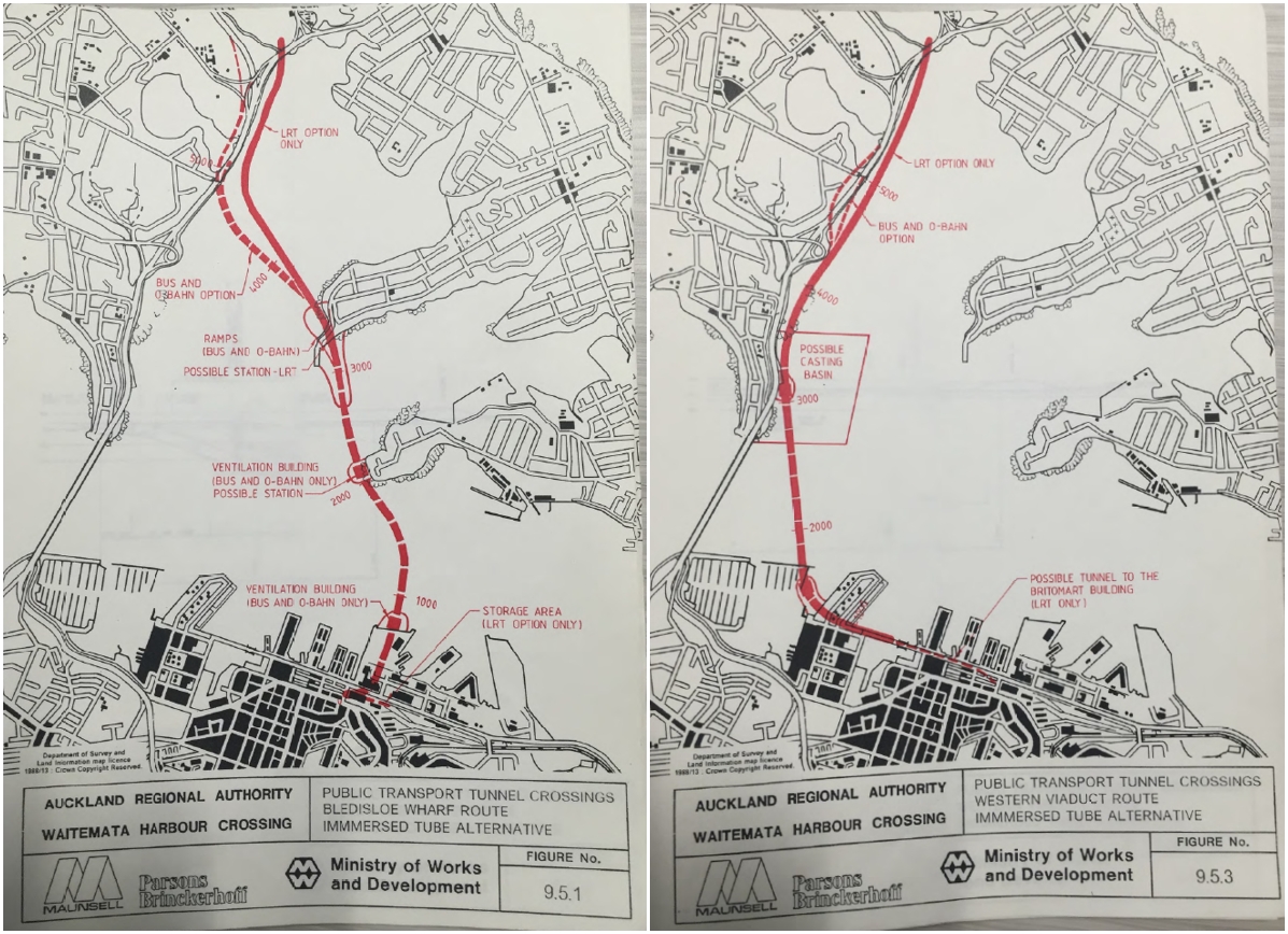
Bridge options

For the bridge option there are also some drawings of what it may have looked like.

1997/98
1997 saw a significant study undertaken for the Auckland Regional Council by Opus.
One thing it notes in its summary is
Traffic forecasts for roading options indicate that the additional cross harbour capacity provided by a four lane crossing is likely to be fully utilized not long after the year 2021.
The study looked at 14 different corridors comprising of 48 options bridge and tunnel options before narrowing down to a shortlist. Some of these were real doozies and would have had monstrous impacts on the city centre. Many were also aligned to connect to the now defunct Eastern Corridor.
All Bridge Options

All Tunnel Options

Shortlist Options
After further assessment, a shortlist of options was created. These are shown below with tunnels as dashed lines

A summary of the assessment of those options is below. As a guide to the listed cost, The RBNZ’s inflation calculator says that $100 million in 1997 is worth about $153 million now. That would put even the most expensive of the options, a tunnel from Esmonde Rd to Judges Bay, at about $2.6 billion.

You may notice mention of two public transport options which would hook into the future Northern Busway.
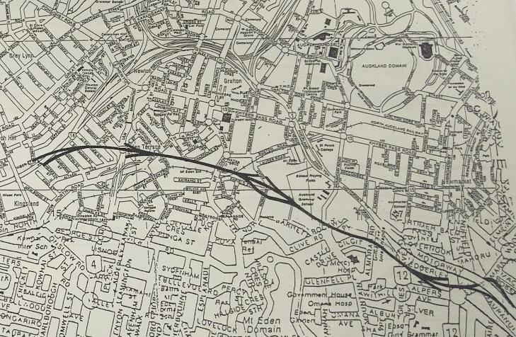
Like with the 1988 report, there are a few drawings of what some of the options would look like. The most notable are:
Option 3.1 carving across Devonport, having already crossed Bayswater.

Option 15 which would have put a motorway down Wynyard Point, the western side of Wynyard Quarter and a new viaduct through Victoria Park
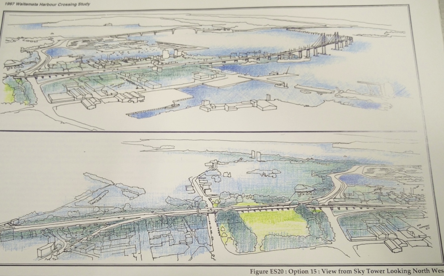
What is not shown in this image but you can see on the map above is that route 15 also includes this above-ground route straight though Auckland Grammar.
In 1998 the options went out for public consultation and following the feedback it was decided the next crossing “would be situated in the vicinity of the present harbour bridge“. Also that whether a bridge or tunnel across the harbour, the crossing would connect directly to the Northwestern Motorway via a tunnel through Ponsonby.
2003
Following the study above, in 2003 Transit NZ (predecessor to the NZTA) undertook another study confirm the options that would be meet the outcomes decided from the 1997/98 study. You can see the document on the wayback machine but unfortunately the graphics are low quality.

A preferred option for a bridge and tunnel scheme where selected. No definite cost was given for the options but it does note that any option would likely cost more than $3 billion ($4.3 in 2019).
The preferred tunnel would have been an immersed tube following the dotted line and connecting to the CMJ. It would not have had the tunnel connection to the Northwestern as would use the above ground connections that have since been built.
The preferred bridge option would see the motorway cut under Northcote Point leading to a bridge 500m west of the existing bridge before connecting back around Pt Erin where the route would dive into a bored tunnel under Ponsonby. An artists impression of the bridge of which is below.

For those interested, the document includes some smaller images of the bridge options for either side of the existing bridge showing some very utilitarian structures.
2008
With the planned redevelopment of Wynyard Quarter it was decided another study was needed to reassess crossing options. This study was primarily undertaken by SKM (since acquired by Jacobs).
Like with the 1997 study, they started with a long list of potential options. This time the number of them had expanded to 159 and included heavy rail linking into Britomart. The image below is a more recent high-level graphical representation of those options – bridges and tunnels on the same alignment were considered separate options.

This was then whittled down to a shortlist of three alignments,each of which had a few variations within them.
This was further refined and Option 2C, using bored tunnels, became the recommended option. A feature of this, that continues in the proposals to this day is that the Harbour Bridge would effectively become one big off-ramp to the western side of the city with the new crossing only being for traffic bypassing the city or heading down Grafton Gully.

2010
The 2008 study lead into a more detailed business case by PWC and various other assessments that took place in 2010. That work estimated a road bridge would cost about $3.9 billion with a Benefit Cost Ratio of 0.6, a road tunnel about $5.9 billion with a BCR of 0.4 and a rail tunnel $1.6 billion (no BCR stated). Given what we’ve seen happen to the costs of other projects since then, most notably the City Rail Link, those costs are likely a lot higher now.
Some of the drawings of the bridge versions of that are below.


2019
Since 2010 work on another crossing has focused on protecting the route but there has been little information in public on just what this entails. We do know that another look at alternative routes, likely similar to what happened in 2008, occurred in 2016 and 2017 as part of the route protection assessments. It was also decided during the Auckland Plan process that a tunnel would be the preferred solution. This has often felt as if it’s more about no one wanting to make a decision on a structure that would so dramatically change the skyline than anything else.
Another change in recent years has been a focus on combining the road and rail tunnels into a single crossing instead of having them separate. At first I think this was more about finding ways to get a quicker and cheaper rail crossing built as the original plan was to repeat the mistakes of the past and build a new road crossing but leave any rail crossing for a separate project.
 But the most recent information released by the NZTA suggests some thinking on the makeup and timing of projects may have flipped. A PT crossing is now accepted as being needed sooner than a road crossing but the highway engineers seem to want to keep the tunnels combined as it likely now the only chance they’ll now get to also get a road crossing. That information came from some new modelling showing that building a road crossing was a waste of money as it undermines Aucklands strategies and actually makes congestion worse. It suggested the best outcome came from building a light rail only crossing.
2009 – ANZAC Bridge concept
In 2009 a group of private companies suggested a new bridge to be built by 2015 to commemorate the ANZAC centenary. It would follow a similar alignment to option 2C from 2008. What was interesting about this proposal is they planned it to replace the existing bridge rather than add it as an additional crossing. They would pay for at least part of it through redeveloping the land used by the motorway through St Mary’s Bay and along the eastern edge of Northcote Point south of Onewa Rd – an idea that seemed improbable.


What have we learnt
Unsurprisingly the general route concepts that came up 30 years ago are the same ones that come up today, albeit with minor tweaks. This is not surprising given Auckland’s geography hasn’t changed during that time.
One thing that is clear though is discussion about a new crossing has been a great make-work scheme for consultants with major repeats of the same work coming out every decade or so. Since 2013 alone the NZTA has spent about $25 million on investigating another crossing and $55 million on property purchases. I wonder how many more millions have been racked up over the previous decades investigating the idea.
What’s also clear is that predictions about the existing bridge running out of capacity or there being an issue with the clip-ons, thus requiring a new crossing are often woefully inaccurate. Related to this, perhaps the single biggest thing that has reduced the need for another crossing has been the advent of the Northern Busway which has meant a lot more people can cross the bridge at peak times.
I think we’ll hear calls for a new road crossing continue to pop up over the coming decades and we’ll probably see these evaluation processes continue to occur.

 Processing...
Umm, hold on. “$100 million in 1997 is worth about $153 billion now”. Want to correct that? Presumably not correct?
Yes a typo, should be $153m. Corrected
There must be some psychological aspect to all this. We don’t spend millions of dollars over decades, seemingly endlessly, to look at other motorway realignment options for existing motorways.
Is it because there is “space” (i.e. the water) that they can draw their lines on with little consequence?
We did exactly that with the Waikato exlessway, Kapiti Expressway, Hawkes Bay Expressway, SH 29 realignments, and SH2 between SH1 and SH25 or KatiKato to Tauranga. They were all drawn and redrawn from the 60s onwards.
You can still see the old designation for the Hamilton bypass on google maps a 100 m wide paddock stretching several kilometers off the end of resolution drive.
“100 million in 1997 is worth 153 billion now” . Wow. Or is this a typo?
Typo and corrected
Thanks Matt do you have current stats for the bridge. What I would like is
For a university day
1 Total vehicles across
2 Number of working buses across
3 Total number of people across
4 Number of people on buses accross
Ah the infamous LRT connections to Britomart. How much trouble we could have saved if Britomart had actually been built to the original spec instead of suffering from ruthless penny-pinching revisions….
What penny pinching revisions are you referring to?
The original Britomart scheme under Les Mills was much larger but that was because it included an underground bus station and carparking. I don’t think it had any additional train capacity and will with the trains being much deeper, would likely have meant the CRL was not feasible.
Also at the time of those crossing plans, the thinking as to convert the rail lines to LR.
My understanding was that at one point the Britomart plans included a fairly comprehensive redevelopment plan that extended much further East than the Britomart precinct we have now.
The original Britomart scheme was very modest. It had the old carpark being demolished with at grade rail lines interchanging with buses for something like $19million. Then the property wing got involved and turned it into a major land speculation project.
Traffic engineer lets slip that he skipped that class where they pointed out that transport is only a means to an end, and not an end in itself, and that that end is pretty much summed up as ‘positive change in land value’.
* just kidding, of course there’s no such class in traffic engineering.
Very witty Wilde. But you are close to the truth. They did the old Transport Planner two-step where land wasn’t given any value at all. On the positive side it did make provision for buses without requiring lower Queen Street to be turned into a bus-yard. But then the Les Mills scheme went the other way of including as many high rises and as much parking as they could fit to maximise land value, while including the bare minimum for rail so they could still call it a transport project.
Seems to me as though we ended up with a pretty decent outcome in the end, an underground station that can connect into the CRL.
Yes and the retention of a heritage area. But Christine Fletcher took a lot of flack for what has turned out to be a very good plan.
Should be her name on the plaque in the old CPO, not bloody John Banks!
Agree to all this. Mills scheme was appalling and the current one is a great mid point between ignoring land value and greedily and destructively trying to snatch too much of it. Akl is very lucky to have Peter Cooper and Britomart.
Now it’s spreading west across Queen St, about to be truly wonderful open space, to Commercial Bay. Though without the texture and unplannedness of the old buildings. And really none of this quality is possible without the Transit service below, on the harbour edge, and win the streets.
Very excited about this city atm; this is a big change moment.
Funny, I just went back and checked what it says on Slide 1 of my BE(Civil) “Intro to Trpt Engineering” course (2004-16):
“What is Transportation Engineering?
– A Means to an End only!
* Movement of People and Goods
* To facilitate social / economic activities of community”
Hopefully some of them took note… 🙂
Well Auckland has suffered a lot from destructive motorway building over this period but clearly it could have been much worse!
One thing that comes loud and clear through this parade of plans is that there is no obvious option for another road connection here. And for good reason: It was a mistake to take SH1 through the city in the first place, so doubling down it again is doubly bad. The city itself needs less traffic not more, and the through route is full already, all the way down. Hence all those long tunnels to try to get to clear tarmac. But there is none; none south, none northwest.
It wasn’t even the original recommendation; bypassing was always understood as the best highway/city relationship. Unlike Rapid Transit, which can take people to and through cities without harming the very thing it’s supposed to serve.
Am reasonable confident that time, and cost, will eventually lead to the recognition that what must happen now is for NZTA to finally grasp that this is a rapid transit project only.
That combined tunnel idea is the desperate last gasp of these unworkable and more importantly, undesirable, schemes.
Let it go, HNO.
Would redesignating Sh16,18,20 as sh1 help funnel traffic away from the bridge/cbd?
I doubt it, people don’t make their travel decisions based on the number on the sign, they decide based on what is quickest.
must be some way to encourage people to use the bypass theyve spent billions on surely.
The best options would be either removing lanes in the CMJ or some sort of tolling.
Bear in mind that the vast majority of trips on the motorway network are not between Manukau and the North Shore. The ring route primarily serves the purpose of making North to West and West to South journeys easier, this alone will be removing some traffic from the CMJ.
No they don’t! Google decides what’s quicker.
Even a toll to discourage the heavier trucks from using the Bridge.
toll all vehicles, not just heavies.
“The city itself needs less traffic not more, and the through route is full already, all the way down. Hence all those long tunnels to try to get to clear tarmac. But there is none; none south, none northwest.”
The CMJ was designed with the dominion road motorway in mind.
Convert ian mckinnon drive into a motorway as originally planned, demolish the new north rd/dom rd interchange and use the site as a tunnel entrance.
Connect mt eden station to the tunnel and have a combined road and rail tunnel under dominion road. This would give a direct rail connection from the suburbs just south of the cbd to the CRL.
I can just imagine that meeting – “Why don’t we exploit the name ANZAC to get an unpopular bridge built?”
Wasn’t that a proposal, and a name, adopted by a consortium of construction companies, building material suppliers, and roading consultants? Wasn’t it, just a later more subtle iteration of the “Roads not Rail” lobby group? This group at least were completely honest in what they were lobbying for.
Isn’t it true that a large reason for the lowered capacity projections in the early days was when the bridge was tolled (one way)?
There was a significant loss of carrying capacity right there – at least in the tolled direction as vehicles slowed to funnel through the toll booths, paying the toll then heading away.
I do recall when the bridge was tolled, during the PM peak, even with all toll lanes open there used to be a massive “free for all” as motorists switched lanes left and right to find the shortest tool booth queues in an attempt to try and save a few seconds. With consequent slow downs “tail backing” to north bound traffic on the bridge and motorway approaches.
And once the tolls went away, a truer bridge capacity was revealed.
Then with the tidal flow barrier (aka “The Snake”) extra peak direction capacity was added to the bridge.
All in all, the whole capacity growth story of the bridge enabled via clip-ons and everything afterwards were pure and simply enabled by the original design allowing for more than 4 lanes when the bridge was originally designed.
So that the bridge footings were designed for a much bigger load than they actually had to carry. Leaving room for Clip-ons, The Snake, and ultimately, HPMVs, and now Skypath.
It is true I think, that the original design having heavy rail on it, meant the core bridge had to be strong and have much larger footings that a straight road only bridge would have had (then, or now).
Without that original good design decision we would have had to have built a second harbour crossing long before now. As the limitations of the original design would have become all too clear. Likely long before the original bridge cost was paid off via tolls.
But that future proofed decision that should have unlocked a better outcome has been a mixed blessing, as that capacity for enhanced PT originally allowed for, has simply been squandered by subsequent expedient decisions to basically cater for more & more SOVs to unthinkingly cross the harbour without any cost to do so. And with any allowance for any proper PT options given the heave-ho until fairly recently.
PT is still waiting for its fair share of the crossing space it was originally promised.
Questions are: Why is it still waiting? and how much longer will it have to wait?
With reports of world wide “Peak Car” likely having already occurred, now being more and more commonly reported in the media overseas, how long before bridge traffic levels start a permanent long decline?
Rendering the likelihood of any more road crossings completely unlikely if not already off the table as Patrick said.
And in the face of such a future, will we have to wait until the last Clip-on lane is fully empty of traffic before NZTA will consider putting Bus lanes on the bridge?
Or will we squander even more Billions on tunnels under the harbour, when the answer is staring us right in our face already – that is – use the bridge we already have, more effectively.
After all, isn’t that the biggest take away from the story of the last 60 years – rethinking and re-inventing whats possible to get the current bridge to carry has paid, and continues to pay massive dividends in the form of money on bridges and tunnels we haven’t had to build.
Can we go “Back to the Future” here and plan to improve the people and goods throughput of the bridge, yet again, with extending the Northern Busway onto the bridge itself?
Or will we be waiting another 60 years?
I am interested to hear what you think the configuration of the bridge should be.
I agree with you, Auckland should be at “peak car”.
The shortlisted 9.1 option is why the SH20 extension from Mt Roskill was moved from the Rosebank Peninsula to Waterview. It was to future-proof a further extension to the North Shore, via a tunnel under Point Chev then up and over a bridge over the harbour. It was the lead story on the front of the NZ Herald at the time.
Was the extra harbour crossing planned to replace the existing bridge? If not, then it
does not make a sense to add an extra lanes to already congested motorway. Or am I missing the point?
Yes the government can continue to spend millions every years on investigation. However nothing will be done and the money will be wasted.
People working in government investigation will never run out of work.
I’d happily pay these types to keep investigating. And furthermore, steer their thinking and investigating in the direction of maximising what we already have rather than keep imagining ever grander schemes to solve traffic problems.
Because in the cost comparison with the money that would be spent on building these schemes, these costs are absolute peanuts. Even if you consider it “waste”.
The only downside to this approach is the opportunity cost of these wannabe projects hogging large chunks of the transport budgets for years and years “just in case” project X or Y gets greenlit that year.
It is still true that the cheapest roads are the one you never actually build.
Fantastic article Matt, really enjoyed reading it! – So many options I think you’ve hit the nail on the head regarding no one wanting to be responsible for drastically altering Aucklands skyline. A tunnel seems like a good option especially if in integrates rail. Although I’m not opposed to a bridge if its done tastefully I think it would need to be a significantly further away from the harbour bridge towards Devonport/Bayswater so as not to look out of place that raises concerns of whether it would be able to connect with the exisiting infrastructure though. I liked the look of 4.1 and 4.2 in the earlier studies making sure it links in with all the peninsulas on the way down through bayswater and Devonport then linking in with the exisiting port exit for SH16.
Sam, are there plans to intensify housing development in Bayswater/Devonport?
Currently I don’t believe there has been significant changes to the zoning in those areas, mind you I have seen some zoning changes in Belmont and there is currently some large retirement village developments underway at Ngataringa and Eversleigh roads. Rezoning would be the easy part though! However I don’t think intensifying the density on those peninsulas is a great idea at this stage if you are aware of the current state of lake road something like this would help ease congestion on the daily commute, not only for Bayswater and Devonport but also those running southbound along SH1. Rezoning could be considered further down the line but initially this would provide more transport options for those living on the peninsula. An option like this could also provide rail links for Devonport, Bayswater, Eversleigh, Esmonde and linking in with Smales farm and repurposing the exisiting bus way… if that ever happens.
You’ve clearly never been to a community consultation in Devonport if you think reasoning the peninsula for apartment blocks will be the easy part.
Torches and pitchforks spring to mind.
All wielded by silver haired car nuts who decided everything was perfect in 1980 and any change since has been negative.
There is a lot of new intensified housing being built in place of the single family houses on huge empty sections that were Navy housing.
This is in both Hauraki and Bayswater.
As someone who lives on the peninsula, intensification is the only way forward. There should be no improvements to Lake Road to make driving easier. Any changes should (and are planned to) improve cycling and PT options.
If that means people who are wedded to their cars decide to leave the peninsula then so be it. Thye are mostly from a certain generation and it would be great to have more young families in the area.
Maybe then some progress can be made on making the Devonport village into somewhere actually worth visiting by having more housing available there. Right now it is resisted in the name of “heritage”.
Interesting post with all that history of options. They sure have had fun drawing lines on maps over the years. So many smashing through the city ideas.
Looking forward to a PT & active mode only crossing sometime in the future instead of this madness.