This is a guest post by Nicolas Reid, Technical Director – Public Transport and Rapid Transit at MRCagney and author of Transit By Design.
In this post – shared by kind permission (via Linkedin), Nicolas answers a number of frequently asked questions regarding his proposal for the next Waitematā Harbour crossing.
As we said a few weeks ago, this proposal strikes us smart, affordable, deliverable, and delightful. A multi-modal bridge, designed to complement the existing one, enabling freedom of movement for all kinds of journeys. A brilliant bridge like this – built beautifully – would be an iconic addition to our great harbour city.
This conversation belongs to everyone in Auckland, and we think this bridge proposal is a great one.
A few weeks ago I posted our concept for a multimodal bridge in Auckland, as a smaller-scoped, more affordable yet high benefit solution to the next Waitematā Harbour Crossing. Naturally that kicked off quite a lot of robust discussion!
I’ve had many questions from people asking about what it is we’d come up with, where it goes and why, so I thought I’d write up an FAQ and post here. I’ve also added a couple more diagrams with more details like everyone was asking for.
So let’s keep the discussion going. Please add your ideas, opinions or critiques in the comments below, plus any further questions or clarifications. I’d love to hear what you think, what we have right and what we have wrong.
What is proposed?
A multimodal bridge with rapid transit, motorway lanes, plus walking and cycling. In combination with the existing bridge, the Waitematā bridge would effectively add across the harbour:
- Two new rapid transit lanes (busway to begin with, then light rail or metro)
- Two new bus lanes
- Two extra counterpeak motorway lanes
- Separate walking and cycling paths
It would allow the motorway to run at four lanes each way at all times, dedicated to carrying state highway lanes through to SH1, SH16 and the port. There would also be two lanes dedicated to traffic accessing the city centre and central suburbs. The state highway lanes would be separated from the city traffic lanes to a large extent, effectively bypassing the city centre and city commuter traffic queues. The movable barrier system would no longer be needed, as the current peak traffic capacity would be available in both directions at all times
The motorway lanes on the new bridge would be four lanes southbound, leading to the four lanes on the Victoria Park flyover. However, during planned maintenance, the new bridge would run as two motorway lanes in each direction. Initially this would allow the original harbour bridge and then the clip-ons to be closed in long stages for major renewals, while still keeping the same lane capacity as today.
What isn’t proposed
This proposal doesn’t add any more peak direction traffic capacity. The traffic lanes that are added are for the motorway in the counterpeak direction, and interpeak. This aligns the motorway lanes across the harbour with the capacity of the motorway on both sides at all times. It takes advantage of the spare capacity afforded by the current movable barrier design, but allows the maximum use of the existing state highway network both ways, not just in the peak direction.
This bridge also doesn’t add any extra off-ramps or traffic capacity to the city centre or local streets – getting more cars into town is not part of the design concept. However, city traffic may flow a bit more freely given less interaction with the motorway and vice versa.
The existing car commuter access to the city centre is maintained, but a huge amount of additional capacity is provided with the rapid transit lanes from the upper North Shore, the dedicated bus lanes from the lower North Shore, plus the walking and cycling links.
Is the bridge the pinch point, or the approaches?
Like the often repeated myth of the ‘planning disaster’ that led to the Auckland Harbour Bridge being doubled in width with the clip-ons, there’s also a truism going around that the Harbour Bridge itself isn’t the problem for traffic congestion, it’s the approaches that are the pinch points.
That’s not really true, because the congestion occurs where the approaches narrow down to meet the pinched capacity of the bridge.
The harbour bridge is eight lanes wide. Meanwhile, the motorway either side of the bridge is ten lanes wide for general traffic, and twelve lanes wide when you count the bus lanes and dedicated off-ramps. To put it simply, there is already considerably more capacity in the highway and busway network either side of the harbour bridge than on the bridge itself.
We already have five motorway lanes in each direction leading to and from the bridge because of the movable barrier system. This shifts the eight lanes on the bridge to be five in the peak direction, and three in the counterpeak direction…. Which means that going north in the morning or south in the afternoon means experiencing the traffic that results from squashing five lanes and the buses into to just three lanes over the bridge.
To be blunt, that’s a 20th Century approach to traffic management aimed at prioritising car commuters driving to office jobs downtown, one that’s no longer the most efficient outcome, and it’s a big part of the current problem: we actively take lanes away from the strategic state highway corridor to give them to single occupant commuters going to downtown.
Why build a new crossing near the existing bridge?
A bridge from the North Shore to the city centre is exactly where it is needed to complete the missing rapid transit, walking and cycling crossings of the harbour.
It’s also where there is spare counterpeak capacity on the motorway that can’t be used currently, leading to traffic congestion that is as bad going north in the morning and south in the afternoon as it is in the peak direction.
It’s also what works best in conjunction with the current bridge to get buses and private vehicle traffic to the city centre and central suburbs.
Putting a new crossing anywhere else requires pushing motorway or local roads through existing city neighbourhoods or suburban areas to reach it on both sides, plus the addition of new rapid transit lines and walkway and cycleway links. That means many kilometres of house demolition and road building, or many kilometres of very expensive tunnels and viaducts.
Why not right alongside the existing bridge?
This is an option that some people prefer, based on the idea that a new bridge will blend in with the old one and have fewer physical or visual impacts. It also means a slightly shorter bridge.
However, the route overall is longer than going straight across the harbour. In particular, it requires adding extra lanes for the new modes along 1.5km of waterfront through Saint Mary’s Bay, in an area that is already very constrained. This would have big impacts on Westhaven Drive, the marina access and what remains of St Marys Bay beach.
Likewise on the northern side, there would more impacts on Northcote Point. The direct route across the harbour skips St Marys Bay entirely, and in fact would allow the current roadway to be reduced by three lanes in width, freeing up space to make public realm improvements to the waterfront.
Why a bridge and not a tunnel?
In short, bridges are lot cheaper than tunnels. That means a bridge is both more affordable in the first place, and better value for money in the second.
It also makes for a smaller and shorter construction programme with less risk, shaving years off the build and reducing the likelihood of lengthy delays and costly blowouts.
As well as being faster and cheaper build in the first place, bridges are much cheaper to operate day to day. Long tunnels have an extra layer of fire and life safety risks that mean much greater monitoring and control systems, more arduous evacuation requirements, and more frequent service disruptions to manage them.
All else being equal, a bridge will have more robust operations than a tunnel on the same corridor, which translates into higher capacity too.
We’ve proposed a cable-stayed bridge because this looks to be the best design for the context. Cable-stayed bridges are strong and stable, and they can span significant distances across water without needing dozens of piers driven into the seabed. They are resistant to wind loading and suitable for earthquake zones.
Most importantly, cable-stayed bridges can be built relatively quickly and cheaply without the need for falsework supporting the deck from below. Having said that, I’m definitely not a bridge engineer and am interested to hear if there are better approaches.
What about rail?
This bridge proposal is compatible with several options for bus and rail to run in the rapid transit lanes. The width of the rapid transit lanes and the grades of the bridge and its approaches are suitable for Auckland’s’ current conventional busway buses, as well as special rapid transit buses, light rail or metro rail.
The most pragmatic option is to use these lanes to extend the existing busway across the harbour to the city centre, as much of that infrastructure already exists, and the improved busway would perform very well.
Light rail would be an excellent outcome with improved performance and capacity, but it would require adding at least the first stage of a light rail network to the harbour crossing project, a big increase in scope. Likewise metro rail would be a very high-performing option, but it would come at a very high additional cost added.
Light rail or heavy rail could be part of the harbour crossing programme from the start, or they could be added as a subsequent stage.
Heavy rail is not proposed, as allowing for it would add a huge amount of cost to the crossing for little extra benefit. The North Auckland Line already carries heavy freight north around the harbour, while the transport needs of the North Shore are better served by rail modes specifically designed for urban rapid transit.
Heavy rail built to mainline specifications does not fit within the proposed bridge design envelope as it is proposed. It requires broader curves and shallower grades than what light rail or metro rail designed just for urban passenger transit is capable of. In simple terms, Heavy rail would require structures that are twice as long so they can be half as steep, and curves that are twice as broad. This design constraint isn’t just for the bridge crossing itself, but the approaches to it.
Furthermore, there isn’t spare capacity in the rail network or the City Rail Link to add in an extra heavy rail line from the North Shore. The capacity of the city tracks and stations is all planned to be utilised for the existing lines. This means heavy rail across the harbour would also require expanding the scope to include an equivalent to a second City Rail Link to connect the harbour crossing to the city centre.
Will this proposal fix the traffic?
No infrastructure project will fix peak traffic congestion, but this will ease the level of congestion, reduce the impact of commuter traffic on the state highway, and stop it spreading as much across the day. It will reduce the impacts of delays and disruptions.
More importantly, it would let a lot of current and future residents travel quickly and easily without being in traffic at all. The improvements to buses, rapid transit, walking and cycling would allow hundreds of thousands more people to cross the harbour each day without contributing to traffic congestion at all.
Does it do everything we will every need?
A new bridge will last a hundred years. It might not solve all our transport problems for a hundred years, but it will still keep working and moving tens of thousands of people per hour for all that time. With a relatively small scope and cost, this can be the next step in a longterm programme of improvements. It won’t necessarily be the last crossing improvement ever built, and it doesn’t need to be.
Will a business case reveal the most efficient outcome?
Unlikely. Business cases tend to land on the most effective outcome regardless of efficiency or affordability. It’s an unfortunate outcome of the current planning process that business cases effectively only lead to one conclusion – the biggest most expensive outcome.
Business cases aim to eliminate a smorgasbord of often-competing problems and achieve maximal benefits across them all, trying to do everything in one project. This means doing more and more, a process looking for the biggest solution. The more problems you can come up with, the bigger the solutions are, and the better the business case.
In this process, the real cost of a project is only worked out after the problems are defined, the concept has been selected and the engineering solution is designed. Cost-effectiveness has little input into the design and evaluation process, and affordability is often disregarded as simply “that’s what it costs to fix the problem”.
This approach encourages scope creep, leading to massive projects that are unaffordable, poor value for money, high risk, and have very long timeframes to build and implement.
What is needed for a crossing that we can actually afford?
A better approach is to look the main issues and the main benefits, and find the smallest project that works with the existing context to solve most of the problems, with a close eye on the scale and cost of the project as part of the design process.
That leads to more affordable and more cost-effective projects with lower risk and shorter implementation times.
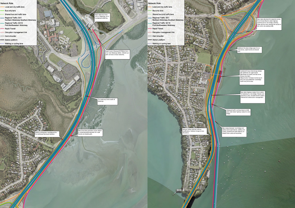
The motorway and public transport connections on the North Shore. Motorway lanes in blue, city access lanes in orange, bus lanes in green. New embankment with rapid transit and active modes in red.
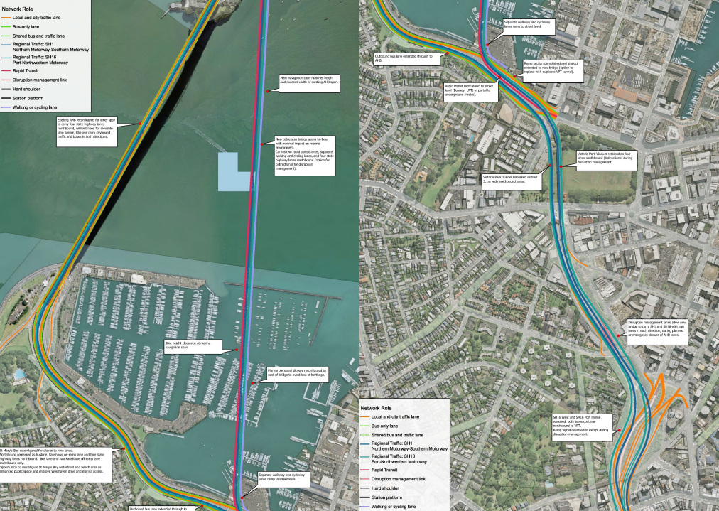
The Waitematā Bridge and Auckland Harbour Bridge, and connections to existing network at Fanshawe Street and the Victoria Park Viaduct and Tunnel.
I hope that answers the main questions so far. Once again, please do add your ideas, opinions or critiques in the comments below, plus any further questions or requests for clarification. I’d love to hear what you think, what we have right and what we have wrong, and what else to think about.
– Nicolas Reid
If you’re keen to support Greater Auckland’s work pushing for a brilliant, beautiful bridge as the heart of a top notch 30-year transport plan for our city, you can donate here. And as always, please feel free to share our work widely. This conversation belongs to ALL Aucklanders, and we all deserve to be part of it!

 Processing...
Brilliant solution as was the walkway/cycleway over the bridge which was
proposed by Cycle Action Auckland. We consulted, made plans for a workable, affordable pathway for cyclists and pedestrians only to see the project redesigned, re-costed and rejected.
History has proven that the CAA design known as Skypath was not a workable solution. It was never more than sketches and never addressed the engineering problems of attaching a clip on to a clip on. It beggars belief that the trust got paid a rather large amount of money for an IP that was never going to be used.
Missed opportunity to directly connect the walking-cycling lane to Te Ara I Whiti
Could the walking track be slightly re-directed to connect to where the bridge would be? Isn’t most of that track through the city along residential roads anyway? I did the coast to coast about a decade ago if that’s part of it maybe?
Thanks Daphne, I wouldn’t say the opportunity is *missed*. Part of our approach is not loading up the crossing project with piles of ‘must have’ extras, but there’s no reason you couldn’t do that at the same time or after.
It looks like there could be quite a good solution to go from the end of Te Ara I Whiti down the side of Union Street, then under the Victoria Park viaduct to the new bridge. Would probably want an underpass of the Cook Street offramp, but otherwise its a straight shot with only a couple of signal crossings.
Selling multi modal solutions in a mono modal era, when walking and cycling infrastructure is actively being descoped from growth projects is difficult.
Sad because auckland needs solutions like this to get past growing car congestion, and mobility for kids and those without a car or car parking.
Multi modal bridge, yes please.
Counterpoint: the extremist mono-modal/ MOAR RoNS approach is conspicuously weird, and every day its limits become more and more obvious…
… which is making it *easier* to “sell” people on nice, normal, right-sized, evidence-based options that fix the actual issues – in more places – and give us genuine freedom of choice.
You’re totally right that *funding* the good, normal stuff is tricky right now, but the next Government Policy Statement on Land Transport (GPS) is the prime opportunity to fix that.
(Interestingly, the Minister of Transport says the draft GPS may not be ready before the election, breaking a two-decade precedent – what’s that about?? https://www.nzherald.co.nz/nz/politics/roads-funding-cliff-government-might-not-publish-road-plan-before-election-breaking-near-two-decade-precedent/UCD53KVRJ5C7TCT2TMR4PTGV2Q/ )
Thanks for the link – sounds chaotic, but so many moving parts on a GPS, and it seems super important for NZTA to fund or deny projects that we care about here in the Auckland region and beyond. Politically ugly for Chris to head off in a different direction to Simeon, coming up to an election.
I recently travelled along a future cycling path next to the southern motorway at Drury, part of the P2B program of work. The basecourse had been built up and the path was functioning as a service corridor for trucks and all the other machinery doing motorway widening. I suspect that this truck path will be entirely funded from the “walking and cycling” activity class as at the end of the motorway 6 laning process, like Petone, it will have a cycle path placed upon it.
My point – the GPS requires that walking and cycling infrastructure to NOT funded from other funding classes, even if as in this case, the project needs a heavy vehicle infrastructure corridor for successful project delivery. Simeons ideology will outlast the next GPS regardless of the next governors.
Yep, the current GPS and its lingering effects will absolutely block the pipeline of good, small, affordable projects for some time to come.
And totes agree, it’s ridiculous that the walking & cycling bucket is allowed to be depleted by massive one-off motorway-adjacent / rail and road resilience projects. Like, lovely that they have paths for people on top, but grossly imbalanced deployment of the budget.
I like the concept and looking into the future we could possibly replace our current bridge with one the costs less to maintain and maybe add capacity like underneath monorail (rail on top) or similar.
Auckland will never get light rail at this rate
Actually one of the attractions of this scheme for me is it takes away one of the huge cost barriers to a rail solution for the Shore. It unbundles the crossing and a new rail line in to separate projects.
Building the crossing with a rail-ready right of way, running what ever there is when it completes, most likely NX1 and 2 from the busway, then plan the first stage of higher capacity rail system without having to design and cost the most expensive part- the crossing itself, cos it’s already there.
My plan is for stage 1 is Takapuna to Town Hall T2TH (something to bite into), because this is immediate high demand, there’s space at Akoranga for an initial depot. Queen St gets the George St uplift. With this bridge already in place there is no expensive heavy civil works required to deliver it.
Just the rail systems on existing rights of way and streets, and rolling stock.
Subsequent stages both north up the busway, to Albany and through Dom Rd and south to Mangere, CC2M. I’m sure there will be huge public support in both directions once this initial operating segment is experienced. As is always the case, as seen now in Australia.
Hi Patrick, I have wondered about the upheaval of “converting” the bus lanes into light rail at some future time and thought it might be possible to embed rails into the new bus-way bed (on the bridge) and have busses travel on top of it. When the light rail option proves necessary, we do not need to close the busway while it is then being dug up again for rails. Of course, we would have to do rework all the rest of the bus way, but at lease the (I assume) most expensive and awkward portion to rework is already done.
It would seem to me to make sense to do this. How much could adding rails possibly add, given we’d presumably build all the rest of the structure to support it anyway.
Adding them to the rest of the busway would seem to be easy with minimal disruption, just do it in sections a lane at a time, you’d never need to shut the whole busway.
The cancellation of ALR or rather, reverting back to the original scope (no tunnels) continues to have spill on effects.
This bridge could have been built with the track for northern extension, while we worked on Airport to Waitemata. We might get round to it again eventually, but it will cost a lot more.
And connect it to the Wynyard Quarter loop
Thanks Mike. I’ve had discussions on this sort of thing before. The conclusion is that prebuilding the rails and covering them over would only be useful as staging within the same project over a relatively short period. The reason for that is no construction consortium is going to be comfortable coming back years after the fact to uncover, test, commission and sign off liability on someone else’s buried tracks.
However, there is a better solution. That is you basically build the bus running way as if it were the sub structure for slab track light rail, effectively just leaving slots in the concrete for the track system to clip into. So nothing wasted, and nothing pre-built then covered over.
There’s also the basic option of shutting down the busway in stages for a year or more and running a construction mitigation network plan (buses have the ability to run on just about any road, motorway lanes, shoulder or temporary laneway, so a lot of opportunity), and scraping off the old tarmac and laying ballasted track on top like normal. That sounds like a huge disruption but its basically how we do any long scale motorway works on the regular.
“Unbundles the crossing and a new rail line into separate projects” – what separate project is that?
Like this: When govt approved AKL rail electrification it did not consider or was even particularly aware of the idea of the CRL. Yet in many ways the electrification project led directly to the CRL becoming a viable project. It certainly made it a smaller and more fundable one. It also grew ridership quickly improving the need case convincingly to a sceptical govt.
Because, in contrast to Robbie’s Rail, pitching for the CRL didn’t have to include arguing for, and the funding of, electrification, as well as tunnelling etc. Cos that had already been done and was funded separately on its own terms, even though is a necessary component of the CRL (diesel trains in tunnels are hideous and unsafe).
So with a rail harbour crossing and a North Shore rail system, two expensive projects in their own right; separate them into two standalone projects. Build this bridge, with a rail ready right of way, as proposed above. Run busway buses on it once complete, while planning for a Shore to city rail based system to use that same RoW.
The buses will be even more appealing cos faster, and demand will likely grow quickly making the case for higher capacity rail system compelling.
You make a good point, but it would have been good to see some consideration given to light rail routing. Auckland already has a road crossing so surely the missing modes should take precedence over designing for more car dependency.
Our general view is that the Busway is the key Rapid Transit right of way for the Shore. It already exists, in our view is convertible. Anything else, especially if tunnelled, will be many many billions more expensive. A spur to Takapuna offers both an enduring useful addition, and an initial operating segment (via Akoranga).
We have shown this on our future network maps.
Other factor is a heavy rail crossing isn’t out of the question
It is for decades as it would cost zillions.
Time will tell
Thanks craw,
Patrick had a good response there. Nothing in this proposal makes light rail technically any harder or more expensive to deliver in Auckland, if anything it gives an easier pathway to delivering light rail to the north.
More to the point, not spending multiple extra billions and years on a mega scaled harbour crossing project means there is more money and resources to go to other projects like the various missing rapid transit corridors in Auckland.
Or to put it another way, if we did have $20b to spend on transport, we could probably fund this crossing and quite an extensive light rail network for the same cost as the big motorway tunnel schemes.
Whilst I was originally opposed to adding more motorway lanes, I am warming to this proposal.
It addresses the lack of resilience of just the single crossing, and makes limited demands on the need to increase motorway capacity on the bridge approaches.
It provides the sorely needed active mode crossing.
It allows our Navy continued sea access to the Kauri Point explosive storage, vital for it being able to function a fighting force without having it’s explosives having to have more risky transhipment.
Our hugely important super yacht servicing business does not loose both it’s required deepwater and high clearance access.
And it actually looks quite elegant.
Tunnelling for general road traffic is very expensive to operate because of the huge ventilation and fire suppression demands on enclosed tubes with the very significant fire loads of normal road vehicles.
I summited something similar long time ago to ministers.
https://www.linkedin.com/pulse/new-auckland-waitemat%C4%81-harbour-crossing-under-1-fast-simple-anthony-rzyje
Yes the 1 Billion price sounds low.. But thats the goal price and technically on paper possible.. But aiming for it allows it do be more around the 2 Bill total rather than 5 billion . My design is just 4 lanes only one direction North to South directly onto the Victoria Park Viaduct – but the Rail is under the bridget and can go along beach road and all along to the old Railway station technically allowing it to connect main rail network very cheap.
I think your section titled, “Will a business case reveal the most efficient outcome?” is the most insightful. Putting that questions to NZ’s recent and proposed infra projects would yield an entire thesis of supporting examples; Dunedin Hospital, any of the RONS, i-Rex, Mt Messenger, AKL tunneled light rail.
ROI measures incentivize scope creep and I’m guilty of it myself. When we ditched bottled gas and put in electric hot water I chose the expensive solar & heat pump ready HWC so we could go that way in the future. Although it made a difference to the cost it was justified on the basis that it didn’t actually push out the payback that much and my smug belief that I had future proofed the build.
Since then we added solar PV panels and and a timer to the HWC rendering either Solar HW panels or a HW heat pump unnecessary and the extra cost a waste.
20-20 hind sight is a wonderful thing.
Actually not a terrible proposal. I like the fact we don’t have to build a whole bridge just for walking and cycling. People saying we can use the existing bridge for walking and cycling by “liberating a lane” are completely wrong if you’ve ever been stationary in a car you know the bridge can shake quite violently with traffic and wind.
And cheaper than a tunnel so I’m not opposed to this idea at all actually.
Yes the thing about the existing bridge is that it was always designed, and added to, to serve only one mode, vehicle traffic. It actually has been very effective at that.
It has a huge glaring deficiency – it is mono-modal, but it does do its core job very well.
Three things have meant it has continued to function way longer into this century that it otherwise could have:
1. The clever tidal lane operation
2. The Upper harbour bridge and SH18
3. The Busway and Onewa buses enabling massive peak loads
But we should not kid ourselves that it can easily or effectively convert to serving either rapid transit or walking and cycling.
Let it keep doing what it’s good at. Give it the renewals it needs.
The missing modes need to be on a new crossing.
Funnily enough I was sitting in stationary traffic on it today and was thinking I wonder how long it’s going to last when you are stationary you really get a sense just how much it shakes under the weight of buses and trucks. I do wonder if the clip ons will actually last the distance.
The problem is not actually the lack of lanes on the bridge 5/3 actually flows well in the AM peak, I question whether or not we should do 5/3 for the PM peak as it can back up quite a way north and in based weather when they decided not use the barrier machine it actually flowed fine both ways.
The other big issue with the harbour bridge is people who shouldn’t have a drivers licence because they get scared because the barrier makes the lanes seen narrow, and the irony sometimes it’s a small car like a Nissan march. (I’m not going to state a stereotype here but make of that what you will).
But yes long story short the only way you’ll ever be able to cycle across the harbour is to do it on a new bridge with Motoway and Busway lanes. No one is going to support just a walking bridge. The liberate the lane cookers need to support this idea as it’s the only chance they have got. NZTA wasn’t stopping the liberate the lane nonsense for fun.
One of the biggest benefits of a more affordable and earlier option for the parallel crossing, is it means you can get to rebuilding or replacing the clip ons sooner and faster. Four new traffic lanes on the new bridge means you could initially take both the clip ons out of commission at the same time for an extended period without losing any of the current capacity.
A note on the central lanes they are narrower than the clip ons to begin with, and the barrier makes it narrower again. It’s not just a ‘seems’ thing, it’s actual. That contraflow lane is just 3.0m from barrier to barrier. One of the design outcomes of our proposal is to reduce this issue by removing the barrier and having all four central lanes go in the same direction. A bit more width and all flowing the same way.
Sorry I should’ve worded that better. Even though the lanes are narrower it’s not hard to keep a consistent 80 across the bridge. Just too many scared drivers holding the rest of us up. I mean for Pete’s sake some people come to a full stop it’s like seriously get off the road and hand in your licence. These scared drivers literally waste thousands of hours a week.
It’s an unfortunate reality that Auckland has spent a long time creating a transport system where people are forced to drive regardless of whether they want to drive or not, or if they are brave or scared behind the wheel. For many people saying hand in your license is the same as saying hand in your job or hand in your life.
This proposal helps that a lot by providing a lot of improvements to non-driving options over the harbour, while taking out some of the worst compromises and conflicts from the road network for those that do still drive.
Yeah that’s unfortunate but that’s not going to stop me asking those drivers to get off the road and take the bus. It’s a two fold improvement one less car and one less crap driver on the road. Also whenever ive taken the bus and looked inside the car in the middle going really slow they are often drivers that clearly weren’t t even born here so stricter licence conversions are needed.
Nick you have to really seriously think at one point do we cater for these people’s incompetence or do we just tell them you have to take the bus and save emissions at the same time. I would feel bad if they would at least keep a straight line some of them wobble all over the road.
They are costing us possibly millions of dollars per year simply because the lane narrows and they suddenly forget how to drive.
Ohh, how do you make out if somebody hasn’t been born here? Different skin colour? You might find that this is not a good gauge. But it doesn’t surprise me that you start throwing in a bit of racism for good measure.
“No one is going to support just a walking bridge”
no one ever proposed one.
What we really need is a tunnel going from the Shore, out to South Auckland (where most of the Industry is).
Probably 60% of the traffic going over the bridge now, has to go through Spaghetti Junction, so another bridge will just only increase those traffic problems.
That would be one expensive tunnel!
I think this is why the Mayor wants a bridge at Meola Reef, so it can connect directly to SH20.
@Charles –
Wholly scope creep batman. I’m surprised you’re not suggesting a mono-rail!
Ideas/responses are important, not opportunities for personal identification. I choose anonymity.
A bridge such as proposed will be a continual, stunning ongoing modern structure to admire. The setting for such a visual impact is one of the World’s best. The Sky tower has a similar effect.
A tunnel is a potentially a massive financial liability, particularly should nature provide a reminder of how New Zealand was created, resulting in a tunnel implosion.
It would be good if heavy vehicles could be kept off the clip on lanes of the existing bridge. This would help to either extend the life of that bridge or at least reduce the stresses
Agree, that is a flaw IMO.
This proposal deals with this in two ways, firstly with the network plan proposed the clip ons shouldn’t have much in the way of heavy vehicles, other than buses, because the clip ons only connect to Ponsonby and Fanshawe Street. The main motorway lanes southbound run on the new bridge (through to SH1, the northwestern and especially the port), while northbound they are on the central span of the Auckland Harbour Bridge.
The second thing is, one reason for four traffic lanes on the new bridge is it initially allows the four clip on lanes to be taken out of commission for major overhaul or replacement, which should leave them capable of supporting buses and the occasional heavy truck.
Why is it so tall? The original bridge was built that tall to provide access to a new port at Pollen Island which will never be built. Just make it high enough for ferries to get under and tell Chelsea Sugar and the navy and anyone with a tall mast they have 10 years to make other arrangements. Imagine a bridge that had easy walking and cycling grades that could actually accommodate trains, a bridge that connected people with their harbour.
Agreed. Can be a much lower and cheaper bridge. I don’t think Chelsea sugar run very tall ships anyway and lots of opportunity and saved money to help in any adaptation. No other major port is ever getting built inland.
What about all the yachts at West Harbour?
10 years to bugger off. They could sell there berth to someone with a launch.
The few people who can afford a yacht with a mast tall enough to potentially interfere with any proposed harbour bridge are people who can afford to keep said yacht in a better marina than West Harbour.
Two reasons why so tall, one is to have enough clearance over the marina at the south end, and the second is to match the clearance of the existing bridge over the navigation span in the harbour.
In addition to ships going to the Chelsea factory, the navy depot and Westhaven marina, there is also yacht marina, many moorings and boatbuilders in the upper harbour.
The main grades are 4%. That’s around 25% less than the current bridge (the inclines being 25% longer to the same height), which is perfectly fine for road, light rail, metro, walking or cycling.
On the other hand, there’s really not much gained by being shorter. Going from 43m clearance to 30m for yachts still requires much the same structure design. Even coming down to 20m or so is still the same sort of bridge. Maybe you could save a bit if you went with a low level piled viaduct, but I doubt that is even a consideration.
Oh and I should add that keeping it full high keeps open the potential to barge in replacement sections for the clipons on the original bridge.
The navy have five inch guns. The shells for those fit on a pallet that easily fits on a truck. They don’t need to take a frigate up the harbour. Boat builders can still build boats of any size they are capable of building. They wouldn’t be able to step the mast until they were east of the new bridge. Most marina berth holders have a license to occupy which doesn’t grant any property interest. A few have a lease but none of them actually own the berth as property. A notice to mariners that the clearance is reducing in 10 years would sort the marinas out. We shouldn’t build a ridiculous bridge just to suit a few wealthy boat owners. The needs of the many out weigh the needs of the few.
A new bridge as tall as the current one serves the needs of the many and the needs of the few, and there’s almost nothing to be saved by making it lower.
Nicolas Reid has proposed an elegant solution for the next Waitematā Harbour crossing. Smart, relatively affordable, deliverable in a sensible timeframe.
But Auckland has an impressive track record of doing the wrong thing at great expense.
What Nick has done differently is put a good proposal into the public domain and invited scrutiny before the expensive business case process makes the wrong answer inevitable. Good ideas get sharper under scrutiny. Bad ideas avoid it. Better still, he and MRCagney have opened their IP.
Compare it to Auckland Light Rail. Years of work. Millions in fees. Cancelled. The thinking sits locked inside the companies that did the work, never required to hand it back to the people that funded it. We paid for the ideas. We don’t own them. That’s civic capital, gone for good.
Nā tō rourou, nā taku rourou, ka ora ai te iwi.
With your basket and my basket, the people will thrive.
A country that keeps its thinking locked inside private baskets isn’t building capability. It’s renting it, one contract at a time.
We need this conversation in public. We need the baskets brought together.
And we need someone to champion this proposal and for other companies (competitors) to pick it up, back it, and push it through the machinery that will otherwise bury it.
Who’s going to step forward?
The only sensible option is a tunnel probably linking up at Mt Wellington
.Logically if heading South this would be the route Inner city etc use the existing Any thought of trying to link into existing spaghetti junction,New Market Viaduct would create other problems .Another bridge into the city is a no go.Auckland IS NOT New York
In what world is the only sensible option a roughly 12km long tunnel?
Giant catapults in Devonport make more sense because those could also aim at Waiheke.
Auckland is not New York? Not with that attitude!
Yep I’m not sure I agree 12-13 kms of tunnel from the North Shore to Mt Wellington counts as sensible.
I’ve got a question. What crazy reasons will the NZTA come up with next to prove a mega motorway tunnel for cars with a PPP that would put Shylock to shame is the only good option.
Definitely not the same Riccardo who posted here years ago advocating for even wider and wider roads as the answer for everything, as transport was only about enabling the unimpeded flow of motor vehicles.
Excellent to see this idea continue to generate public discussion. I am in favour of individuals putting their wild but meritorious ideas out there in the absence of ambitious public transport policy from the government.
There are a number of cities with archipelagic geography like Auckland’s, for example Hong Kong, Vancouver, and Helsinki. Hong Kong are the experts at infra and build a mix of tunnels and bridges. Intent on a tunnel, Vancouver has been waiting decades for a rapid transit crossing to their own North Shore. But Helsinki completed a brilliant new bridge just this May.
The bridge in Helsinki, named Kruunuvuorensilta, is in fact very reminiscent of this post’s bridge proposal for Waitemata Harbour. Kruunuvuorensilta is cable-stayed, 1.1 km long, and carries light rail and active modes – it’s the world’s longest rail and active modes bridge. It was also quite a bargain at around 130 million euros.
Kruunuvuorensilta was built as part of a series of much lower-profile tram and active mode bridges named the Crown Bridges, and is the ‘crown jewel’ of the project. The idea was to link up post-industrial regenerating waterfront neighbourhoods with the zoo and downtown Helsinki. There was actually a lot of political debate a few decades ago on whether cars should be included in the design but luckily they were not and thus costs were kept down and emissions reduced. The Wikipedia page for the entire series of bridges is https://en.wikipedia.org/wiki/Crown_Bridges.
Helsinki resembles GA’s vision for Auckland in many ways and I hope GA runs a piece on it and/or Kruunuvuorensilta at some point.
Firstly, let us imagine that in the future we will not need our Mayor to be constantly defending us from the idiots in Poneke, and we will have a visionary leader that finally says NO MORE CARS, NO MORE MOTORWAYS, NO MORE Crash Novel and Movie.
We live in an auto erotic reality. As the novel Crash, written in the 1970s very clearly predicted, sexual desire and the automobile are deeply entwined.
I gave up driving years ago and am a consideringly less bad man, in terms of how I approach intimacy.
Again, I am a well recognised proposer of conspiracies, but if you consider the damage that fossil fuels do to our planet and our lungs, the waste from tyres is the worst pollutant on our shorelines, and our kids are watching screens in cars because cars have screens and grown ups cannot put their phones down for two minutes; we are living in CRASH.
All of our social problems revolve around the motor vehicle. It is difficult to transport large amounts of drugs in public transport (not impossible, but much riskier). It is impossible to crash your car on the motorway if you are sitting in the train. A ferry to Devonport is not only a relaxing commute, but a touristic activity in itself.
Add a car to any of these things and what happens…parking is so expensive, I can’t find a car park, there is so much traffic…etc etc. etc.
Automobiles are designed to frustrate us, they move so fast we expect time to speed up around us, but it does not. Time continues to be that strange human construct that does not really tell us anything, except the timetable for public transport!
The harbour Bridge was part of our post war motorway splurge that caused irreparable damage to our city. Our buildings downtown are scarred by carparks. We made big mistakes post war, and we need to recognise that we did. I was not born until the ninety eighties, but I know how Auckland used to be a tram city, and there is no reason for it not to be a light rail city, except that cars still waste space. Waste time, cost us gazillions dollars in wasted time, and generally encourage antisocial habits.
Our cafes, bars and night clubs are dieing because three hundred thousand people work in the Central City, and not even a quarter of that number actually reside in the Central City.
Any city in the world knows that more people, means more safety, more life, more entertainment, more sustainable community ecosystems, but here we seem to believe in isolating ourselves. It is why our mental health statistics are so terrible, it is why we have the highest suicide rates in the world. We are an isolationist culture and we need to stop moving to the suburbs, moving to Tauranga, moving to Nelson. Everybody needs to move to Auckland, fill our city with apartment dwellers, with nightclubs underneath.
bah humbug also…cut the North Shore off, they have ferries, they can survive with them.