It’s been some time since we last heard anything official about the Additional Waitemata Harbour Crossing project but that all changed a few days ago with the NZTA updating the project page for it along with publishing two briefings on it to the Minister of Transport last year. More on them soon but first it’s worth noting they’ve now referring to the project as Additional Waitematā Harbour Connections and the narrative appears to be changing to one that moves away from a focus on route protection of a road crossing and more towards investigating whether it makes sense to build additional crossings of the Waitemata Harbour.
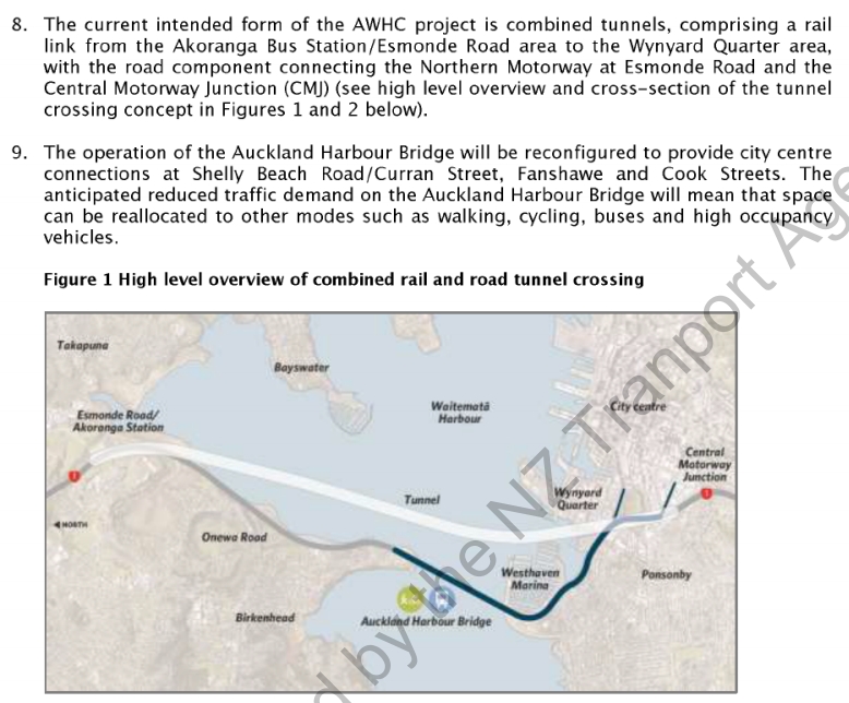
The first briefing is from February 2018 and has quite a traditional NZTA ‘road focused’ feel to it, seeking to push ahead on protecting the route with urgency. What is interesting from it though is that the plan now appears to be a tunnel from Esmonde Rd/Akoranga Station all the way to the Central Motorway Junction. This is to avoid having to do any more reclamation along the foreshore and would mean tunnels about 6km long, almost twice as long as previously planned. However, given the plans would see the existing bridge effectively become ramps only connected to Fanshawe and Cook streets, those from the western North Shore heading past the city would need to use the tunnel and this would likely mean first needing to head north on the motorway to Esmonde or Northcote roads and then doubling back to access the tunnel.
The second of the briefings is far more interesting and is likely responsible for the change in tone of the project. It confirms, with a lot of data, what we have suspected for a long time – that another road crossing is a complete waste of money that either undermines the goals for the city centre or doesn’t actually achieve much. I suspect this is related to the change in purpose noted earlier.
The briefing starts with some of the background information, including historic demands. The graph below is perhaps the most interesting of these, showing what’s happened in car and public transport trips over the past few decades:
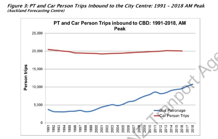
It confirms that over a third (11,000) of the 31,000 people travelling over the harbour bridge in the morning peak are doing so on a bus and increased bus use accounts all of the growth in travel over the bridge during the AM peak since the early 1990s. This also confirms that it’s the approaches to the bridge that are the constraint, not the bridge itself. The paper goes on to highlight that of the 31,000 people crossing the bridge in the morning peak, 14,000 are heading to the city centre while the other 17,000 are heading past it. Delving deeper, of the 14,000 to the city, around 6,000 (42%) are travelling by car with 8,000 (58%) on buses. The other 3,000 on public transport were likely travelling via Ponsonby Rd or on a bus that passed through the city, say to Newmarket (these numbers will be from before the new network launched).
The key part of the briefing are the results of some really interesting transport modelling on a variety of crossing options. The modelling seeks to help answer the following questions
- What if you don’t do anything?
- What if you just built a light-rail crossing?
- What if you build both a light-rail and road crossing?
- What impact does introducing road pricing have on all these options?
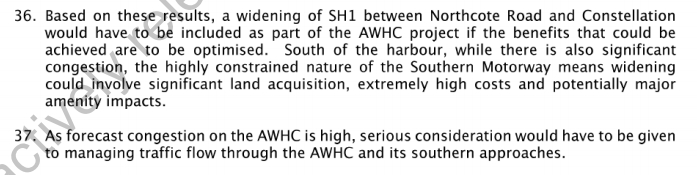
- What impact does widening (or not widening) the northern motorway from Esmonde Road to Constellation Drive have on all these options? It is noted in the briefing that widening the motorway would almost certainly be required.
The graph below shows the current numbers and how they are expected to change over time under the possible different scenarios.
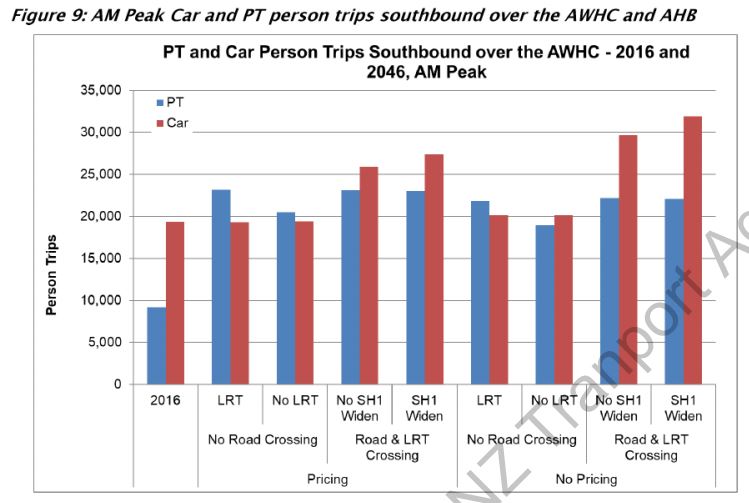
There’s a lot going on in the graph above, but some of the key take-outs for me are:
- Even if you introduce road pricing, building a road crossing still induces around 6,000-8,000 more morning peak car trips.
- If you don’t do road pricing, build a road crossing induces around 10,000-15,000 more morning peak car trips
- Light-rail seems to add around 3,000 morning peak PT trips. This seems quite low and reflects how transport models continue to struggle to simulate public transport capacity issues. It simply isn’t practical that we could more than double the number of buses in the “do nothing” scenario given the constraints on our city streets and that adding that many buses wouldn’t also impact on capacity on the bridge for cars. The NZTA acknowledge this fact in the briefing.
- Building a road crossing doesn’t seem to reduce light-rail ridership.
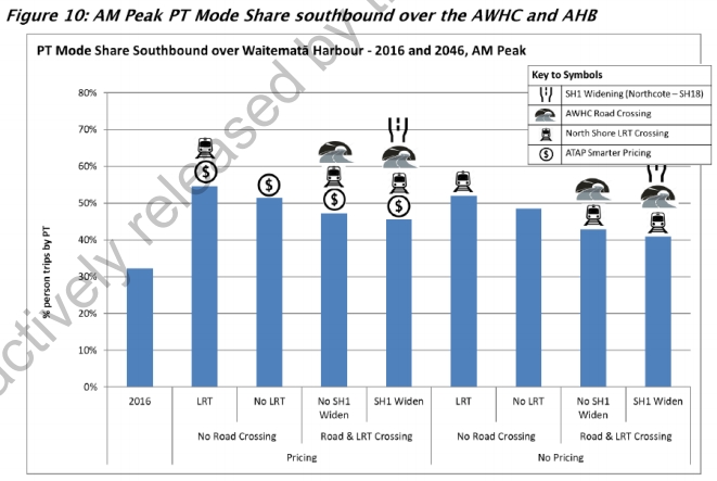
- A future with pricing and light-rail gives the highest “mode share” for public transport – with over half of morning peak trips being made by PT. Even without pricing and a light-rail only crossing you just get over half of trips being made via PT.
The next graph is perhaps the most telling of all, as it compares travel speeds and total vehicle kilometres travelled (VKT) of the different options:

Once again there’s a lot going on here, but let’s focus on the “with pricing” options – given that by the mid-2040s it’s pretty much certain we will have some form of road pricing in place (as a replacement for fuel taxes, if not for anything else). The other thing to remember here is that these vehicle speeds and VKT are across the whole Auckland region, meaning that what looks like relatively small differences between the options are actually likely to be quite noticeable.
- Of the four scenarios, the best-performing in terms of average speed across the transport network seems to be the “road pricing and light-rail only” option.
- This is closely followed by the “do everything option”
- The third best scenario has a road crossing, light-rail and pricing but no widening north of Esmonde Rd
Thinking about this further, I came to the realisation that this is actually a pretty amazing finding – when you compare the first green bar and the third/fourth green bar. Comparing these highlights that basically the roading project does nothing over and above light-rail and road pricing. Those billions of dollars of spend on a massive new motorway tunnel and gigantic widening don’t even speed up traffic at all. In fact it seems that traffic goes slightly slower with the project in place than it does without it. This is not just a project that would have a cost-benefit ratio that struggles to reach 1 (i.e. does it generate enough benefit to justify the investment in it) but rather a cost-benefit ratio that would struggle to reach 0 (does it create any benefit at all?). This is also a point made by the NZTA

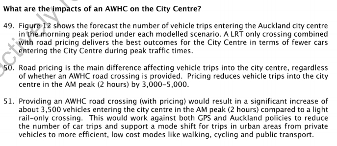
The next graph looks at impacts on the city centre, which highlight once again what a disastrous project the road crossing would be:
Looking first at a situation where there is road pricing, the road crossing induces around 3,500 extra car trips into the city at peak times. Without pricing the result is even worse, with the road crossing inducing 3,000-5,000 more peak car trips into the city centre. Not only is there probably nowhere for these cars to go in the city centre, anything that increases car volumes is completely contradictory to what the Council (and I’m guessing the Government) are trying to achieve.
Overall I think this briefing should put the final nail in the coffin of a road crossing of any form. For a long time we have been saying the crossing is too expensive, will create horrible environmental impacts, will ruin the city centre and won’t even fix congestion, and that we should build a light rail only bridge. The fact that including a road crossing actually makes car travel around all of Auckland slower than a “light-rail only plus road pricing” scenario is just staggering. This project will literally makes things worse for the very people it’s aimed at helping. The current investigation is due to be reported back in the middle of the year, it will be very interesting to see the results of this work.

 Processing...
At least they are no longer even considering a road only option. Really no surprises here. Build a motorway and it will fill with cars. Provide a meaningful PT option and its success will confound the planners
“It’s success wil confound planners”
Road planners and career highway designers that is.
Multi-mode planners who aren’t wedded to a specific mode will see the results they expected.
I know a grey-haired white male road engineer who is the most pro-PT person you’ll find. They also happen to be very pro-lowering the speed limits and can point to research showing that how we rate speeds in general, and corners in particular, tends to favour male drivers based upon overseas studies.
The point (yeah, there was one): Just because one is a traffic engineer, doesn’t make them pro roads. Secondary point: Sterotypes can be harmful to a positive discourse.
relevant. Though i would rephrase:
Roads beget traffic; rail begets people.
*braces self for an onslaught of “BUT WHAT ABOUT HEAVY RAIL” comments*
Presumably from temporarily exhausted anti-1080 campaigners just back from their anti-vax rally.
Will likely be too disruptive to convert the busway into LR considering it is already nearing capacity during peak times. That means that by the time rail is put in place (and with tunneling prices falling relatively to other forms of construction and land prices) it is likely that the whole North Shore will be tunnelled. If tunneling then HR is the better option.
As for Sanctuary – pretty sure that breaches forum rules you self righteous prick.
Also I can’t speak for others but most pro-HR seem to be the opposite of what you suggest regarding anti-vaxx/flat earth etc and quite frankly your suggestion is both insulting, childish and pathetic at the same time.
Way to prove his point dude…
“If tunneling then HR is the better option.”
How does that make sense? If anything; the larger loading gauge that heavy rail would need (even in NZ) would push the price of tunnelling up.
If it’s not going to be convenient to any existing heavy rail and if it’s only going to move people; why would you even consider heavy rail and not instead build something customised?
Agree. If a full tunneled route was a requirement then HR would be the last thing you would chose.
You would use a metro mode, and avoid a large loading gauge forcing big tunnels, avoid grade constraints forcing deep expensive station, and avoid interchangeability with heavy rail not letting you run automatic operation with rolling block signalling.
At the least you’d use LR and skip the grade constraints and deep stations.
Yes for once I completely agree wth you.
I can’t see any need for any future north shore rail to be heavy rail. It’s not going to be shifting freight and it’s not convenient to any existing heavy rail.
The best upgrade for the northern busway would be to a light metro where the system can be customised to requirements (such as being driverless, being standard-gauge, having third rail traction) instead of having to conform to the mainline regulations. And provided it’s future-proofed properly; the light metro could at some stage in the distant future be upgraded to a proper metro.
And I will even go so far as to say that people who are advocating heavy rail to the north shore aren’t very well informed.
. . .unless it can also be justified as a freight route for that revitalised Northland rail freight that Messrs Peters and Jones are hoping for. Don’t rule out that things might swing this way.
By the way, I doubt the difference in tunneling costs for HR and LR is that great.
Dave B – there would still be a large gap to close between Albany or Orewa with the existing Northland line, I really can’t see Northland freight ever using a North Shore line. It would be far more economical to just upgrade the existing North Auckland line.
Unlikely from today’s standpoint I agree. But who knows? If a major new rail route is to be built then perhaps it should be for multi-use, just like our entire roading system (excluding the occasional busway).
Certainly NAL freight sharing the Western Line is not ideal either.
Dave – the problem with multi-use is it generally means less than optimal for each task. Our current HR network has limitations on platform height and distance from track due to freight. This means our EMUs require ramps and also limits the number of doors per carriage, both impacting dwell times.
It’s better to get rid of these limitations on the new routes and build them for their primary purpose, metro the one that is guaranteed to happen, rather than the distant possibility of freight.
Good, can we start on a business case for an LRT bridge tomorrow please?
I think they are starting on the LRT business case to Mangere tomorrow, or maybe the day after???
Apparently the NZTA is in disarray. So you’ll have to be patient for any business cases.
Good thing then that NZTA isn’t the only organisation involved with planning the AWHC 🙂
But yeah, disarray doesn’t begin to describe their state.
I’m looking forward to this being finalised so we can finally start looking at the vic park flyover and cook street offramp. We’ve been hamstrung for years waiting for some decisions on this topic and it was always going to end this way, but at least we (the many thousands of people living along this route!) can move on now!
Encouraging. Now it’d be good if they released the business cases for the LRT to Mangere and North West.
Ditto. How this was allowed to slip is a big black mark against someone’s name.
Excellent post. Can NZTA and their consultants now stop wasting our money on any further work for a road crossing?
And start planning the city centre for a light rail crossing … aren’t there property implications of this? Wasn’t there some weird thing like AT sold NZTA land around Cook St for some tiny amount so that it could be used as part of the road crossing? Can that land now be used for something better? Bus depot with apartments above, with light rail possibilities in future….
The second harbour crossing is to facilitate both reading and light rail.
Ironic
Ironic how?
It’s a fact. This idea that it’s a “road friend” project has no foundation.
Ironic that you accidentally wrote facilitate *reading*, instead of roading.
Perhaps you should do a little reading of your own first! Proof reading would help, if not reading the information above.
Oh okay so the best arguments against me are to find my typos (as my typing was done from my iPad).
I really expected something more on the actual topic…
I look forward to one day reading whilst on light rail going across (under or over) the Waitemata. Maybe just one day this may happen 🙂
There are already two harbour crossings. The *third is unplanned, unconsented, and unfunded. It *could* include roading and rail, or (as described at length in the blog post you are commenting on) we could save ourselves $4b and just build LRT.
The land was indeed sold by AT to NZTA – it’s the AMA (Auckland Motorway Alliance) site at the corner of Union and Cook between the motorway and the Placemakers site.
The original ‘vision’ in the City Centre Master Plan was for the offramp to follow the motorway up the hill, not into the city. I don’t think that will ever come to pass, but the AMA use does seem to preclude the planned park and development on the Placemakers site.
Oh yeah. A real “nail in the coffin”. Interesting how what the NZTA (whom yesterday were being described as “in disarray”) has to say suddenly is held up as authoritative when it’s presented and interpreted a certain way to confirm people’s biases.
Once again: The Nippon clip-ons cannot remain on the Auckland harbour bridge indefinitely. This is an elephant in the room that mysteriously keeps being avoided.
I guarantee: This is not the end of the next harbour crossing, the project will resurface and one day be built. I do not have the same expectations for this light rail to the airport.
Doesn’t look like the NZTA are too concerned about the clip-ons anymore, it’s increasingly looking like you are the only one that thinks they are an issue.
“Doesn’t look like the NZTA are too concerned about the clip-ons anymore”
So has this highly inefficient and hilarious practice of monitoring and maintaining them ceased?
No, they are still doing it, it’s probably how they have reached the determination that their lifespan is not an issue anymore.
I can’t comment on whether it is hilarious and inefficient though as I don’t know whether they use the most efficient process for monitoring and maintaining a bridge or not or how much time they spend laughing while they are doing the job.
Do you really not see anything untoward about the level on maintenance and monitoring that the clip-ons need?
Bridges around the world are monitored and maintained. But nowhere near to that degree.
I guess it will be you and not me who’s surprised if there’s a sudden announcement at anytime that the southbound clip-on is being closed to traffic…
Do you have any data on what this supposedly ‘untoward’ level of maintenance and monitoring actually involves?
Because I did hear that the brand new waterview tunnel requires $30m a year for opex. One can only assume a third harbour motorway tunnel would cost at least that.
How does that compare to the opex on the harbour bridge?
I agree there is a large amount of maintenance involved, but that doesn’t mean it is inefficient or that the bridge poses an untoward risk as long as that maintenance and monitoring continues.
While it might be expensive, the large cost of building a new tunnel and even operating an new tunnel once it is running means the cost of maintenance and monitoring is very efficient.
‘I guess it will be you and not me who’s surprised if there’s a sudden announcement at anytime that the southbound clip-on is being closed to traffic…’
Well that’s reasonably obvious, given I don’t anticipate an announcement like this of course I would be surprised.
Sorry Jezza but all the maintenance is doing is delaying the inevitable. At some stage; there’s going to be a point where something that cannot be replaced is going to be too weakened (such as the actual points of attachment).
I refer to my original comment:
‘Doesn’t look like the NZTA are too concerned about the clip-ons anymore, it’s increasingly looking like you are the only one that thinks they are an issue.’
NZTA have previously advised that by managing heavy freight movements (eg: the Western Ring Route), the “clip-on’s” have an indefinitive service life.
Excellent post, thanks Matt.
It is a legal requirement that any bridge used by the public is subject to routine inspections by qualified persons, and that they are maintained to ensure continueing safety. Even simple footbridges in remote locations. Nothing highly inefficient or hilarious about it, unless of course, you have a very very unusual sense of both prudence, and humour.
The amount of monitoring and maintenance in the Auckland harbour bridge is an awful lot more than any other bridge.
Regular maintenance led to a condition that was assessed to be in danger of a catestrophic failure 15-20 years ago.
What are your sources? Any expertise in this area?
Your the one making the claim, so as someone said in another comment below:
“the burden of proof is upon you” …
Wasn’t the life of the bridge basically indefinite if heavy traffic didn’t use the clip-ons? Hasn’t his already been done to death?
Also, why are there so many people obsessed with having multiple ways to access the same bit of the North Shore while the rest of the city can barely get a busway?
The actual bridge has a long life.
The clip-ons do NOT. They’re going to have to come off at some future time.
I’m getting the impression that some people are trying to pretend otherwise.
Can you provide some sort of link?
You’re the one who’s made the claim that something that’s attached by brackets and thru-bolts has an indefinite life. Especially something that already requires an extensive monitoring and maintenance program.
So the burden of proof is upon you, not me.
Yawn. The NZTA claimed the indefinite life with proper management, we showed you the page on their website already… your turn to provide evidence to the contrary.
Hahahaha no you didn’t Nick R
You showed me a website which said no such thing whatsoever. And which couldn’t be construed as such in any way.
Go on: Link it again. 🙂
Meh, I don’t really care whether you accept it or not. Up to you.
Daniel: I’m quite happy to say I am not an engineer, although my wallet probably wishes I were, and I have no real understanding of the physics of bridges. As you point out , the website discusses the Bridge and not specifically the clip-ons. Can you point me to something that discussed the clip-ons as you have? I’m not trying to win internet argument points, I’m legitimately asking for a source so I can go and have a read.
Buttwizard, the following two links may be of interest.
The first might get a bit technical in places depending on your background, the second one is the general history of the bridge. I found them interesting, anway …
Auckland Harbour Bridge Box Girder Strengthening Design: http://www.cmnzl.co.nz/assets/sm/3605/61/1100-1125Pank.pdf
Auckland Harbour Bridge (EngineeringNZ):
https://www.engineeringnz.org/our-work/heritage/heritage-records/auckland-harbour-bridge/
Couldn’t they just replace the clipons with new ones then? I don’t see why that would require a whole new crossing…
Nope replacing the clip-ons is impossible. They’re essentially attached with thru-bolts. You only get to do that once.
And the clip-ons were horrendously expensive the first time anyway, they cost considerably more than building the original bridge 8 lanes would’ve been.
Actually no. If you calculate the net present value back to opening day, it was significantly cheaper to widen the bridge to eight lanes after the first ten years, than it would have been to borrow the extra money required to build the first proposed six lane bridge from day one.
So cheaper, and you got eight lanes instead of six. Good strategy.
Just to clarify, the “clip-on’s” are NOT clipped on to the main bridge. They are attached only to the bridge’s concrete pylons (the foundations under the bridge).
If the method of attaching the steel cantilever brackets of the clip-ons to the concrete of the piers is subject to failure (and that has not been demonstrated) it seems to be relatively straight-forward to devise several alternative methods to transmit forces from the steel columns of the clip-ons to the concrete piers and devise methodologies to do it without closing off the clip-ons to traffic.
As an extreme solution to the ‘bracket problem’ why not just widen the concrete pylons all the way up from the sea bed to under the clipons? Sounds extreme, and no doubt there are simpler solutions, but surely cheaper than rebuilding the whole thing or a new tunnel.
Or just use piles like any other cheap and simple bridge in the world.
By Nick R:
“If you calculate the net present value back to opening day, it was significantly cheaper to widen the bridge to eight lanes after the first ten years, than it would have been to borrow the extra money required to build the first proposed six lane bridge from day one.”
Let’s see what a parliamentary debate in 1965 between the minister of works P.B. Allen and the shadow minister Hugh Watt (I’m sure most Aucklanders are familiar with that man) about the extension had to say about that now shall we? It begins at page 2328:
https://books.google.com.au/books?id=-vVH-Rga_YoC&pg=PA2330&lpg=PA2330&dq=cost+auckland+harbour+bridge+extensions&source=bl&ots=mGIOVi51Ry&sig=ACfU3U0Z_SDjPj56xJo67cLcSNzf5DwXiQ&hl=en&sa=X&ved=2ahUKEwjztPTije3gAhWFV30KHcFnDQo4ChDoATAJegQIARAB#v=onepage&q=cost%20auckland%20harbour%20bridge%20extensions&f=false
In particular this from Watt:
“The Government of the day, a National government, decided that we could not afford a 6 lane bridge and that it should be reduced to 4 lanes. That decision saved about £600,000… …We said £600,000 in 1950 by deleting two lanes from the bridge. Today we propose to spend £6.25 million to put those two lanes back and two more besides.
Now to be fair: The original bridge went about twice over budget, so it’s fair to estimate that a 6 lane bridge would’ve cost more like an extra £1.2 million pounds.
However as I understand it; the clip-ons eventually cost more along the lines £10 million. I can’t find a source though and I don’t really have enough time until the weekend to dig deeper.
But really: What does anyone with any physical intuition expect?
The clip-ons had to be fabricated in Japan, Shipped all the way to Auckland, and then attached from ships to brackets (thru-bolted into the concrete foundations) by expert Japanese crews. Or course that was the obscenely expensive way to do it! It was done this way out of desperate necessity, not out of any ingenuity! If it’s cheaper to thru-bolt brackets to bridge foundations and then use them as an attaching point for more lanes then why have hardly any other bridges in the world ever also had it done?
Was it 1984 that the toll booths were finally removed?
I don’t think I’m being out line when I declare that this Nick R is talking complete twaddle with this insinuation that this was some wise master stroke. “Good strategy” my bottom.
It was a total balls-up from a completely incompetent, to the point of ineptitude, Minister of Works (Bill Sullivan) that the nation had to later borrow many times more money that he imagined he’d saved to fix it.
Ha right, “physical intuition”. I’ll try that on with my clients, see how far my feels go. “I’m getting a really strong vibe that I’m right here”.
If you are going to accuse people of twaddle, you might want to avoid it yourself.
Anyway, the clip ons cost $7.4m in 1969 dollars. The difference between the four lane bridge and the six lane bridge was 1.6m pounds in 1959 pounds. If Auckland had borrowed an extra 1.6m in 1959, on top of the cost of the four lane bridge, after ten years of interest the total cost of that borrowing would have been 2.87m in 1959 pounds. Converting that to 1969 dollars according to the the CPI conversion from the reserve bank, gets you…. $7.9m in 1969 dollars.
So yes, spending money to widening the bridge to eight lanes after ten years cost the city less than borrowing extra money on day one to build a six lane bridge and paying ten years of interest.
Let’s see shall we?
Here’s the reserve bank of NZ’s inflation calculator:
https://www.rbnz.govt.nz/monetary-policy/inflation-calculator
I put in 600000 (I don’t know where on this earth you get £1,600,000 from) in the calculator for Q1 1949 (it’s in dollars and not pounds, but still) to calculate for Q4 1969….
…and I get…
…$2,723,571.43.
And the fact that the clip-ons were ore expensive than making the bridge even 8 lanes to begin with was widely known around NZ for a few decades. I remember being told this by an awful lot of adults back in the 80’s and early 90’s.
Physical institution means appreciating how much extra arseache and cost having the clip-ons manufactured in Japan, bolting the pier extensions, shipping the clip-ons all the way to NZ and getting expert crews to erect them (instead of building it 6 or even 8 lanes from the start) is.
To repeat: hardly any other bridges in the world have gone to this measure.
I could’ve said common sense instead of physical intuition….
Oh and as for the final cost of adding the clip-ons; here’s some more from Percy Allen in Parliament this time from 1969 (page 1469):
https://babel.hathitrust.org/cgi/pt?id=uc1.b2940067;view=1up;seq=591
“It is expected that the total cost of the additions to the Auckland Harbour bridge will be about $16,365,000”
Did you get this figure of “$7.4m in 1969 dollars” form the same place as this “1.6m pounds in 1959 pounds”?
I’ll let anyone else cast their own judgement upon someone who imagines that this sort of obscene expenditure waste was a “good strategy”…
Cheers for all that info Daniel, lets jump in the Delorean back to the 60’s and sort this mess out..where we are going, we don’t need roads (or a Bridge)
The Clipons are there, I know this because I drove over one of them last night. So until they are gone, which nobody has seen anything planned thus far to get rid of them, inflation calculators and the like are completely irrelevant.
Incredible.
Nick R makes a completely outrageous assertion (that the clip ons were a “good strategy” and “cheap”, based upon fantasy appreciations of their cost and not what they are the desperate outcome of a disastrous lack of foresight) and I call him out on it.
And this Joe guy not only completely misses the point but rather than ridicule the person deserved of it, he somehow ridicules me (posting guidelines anyone?).
Well actually Joe; the clip-ons were not intended to be a permanent thing to begin with. The entire second crossing was about ridding the AHB of them. So there were plans to get rid of them. Somewhere in recent years the necessity to get rid of them has amazingly been forgotten.
No need to thank me for setting you straight with the truth.
It’s important to understand the ways in which these modelling outputs almost certainly underplay the outcome above. Here’s a couple:
1) As Matt says above our transport models hate PT, especially any PT with steel wheels, it seems the assumptions buried in them always mean the output under predicts actual, significantly.
2) There seem to be zero spatial limitations at destinations for car and buses, an infinity of either can be sent to clearly finite and full places like the city centre and the daft model doesn’t bat an eyelid (15k extra cars in the city centre: Tui Billboard).
If our transport models say a road is stupid, it has to be really really stupid, road projects have very low bars to cross.
This one is dead.
NZTA are refusing to pay SkyPath for the work they’ve done cos they mightn’t use it: will they now not pay the big engineering consultancies that have been designing this diplodocus for years and years?, cos the road version ain’t happening….
Thing is Daniel the two posts are deeply related; what we are seeing is an organisation trying to enter, belatedly, the 21st century. It is clearly suffering from cognitive dissonance, deeply held beliefs are having to be reevaluated, changed up, and this can be just as difficult a thing in organisations as in individuals.
Change is hard, transformation is extremely difficult, and usually takes an entire generation.
Old saying: ‘science moves on one death at a time’.
Exactly what do you know about the NZTA beyond speculation?
I doubt you’ve ever worked for them. Have you ever dealt with them in a professional capacity?
I can’t speak for Patrick but I have dealt with NZTA in a professional capacity and have worked with many other people who also have. The Agency is very siloed, held back by its own bureaucracy and struggling to change. It’s “completely dysfunctional” in the words of my ex-boss who has been working in the road construction sector since before NZTA existed.
This is not to say that the individuals working for NZTA are useless, far from it. Some of them are experts at what they do. Some of them have innovative and progressive ideas. I once worked with an elderly NZTA manager who thought public transport should be free (100% subsidised). Unfortunately his silo is some state highways in the South Island so he has no influence over what goes on in Auckland.
So NZTA can be completely dysfunctional and still produce some good work. But that doesn’t mean that it’s making the best use of its resources or that everything it does is in the long term best interests of NZ.
The best answer would be a low bridge with space for four light rail tracks, two bus lanes (yes it isn’t worth making some people change) and wide cycle lanes and a footpath. They could give the tenants at Westhaven marina 10 years notice of the new height limit so those with yachts could bugger off. That just leaves Chelsea sugar and the Navy bomb store. Chelsea should be in an industrial area already and quite honestly what the hell are the navy thinking taking explosives up the harbour to store? Haven’t they heard of Halifax?
This reminds me of something I noticed with the Adelaide 500, which is held about 15 minutes walk from the Adelaide CBD. Whereas in Auckland, we seem determined to drive everything that doesn’t happen in an office block from a 10km radius from the Skytower.
Any yacht that can berth in Westhaven marina is pretty small (10 to 12m LOA mostly, even on the end the max is 24m LOA) the mast height isn’t an issue.
No reason why a new bridge for LR, buses etc couldn’t have the same clearance as the existing bridge, then you have no problems for westhaven, chelsea or the naval store.
The existing bridge was designed to its current height so cargo ships could go under it to a new port proposed at Pollen Island. That port was never built and never will be. (Cargo ships are now far to big to go under the bridge anyway.) Using a previous mistake as the design standard means throwing good money after bad, it means having steeper approaches than are necessary and it means fewer cyclists will use it than if it were nearly flat. But worse than the height is the width of centre span which can also be much smaller if the bridge isn’t designed for 1950’s cargo ships.
Best of all is a lower bridge would simply be an asset for people who just want to go for a walk and see the water up close.
I’m wary of a lower bridge because I’d prefer our city to remain as the City of Sails. The upper harbour is really cool to explore if you can find a boatie offering a spot. However, perhaps what is really needed to retain priority on the water for people in modest sailing dinghies and rowing skiffs and canoes, etc, is not a higher bridge, but proper enforcement of safer speeds on the water. 🙂 I can’t believe they allowed those super fast racing motorboats.
From an aesthetic viewpoint, generally following the curve of the existing bridge for the middle half would be the best option. The 1/4 at each end isn’t so relevant.
🙂
+1 to miffy’s comments, and as you may be able to guess, I’m an avid boatie. The existing bridge has 42m of clearance. That is beyond what is needed for the vast majority of boats. I could see a justification to build a 20m clearance to allow most cruisers up the harbour, but there is no reason to go so high again.
The new LRT and a walking and cycling path should run right next to the motorway to the base of the bridge, on a viaduct if necessary. The new bridge would then match the existing bridge’s profile, but be stretched in the x direction and compressed in the y-direction to make the span to wynyard and a 20m clearance. You’d have walking and cycling on the bottom tier, with LRT and buses above. I don’t think you would need four LRT tracks, but the bridge could be built strong enough for a third tier in future (maybe the northern busway will be driverless and Onewa Road would be regulation LRT?).
I really hate this idea of essentially adding to the width of the current bridge. If we are to build another bridge, and I think we should certainly consider it, it should be on its own alignment. We have one pretty ugly bridge; let’s put put a beautiful bridge in front of it, but away enough from it to maintain its own form.
Any new crossing should be as direct as possible, and from Wynyard Pt to the old toll booth area would be sweet for a Transit and Active mode crossing. The views would be fabulous, the speed so attractive between the city and the Shore it would be beyond competitive with driving.
Personally I think a modern graceful cable-stay or similar structure would grace the Waitemata and be an addition to the city and its experience. However there are issues to work through such as impacts on the Wynyard park and at the Shore end.
Height doesn’t bother me much, there’s enough length to gain a similar elevation if needed, though a flatter form is my preference.
If this is too much for Aucklanders then tunnels will do, but I think we’ll miss a trick to create a beautiful new thing and an new way for more people to experience this city’s greatest asset.
I’m not sure where you got the idea that I was adding to the width of the existing bridge, especially given that I said that the bridge should land in Wynyard Quarter.
If you went parallel to the motorway all the way to the toll booth, you’d go the extra 300m to the base of the bridge, so that the motorway would curve away from the new bridge, which would point directly at the city centre.
They most certainly have heard of Halifax and know that it cannot happen here. The SS Mont-Blanc had almost a frigate’s weight of explosives on board not the couple of hundred shells, dozen or so torpedoes, and eight missiles that an ANZAC class frigate is armed with. The explosives are also safer, stored better, and located inside an armoured warship not some tramp steamer that was never designed to dangerous cargo. There’s also no real alternative to Kauri Point available, the harbour has been built out already except at Kauri Point for just this purpose. The odds of any explosion occurring are minuscule and even if one did occur there’s not enough explosive material on board our ships to cause anywhere near the amount of damage that the Halifax explosion caused.
They thought it couldn’t happen in Halifax. But to address your points, the Meko200 ships are not armoured in the traditional sense of belt and deck armour, they are low end steel frigates built to be light and cheap. They are intended to rely on active defensive measures although not always fitted. The Navy’s store is built to hold a hell of a lot more than you suggest. The fact they don’t need a lot in peacetime for a low end frigate isn’t the point.
The point is they plan for unloading explosives from a large ship in a built up area to put them onto smaller ships to take up the harbour. They certainly didn’t set up this system to then require one of their two frigates for all delivery duties. I agree with you about the quantity- but it is still a really dumb way to plan on handing explosives in that way. Lucky they dont need a resource consent because you would never get one for it. As for alternatives I don’t think anywhere in the inner harbour should be considered. Great Barrier would make more sense.
Why is the current system like this? There are two answers to that, 1/ it has always been this way and 2/ Kids who are smart don’t join the navy.
“Great Barrier would make more sense.”
How about Rangitoto. I understand that it is no stranger to explosions.
I’d agree a lower bridge would be better for active modes…then again view from higher up? Anyway, surely we could have it a little lower gradient than the current bridge & still have quite good clearance?
Hold on you guys – this is a historic occasion! I think we just witnessed a perfectly serious and useful comment from Miffy. That doesn’t happen often (or at all? Is this a first ?) and I think we should take a moment to celebrate.
Or have I been sucked into an endless pit of cynicism?
It happens regularly -once every fourteen years.
I’d much rather the walking/cycling provision be made on the current bridge rather than a new crossing that will inevitably spring from a point further north. A very long crossing will hardly get used by pedestrians, so there’s not much point. For cyclists starting their journey south of that springing point then heading north to get to a crossing going south is an impediment, for everyone else it wouldn’t matter if their journey south was at ground level rather than on the start of a long bridge. That’s what Skypath / Seapth is all about, maximising access.
If they could somehow be allowed to drop all this effort into the extra general traffic bridge & put it into SkyPath, it would be built by now.
After reading the CRL Facebook page they showed a TBM arriving in Sydney why can’t the NZTA get it from them after they have bored the rail tunnel under their harbour and use it here for the same purpose ? . By that time the LRT should be stared/complete ? if the NZTA get off their chuff’s and stop writing forest after forest of reports and just do it and use the Super Fund ‘s money that way they won’t be out of pocket
Then the light rail could extend from the airport through to say Albany/Orewa . Instead of just terminating at the Wynyard Quarter
There’s an old rusting TBM at the western entrance to the Kaimai tunnel, which is even closer than Sydney. We could just use that one, it would be about as useful.
That one would be ideal for the Waitakeri as the one in Sydney is designed for the same material we have under our harbour i.e sandstone and with both it may mean just puttind new cutter heads on them
The TBM would have to be sent back to the manufacturer for new cutter heads, which make up most of the cost of the TBM anyway. It would make more sense to just order a TBM for the project when we want it, it wouldn’t cost any more.
I can’t believe no one has mentioned the one thing that really stands out from the map of proposed harbor crossing: Devonport. A big bridge from the top of North Head, straight over to Parnell. Job done. No more worries about your strap-ons.
way ahead of ya:
https://www.greaterauckland.org.nz/2015/06/19/the-devonport-parnell-bridge/
Excellent – thank you Patrick! So, the designer of the Sydney Harbour Bridge had already designed us a second crossing. I was just looking at the Sydney bridge the other day – it is a stunningly beautiful thing really, isn’t it? Ours just looks a bit limp and pathetic by comparison.
There was a postwar scheme too, motorway all the way up through Devo! elevated, across bays, a real charmer… I can’t find the images right now, all nicely hand drawn of course, and deadly serious…. extraordinary to try to imagine now…
Read the book “Tunnel Vision” first edition by Martin Butler. That will kill your idea there and then.
Been picked up by Stuff:
https://www.stuff.co.nz/auckland/111053915/light-rail-tunnel-under-auckland-harbour-could-be-best-option-to-cut-traffic-report-says
And interest: https://www.interest.co.nz/news/98495/new-harbour-tunnel-tackle-aucklands-traffic-congestion-back-agenda%C2%A0%C2%A0
So there are over 10,000 people who will want to cross the harbour at peak, but won’t if the road crossing isn’t built? (8,000 if you charge them). Bad luck for them I guess. Maybe they can buy an apartment in town and their kids can walk to the Domain to play (assuming the Council hasn’t sold it off to pay for the massive cost blowout on the CRL).
Actually… yes.
It may be much cheaper to upgrade the streets and public spaces in central areas so they can support more people living close-by. Then, as for your example, kids don’t need to walk all the way to some big park (it will probably be Myers Park and Victoria Park) to play outside — in both cases right now this is often a long and dangerous walk.
Kid-friendly apartments do exist overseas. To anyone who is unable to drive a car for whatever reason such apartments will be a godsend.
Maybe they can buy an apartment, good call! Or maybe they can live in Central or Eastern, Western or Southern suburb like 80% or so of Auckland, with great PT connections…or maybe they can stay right where they are and take the LRT over like the massively growing numbers of people who are taking PT over the bridge now do (if you’d read the article – PT trips risen, driving remained same for 20 years)…or drive to their job and rightfully sit in traffic and pay for it.
By the time the crossing is made in 20 years or so, do you really think we are going to living, working and travelling as we are today?? Living on a North Shore quarter acre and jumping in your SUV to go to work? Have you even heard of the Access for Everyone plan for the City Centre? Change is coming i’m afraid, although the demographic that fear change the most will most likely not be travelling to work over the bridge in 20 years time but in the midst of their retirement.
Well properly understood it reads as: the model predicts the 6 additional traffic lanes will induce 10 000 car drivers to try to enter the city…. they can’t so, it won’t, but the model is too dumb to see that.
Road and light rail tunnels plus motorway widening will be more than twice the cost of light rail tunnels alone. Is spending more than 100% more really justified to increase trips by 50% in peak?
Besides you haven’t demonstrated any loss of quality of life. Those people could not live on the Shore, or work closer to home, or commute outside of peak times, or commute by light rail… There are a multitude of options. 2046 is a long time away so people have plenty of time to organise their lives the way that suits them best.
This is a very narrow road network only analysis remember. There’s absolutely nothing about the other issues with more people driving; health or environmental externalities, land loss from massive interchanges, deaths and injuries… etc etc
And as others have mentioned the fact that there is literally nowhere for these cars to go….
I must have had a premonition because this is the OIA request that I sent to NZTA earlier in the week. I was hoping to discover just how economically sensible it has been to add more roading rather than pursue public transport options.
“Please advise the total spending that has occurred on the Northern motorway between the Harbour Bridge and Oteha Valley Road for the period 2010 to current for:
1) Building additional road traffic lanes or other infrastructure
2) Repairing additional road traffic lanes or infrastructure
3) Planning or administration costs relating to the above
4) Building additional bus lanes (bus way) or other infrastructure related to this
5) Repairing existing bus lanes or other infrastructure related to this
6) Planning or administration costs relating to the above”
It will still be interesting to see what comes back.
Hey Matt, that graph of 2016-2046 changes show a lot more than what you’ve said of 3,000 extra PT trips if LRT is built. Looks more like from 9,000 -> 23,000 in the morning peak if LRT is built and road pricing.
Yes it is a lot of growth compared to now but not compared to do nothing, which is what it should be assessed against. Of course as mentioned, the do nothing assumes unlimited capacity for more buses even though city streets are already at capacity.
If we have indeed seen the death of the Additional Waitemata Harbour Crossing project this is a great day for the Shore, Auckland and NZ. First it represents the saving of about 3 billion dollars. Second, it allows a way forward to genuinely reduce carbon emissions in this part of Auckland.
For me the building of North Shore rail should start tomorrow. With ridership on the Northern busway at the same level as the most successful train route it makes sense to build a provision for substantial further growth. Given that the completion of the project will be in seven to ten years time this will roughly correspond with strong requirements for emissions reduction in terms of out international and Carbon Zero commitments.
It seems that it would be financially more sensible to build the Northern bus way extension as light rail rather than do the project twice. I am no engineer but it seems logical to start at this end rather than the other in terms of minimising disruption.
Given the scale and risk of the proposal compared to recent motorway projects, I think you could probably triple that $3b estimate…
Big step forward in thinking hopefully one that will be followed up with action (or at least something more dynamic than the current dithering). I have talked with an ex-colleague of mine – we both worked for NZTA at the time – about the possibility of running an LRT tunnel to Esmond or Smales Farm via Devonport thus providing an alternative to Lake Road or ferry.
How many different transport solutions does Devonport need?
This paragraph from the following Document states the following :-
https://www.engineeringnz.org/our-work/heritage/heritage-records/auckland-harbour-bridge/
“Despite these fatigue problems, an interesting facet of the bridge was highlighted in a design study done on the clip-ons by the Ministry of Works and Development on behalf of the Auckland Regional Authority. This study determined that there is capacity on each of the clip-on bridges to carry a light rail line as well as two lanes of light traffic. Heavy lorry and bus traffic would then use the main centre bridge”
So it looks like the Ministry of Works had better idea’s than the clowns at the NZTA ,so bring back the MOW and then things might happen .
Newshub tonight had an item on the tunnel under the Harbour tonight and Tywford has to NZTA to produce a report to get it up and running
And the Herald has this today ;-
” Three separate transport options have been outlined in an NZTA report but even if one is decided upon, work won’t start until the 2030s.
• Build a tunnel for light rail only.
• Build a tunnel for light rail and road access.
• Or, do nothing.
The report goes on to say when discussing the three options that there was no inclusion of heavy vehicle restrictions but added restrictions would likely be added in the future to manage the longevity of the harbour bridge.
Indications from NZTA in 2018 suggested a restriction of 35 tonnes was a possible scenario, but not set in stone.:
https://www.nzherald.co.nz/nz/news/article.cfm?c_id=1&objectid=12210646
And this is the Newshub item :-
https://www.newshub.co.nz/home/politics/2019/03/new-zealand-transport-agency-proposes-three-scenarios-for-auckland-harbour-crossing.html
https://www.nzherald.co.nz/nz/news/article.cfm?c_id=1&objectid=12210993