This is a guest post by Nicolas Reid, Technical Director – Public Transport and Rapid Transit at MRCagney and author of Transit By Design, outlining a proposal for the next Waitematā Harbour crossing. It is shared by kind permission (via LinkedIn), with some very tasty bonus images.
The proposal in this post strikes us smart, affordable, deliverable, and delightful. A multi-modal bridge, designed to complement the existing one, enabling freedom of movement for all kinds of journeys. A brilliant bridge like this – built beautifully – would be an iconic addition to our great harbour city.
We’re keen for your thoughts. As Patrick highlighted yesterday, Aucklanders deserve a real say on our next harbour crossing. It’s our chance to solve the real problems, and avoid repeating failed patterns. It’s also an opportunity to shape our city for the better, especially given upcoming conversations around the 30-year Integrated Transport Plan! Stay tuned for more on this timely and exciting topic.
Should Auckland build a Waitematā Bridge for its next harbour crossing?
Nicolas Reid
In this post I present a plan for the Waitematā Harbour Bridge, a multi-modal bridge across the inner harbour east of the existing Auckland Harbour Bridge. A second bridge delivers the huge benefits of an additional crossing aimed at the currrently missing functionality, deliverable at a much-reduced cost and within a much shorter time-frame than previous tunnel proposals.
The Additional Waitematā Harbour Crossing project is in the news again, in the lead-up to officials seeing the latest from twenty-three years of reports and plans for the mega-project. Cabinet will shortly consider a business case, which will undoubtedly present something similar to the designs for extensive motorway tunnels that have been put forward every couple of years since the 2003 report.
Meanwhile the mayor is asking some sensible questions about costs, benefits and time-frames, and presenting some less than sensible alternatives, as various other weird and wonderful schemes are coming to light. So, I thought I would throw my submission from a couple years ago into the ring too.
As a life-long North Shore resident and cross harbour commuter, I’ve experienced first hand a long succession of developments on the harbour corridor through northern motorway widening and through Saint Marys Bay, interchange upgrades on both sides of the harbour, the Victoria Park Tunnel, plus the growth of the first bus shoulder lanes and bus stations followed by stages of busway expansion.
I’ll jump straight in to describe the proposal for now, and follow through with details on the reasoning and analysis in a later article for those that are interested.
The Waitematā Bridge in a nutshell
The proposal is for a new six-lane bridge across the harbour, designed to work in conjunction with the existing harbour bridge to separate motorway and local traffic, while also adding rapid transit and bus lanes, and walking and cycling paths.
It’s aimed at adding the missing modes while also adding missing counter-peak capacity to the state highway. The plan balances the lanes either side of the harbour and separates city commuter traffic from motorway through-traffic, providing resilience and the ability to manage lane closures better.
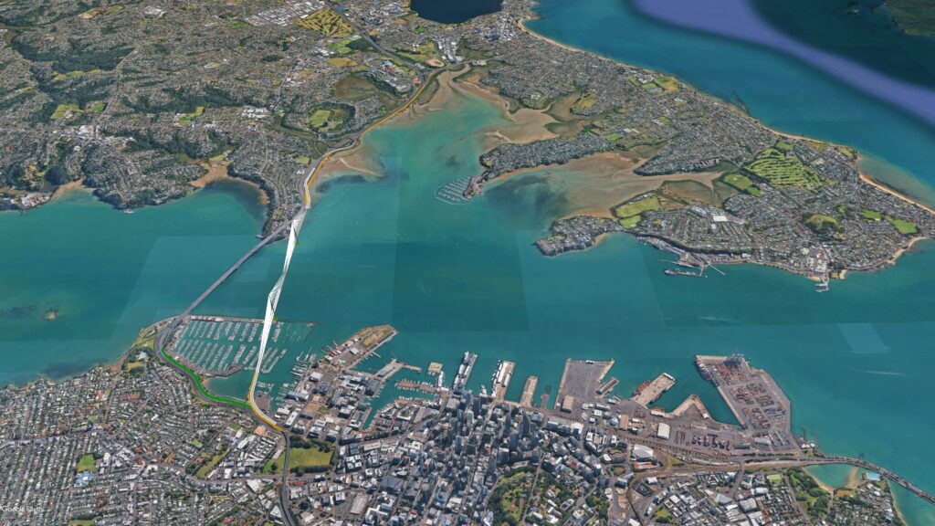
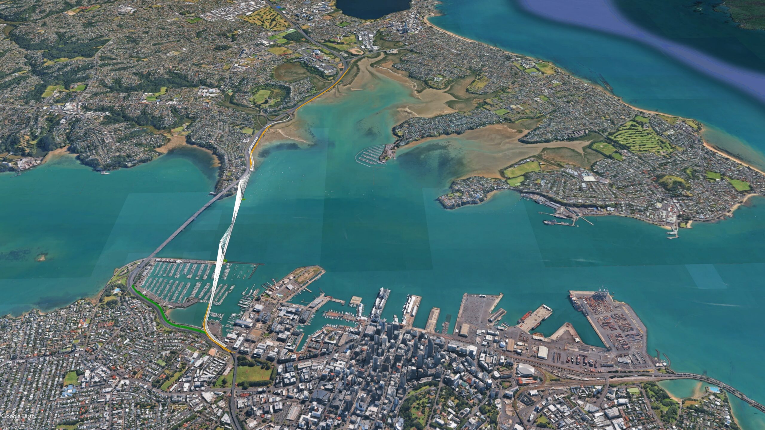
The Waitematā Bridge alignment. Image: Nicolas Reid/ MRCagney
All up, across the two harbour bridges there would be eight dedicated motorway lanes and two dedicated city traffic lanes, plus a pair of bus lanes from Onewa Road to town. This would match the current twelve lanes that already exist either side of the harbour. It would also add a new separate pair of rapid transit lanes to extend the Northern Busway to the city centre, and walking and cycling lanes to connect the active transport network either side of the harbour.
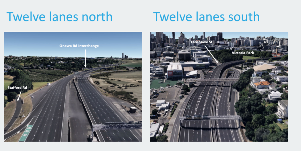
Unrealised capacity, with twelve traffic and bus lanes either side of the eight-lane existing harbour bridge. Image: Nicolas Reid/ MRCagney
The bridge main works
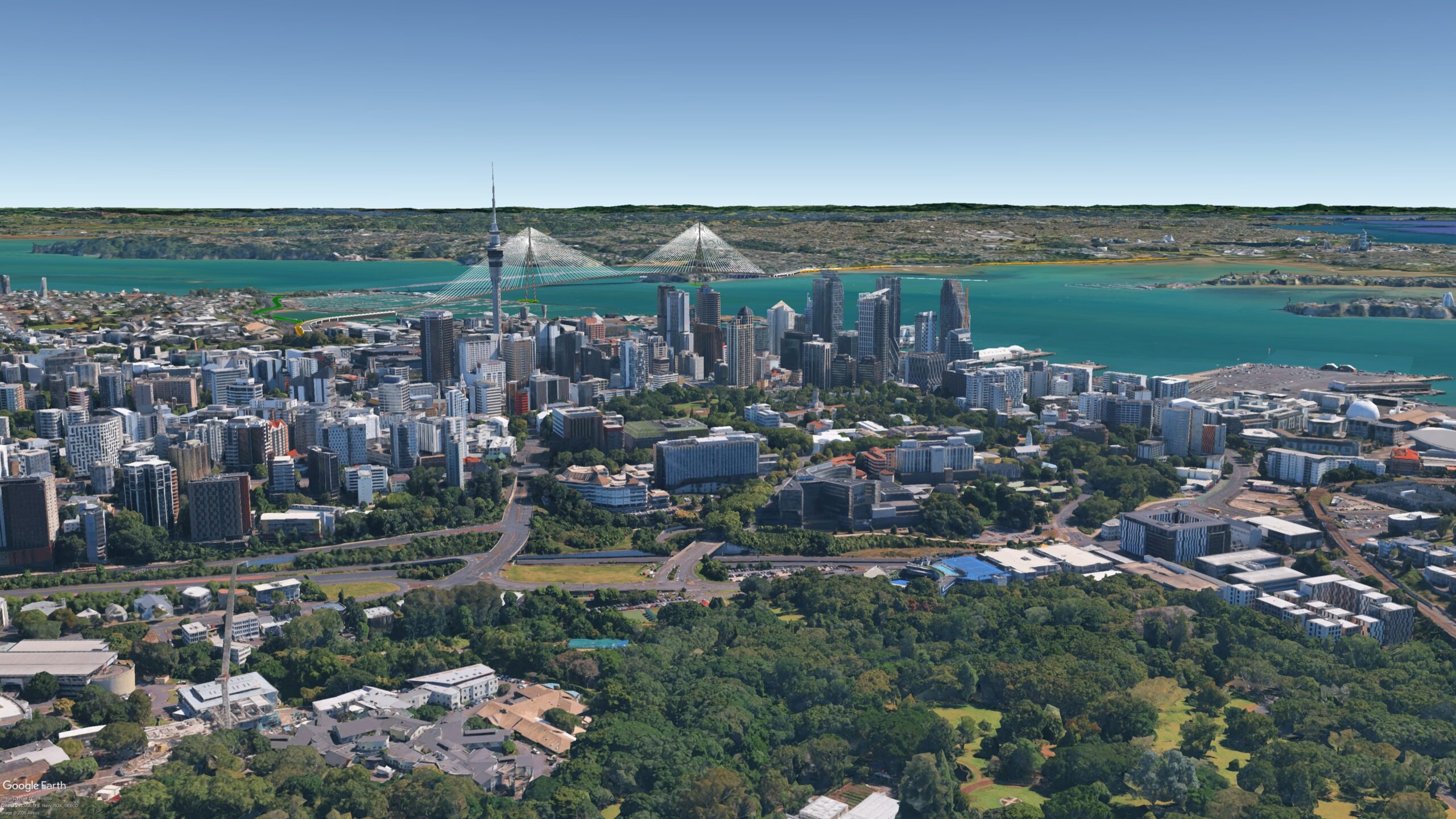
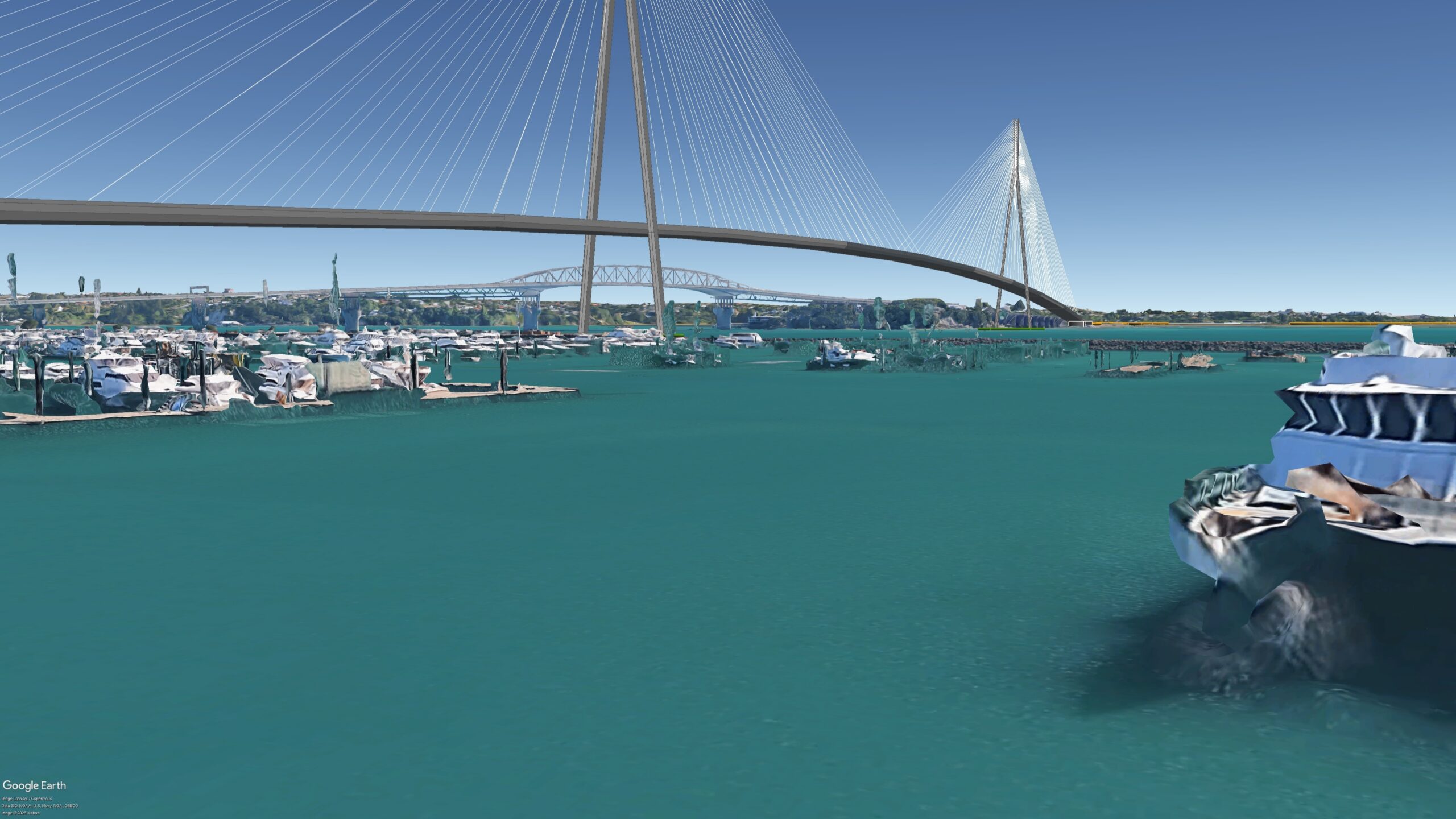
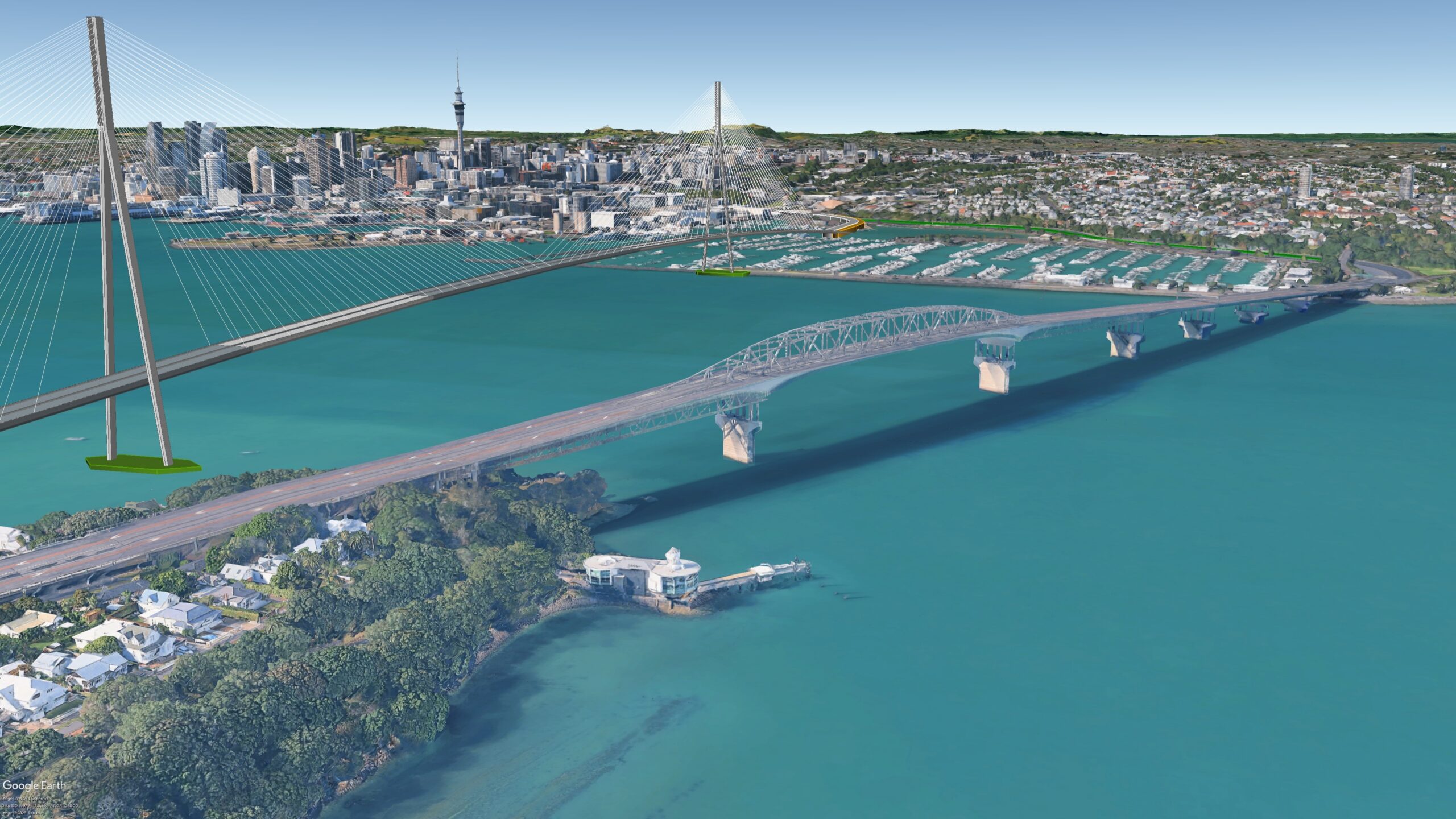
The main structure is a cable-stabled bridge, 1,800 to 2,000m long itself with 3 to 500m approach viaducts either side. The main deck would be around 38m wide, and would have the same 43m clearance above high tide sea level as the current harbour bridge. However, the approaches would be less steep than the current bridge due to the longer approaches.
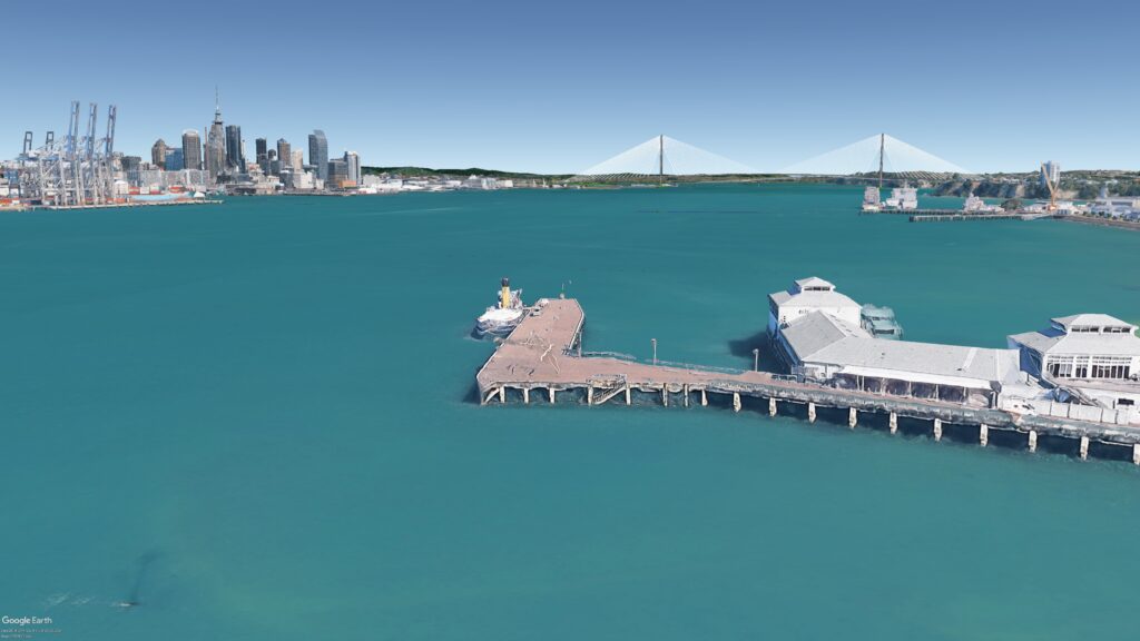
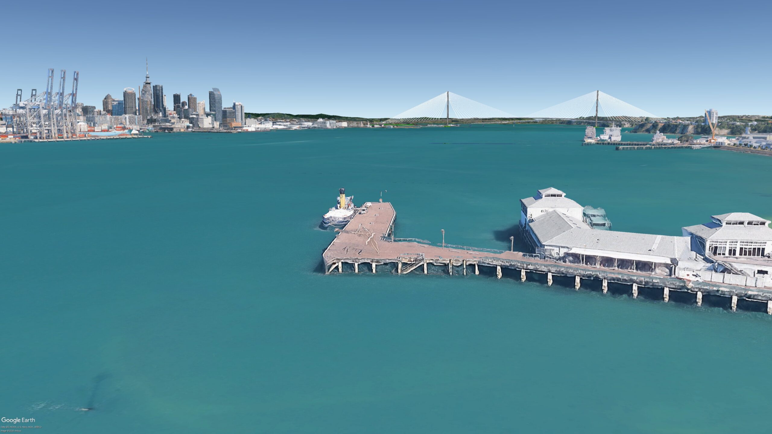
A view of the Waitematā Bridge and city skyline from Devonport. Image: Nicolas Reid/ MRCagney
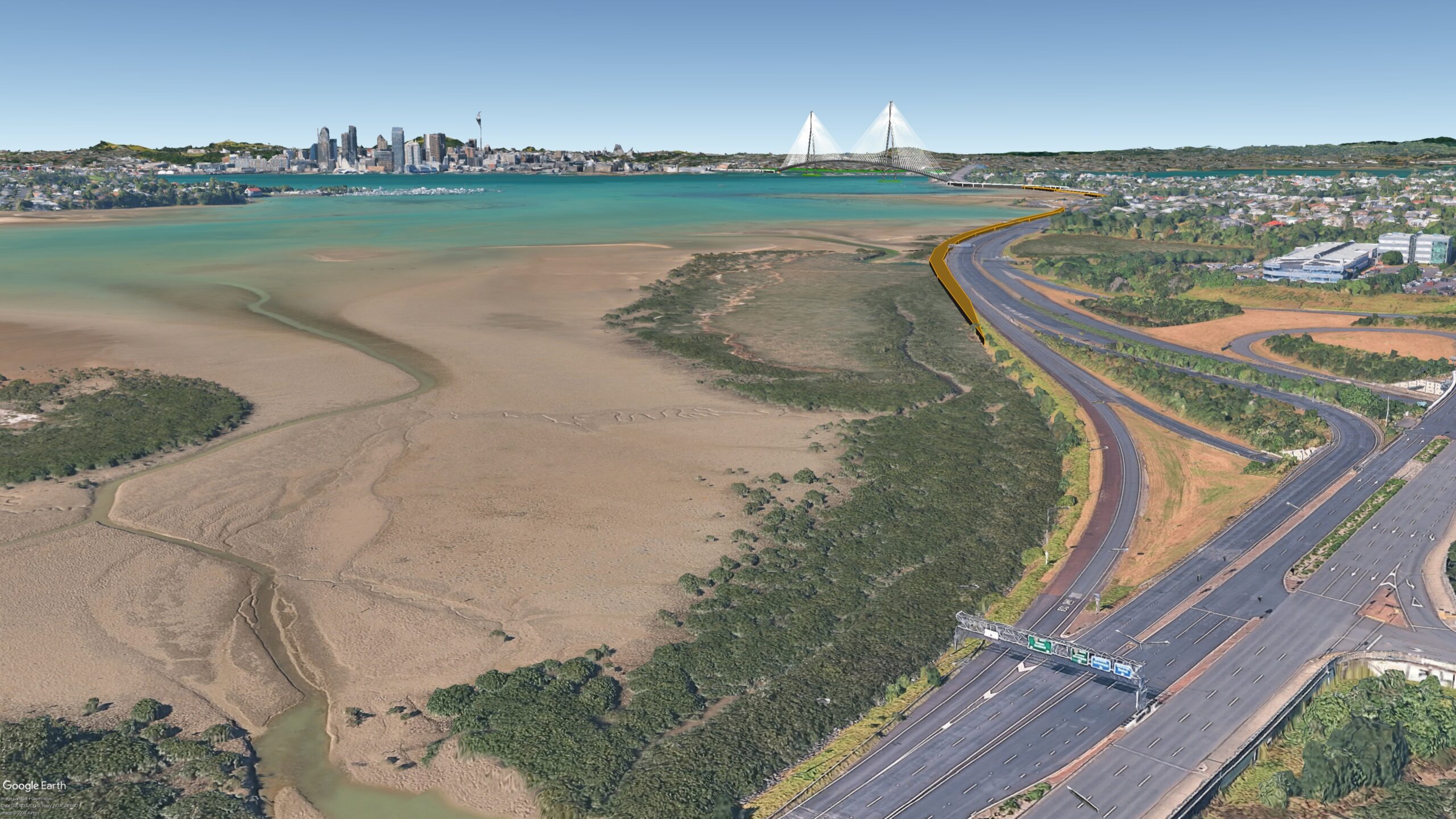
- In the north, it would start from the middle of the motorway at the old toll plaza after the Onewa interchange, bridging straight across the harbour and Westhaven marina to join the Victoria Park viaduct and the Central Motorway Junction just above the Fanshawe Street off-ramps. This alignment directly links the two points where the current transport networks have extra capacity, on the shortest and most direct path.
- A new two-lane extension of the busway would be built on a seaward side embankment from Akoranga to Onewa and the start of the bridge, with a shared path alongside. This would allow the full width of the existing carriageway to be used for ten motorway lanes between Akoranga and the bridges without further widening, and the raised embankment would protect the motorway from storm surge flooding.
- A second on-ramp would be added to Onewa Road for drivers heading south on the motorway, while the existing southbound on-ramp would remain for accessing the city over the existing bridge.
- There would be no works further south than the tie-in to the existing Victoria Park Viaduct and Fanshawe Street. This avoids the need for major tunnelling works and disruption through Wynyard Quarter, Victoria Park and the Central Motorway Junction. North of the bridge landing, all the additional works would be alongside the existing motorway, enabling them to be delivered with lesser impacts.
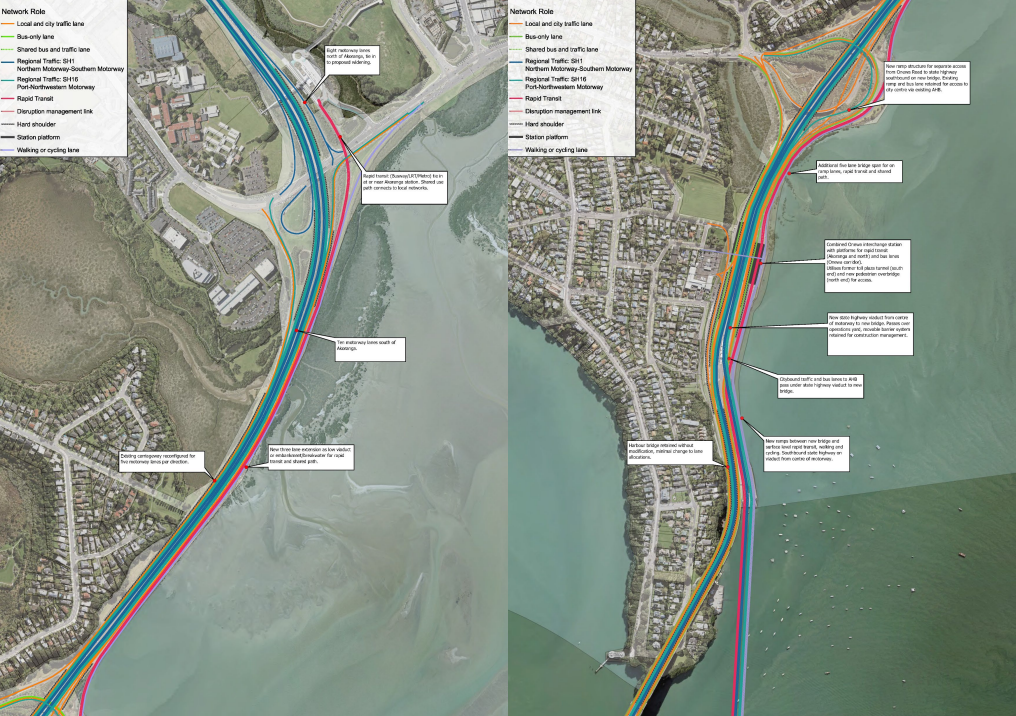
The motorway and public transport connections on the North Shore. Motorway lanes in blue, city access lanes in orange, bus lanes in green. New embankment with rapid transit and active modes in red. Nicolas Reid/ MRCagney
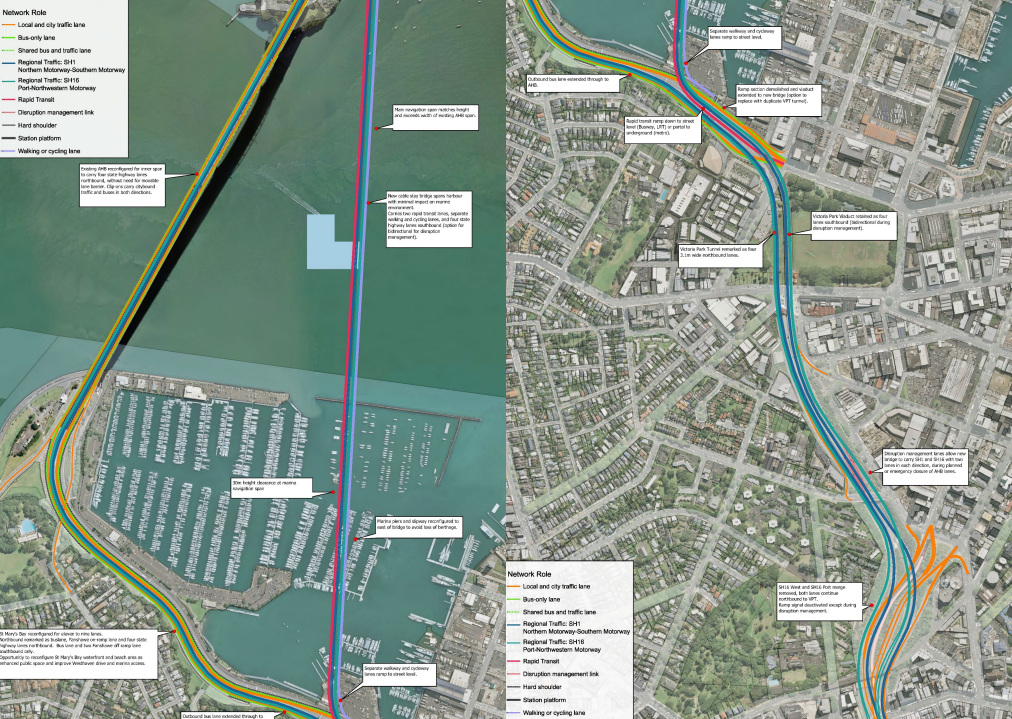
The Waitematā Bridge and Auckland Harbour Bridge, and connections to existing network at Fanshawe Street and the Victoria Park Viaduct and Tunnel. Nicolas Reid/ MRCagney
Rapid transit, buses and active modes
The new bridge carries a dedicated rapid transit lane in each direction, and walking and cycling paths either side ramping down to Fanshawe Street and the waterfront paths. Bus lanes would run on the outer two lanes of the existing bridge (with traffic exiting to Shelley Beach Road being able to use them as far as the off-ramp), continuing through St Marys Bay as bus-only lanes.
- The rapid transit lanes on the new bridge would initially be an extension of the two-way busway from Akoranga across to the city centre. The geometry of those fully separated lanes would allow them to carry light rail or metro in a future stage, either to the surface in the Fanshawe Street median, or to a viaduct or tunnel extension.
- Buses from the Onewa Road corridor would access the city centre via bus lanes on the existing harbour bridge, much as they do today – while most buses from north of Onewa would use the parallel rapid transit crossing on the new bridge. This separate-corridor design allows bus and rapid transit lanes to be provided but avoids the need for multiple bus access ramps or busway interchanges across the two bridges, although buses from either corridor can still access either bridge using the motorway lanes as needed.
- An Onewa interchange station would allow for interchange between these two corridors, and for local access to Northcote Point. It would have platforms either side of the motorway for the bus lanes, and a busway platform on the seaward side for rapid transit.
Lane balancing and traffic operations
As noted above, the combination of the new and existing bridge would provide ten traffic lanes across the harbour, which balances with the number of lanes that already exist either side. The main improvement for traffic, other than separating commuter and through-traffic, is that it adds the missing counter-peak traffic capacity that is currently removed from the motorway with the variable barrier system.
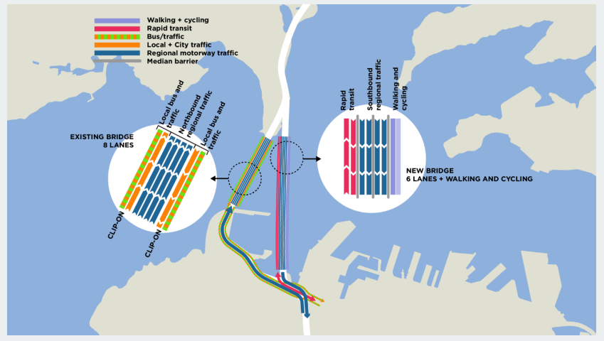
The network plan for state highway lanes, city traffic, buses and rapid transit across the existing and new harbour bridges. Nicolas Reid/ MRCagney
- The new bridge would have four motorway lanes carrying SH1 southbound to the Victoria Park Viaduct, plus rapid transit, walking and cycling.
- The existing bridge would have four motorway lanes in the centre span carrying SH1 northbound from the Victoria Park tunnel, while the four clip-on lanes would support a local traffic lane and a bus lane in each direction to and from Fanshawe Street and the Pt Erin ramps.
- The movable barrier system would be removed from the Auckland Harbour Bridge, as the two bridges would allow the full peak capacity of five traffic lanes in both directions at the same time. The four lanes of the central span of the existing bridge would all be in the northbound direction, which means they would not need a median barrier. This avoids the awkward single counterflow lane that happens currently, and means the lanes could be wider or have additional separation from the bridge structure.
- For regular operations, the new bridge would match the current Victoria Park viaduct, with one set of two lanes leading to the southern motorway, and the other set of two lanes leading to the Northwestern motorway (SH16), Ports of Auckland, and the Wellesley Street and Cook Street off-ramps. However, the four new bridge lanes could be operate as two lanes in each direction. This allows for resilience for planned closures: in the first instance, the central span and the clip-ons of the existing bridge could be closed in stages for extended renewals and refurbishment, while keeping eight lanes across the harbour as they are today.
Capacity
The dedicated rapid transit lanes, in conjunction with bus lanes and active modes, add a huge amount of capacity across the harbour. Add in the missing counter-peak highway lanes and city access lanes, and the pair of bridges mean an adaptable and robust multi-modal transport spine with massive benefits and resilience.
- The current bridge has capacity for 6,000 (counter-peak) to 9,000 (peak direction) private vehicles per hour each way, plus 7,500 bus passengers per direction.
- The combined bridges would have capacity for 8,000 private vehicles per hour both ways on motorway, and another 3,000 vehicles both ways to and from city centre, plus 7,500 regular bus passengers and another 9,000 passengers per hour each way on rapid transit, plus capacity for up to 5,000 cyclists and 5,000 walkers each way per hour.
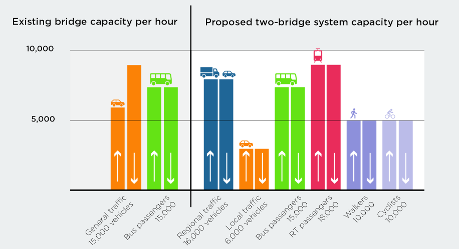
Capacity per hour of the current bridge, and the proposed two-bridge system. Image: Nicolas Reid/ MRCagney. (So, 30,000 humans in cars and buses, vs 75,000 humans any way they like)
Other impacts and benefits
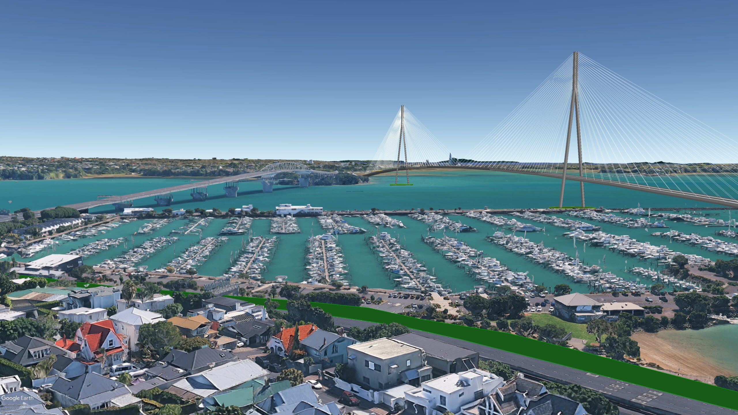
- The adjustment of lanes across the old and new bridges would free up three redundant lanes in Saint Marys Bay, unlike some other proposals that would require further widening of the corridor through Saint Marys Bay and into the Marina. This would allow the return of a 15m wide strip of waterfront land to be used for improvements to the beach, public space and Westhaven Drive.
- The bridge would pass over Westhaven Marina, requiring a minor reconfiguration of the berths directly below but allowing 30m clearance over the access channel. The Wynyard Quarter marine industry precinct, superyacht marina and part of Westhaven would remain on the seaward side of both bridges.
- There is the potential to run four lanes northbound through the Victoria Park Tunnel to match the four northbound motorway lanes on the bridge, either by remarking narrower lanes or expanding into the existing width of the main tunnel box with a new emergency escape tunnel (more on that idea to come).
And what about the cost?
To talk about any proposal without a look at the cost is just an exercise in daydreaming. So, to tally up the bill, this proposal is for:
- a 2,000m long six lane cable-stayed bridge,
- 800m of approach viaducts,
- 1,500m motorway widening for an embankment carrying a busway extension,
- an additional on ramp at Onewa, and
- a bus-rapid transit interchange station at Onewa Road.
Comparing to similar bridge projects abroad, the bridge itself should be a $2 to $3 billion proposition. A second harbour bridge is still a huge project, but crossing the Waitematā with a multimodal bridge needs nothing particularly remarkable in terms of bridge design or construction methods.
The connections, embankment and support works should cost no more than half as much again, if we look to things like the SH16 causeway raising project, the Northern Busway extension to Albany, and the motorway works along the Onehunga foreshore. Again, there’s nothing remarkable about the connections either side, and there’s nothing in it that we haven’t already done in Auckland.
This being New Zealand in the late 2020s however, things are more expensive, so we can inflate those figures a bit. But altogether the package should cost less than $6 billion. That seems low compared to many recent project proposals, but it’s important to compare the actual extent and scale of what is, and is not, proposed here.
Most importantly, this proposal avoids a lot of high-cost elements that are part of other harbour crossing suggestions. It is largely an offline construction with minimised impact on the existing motorway or busway. It doesn’t require modifying the Central Motorway Junction, nor does it require major new motorway interchanges built north or south of the harbour. It doesn’t require tunnelling motorways halfway up the north shore, nor extensive new ramps or elevated structures instead.
This proposal aims at getting the best bang for buck by only adding the missing elements, and designing to meet the existing network connections and lane capacity. Designing for a smaller scale project that delivers the main outcomes should lead to a crossing that delivers huge transport benefits, while being affordable enough to actually fund and progress on a realistic timeframe.
So, what do people think? Let me know in the comments!
–Nicolas Reid
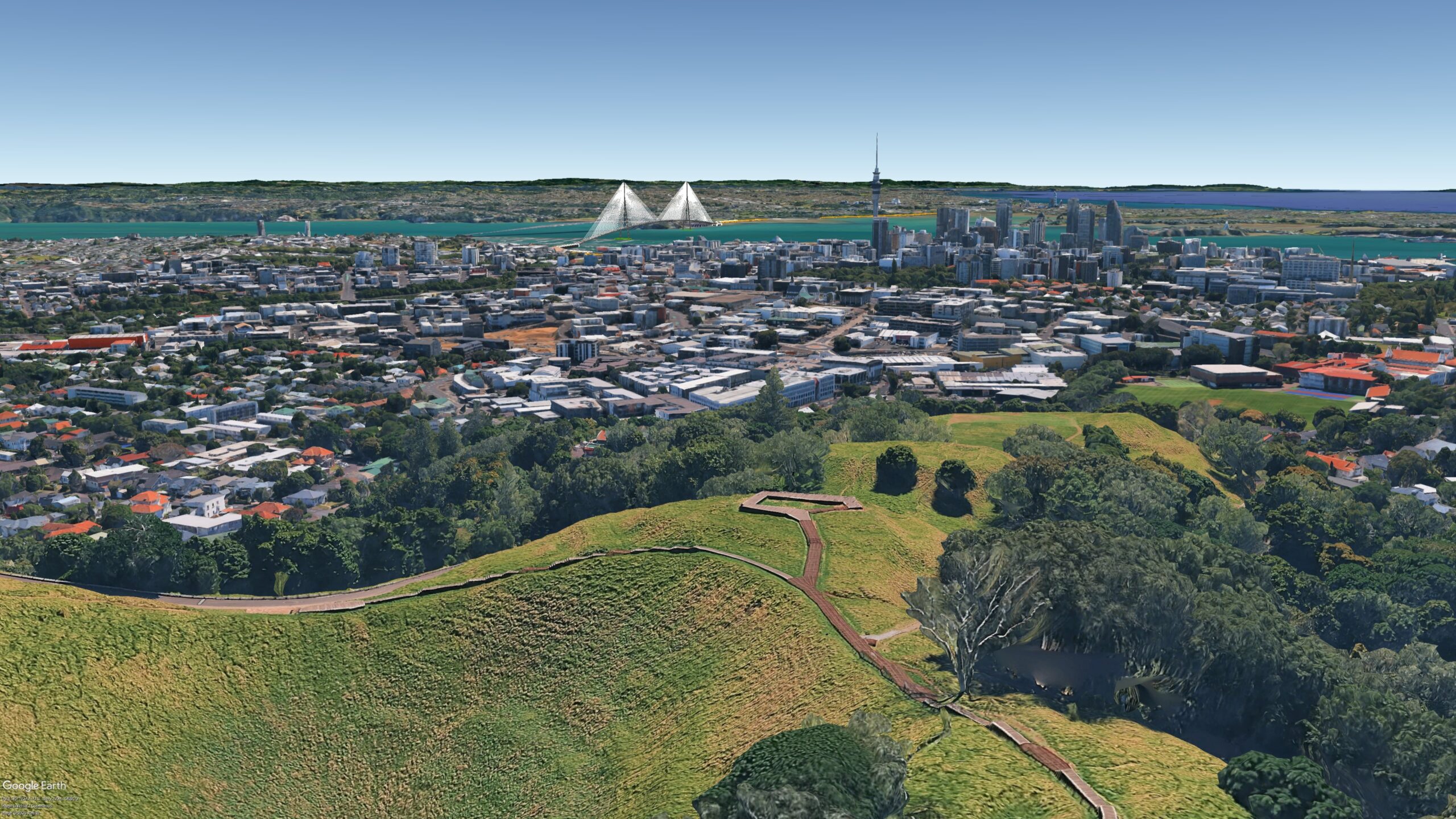
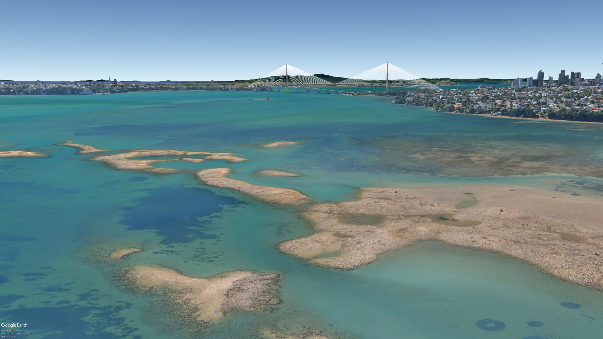
Note: You can click on the images below to see larger versions. For further details of the proposals, see: Waitemata Harbour Crossing Bridge proposal MRCagney (11-10-2024) v3
We like it! And we’ll have more to say in coming weeks. If you’re keen to support Greater Auckland’s work pushing for a brilliant, beautiful bridge as the heart of a top notch 30-year transport plan for our city, you can donate here. And as always, please feel free to share our work widely. This conversation belongs to ALL Aucklanders, and we all deserve to be part of it!

 Processing...
This post strikes me as a helpful reminder that a little bit of knowledge can be a dangerous thing. Construction of a bridge is incredibly complex (particularly in a live motorway network), will require large amounts of reclamation, have enormous amenity impacts as well as visual pollution, and is based on some very ambitious cost assumptions. In addition, having a hulking great bridge land at Westhaven overlooks the legal and visual challenges of that issue. A bridge structure has also been routinely rejected by mana whenua. The tunnel delivers benefits that the bridge structure never can which have been looked at during various stages of the business case phase.
Tunnel proposal costs at least $6b more than this proposal. That’s a hell of a lot to spend just because you don’t like the look of a bridge.
This costing isn’t particularly accurate and at best a mildly well informed estimate. Glossing over the complexities of constructing a hulking great bridge structure on the waterfront and a live motorway doesn’t mean we should jump into building one either. Personally I don’t like the idea of having a huge bridge landing anywhere near the waterfront after Aucklanders have been saying for decades they want the waterfront returned to better public use.
Erm, Aucklanders have been asking for a bridge for people who want to walk and cycle across the Harbour since the Harbour bridge. Nobody has asked for a road tunnel except the consultants who are absolutely creaming it in detailed investigation fees for a project that will never get built because it would bankrupt us, in essence another Light Rail debacle. You’re not one of those consultants are you?
“Aucklanders have been saying for decades they want the waterfront returned to better public use.”
That’s a reason to support this option. This project would allow us to double the width of Westhaven Drive so people can access the waterfront. This option also provides access to the entire waterfront from Esmonde Road to the bridge.
The idea that because a bridge is big and complex,
we should spend three times as much on a tunnel that is three times as big and complex so we can pretend that there aren’t any impacts… did you work for ALR perchance?
My thoughts exactly.
The new bridge will be the pride of the city greater than the Skytower. This idea that any construction is “hulk / visual pollution” is a strange new idea. People love big cool civil infrastructure especially if they can walk on it and feel connected.
The age of “cost is no object” projects if we avoid annoying 2 birds and a dozen angry rich layers is over. We cannot continue to box ourselves in if we are to have the infrastructure we need to succeed.
Best thing they could do is design this bridge to completely block the view of the old dunger alongside it. If you want to talk about visual pollution, lets talk about the shit we already got first.
Tear the old one down and build a fit for purpose bridge in it’s place. One bridge is enough if done properly.
The current bridge is nothing special nor is the design above.
Ensure rail, bus, walking and cycling have precidence over private motor vehicles.
Put a toll on it and watch everyone more to rail and bus from the Shore.
While I agree on the aesthetics of the current bridge, I kind of think we should replicate it on the same alignment. I’m a sucker for symmetry.
are we coming full circle back to Tamahere/McKenzie’s proposal to build a new bridge superstructure and just shunt it across onto the existing piers?
“are we coming full circle back to Tamahere/McKenzie’s proposal to build a new bridge superstructure and just shunt it across onto the existing piers?”
That proposal was completely unworkable. A better option for the 2nd harbour crossing is the design that has been proposed by Reset Architects; See: https://reset.co.nz/news/fresh-thinking-needed-on-second-auckland-harbour-crossing
Who has pride in the sky tower? It has been a blight on Auckland since it was built. jaboas just another bucket on a stick. I am ok with a new bridge but tear the old one down.
build a bridge…get over it. Simple really
I suggest wait until the rail linkis at least upand running, barein mind, this will be another debt rate payers of the region will pay for….
I don’t hate this proposal
Why is it being built? I thought we need a new bridge because the old one can’t handle heavy vehicles. But this seems like its about capacity, with heavy vehicles still using the existing bridge. In which case Brown is right, why add more road capacity in the same place, which means more traffic heading into the city even if they don’t want to head into the city.
The current AHB main truss bridge is fine with long term maintenance. The clip ons (2 lanes either side) need to be removed as they are structurally unsound long term.
We also need a new connection to better optimise traffic movement, enable PT and Active modes.
A new connection will enable removal of the clip ons much more easily. It’s a range of factors.
Could we just replace the clip ons with new clip ons? Obviously disruptive but considering its been 60 years since they were put on technology & engineering should have improved somewhat?
Replacing the clip ons with new clip ons means taking them out of action for a year or more, so you really need a new crossing first.
My preferred option would include a heavy rail crossing to which could also carry freight, but to be fair I am not sure what a good heavy rail solution would look like
Maybe a line from next to Parnell Baths that links up with SH1 near Takapuna
A HR option could also be the start of a direct line up to Whangarei. But I doubt HR will ever be the rail option across the harbour.
Unsurprising that heavy rail isn’t even a part of the discussion as Kiwirail weren’t included in the early stages of the business case, I’m not mad just disappointed
Thinking more about a potential tunnel from Point Resolution to Devonport, this seems to make a lot of sense especially for freight haulage to Northland as the junction would be right next to POAL
Then you have issue with going through Devonport?
Longer term I think a HR tunnel diving under the Waitemata at the point where it curves at Point Resolution/Parnell Pools all the way almost directly straight to the motorway at Akoranga, then for cost saving run it probably elevated in the centre of the motorway at the appropriate point. May have to squeeze the lanes up or shift them all a best west to fit the pillars but modern ones can be pretty slim? Actually thinking about it you have the interchanges/bridges in the way so better to run it on the left/west at surface level from the Akoranga walk overbridge point say. Probably a lot more room and bound to be cheaper at surface level. At interchanges trench the rail (on/off ramps could be raised slightly too?).
Forget freight. There is so little anyway, but also better to develop NorthPort, with Marsden Link rail connection, instead of trying to drag stuff down to Auckland the rough a passenger system.
Devonport has a rapid Ferry (new lecky ones actually), is not growing (actually shrinking). Will not be on any RT line to the Shore.
Read the problem case! Devpo is not it.
Forget freight? Forget heavy trucks over the bridge
Also trucks travelling POAL to North Shore and vice versa currently block up the CBD and spaghetti junction, potential decongestion benefits could be significant
“instead of trying to drag stuff down to Auckland the rough a passenger system” – what are roads?
If not doing freight, that’s right they have provision beside Te Waihorotiu for underground connection to an alternative system. So yes, automated metro is the way to go. Shorter tunnel too.
There’s freight, and then there’s delivery.
Rail can’t do the later, always gonna be by road. And that’s what the light industry and commercial centres on the Shore need.
Rail does heavy bulk services well, especially over reasonably long distances. Then it really shines.
Absent a more balanced regulatory regime (ie charging road haulage properly for the damage it causes and the pollution it generates), this will not change. And that is unlikely, all change has been heading in the other direction for decades.
Interestingly I recall the analysis that says build Marsden rail link and the rail freight task from Northland to Auckland actually declines, because the best rail freight work in Northland (milk-powder and logs) will instead head up to NorthPort.
This is good, is what Port of Tauranga did too, grew bulk export trade from its hinterland there by rail. Great for resilience, Upper North Island should build to a three port strategy. And we already have the NAL for any development of AKL-Northland rail task, which is currently small.
The rail case for the North Shore is passenger. Urban passenger.
I have yet to see a good case for passenger rail to the North Shore
To replace the busway eventually when it can’t cope as per forecasts. They can do improvements to cope for so long then pretty much need rail.
In my eyes a heavy rail crossing kills 2 birds with one stone, and lots of future development opportunity in connecting the line to the existing network further North
I am using the term rail very loosely, including Light Rail, Light Metro, Metro or whatever, the case for rapid transit to and through the Shore is made by the success of the current partial RT of the NX1 and NX2.
What form that best takes is up for debate. I am certain that isn’t any kind of extension of our current Cape Gauge system, however. For cost, constructibility, and effectiveness reasons.
For lols, this is what previous me thought could work 14 years ago. Essentially this is based on the untested assumption that the only way forward is by extending the current system. I was also somewhat obsessed with reducing reliance on the Vector curve, and conflict at the Britomart throat.
I do not think this is the way forward, there is far greater advantages in adding a new separate system to the mix in Auckland to complete the network.
https://www.greaterauckland.org.nz/2012/04/20/the-cross-future-pattern-for-auckland-rail/
Point Resolution to Devonport has another advantage, which is that there are basically no existing structures in the way and a good amount of runway to lower/raise the track grade in the lead up to a crossing meaning disruption would be minimal, same with land purchases required
And it would also benefit over 20 people! Honestly, do you plan for massive intensification in Devonport? I think there are way better places on the shore that should be prioritised or already are, such as Northcote and Takapuna.
Dunno just spitballing ideas, guess we’ll have to wait and see what NZTA have come up with
Where are you carrying the freight too? Wairau Rd? A fully automated rail like Sydney has built would be the best from Orewa thru Albany, Glendale, Birkenhead, Auckland Grafton, epsom, royal oak, airport. I could get in board with that. Of course I live in Silverdale
This looks much too sensible to be built in New Zealand.
+1
Yes, defiantly too sensible i was going to say same thing. Which is why it will never happen they will go for some overly expensive tunnel which will get bogged down in difficulties and will end up being too small and they’re going to have to build another bridge in twenty years’ time.
Yes, definitely too sensible . . .
So this is just inducing more car traffic? 15,000 – 22,000 cars?
What happens to all of these cars in the surrounding roads, etc
“What happens to all of these cars ?”
12 lanes north, 12 lanes south – that’s plenty of parking space.
This was my reaction. Good idea for a second crossing, but fundamentally just a great way to encourage more sprawl and more driving?
Is literally the only reason NZTA is going for a gold plated tunnel because they don’t want to have the fight with NIMBYs about the aesthetics of a bridge?
Basically yes. And they don’t want to pick a fight with lawyers of St Mary’s Bay. And (I suspect) the engineers are annoyed that CRL was a bigger project than Waterview and they want to do something even biggerer.
Isn’t this what the fast track legislation is specifically designed to address? Small groups of NIMBY’s hamstringing major infrastructure with their personal interests. If the fast track can’t be used for this then it’s pretty useless. This could well achieve cross-party support.
Just get an enabling act like the LNG terminal. Rule out any legal comeback.
The government can just do things if it wants.
This looks so much more sensible than the tunnel.
The business cases have all assumed very early on that the planning challenges make a bridge infeasible. However,they have completely ignored that the tunnel
A) Has massive planning risks itself, most notably reclamation for the monster interchanges
B) requires significantly more property purchase
C) is likely to cost 3x more than a bridge. That additional budget could be used to offset effects.
The business cases have also said that mana whenua support a tunnel, they have never indicated whether mana whenua support a tunnel, even if it costs 3 times more.
Indeed. Mana whenua have a much more nuanced position than this, with their main aim being to improve the overall health of the Waitematā Harbour. I suspect they’re annoyed at being used by NZTA as the reason it’s supposedly necessary to spend billions of dollars extra of public money.
I find the official team’s long running foregrounding of “consentability” as key reason for rush straight to tunnels unconvincing, as like the first harbour crossing this one is bound to come with an act of parliament.
Planning niceties likely to be irrelevant.
Given the current coalition’s rush to move all major decisions across multiple workstreams away from independent bodies direct to ‘at the Minister’s discretion’ combined with an open willingness to accept bribes (opps, I mean Party funding contributions) and clamping down on Judicial adventurism I have to agree with Patrick that you, me and the St Mary’s Bay lawyers are not going to get much of a say.
I don’t like it when car-centric infrastructure proposals are sugarcoated with a transit line or two. If you really want to spend a ton of money on that crossing, build a proper metro tunnel under the harbor.
Yea this is still a massive new motorway being proposed in [current year], with the rail component effectively non-existant.
Considering the north shore has basically no rail network anyway, not sure that this is a fair criticism. Building a road bridge makes sense because the rapid transport on the shore is the bus network. A road bridge also allows for easy conversion to light rail and active modes in the future. It also addresses the fundamental problem of the original harbour bridge having future structural concerns.
Nothing has been built, this is a planning exercise. Ideally when you plan, you plan for the future not for the past
All the noise from Wellington indicates the new crossing won’t cater for buses, at least not dedicated lanes for rapid transit. That will eventually come via an allocation of lanes on the current bridge, but only once the new one is up and running. So 2035, at the earliest.
Even if it came in at 8 billion it is a way better investment than the holiday hiway to whangarei .The only problem I see is that it is way to simple for the naysayers to get their heads around .During the build the existing traffic flow would be maintained as most of the build would be done from the sea on barges .The minimal road works at each end are a bonus and would take but a short time to complete .
No doubt the government will not like it because Willis will deem it to expensive because it might cost over her default figure of 3 billion ala the ferries and other projects she has scraped .
Another brilliant grand project to get more cars across the harbour, when all that is needed, are just more ways of getting more people across the harbour.
A super grand trophy project promoted by our vested interests to turn our taxpayers money into their profits and at huge cost to our environment.
When all is required, is just some more modest projects like the now two decades old busway, to just deliver a growing population’s need for more people moving capaciy across our harbour.
Achievable, by just using far more spacially, and therefore economically, efficient transport options
Our consultants and politicians need to cast their gaze away from US extreme private transport bias, towards the more sustainable European balance, of enhancing Public Transport and micromobility options..
Since the rapid bus successes, car trips are declining, now >50% of people crossing are NOT in cars. This proposal seems to have missed the memo, going from 15,000 general traffic vehicles per hour (their numbers) to 22,000 vph despite adding 38,000 vph via RT, walking and cycling.
Im not disagreeing with the bridge/proposal – it does seem like the big spend (12 lanes) is cars despite congestion, fuel shortages, parking and high expenses of that mode. Is that what we want in 2035?
Like it or not, at least 4 lanes of general traffic lanes need to be built within the next 20 years before the existing clip on lanes fail (and they’ve done all they can pretty much to upgrade them already).
I fully support RT (especially love rail) but that doesn’t negate the above so I see this proposal as a good option.
My concern is that it would need to be designed to be protected to allow use in high winds.
The major new feature is the addition of “rapid transport” – I presume this is LRT – so a LRT network has to be added in other parts of the city as an essential element of the project (the tram won’t just go from Onewa to Halsey Street, right?)
Knowing NZTA it will be for buses, but they will pinky promise to build tramlines later
A great advantage that direct and dedicated Rapid Transit lanes on a new structurally sound bridge across the harbour offer, is that it makes starting on a through routed LR line much more possible.
The cost will be on the system alone and not also a crossing. And it means being able to begin with a Shore anchored first stage. For example Takapuna to Town Hall, with an initial depot at Akoranga.
To me this looks like an ideal initial operating section, with immediate strong demand, good integration with the wider network, at both ends. It is important to address strongest demand sections first.
Build the bridge RT lanes with rail embedded at the start, quite common for buses and LRT to share RoWs overseas. Fine to do that initially.
Later stages to Mt Roskill, Mangere and Albany to follow.
It will boom exactly like Sydney L2 + L3, done properly.
Staging is important.
One of the failures of ALR was it’s LARGE scope.
Sydney staged it’s very successful LR projects.
Possible, but not guaranteed
Anon,
a PT/active modes only option is not going to happen even if it would make sense. Politically it’s dead in the water. This delivers the Active Mode connections and addresses the supposed other outcomes a road tunnel is supposed to achieve i.e. resilience and capacity, leverages what we already have, doesn’t stuff the city centre and doesn’t bankrupt us. It’s the most pragmatic solution I have seen so far.
Not with that attitude it’s not going to happen, and for the record I also think road tunnels is a stupid idea. They would need a stupidly large bore size tunnels to fit 3 lanes of traffic through the tunnels like NZTA seems to be wanting
Umm, couldn’t find trains in the post
1train, 1 driver 8 to 10 carriages is better than 10 buses
The bridge we want exists already
Think it’s from Norway to Sweden
The pylons are like a Y
In the centre of the Y are double train tracks on top of the Y as a platform is a 8 or 12 lane highway
To see it in action is a tv series whereby a murder takes place with the body cut in two 1 half is on one side and the other half is on the other side of the border that is in the middle of the bridge thus 2 country’s police must solved dubbed
When I saw the bridge thought immediately of Akl said this is the bridge we want will try to find the name
That bridge could run a side lane to narteranga bay as will as Onewa
While the urbanist in me says build a public-transit-plus-walkable-modes bridge and be done with it, the political reality is that attaching four highway lanes to it is probably the most expedient way to get the thing built by our centerist, risk-averse major parties.
I like this proposal for two major reasons:
* It’s a bridge rather than a tunnel, and therefore likely to be magnitudes cheaper. The major reason for preferring a tunnel seems to be to not offend anyone, which is how we end up with proposed projects like $15b “tunneled light rail”.
* It minimizes the changes to the road network at either end of the bridge which made a substantial contribution to the costs of earlier proposals.
If the latest study comes back recommending some super-expensive boondoggle (like tunneled light rail…) it will be interesting if any political parties pick up this proposal to champion at the election.
If you want to kill a proposal, go underground.
Aucklands Surface LRT would be up and running by now.
Rocking Dominion road, and delivering locals to the Airport but Drill baby Drill (and Winstons handbrake) turned promised delivery into a pile of mouldy reports.
1920s NZ: Let’s build a tunnel through the Southern Alps
2026 NZ: Tunnel complicated and too hard 🙁
There’s a huge difference between building a single track rail tunnel in the mountains in the 1920s and a six lane motorway tunnel under central Auckland and the harbour in the 2020s
I was being a bit facetious, the Ōtira tunnel was far from a simple job. Interesting tunnel though, with it originally being electrified but only the isolated tunnel section, meaning it had to have its own electric locomotives, and now the diesel engines that run on that line need specially modified air intakes to cope with the poor ventilation
I think the first question to be asked is whether the high clearance needs to be maintained to the upper harbour?Does the navy really need to have its ammunition store up there, ( has anyone seen a boat actually access the stores, it would seem much easier to just load the ammo into a truck and take it to Devonport to me).And the sugar refinery , I’m sure they could just as easily use barges if they want to stay in what is essentially a residential area.
Yes, the Navy do sail their ships up the harbour to that depot. Though with a clearance of 43m, I believe the current bridge is far higher than it needs to be to cater for our decidedly mid-sized naval vessels. If any Seamen among us happen to know the air draft of HMNZS Canterbury, please chime in.
Trucking a bunch of high explosives through Devonport may not be the smartest move, though I would be interested to know how the ammo gets to/from that warehouse in the first place if not solely by ship.
Same with the Chelsea works, I’m sure there are plenty of small bulk carriers around which are able to haul adequate amounts of sugar without needing to be 43m tall.
Thanks Nic and all who’ve put this together.
Aucklands hanging together via a thin spindly 67y old bridge. The clock is ticking, and trucks are a thumping.
Bridge v Tunnel? Daytime streetlights in a concrete hole or views of the Waitemata, its a no brainer, except to the Wellington accountants, who cant see the tourism gold.
Location/Style of the bridge and cost – Just Do It ! Gerry Brownlee’s cancelling of the Western Busway has cost Auckland $4B+ (old money not this weak new NZD) in congestion, 99M liters of imported fuel and subsequent emissions and additional car running costs. Not doing transport infrastructure costs us more than doing it.
The proposal is very road building government friendly with delicious massive increases in car/truck VKT. The 20,000 pedestrian and bike per hour shown in the render looks to be carnage – i cant snip in a pic, but hunt it out on the MCR link. Gramps+kid vs cyclist v eBike/eScooter and whatever Timu can deliver to the teenagers in 2035 very much is not part of this solution. If delivered – expect a future 50years of why didnt they provision for micromobility? conversations, did they not learn from the previous 50y…
Do Better – our GPS should not limit our vision.
Building the bridge 30m to clear the yachts of westhaven, that suggests more massive public cost generated to spare the berth holders of westhaven. Time to find a better location for the pleasure craft?
Thanks team again – but the problem is not bridge/tunnel or Active Transport (in a tunnel?) vs cars. Its governance and Auckland/NZ’s ability to deliver. I like the Mayors question – what are we solving, even if his choice of Neighbourhood to destroy suggests it lacks seriousness.
Im very much looking forward to riding across our harbour and even this bridge. Until we can get past the politics and inertia, it has to be Sydneys stunning harbour and bridge and their new active transport infrastructure delivery, or even Petone !
My money is on GA writing which solution articles in 2036, and how to cope with the staged lane shutdowns as new steel is welded into the now 77year old Auckland Harbour Bridge.
Are there many other cities that have 2 bridges connecting to exactly the same point. You start to see how both contrained Auckland is and how ridiculous our road system is. We already have 2 bridges and 2 different ways to cross the harbour.
I’m still confused as to what problem is trying to be solved? Because for all this effort it has to solve a huge problem..we haven’t even tried time of use charging either.
Either a PT and cycling bridge built cheaply, low down because we don’t really need to make a bridge expensive just so Chelsea Sugar factory can get through…or knock down the old bridge and build a modern, 8 lane plus underslung PT and cycling bridge.
“I’m still confused as to what problem is trying to be solved?”
So am I. If the problem is that the current bridge can’t handle the weight of trucks and buses, build a special bridge for them (with walking and cycling too). This would be even cheaper, allow buses to have their own lanes, and allow the other bridge to last much longer.
If the problem is that the current bridge gets a bit busy, that is not worth spending billions on.
err… https://www.greaterauckland.org.nz/2026/05/26/give-aucklanders-a-real-say-on-our-next-harbour-crossing/
Are you referring to “After which it will be able to carry heavier loads more securely, and indefinitely”? There seems to be a different opinion depending on where you read it.
If the bridge is fine indefinitely, surely the obvious thing we need is a walking / cycling / PT bridge. More car lanes won’t fix anything!
I am with you Jimbo. What is going to happen to traffic demand when road tolling starts? What will mode share look like as NZ becomes poorer as it will in the next decade, hit by rapidly rising health costs; likewise with superannuation (thanks Winnie for taking us more quickly to that point) and climate change clean-up (21 state of emergencies so far this year.
Auckland has barely begun to tap what can be achieved using public transport to move people. e.g. each day tens of thousands of people travel between Takapuna and Devonport in cars, a bus leaves every 30 minutes.
Currently: one mouth, one throat, one stomach.
$3b later: one mouth, two throats, one stomach.
“Are there many other cities that have 2 bridges connecting to exactly the same point.”
NYC with the Brooklyn and Manhattan Bridges. New Orleans with the Crescent City Connection Bridges. Montreal with the Quebec and Pierre Laporte Bridges. Tacoma with the Tacoma Narrows Bridges.
“Are there many other cities that have 2 bridges connecting to exactly the same point”
Yes, twin bridges are exceptionally common. You only need to go as far as Waterview, Panmure or Mangere to find them.
Or the upper harbour for that matter. In fact Mangere and Panmure are three bridge each. Seems like it’s a standard procedure more than the exception.
An imaginative, cost effective, attractive yet simple design that addresses the present common assumption that most of the future traffic crossing the harbour will be private vehicles and heavy traffic. What happens to the 4 traffic lanes when public transport once again becomes the norm rather than private cars? Can the design be tweaked to prioritize all forms of public transport (walking & cycling are public transport) and perhaps discourage car commutes??
One of the good things about this, is it can be adjusted. Ie it I reckon it should be manageable to say, reduce traffic lanes if you end up removing the Clip Ons on the existing Bridge, and/or convert to something else.
You can also address traffic inducement through other methods, ie Time of Use Charging, or prevent through-traffic to locations such as the City Centre to ensure only local access is enabled (ie what Access for Everyone does).
The first stage of the argument should not be bridge or tunnel, but simply what do we want it to do?
Presumably, to get more people across our harbour reliably when they want to go.
But from where? and to where, do these extra people actually want to go? Certainly not many from Northcote to Westhaven, so then where, and how else, is extra people moving capacity to be provided?
Where? Perhaps, also Meola or direct to Devonport?
How? The current mix of private car, to public transport, or pivot much more to the spacially vastly more efficient high capacity public transport modes? Thus requiring far smaller structures, and far less tarseal and emissions in our most valuable commercial land in the country.
Do we include the currently missing active modes?
Doing so really precludes any tunnelled solutions.
Instead as a recent topic highlights, here we are just being offered merely a product, a very expensive flash bridge to take more cars from Northcote to Westhaven.
https://www.greaterauckland.org.nz/2026/05/26/give-aucklanders-a-real-say-on-our-next-harbour-crossing/
The beauty of this design is with the separation of through traffic and local traffic could also be the separation of heavy and light vehicles. So, if in the future small electric self-driving PT units become available they, along with powered bikes could safely use these lanes. If these small vehicles were exempt from a congestion charge you can imagine a transformation of vehicle type and use in the lower North Shore and inner city. Smaller parking spaces would be an example of what we could expect.
My understanding is the bridge height only needs to be that high to allow for the occasional sugar delivery to the Chelsea Factory. Is there no other way this could be shifted to (for eg) the port and allow for a lower clearance?
It was built this high because there were optimistic predictions for a new port up by Te Atatu.
I dont think any of the fairly small ships used by Chelsea Sugar, and our own navy going to pick up ammo at Kauri Point, come close to the 40-odd metre clearance beneath the existing bridge. So I’m sure a new one could be significantly lower.
This is an excellent solution for the bridge issue. Will look closer on my PC soon. Forgot about Nicholas Reid as an option for this post, he being a planner.
I was expecting no general traffic lanes though I must admit.
Several people have noted that the view from the bridge will be worth it, whereas there is no view from a tunnel. I agree that that is also a huge selling point.
So, hopefully the politicians will run with this, assuming it isn’t too sensible for them.
For comparison, I costed Labour’s 2023 proposals for lengthy tunnels all over Auckland, and, after allowing for inflation, they came to the cost of the development of the Anglo-French Concorde, the cost of which was spread over 100 million British and French people at the time.
Now, to paraphrase the old Jim Beam ad, tunnels are nice but what we would have got for all that money ain’t Concorde.
Nor, of course, could we ever have paid for them in real life: Sir Humphrey Appleby stalling tactics to get the project killed after a change of government, perhaps?
CRL excepted of course. And maybe the Waterview tunnels. But you don’t want to build tunnels if you don’t HAVE to.
Squandering giving people an enhanced experience of the glorious Waitemata would be a crime, frankly.
Being out there above the Waitemata would priceless, frankly.
Beautiful is valuable, look at the response to Te Ara Tupua in Wellington, we can so top that here.
Do we need a full 6 lanes on the new bridge for general traffic? I realise you are matching the lane count to the approaches, but perhaps the approaches could go on a diet due to it’s current use is more for queuing space when the current bridge is not coping – and the steep climb slows traffic.
Theres a non zero chance that the existing bridges clip ons may need to be removed at some point. Plus I believe the lane make up can be adjusted anyways in the future
There’s 4 lanes for general traffic in Nick’s scheme
Oh yes, apologies, I don’t have my head around it properly yet obviously. Siri was reading the post out to me and I just heard six.
This is exactly what I would love to see, but I would have more towers supporting more spans, this will reduce the height of towers and enable heavier loads on any suspended deck at any time.
I like the idea of local traffic lanes, as I have lived on the shore for most of my life, and I have always felt like the North shore is a seperate city, isolated from the rest of Auckland, heading south to Auckland has always felt like a fuss, almost like you are heading away on holiday, even though it’s just a few hundred metres across the harbour.
Assuming we don’t have the guts to just improve the SH18 to SH1 connection, then this solution looks like it deserves a careful look.
Aestheticlly an enormous (semetrical) bridge over the harbour would enhance the Auckland panorama. The Auckland Harbour Bridge is a dowdy thing.
Michael Wood’s bridge alongside the current one is looking like a bargain.
Buses priority and future proofed for LRT. Walking, cycling, scooters and probably able to be used by trucks (to keep the road lobby happy).
All for under a billion and little, if any, visual impact on the harbour
Yes, and with two rapid transit lanes it would have been perfect.
I tried to get that at the time.
I really like it and thanks for showing practical sense as opposed to tunnel shear lunacy. Much better investment than the more Rons crew and Wk2tehana population 120 for $4.5B plus app = 10 to 12B.
And to y’all NIMBY naysayers…build a bridge and get over it. BUILD A BRIDGE!
For those on Bluesky, a user there has made some pretty lovely renders via AI for Nick’s scheme, admittedly with a couple of hallucinations:
https://bsky.app/profile/jonwiley.com/post/3mmsmnhump22w
i really like it – so much better than $20B+tunnels for cars only insanity. And much better value than the more Rons crowd with wk2tehana costing $4B+PPP costs of $6-8B i.e. 10B to $12B so we can get to te hana quicker (population 120).
Great effort and to the naysaying nimbys…build a bridge, get over it. Build a bridge, Build a bridge!
There doesn’t need to be two harbour bridges. This would look awful asthetically and would result in double the maintenance costs with retaining the current aging bridge, which needs replacing.
The current Auckland Harbour Bridge needs to be replaced with a new bridge, to a design similar to that proposed with the ANZAC Centenary Bridge a few years ago, which would incorporate road traffic lanes on the top, with rail, pedestrian and cycle paths underneath, running in a more direct route from the Victoria Park flyover in the CBD through to Northcote Point:
https://www.greaterauckland.org.nz/2009/12/04/anzac-centenary-bridge-information/
https://www.greaterauckland.org.nz/2009/12/03/the-anzac-bridge-idea/
Trams need to be reintroduced to Auckland in conjunction with congestion charging and a new harbour bridge. A new light rail tram line could run from Britomart to Takapuna via the new bridge, extended into a new central city loop running from the Wynyard Quarter to Britomart, up Queen St, along K Rd to Western Springs, and Ponsonby Rd, down College Hill back to the Wynyard Quarter. Light rail could also be added to the Northern Busway, linking to a line along Symonds St and Dominion Rd.
The new bridge and light rail could be funded with congestion charging on all motorways across Auckland, with removing all the congestion-causing on-ramp signals on the motorways and replace with toll gantries. There would still be free routes with using local arterial roads like Great South Road and Great North Road.
Land that the current motorway approaches to the existing bridge sits on, could also be sold to offset the cost of the new bridge.
I agree with you, except the bit about demolishing the current bridge cos its ugly. Just leave it, keep using it, and build the replacement bridge with all the kit along side.
Fantastic to see such an ambitious, yet affordable and deliverable, solution to our problems. It looks good. It minimises disruption while getting built, it’s easy to integrate, is flexible to our future changing needs. It provide active modes without requiring cyclists and walkers leaving the city to skirt all the way to Pt Erin (or somewhere else) to start their harbour crossing. I say Bravo! Well done. Let’s have a serious look at building it.
I like how the posters scheme separates regional and local traffic so we’ll.
a. I’d like to order 100 T-shirts with the new bridge on it thanks.
b. Can there be a variant with “Build the Bridge” so that spontaneous chants break out everywhere I go?
Thanks for all your work on this.
If there was a more detailed costing, the delta between it and the cost of a tunnel should ensure tunnel support is political suicide for any politician who claims to care about balanced budgets.
I am a Kiwi living in the Nordics and am quite impressed with the infrastructural competence and focus on sustainable transport projects over here.
This proposal reminds me of a cable-stayed bridge, Kruunuvuorensilta, that opened in Helsinki just a month or so ago. It’s dedicated solely to walking, cycling and trams; and it’s 1.2 km long, roughly equivalent to what’s proposed in this article. It also cost only 116 million euros (the bridge structure itself – the tram line and adjacent bridges cost much more – but still, amazingly inexpensive by Kiwi standards).
The geology and geographical context is somewhat different, as Waitemata Harbour is quite deep and the seabed is volcanic rock, whereas Kruunuvuorenselkä is not and has a granite seabed. Also, this bridge in Helsinki was built as part of a long series of bridges linking up downtown, the zoo, and a number of new waterfront neighbourhoods built on old harbourfront land. There was no major population centre on the other side like the North Shore.
Still I think this bridge in Helsinki is very inspiring, as it’s apparently the world’s longest bridge dedicated to PT and micromobility. Let’s make something similar for Auckland!
Not gonna lie this concept kind of looks like a copy paste job of that Kruunuvuorensilta bridge in Finland, not necessarily a bad thing
I sent a proposal to Mayor Wyane Brown and had a fairly good backwards and forwards debate with him. And Send Ministers.. something very similar even cheaper.. The clever part is the rail connection in CBD : please have a look also :
https://www.linkedin.com/pulse/new-auckland-waitemat%C4%81-harbour-crossing-under-1-fast-simple-anthony-rzyje/?trackingId=yU2AY%2Bb1RlaPNuSW3IWc5Q%3D%3D
I tried to comment on your linked post (but don’t think it worked): “Looks good. How would the light/heavy rail tracks get from Victoria Park to Parnell?”
The proposal is interesting and valid both technically and financially. The tunnel could have the ability to add a railway line but at a cost of double or more. A tunnel under the sea is also not pleasant. The bridges are beautiful. The fact is that a solution to a second crossing of the port of Waitemata is urgent and due to its cost and benefit this proposal seems impeccable to me.
This is a good looking concept but imo will never be built at this location unless perhaps, Wellington overrules Auckland and somehow legislates to avoid a mass of complex legal battles.
Auckland Council (who own and manage Westhaven Marina) have too much vested interest in protecting the existing marine infrastructure and their forward plans for development. When most old leases expire in September 26 (with the remainder of T pier eastwards in April 29) the lease model structure will change to a full rental fee mode. The annual income for Auckland Council? About $25-$30 million depending on occupancy. There are also plans to convert the Eastern pile moorings to cater for larger walk on marina berths, not to mention the potential of the northern seawall for building construction. In other words, a marine village of mooring, industry, residential and community interests under the Auckland Council umbrella.
A 6+ lane bridge over the middle of Westhaven? That’s going to be a massive, long duration fight between multiple interests.
Maybe a scaled back version of this concept to deal with through traffic from Waterview to Upper Harbour highway and repurpose the existing bridge?
There is no need to build another crossing in the same place. The problem with auckland traffic in the first place is all traffic is funneled to the same narrow corridors.
Anywhere else is better.
Also I don’t think spending billions on another grand project is really what aucklanders are too keen on now with the crl cost blowout and rates hikes.
I think the answer is what has been done throughout aucklands history and that is land reclamation and the possible building of causeways or smaller bridges for road/rail to prevent the funneling of all traffic into the narrow corridors that this proposal would perpetuate.
There are a few possibilities around te atatu and the inner Harbour where marshy mangrove areas can be reclaimed. Push these closer to Hobsonville and add a small bridge for whatever.
Likewise from hobsonville to reclaim an area and a small bridge for whatever to beach haven.
This would make it faster for western north shore residents to get to west/central auckland by bypassing the current bridge and city altogether. Therefore taking pressure off the current one.
For reference the greenhithe bridge cost around 60 million in today’s money.
The benefit of land reclamation is the creation of new land for coastal parks or development. So it can recoup costs somewhat
Note you’ve used basically the same alignment recommended by AT back in 2007:
https://at.govt.nz/about-us/reports-publications/previous-harbour-crossing-investigations
The page includes some useful commentary around decision making, especially in the ‘Unused options and confirmation’ section
I like the look and positioning of the new bridge, but I think it would be even better if it replaced the existing bridge entirely (so add the additional lanes) then demolish the existing bridge and return its approaches back into developable land for apartments as well as some decent waterfront green space. The money from the land sales would help reduce cost a little but more importantly provide much better amenity for Aucklanders.
A bridge will usually be far cheaper, faster, safer and better than a tunnel. We don’t have six extra billion dollars to waste on any tunnel. Surely this is a simple decision.
I susect the issue is twofold: yes bridges are much cheaper to build and maintain, but 6-8 lanes of cars without rail may not sell.
Yes! This is a brilliantly sensible proposal, it ticks all the boxes (that need to be ticked right now), both transport-wise and politics-wise (it pleases the most people, and hence, the most politicians). The money saved from not doing a big tunnel can be invested in the other things people want, e.g.: an extensive light rail/metro network, and, ultimately, replacing the existing bridge, and, eventually, heavy rail to the north shore and further north. A later replacement for the existing bridge could be built parallel to this proposed bridge, releasing valuable land in St Marys Bay (an urban beach and reserve/promenade?) and Northcote Point (another urban beach and reserve/promenade, and/or more boating-related facilities?).
How many big ships per day need to access the upper harbour? A lower light rail bridge with a lift span in the middle would be alot cheaper , opening at night , or for 1/2 hour in the middle of the day .
Nzta prefer a tunnel we learnt yesterday
Telling, wasn’t it.
I see some Councilors have already gone social with their opposition to the Mayor’s Meola Reef option, not even entertaining the Council stumping up 50% of the cost of the assessment.
The first and most important person that all lead consultant’s, including the NZTA, will ask about any major transport project will be The Minister of Transport.
And the most important first question will be:
What do you want built?
This to a person who is receiving a constant barrage of very well resourced submissions from powerful vested interests attempting to skew government decisions in their favour. And all too often, come with implied offers of assistance, donations.
The two biggest political donor groups are property and land transport provision and construction interests.
That is the nature of our political system.
Ans so the charade commences to spend millions on justifying current ministarial preference.
The outcomes are then far more political, then sound economics or sound engineering.
That is why we have just committed to building a few kilometres relitively lightly trafficked 4 lane expressway at horrendous expense, through challenging terrain, close to our largest population centre. But in the opposite direction, to, by far the bulk of NZ’s economy.
All about shoring up the critical Auckland vote, not sound economics, and it remains unduly risky engineering cost wise.
The last minister, or was it the one before? wanted a tunnel under the Waitemata.
Voila. The NZTA recommendation.
We can’t afford any more the on going costly decisions that this decision making system is producing. We need to change the actual decision making process.