It’s the last Friday of July/ Hōngongoi, and here’s our roundup of things that caught our attention this week.
This Week in Greater Auckland
- On Monday, Matt reported on AT’s shortlist of potential locations for “time of use” fees, aka congestion charging
- For Wednesday, we had a guest post by David Slack on an exhibition of visions for uplifting Devonport
- On Thursday, we had a guest post from Wellington-based Kasey McDonnell in praise of bus lanes
Also this week, Matt made a guest appearance on The Hoon with Bernard Hickey, to tease out the implications of the plans for congestion-charging.
This post, like all our work, is brought to you by the Greater Auckland crew and made possible by generous donations from our readers and fans. If you’d like to support our work, you can join our circle of supporters here, or support us on Substack!
Ongoing yay for Project K
We continue to celebrate Auckland Transport’s eventual 360 on Project K. As the news ripples out, it’s gratifying to see credit for Connor’s hard work on this. This includes a mention in Hayden Donnell’s Spinoff piece under the headline Better things… are… possible?
The feedback was intense. Greater Auckland published an estimated 156 blogs protesting the move. Councillor Richard Hills took AT leadership and reporters on a tour of the area, where he pointed out that the agency’s new plans were, to paraphrase, “very dumbassed”.
Bike Auckland reported on the win as it happened, and Fiain d’Leafy followed up with a terrific piece on how people want people-friendly spaces – and they’ll fight for them, but should we have to fight so hard, every damn time?
NZ band Split Enz told us that ‘history never repeats’ but here’s one thing we’ve seen time and again: Kiwis’ huge appetite and support for people-friendly streets.
Throughout history, the creation of wonderful civic spaces have been cause for celebration. Right now is one of those moments.
[…]
My joy, no doubt like yours, is tainted by frustration at how many of these wonderful projects get stalled, the ridiculous amount of volunteer community time required to rescue them, and how inequitable and unsustainable that is. This is especially the case in lower socio-economic communities where people are less likely to have the time and resources available to advocate in the same way.
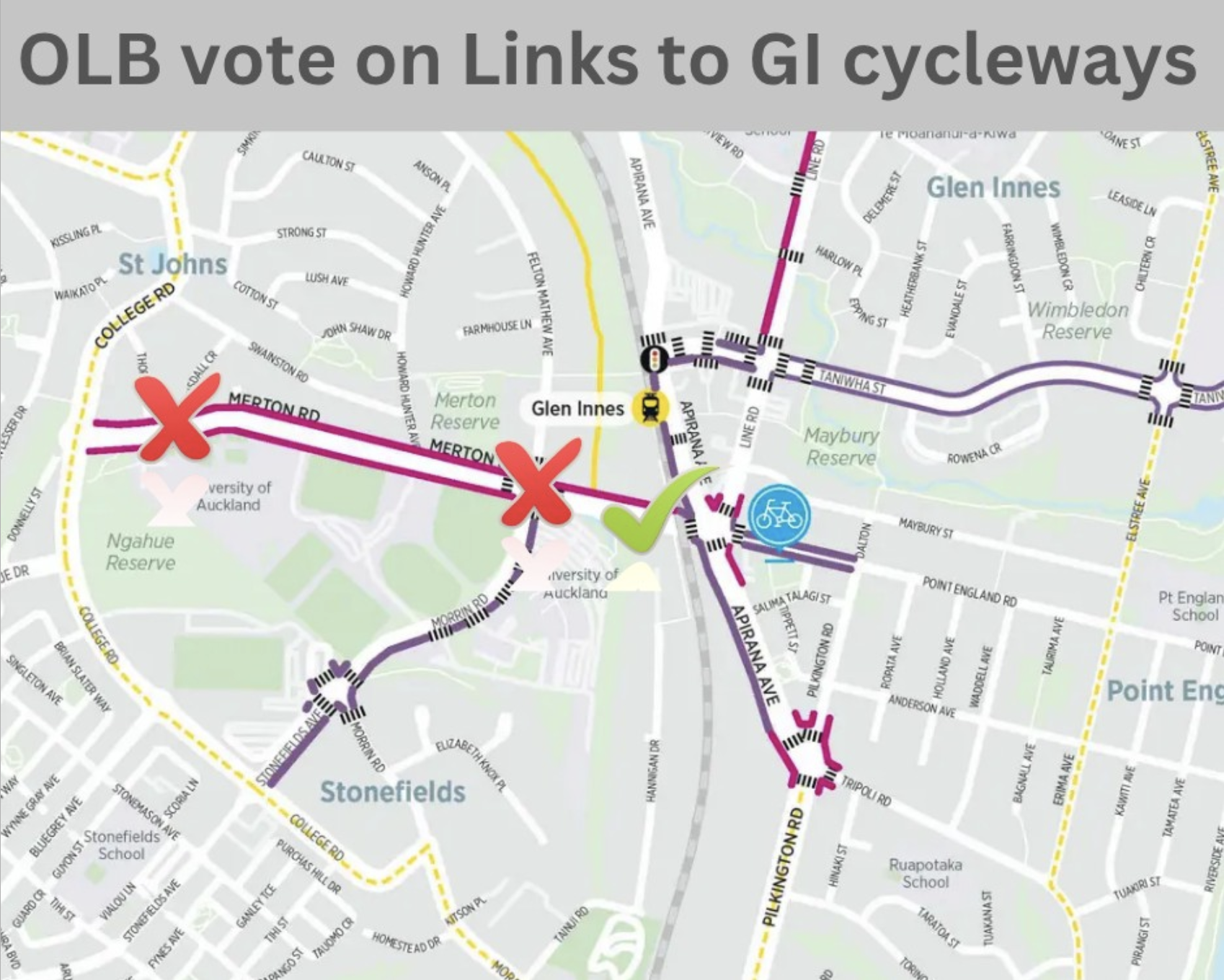
Speaking of which, Bike Auckland also reports that Ōrakei Local Board has backed away from two key parts of a ten-year project to deliver safer cycling links around Glen Innes. For unclear reasons – and in split decisions – the Local Board voted against raised crossings at the Merton Rd roundabout, and against the protected cycleway on Merton Rd West from College Road to the roundabout. The blog post offers advice on how to change their mind.
Te Ara Hauāuru – Northwest Busway info sessions
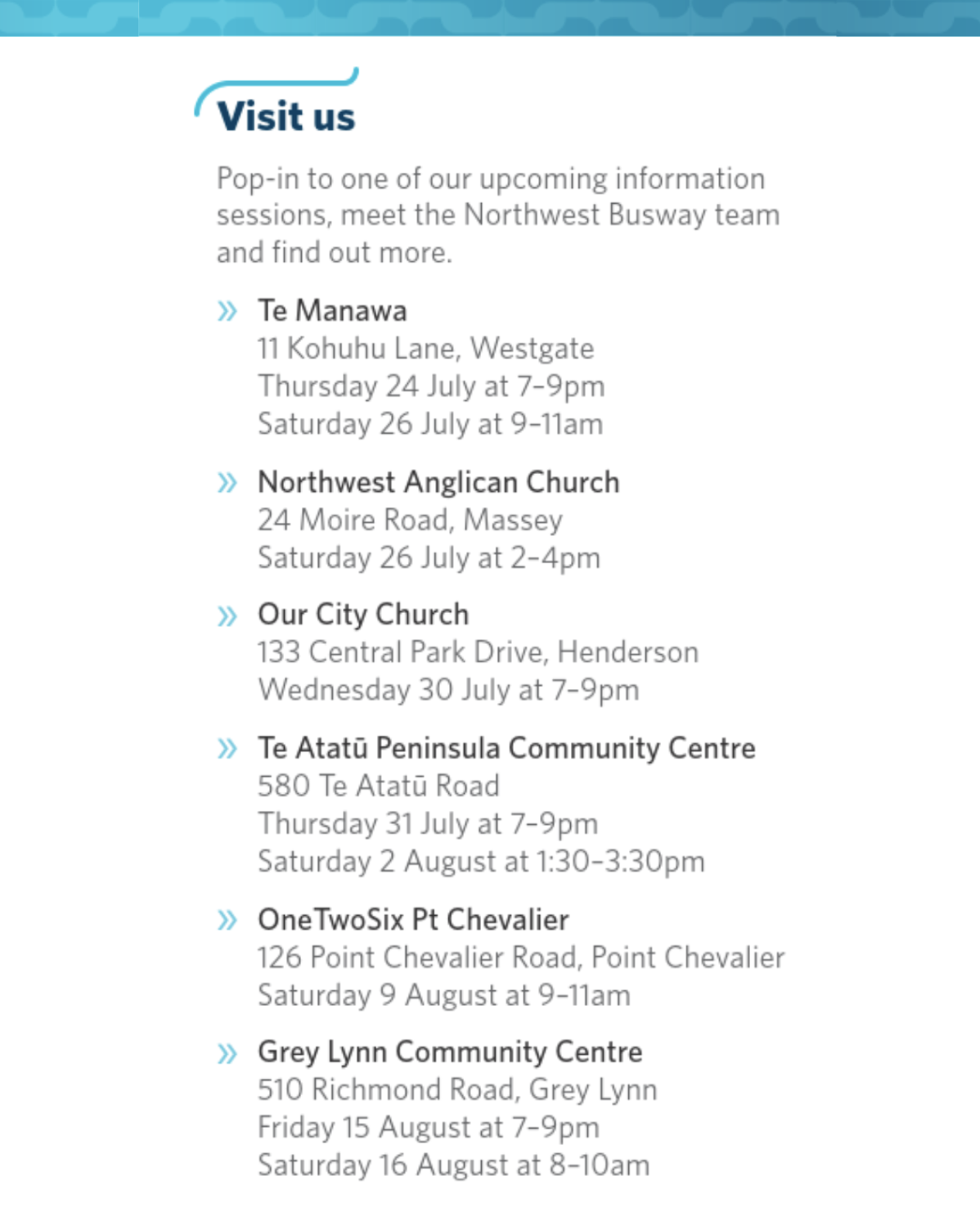
NZTA is running drop-in informational sessions over the next three weeks on plans for the dedicated Northwest Busway (and seven bus stations) along SH16, from Brigham Creek to the city centre. Find out more about the sessions here.
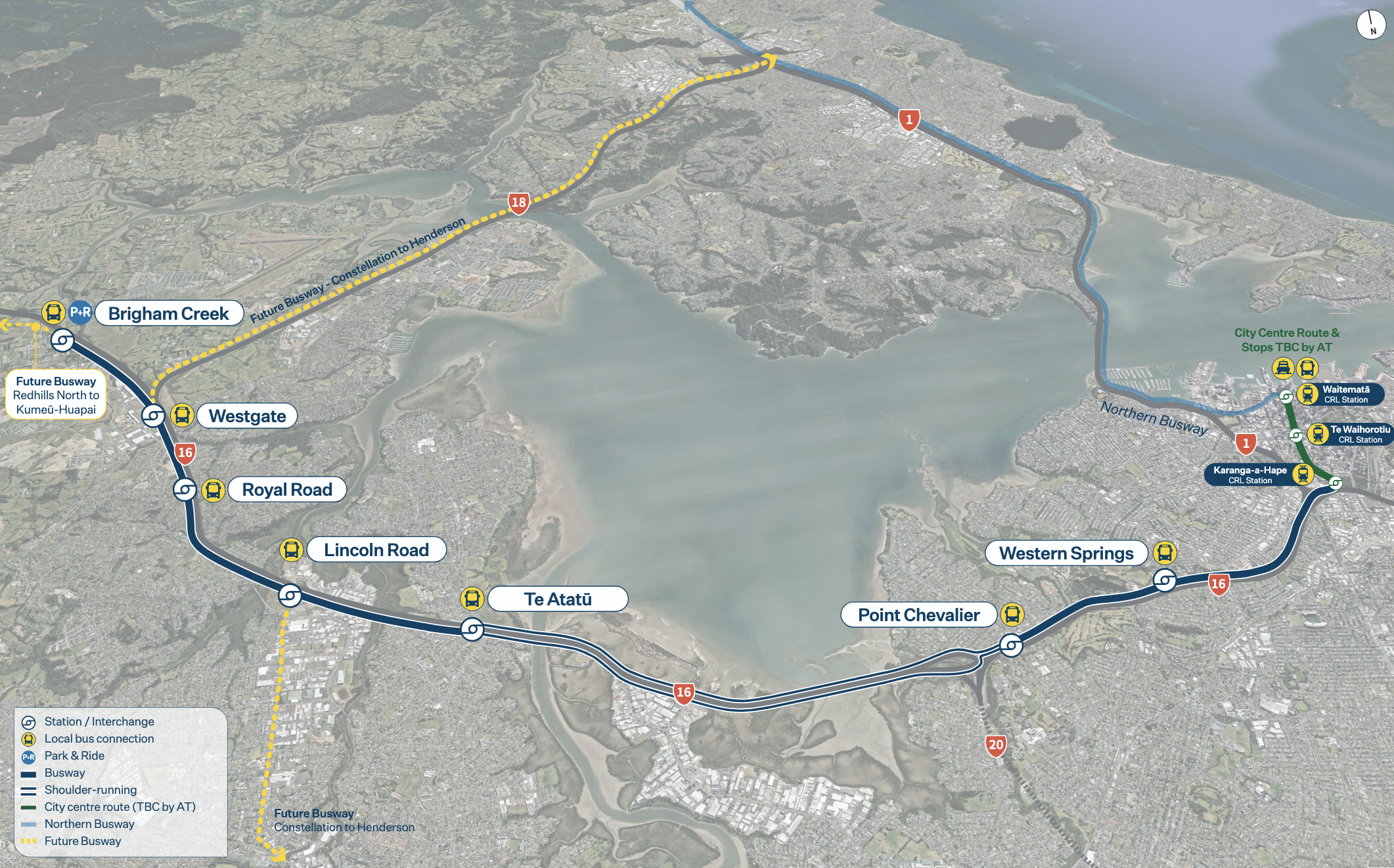 Map of the planned NW Busway as of July 2025, via NZTA
State of It (cont.)
In the wake of the Committee for Auckland’s State of the City report (covered by Patrick here), Professor Tim Welch of the University of Auckland confronts the cost of underfunding our “primate city”. In a nutshell: “Auckland isn’t a problem to be managed, it is an asset to be leveraged. Every successful developed economy has learned this lesson.”
If the phrase “primate city” gives you visions of King Kong clambering up the Sky Tower, here’s the definition:
The concept of the primate city was formalised by geographer Mark Jefferson in 1939. Such cities are defined as being “at least twice as large as the next largest city and more than twice as significant”.
Auckland fits this definition perfectly. With more than 1.7 million people, it is over four times larger than Christchurch or the greater Wellington region. The city accounts for 34% of New Zealand’s population and is projected to hit 40% of the working-age population by 2048.
Auckland contributes 38% of New Zealand’s gross domestic product and its per-capita GDP is 15% higher than the rest of the country’s. Its most productive area, the central business district, enjoys a 40% productivity premium over the national average.
To economists, these numbers represent the “agglomeration benefits” research shows primate cities generate. It is the economic effect of combining businesses, talent and infrastructure.
Yet New Zealand systematically under-invests in the very place generating this outsized economic contribution.
Related: in an RNZ article on how Auckland can get its mojo back. Subash Chandar K (maths teacher and Local Hero of the Year) makes the case for affordable public transport, and architect Pete Bossley has his eye on the near future:
Bossley hears the regular complaint that the CBD of Auckland is always under construction. He wants to remind those naysayers that those changes, such as the pedestrianisation of Queen Street and the 2026 opening of the underground City Rail Link, will be brilliant.
“People often dismiss Queen Street as being terrible. I think it’s one of the great streets. It’s just beautiful how it meanders its way up the valley.
Newsflash: “Nice to haves” are nice to have, which is why it’s nice to have them
Last Saturday saw the opening of the replacement for the Jubilee Bridge in Panmure, reconnecting access across the Basin. The old bridge had reached the end of its lifetime in 2023, and the new bridge, Te Kōpua o Hiku, looks great, is three times as wide as the old one, and features new lighting. Its name reflects local history:
Te Kōpua o Hiku/The Deep Pool of Hiku refers to the deep pool beneath the bridge, once occupied by Moko-ika-hiku-waru, the lizard-fish with eight tails who is the kaitiaki taniwha of the people of Ngāti Pāoa.
While the current paths around the Basin are narrow and busy with walkers, there’s plenty of future potential here for a properly walkable/ scootable/ bikeable connection between the Eastern Busway and Sylvia Park. An easy win for active modes.
 Image of Te Kōpua o Hiku: Auckland Council

 A couple of nice pics of the new bridge by Luke Christensen, via Twitter
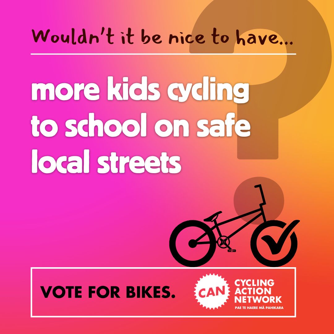
We’re also digging this local election campaign by CAN, the Cycling Action Network. Who defined “nice to have” as something we can’t have? Bikeable streets, swimmable beaches, clean air, energy independence, functioning libraries – these things are nice to have and fundamental to healthy, resilient places where people want to live. So let’s be having them.
The ongoing toll of speed reversals
July 1 was the deadline for the coalition government’s speed reversals, initiated by Simeon Brown and delivered by Chris Bishop. As we’ve covered in detail, the new Speed Rule was rolled out under the banner of “productivity”, disregarding evidence, and in many cases against the wishes of communities and in ways that actively undermine local aspirations and major investment.
Usually it takes a while for the impacts of new policies to become clear. In the case of road crashes, it also takes time to discern the multiple contributing factors. That said, the evidence is clear: as speeds increase, so do the risks and the consequences of any crash.
So we are simply noting for the record that so far this month, there have been four deaths (that we know of) on roads where this government mandated a return to higher speeds. Our hearts go out to everyone affected.
- On Friday 4 July in the evening, a person died after a crash between a car and truck on SH1 near Motutere south of Taupō. The road between Turangi and Taupō was closed for several hours. (This stretch of SH1 between Motutere and Hallets Bay was reverted from 60kmh back up to 100kmh on 1 July, following consultation – Updated: it seems the particular location of this crash may have escaped reversion, for reasons unclear).
This stretch of highway has seen multiple crashes over the years, with a 2022 crash turning the lake red, and a 2023 crash requiring two 12-hour road closures to retrieve a logging truck and associated debris.
- On Saturday 5 July just after 1pm, a 68 year old man in an electric wheelchair was hit by a vehicle on Burnett St in Ashburton, and subsequently died in hospital. (It appears that Burnett St was part of a 24/7 30kmh zone around a nearby school. At the beginning of this school year, in response to the new Speed Rule, Ashburton District Council reverted its 30kmh school zones back to 50kmh, with variable 30kmh speed limits for short periods only on school days).
- On Saturday 19 July around 6pm, a person died in a single-vehicle crash on SH6 near Okaramio, between Renwick and Havelock. The crash brought down power lines and the road was closed overnight. (This stretch of SH6 was reverted from 90kmh to 100kmh on 1 July.)
- On Tuesday 22 July, a person died when their motorcycle was hit by a car on SH1 near Manakau, between Ōtaki and Levin. The road was closed for at least four hours, school pick-ups were disrupted and a nearby marae welcomed stranded travellers in. (This stretch of SH1 from Ohau to Manakau was reverted from 80kmh to 100kmh on 1 July following consultation).
Oh hey there, so, we had a fatality on our stretch of State Highway 1 today after Simeon put the speed limit back up to 100. After all the years it was at 80 with no fatalities. A life ended. SH1 closed for 4+ hours. We told them it would happen.
— Belinda Whyte (@beebrhyte.bsky.social) 2025-07-22T08:31:53.461Z
As RNZ reported on the day, this wasn’t the first crash in this area since the speed reversal:
Ngāti Tukorehe Tribal Committee chairperson Pikitia Heke said pleas to keep the stretch of highway near the local Marae at the 80 kilometre speed limit had “fallen on deaf ears”.
Heke said she drove by the aftermath of one crash shortly before hearing of a second that closed the road on Tuesday.
“When the speed limit went down to 80kms we didn’t have any fatalities on our road. There wasn’t any significant crashes on our road and then – as soon as it went up – there’s been two crashes today that I know of,” Heke said.
She said the Iwi had approached local ministers and held protests in opposition to raising the speed limit but to no avail.
“It’s dangerous. There’s a lot of sharp turns, over-bridges. When you go over the over-bridges in both Kuku and in Manakau you can’t see because they’re on hills and they’re turning at the same time. So there’s no real clear vision. Unless you know where you’re going – or know the road – it’s unsafe really,” Heke said.
A follow-up report from RNZ yesterday notes that two local marae, Wehi Wehi and Tūkorehe Marae, are now spearheading the call for a return to safer speeds. Watch this space.
Wehi Wehi Marae sits right beside the highway and [Alice] Miratama said it had a big impact on how the Marae operates.
“We have our kaumātua that no longer walk to the Marae it is just too unsafe for them, we don’t allow our tamariki to walk home from the Marae it is not for them. But the biggest fear we have for Ngāti Wehiwehi is that we have a Kōhanga Reo on our Marae.”
The road was just too unpredictable to have tamariki walking along it, she said. It also caused worry when the Marae hosted any kind of hui.
“Our pae taumata are constantly running out there, that is one of our tikanga to go and make sure that our manuhiri that are standing at the waharoa are safe. But is it really safe?
“It’s gotten to the point now that we’ve had to seriously think about how do we look after our manuhiri, they’re contending with cars that are going at 100 kilometers an hour on the road and we have to make sure that their safety comes first before our karanga has even gone out.”
 Image: Alice Miratana, via RNZ
Keeping the trails open
RNZ reports that the national cycle trail’s “Great Rides”, an economic powerhouse for tourism and regional towns, need a plan to keep them maintained and open:
Maintenance funding for the country’s ‘Great Rides’ trails will need to double in the next decade, or some will degrade so much they will lose that status.
The trails generate just under $1b annually in benefits to regional economies, drawing about a million cyclists and walkers each year.
The government puts $8m a year towards the trails through the International Visitor and Conservation Levy, with contributions totalling $129m since 2009. Councils have co-invested at least $60m into the rides in that time.
But an Official Information Act response from the Ministry of Business, Innovation and Employment, released to RNZ, shows an estimated $160 million will be needed to maintain and enhance the Great Rides over the next 10 years.
Per year, it is double the amount currently allocated for the network.
Speaking of what will be a great thing to ride, Te Whau pathway continues to make progress:
And further around the Harbour, the cranes have arrived to start the final section of Te Ara Ki Uta Ki Tai – the final stretch of the Eastern Path that will link Orakei Station to Tamaki Dr with a boardwalk.
Council planners at their wits’ end as government pauses plan changes
In The Spinoff, an anonymous council planner discusses the impact of the halt on plan changes ahead of changes to the Resource Management Act:
The one key thing I really want people to take from this is: whether or not you think the RMA is broken, whether or not we need RM reform, and what form that reform should or shouldn’t take, there is literally no need to have a blanket pause on actually managing our resources while that happens.
Our politicians, across the spectrum, need to get their shit together and land on a workable, lasting RM system that we actually get to implement, rather than living in this bonkers limbo for the foreseeable future. Our environment, our economy and our lives literally depend on it.
Getting to grips with the big issues
Physicist (and frequent e-bike commuter) Professor Richard Easther of the University of Auckland tackled one of the big questions about the universe this week – explaining to RNZ’s Emile Donavan how journalist Jonathan Milne’s forgotten coffee cup managed to stay on the roof of his vehicle for some time, even while driving.
“Crucially, the coffee cup was full… [but] the other thing is it seems like Jonathan Milne drove commendably carefully for that half kilometre. The faster you drive, the more drag force from the wind; and it sounds like he stopped and started very delicately.
The two limits here, if we’re going to be formal about it, are [firstly] that if you accelerated suddenly there would be some point at which the cup would start sliding, and in general once you start sliding… you keep sliding. And [secondly] he also obviously didn’t go too fast. If he’d gone too fast, the drag forces would have pushed the coffee off the car.
It’s also a tribute to Auckland traffic, which by moving slowly is out there keeping safe the coffee cups of the Fourth Estate.”
On that note – enjoy your coffee or tea or whatever keeps you going on a Friday, and have a great weekend!

 Processing...
Just FYI the NorthWest Bus Info session for Te Atatu are at 595 Te Atatu Road – the Community Centre . NZTA commented on their fb page to rectify the incorrect address given but have not changed it on their post or their webpage
Thanks, Vinny!
I’m hoping someone’s going to do a post that explores:
– the impact on Pollen Island and nearby ecological areas, particularly with the intention to Fast-track the sensitive bits, and
– the impact on the NW Shared Path users during construction.
Because there is a good way to do this, but it’s not the way busways tend to be designed and built in Auckland.
Thanks Heidi – yes as someone who rides daily along the shared path from Te Atatu towards Westgate there is some concerns here, and of course Pollen and Traherne Islands are extremely important and vulnerable.
I think the proposal is to do nothing on the causway, the buses will continue to use the shoulder lanes as they do now.
I do not understand how money functions, but what is the cost of busways versus the cost of medium sized apartment builds?
As a CITY, could we not focus on more CITY things?
Or are we to continue to be this hybrid rural urban mess that the motorways created?
If our council can work with Wellington Politicians to push the apartment agenda, we could all be living in a far more liveable city, far further into the future.
bah humbug
What is liveable about forcing people to live in inner city boxes? Auckland has a lot going for it but most of what makes it a great place to live is outside the Central Area.
The are plenty of places in NZ people can choose to live in a standalone house, is that’s what they want. It’s not a form that works in a city. Indeed, the traffic created by the standalone housing form is the main downside to Auckland. It’s unfair or impacts people living in central apartments, who would otherwise enjoy the joys of a washable city.
Washable, lol. Our rain ensures that. Sorry for multiple typos.
miffy doesn’t seem to want any attempt to be made to improve things. i wonder how miffy feels about suburban sprawl, deforestation and the loss of good growing soils?
I came across this video the other day Showing the History of the Rail tunnels under Auckland’s CBD which never happened ;-
https://www.youtube.com/watch?v=b1bvzZUSYBA
I think this was the video david trying to post I think?
https://www.youtube.com/watch?v=b1bvzZUSYBA
Hello, I’m the person who made the video. Appreciate you posting it here. There are a few videos on the CRL on YouTube but none of them really went in depth or mentioned the prior proposals so I decided to theme my video around it.
That’s great, Sam! Super to bring all that footage together, and great commentary too. Thank you.
Good video – thank you for putting it together.
And here’s where Council got to yesterday on banning helicopters from residential areas: https://www.rnz.co.nz/news/national/567955/auckland-councillors-agree-on-desired-helicopter-saga-outcome-but-not-how-to-get-there
Glen Innes highlights some of the problems with how local democracy operates with strategic planning. Do Board members realise that the roads crossing the railway cannot accommodate all the cars that may want to use them? Bikes, buses and trains are the only answer going.
What should be left to Local Board and what to TRICS?
Can Deliberative Democracy be given a better place in resolving issues like this?
Yes although I think the problems you outlined are so basic, it shouldn’t need deliberative democracy. Just competently designed processes of an orthodox kind.
And yet the plasma for the revamp of station access (removing the pedestrian level crossings) involve entirely removing station access at one end of the station – incidentally right beside the old Tamaki Campus, which is planned for huge residential development…..
From memory in the five years that SH6 between blenheim and Nelson was lowered from 100 to 90 there were 1 or 2 fatal accidents total.
Speed limits put back up to 100 and just 3 weeks later there is a fatal accident
In the period after speed limits were reduced on this stretch of SH6 between Blenheim – Nelson, deaths and serious injuries fell by over 70% (in contrast, there was virtually no change in DSIs on the similar section of SH6 south of Nelson over the same period). And still that wasn’t enough for people to vote for keeping them…
All my sympathy to Anonymous Planner. Chris Bishop seems to want a better new system so much that he can’t allow the old system to be made better years before his new ideas might have some effect. Just look back at how long AUP review has taken up to now. Remember that anything Consented before a Plan Change becomes effective can still go ahead.
“Auckland … GDP per capita is 15% higher than the rest of the country’s.” Infometrics reckon that in 2024 Auckland’s GDP per capita was 9% above that for Hamilton City and slightly over half the figure for Wellington City. The real point here is that treating the rest of the country as an undifferentiated lump makes no sense.
Regional GDP is almost always a load of BS (and local GDP even worse). How do you allocate income/spending for firms that have a head office in one place and a dispersed workforce? They invariably get that wrong by allocating it all to the office that dies the reporting.
KiwiRail Collusion With AT To Block Community Access To The Railway North Of Swanson
Monday, 14 April 2025, 1:28 pm
https://www.scoop.co.nz/stories/AK2504/S00477/kiwirail-collusion-with-at-to-block-community-access-to-the-railway-north-of-swanson.htm
Seems to me investing $16 million per year for $1 billion return seems a good return on investment. Better than any highway project by far.
Also announced this week is consultation on a cycleway and partial bus lanes on Vincent St between Pitt and Mayoral
https://haveyoursay.at.govt.nz/vincent-street
As western buses move back to using Albert/Vincent St for city access later this year, has anyone seen the plans for Albert St between Wyndham and Wellesley?
Speaking of changing plans for betterment, this blog has previously mentioned getting another stop added to the NW busway in Massey North/Old Westgate (near the Woolworths and yellow cycle bridge).
The amount of people that would be added in walking distance would be large and it would reduce the heavy car dependence on old Westgate (the new bus station in NorthWest is pushing it distance/timewise for most especially elderly/children/disabled.
It would be a lot cheaper to design and build it now rather than retrofitting it later on.
Can GA make a push for this?
Possibly verging on ‘Old Man Yells at Cloud’ territory, but is anybody else having a bit of trouble interpreting the road markings on the Great North Road as it approaches the intersection with Ponsonby Road?
Hopefully a temporary state of affairs (this part of the road is being upgraded for bus and bike traffic) but recently older road-markings (showing lanes etc) have been ‘moved’ to new alignments. Unfortunately the contractors have done such a poor job with both: (i) removing the old markings; and (ii) replacing them with fresh ones; that it’s really hard for me to tell which is which.
Hopefully this gets resolved as I think its slightly dangerous.
Not with that particular road as I haven’t been there recently, but I feel illegible road markings are very common in Auckland.
Yes agree and I think there are a couple of elements at play here- one is the poor visibility- in certain weather conditions some of our markings are very hard to make out, and positioning of markings, often some of our turning arrows etc are covered by one single car at a junction so we get drivers making sudden changes when they realise they are in a lane that does not permit them to turn they way they want to go.
Te Whau pathway looking nice.
…and so is the Panmure Jubilee Bridge replacement, especially in this drone footage at night of it:
https://www.youtube.com/watch?v=dSaSTcgfBzU&list=PLZ_efadIXTD8x4JW-k1hQs3idEk4jvs2p