Auckland Transport could start reallocating road space as a standard design solution – but may need the Board’s help.
Waka Kotahi, Auckland Council and the Auckland Transport Board have all directed Auckland Transport to improve active and public transport options by reallocating roadway space. It’s a far cheaper approach than the property purchase and extra construction that widening road corridors entails.
4 lanes vs 4 lanes pic.twitter.com/VlJLbLZdJc
— Infrastructure CGIs (@InfraCGI) May 9, 2022
And Auckland Transport seems to welcome the idea too. They recently presented to the Planning Committee that road reallocation is a key part of a more cost effective approach:
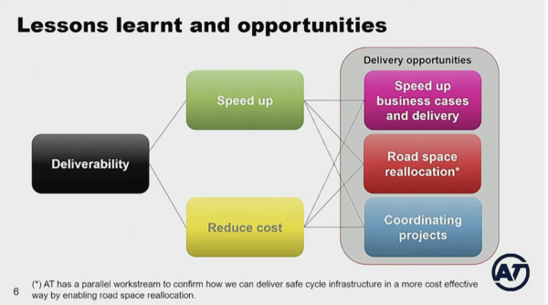
It’s often a different story at project level, though. Why?
Van Ness
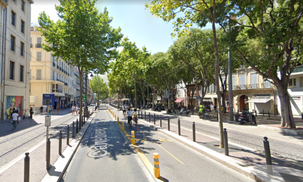
Let’s start with some inspiration from San Francisco. A new busway was opened there early last month, created by reallocating general traffic lanes:
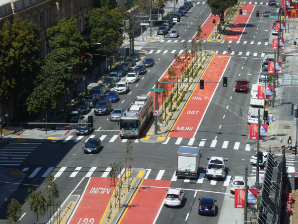
Bus Rapid Transit in the Van Ness Improvement Project, San Francisco. Image Credit: Pi.1415926535 via wikipedia.
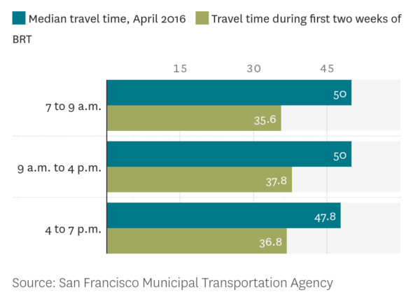
The project has been successful: bus reliability was apparent in data from the first week, and the bus time data from the first month is impressive:
The project would have been quite different if the planning methods of even a few years ago had still been in place recently. Road reallocation would have been predicted to deliver “poor travel times and reliability”, forcing the project towards costly and destructive road widening to keep the traffic “flowing” – even though it was already on a super-wide corridor.
The changes that made this project possible without road widening started with a law change in 2013. California added a legislative requirement to update the transport planning processes, and changed the key metric for evaluation to the reduction of vehicle miles travelled (VMT).
From consultant GHD’s webpage, Are you ready for California Senate Bill 743?
Response to this legislation change was patchy initially:
certain regional review processes sometimes still prioritize automobile lanes even at the possible expense of BRT potential.
So in 2018, the California Department of Transportation (Caltrans) developed guidance directing that:
coordinators and functional reviewers will transition away from using delay based analysis, such as level of service or similar measures of vehicular capacity or traffic congestion, to determine the impacts of land use and infrastructure plans and projects.
Instead, they will identify opportunities for reduced vehicle miles travelled generation, advise Lead Agencies on maintaining safe operations, and provide recommendations on developing location‐efficient… land use… this report also endorses person throughput as an impact metric for proposed BRT routes under Caltrans jurisdiction…
(Emphasis in bold is mine, and I also spelt out some acronyms in full.)

The Van Ness Bus Rapid Transit. Image credit: Lea Suzuki, San Francisco Chronicle
Do we need stronger guidance too?
In New Zealand, we’re a few years behind on this same journey. Progressive programmes are happening within all the agencies; reducing traffic volumes and increasing people throughput are recognised as important benefits. But installing these as the actual metrics in the evaluation process, to replace level of service or vehicle travel time savings, would highlight the benefits of sustainable projects: cheaper street-level light rail would be favoured over tunnelled light rail, for example. We’d start to see projects being delivered that provide substantially higher benefits at a far lower cost, including many more bus lanes and cycle lanes. The destructive intersection widening programmes would also finally come to a halt.
But isn’t vehicle travel time still important?
Yes, but experience has shown that concentrating on easing traffic flow locally also induces more traffic, which clogs up other areas of the network. It’s ironic, and instructive, that the best places to drive – Amsterdam and Copenhagen, for example – have been focusing on giving people excellent active and public transport choices.
The Eastern Busway
In A Proposition for East Auckland, I outlined what’s at stake with a project that’s on the cusp of gaining consent, the Eastern Busway Phase 3. This is a much-needed project, but so much has changed since the project was conceived: much of the cost of $867 million is for property purchase and extensive construction that is quite unnecessary, and the high vehicle volume outcomes are misaligned with current policy.
The question is what should Auckland Transport do now? It’s the sort of question we’re going to be facing a lot as our planning changes to create the low-carbon systems we need.
Widening the road corridor creates intersections and streetscapes that are fundamentally hostile to people walking and cycling.
There are advantages in changing the design to fit within the existing road corridor, as I laid out in my earlier post. They are significant: money would be freed up to fund complementary treatments throughout the wider area. Road reallocation and area treatments together would reduce traffic and improve safety significantly throughout the network, meaning the benefits of the investment are much larger and more equitably spread. This would enable many more people to access the new busway and cycleway, and deliver easier end-to-end journeys for freight. It is also likely to bring forward the completion date.

“In order to fix the climate and to make cities achieve their goals, cargo bikes and cycle logistics need to pertain steady and strong growth.” – Autonomy.
At this point in time it seems wise to go back to the drawing board for at least the section that isn’t yet approved, east of the Ti Rakau Bridge. And we know the design isn’t set in stone: the plans changed to include a deviation near Burswood Drive recently.
The Planning Paradigm Problem
So what is it in the planning process that leads Auckland Transport to road widening rather than road reallocation?
At the core there is a systemic problem with how vehicle volumes and travel times are calculated, which in turn impacts the calculation of the project’s effect on emissions, public health, safety and agglomeration.
To help describe how this occurs, it’s useful to note that the size of a typical low traffic neighbourhood (left) is similar in the size of a typical zone used by the strategic model (right) for this part of Auckland:
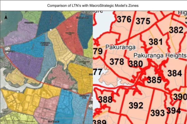
This makes it easy to visualise the sorts of trips that happen within a ‘model zone’ – they are the same sorts of trips that happen within a low traffic neighbourhood, which I’ve tried to describe in my earlier posts about the Eastern Busway, Low Traffic Neighbourhoods, and the local commercial and industrial districts.
In East Auckland, with the busway design changed to include road reallocation and area treatments, there would be changes in “land use” and in people’s “travel behaviour”. People would take many short trips, often within one model zone, or between adjacent zones. Many trips would “evaporate”, as more non-drivers become able to walk and bike independently, so their family members don’t need to drive them.
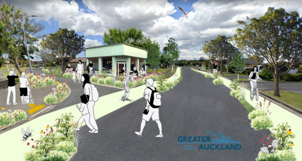
A corner cafe near Ti Rakau Drive, and safe ways to get around for people on small wheels. Illustration by Emma McInnes.
The model used doesn’t acknowledge any of this: not the land use change, nor the extensive behaviour change response to the safer environment, nor the effect of children’s independent mobility, nor the trips that occur within a model zone, nor the trip evaporation.
As a result, the model overestimates the traffic volumes on Ti Rakau Drive. It was simply not created or calibrated to be useful predicting this level of change.
The Options Analysis
This brings us to the options analysis that Auckland Transport have recently undertaken, in response to the public feedback. The public had given ‘mixed views’ about the allocation of road space, so Auckland Transport looked at an option that involved some reallocation: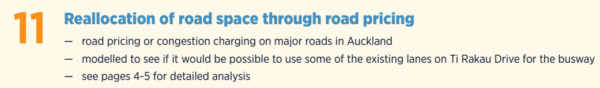
It’s good their analysis included road pricing – but modelling the effects of pricing requires some nuance.
The results of the analysis paint a dire picture for the reallocation option, with multiple imaginary problems, which all stem from the model’s overestimation of traffic volumes:
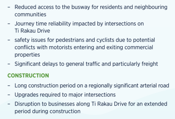
For a project costing $867 million, this options analysis should have been a check using different principles.
Auckland Transport needed to explore why there’s such a difference between:
- what they are being directed to do: road reallocation and a very large reduction in transport emissions, and
- what they are proposing: significant road widening, and an unpopular deviation that requires the loss of many homes.
As we can see from the Van Ness project, reallocating road space for a busway significantly improves bus times and reliability. Even if the model predicts “significant delays to traffic” this doesn’t need to stop the project. Modelled vehicle travel times are not accurate enough to use as a metric in the evaluation.
How can the Auckland Transport Board help?
Ideally, good outcomes-focused governance can create an environment in which everyone involved in the project can play to their strengths.
Targets: The Board should be giving direct instructions and targets for reducing vkt and emissions.
Metrics: The Board should be clear they expect Auckland Transport to move away from using level of service, vehicle travel time delay, or congestion as a metric in the evaluation. There will be experts within our agencies who can recommend appropriate metrics to help us achieve our strategic priorities.
The model: The Auckland Transport Board could directly seek assurances the modellers are comfortable with how the model is being applied by the planners. They could ask if it is being applied in line with best sustainable transport planning practice. They could also organise a review by an international expert.
The paradigm: The Board should broadly understand the shifts in transport planning paradigm underway internationally. They could ask if the organisation has shifted from a “predict and provide” planning methodology to “decide and provide”, which gives more flexibility to the designers to create the spaces we want without being constrained by having to “accommodate” fanciful traffic projections. They could check the engineers and consultants understand that reallocating lanes:
- leads to traffic evaporation,
- does not require “parallel routes” for the traffic to “divert to” – and indeed blocking parallel routes to ensure traffic does not divert there is useful for ensuring mode shift will happen instead.
Behaviour change: Designing the Eastern Busway to fit within the existing road corridor requires expert knowledge about behaviour change, and there are many experts on the subject within the agencies. One thing the Board could do is check that the decision-making structure within Auckland Transport allows the softer disciplines to inform the projects, and that they are not being sidelined by senior engineers or planners who don’t understand the role that infrastructure has on travel behaviour.
In summary
It’s understandable that the Auckland Transport Board would feel uncomfortable about the project’s design being changed at this late stage. However, revising the project seems to have few downsides in the current budgetary environment. It would be better, cheaper and quicker to deliver, with the potential for bringing forward the opening date.
The benefits to the Board go well beyond even this, however.
Auckland Transport is facing budgetary and other pressures, and are currently seeking ways to trim budgets and achieve better climate outcomes. There are many projects in their programme of work which would benefit from taking a road reallocation approach, to reduce emissions, DSI, project costs, and renewals costs. The dynamic lanes on Maioro St project indicates the organisation’s focus on “traffic flow” is preventing all-mode safety or city liveability, and there’s been nothing to suggest that upcoming projects like the Whangaparaoa Bus Access and Carrington Rd Corridor will be focused on reducing traffic volumes, increasing children’s independent mobility or keeping intersections as small as possible for safety.
The benefits would be considerable, but a paradigm shift would be required. The Eastern Busway is the perfect opportunity to trial the new approach; the benefits to residents, environment, business and budget are so clear. So the time to act is now. If the Board is unsure of how to proceed, they should reach out to international experts.

Image credit: Doug Gordon @BrooklynSpoke

 Processing...
How does this leave the A2B Busway which basically has vacant land to build on for 75% of the length, the cost must be much more reasonable than the Eastern Busway? Why isnt this project being massively accelerated with climate change etc
“…see if it would be possible to use some of the existing lanes…”. Absolutely bizarre language – of course its possible. Why are these people still allowed to persist with demonstrably wrong models that dont account for changes in demand?
Great article Heidi
Thanks, Scott.
I have got nothing against reallocating a lane or two but could we elevate it or build it in a trench so the buses don’t have to stop at all the signalised intersection. It could sail along at 80 kms an hour between stops while traffic crawls along 50 kms with long waits at each intersections. The worst part of motoring out there is to get past the congestion around the town centre so can we have peak express buses from the suburbs that bypass it and proceed directly onto the busway and onto Panmure. This is not like the Northern busway there is not going to be a park and ride at the town centre as far as I know. Off peak buses can run through the town centre.
The whole point is that reallocating a lane is a miniscule cost compared to expensive flyover/unders. Especially when a higher top speed in between fairly closely spaced stations is probably worth very little in terms of time saving
Exactly. Didn’t Greater Auckland cover that in an article a few years ago?
If the station spacing is ~800m, reaching max speeds of 80km/h only saves 10 seconds compared to reaching max speeds of 50km/h.
The gaps between Pakuranga Station, Edgewater Station, Gossamer Station, and Burswood Station will each be roughly 800-1200m.
Or we could just program the traffic lights to be green when the bus arrives?
Auckland has had that technology for 20 years
Where is it used in Auckland?
That seems like pointless and wasteful overengineering Royce, when (as Jak & Riccardo mention below) active priority traffic signals for buses already exist.
I would hesitate to put so much emphasis on peak express buses, especially peak express buses that bypass a major town centre such as Botany. It’s a flawed operating model which will no longer work with the impact of the pandemic and the rise of work from home. Public transport needs to cater to all-day trips beyond the “morning/evening office commute”, and that better suits the high-frequency hub-&-spoke routing philosophy.
Besides, a properly designed and operated Eastern Busway should result in plenty enough time savings for regular all-stop services, with separation from private vehicle traffic and intersection priority. Reallocating road space more fairly would in all likelihood solve the town centre congestion issues for buses too.
For any feeder buses going to Botany Town centre there would be 4 signalised intersections in the last mile. So pretty slow then you get at least another 5 or 6.when you get on the busway hard to see much upake on such a car culture as east Auckland.
Again, Royce, I emphasize. Active bus priority traffic signals.
Technology that detects oncoming buses and changes the traffic lights so that buses always have a green light. It’s proven technology overseas, for both BRT and LRT, and could be easily implemented here.
That would easily solve your concern, without the need for expensive grade separation.
And yes, the main busway services (plus the future A2B) should be going *into* Botany Town Centre, not just the feeders. In fact, Botany station should be as central as possible. Why would you want a station only on the edge of all the retail (and potential future residential + mixed use) where people will be wanting to go?
Again Matt terrible part of town to many traffic lights best avioded.
That’s hardly an argument Royce, unless your priority is “traffic go zoom zoom” instead of “how can we design transit to best get people where they may want to go.”
Part of the importance of road reallocation is to ensure the 4 signalised intersections in the last mile are as small as possible. Fewer lanes and less general traffic means shorter traffic light cycles. Even the pedestrian phases can be shorter, as the crossing distances are shorter.
The current design expands all the intersections, and slows everybody down, including the buses. Indeed, this is one of the reasons given for the Burswood Deviation; to avoid those delays.
Okay you want argument then I think it needs to be grade separated like the Northern Busway. Bus priority won’t be good enough to get the average east Aucklander out of their jam tin. We can blame Manukau City Council for building it like it is. And the Northern busway has got park and rides I just don’t think it’s going to work in the same way. For start there is less people working in the City centre than the shore and another change at Panmure or stay on the bus and endure a slow trip through Newmarket. So we need a one seat ride from home to Panmure with bus priorities for all buses accessing the Botany Town centre wether their on the busway or not.
Royce – grade separation would be expensive to construct and create a visual blight – an unfriendly environment for pedestrians cyclists and transit users. Unless you really need capacity in excess of 12,000 people per hr per direction I don’t think grade separation is required.
If your concern is travel time – again, active priority signals that turn green for approaching buses will do wonders. The travel time from Botany to Panmure will have already decreased thanks to the protected busway.
If your concern is getting people out of cars – the way to do that is taking away general traffic lanes. Reduced demand – look it up, it’s a well proven strategy overseas. You don’t need gold plated transit to get people out of cars, you need both a reasonably sized carrot AND a reasonably sized stick.
Park n rides long term aren’t a good transit philosophy either, especially inside urban areas; they should be replaced by feeder buses and higher density walkable development. Only real place where P&Rs are genuinely useful are right on the urban edge and in more rural areas.
I cannot tell what your argument is over bus routing and transfers. From the information given out by AT so far the East Auckland bus routes would remain much the same, possibly with more frequent 70 services between Botany and Panmure for connections to the Eastern Line trains.
Royce – the bus route that already uses Te Rakau Drive is the busiest route in Auckland outside of the Northern busway, it already has no trouble coaxing people out of their cars without park and rides. The busway is all about making it quicker and more reliable thus attracting more passengers.
Of course it would be even better if it were fully grade separated like the Northern Busway but the costs would be enormous, especially if stations were also going to be above or below the ground.
Great article. I think this is exactly what Auckland needs. Reallocate space, have full time bus lanes everywhere. I far prefer this model to over and under engineered bus ways that are getting built now.
100% agree. If not full time bus lanes, at least 6am to 8pm or something.
I suppose between 8 pm and 6 am there’s insufficient traffic to warrant changing the buslane to a general traffic lane, and 24/7 lanes makes it abundantly clear.
Thanks, Jak. As I outlined in https://www.greaterauckland.org.nz/2021/11/01/liveable-arterials/
we won’t manage bus lanes on all our arterials. There are other approaches we’ll need to use to improve the bus priority and reliability.
Ti Rakau Drive certainly has the space, though. And the great thing is that if we reallocate space to bus lanes in the places where we can, rather than widening the corridor to do so, the reduction in traffic in the network has a knock-in improvement for those arterials where we cannot have bus lanes.
It must be difficult inside AT AT the moment,what they have done in the past,is no longer,fit for purpose. Most rational people inside the organization will understand that. Adding a dogleg to the busway,and demolishing houses might have looked good once,but now should be considered as social and climatic vandalism.
Surely a, carbon generation output during construction ruler, is being applied to such projects,if not,why not.
Separate,but related,sand miner off Parkiri,has been knocked back on sand extraction, Auckland Council and AT should be looking at projects that improve,but do not require vast amounts of natural resources to be dug up, road reallocation is a neat answer to this.
“no longer fit for purpose”
Staff with outdated knowledge and skills just need to move on. Forcibly if necessary.
AT seems to be focussed on “building stuff” and having constant restructures, that replace experienced people with junior ( ie cheaper ) staff.
If AT was serious about “behaviour change” it would tell the Council that it is going to introduce new bus lanes on 50km of main arteries each year.
However these projects are delayed by wimpy Councillors who don’t want to reduce the number of road side car paring spaces, in case they upset the owner of the local wine shop or florist.
Grant Robinson’s statement the other day made perfect sense in this context. We simply can’t afford to make the level of change people want, we need to figure out how to make the best of the infrastructure we have. This is a great example of that.
And yet ironically Grant Robinson’s still supporting highway-building projects and irrationally expensive transport options (tunneled light rail and a road+transit AWHC tunnel) that will prevent optimization of surface transit infrastructure in Auckland.
Grant Robertson is making excuses for not being able to get anything done.
Great article, as always. I’m stunned that one of their identified (imaginary) downsides to road reallocation is the safety of pedestrians and cyclists… as opposed to the current utopia of Ti Rakau Drive?? My irony meter just exploded.
Because AT is locked into the idea of keeping the same number of general traffic lanes, so I imagine they’re presuming road reallocation would mean a narrowing of the footpaths or something.
Or just using it as an excuse.
A lot of the AT higher ups do not seem to understand that road reallocation is literally increasing the capacity of a road corridor. There’s abundant evidence that bus lanes, cycleways, and footpaths carry more people per hour than general traffic lanes, and that reduced demand works as a means of getting people out of cars and onto alternate transport modes.
More and more I can see the real ingrained systemic bias towards cars in mainstream Aotearoa politics and media.
Great article. The Eastern Busway is a project for the next 100+ years but it’ll likely only be the first ~10 years of its life that take place in an environment without road pricing. Once road pricing happens there’ll be significant disincentive to drive at peak times and the busway will be there as a good quality alternative. Crazy to design on the assumption that travel behaviour won’t change (or doesn’t NEED to change).
Great article Heidi. Auckland needs more viable continious bus lanes & priority improvements, by relocating new & extended ones on exsisting lanes of the Roading network. A lot easier & cheaper than expensive property purchases. Makes maximum of roading transport infrastructure & modes of travel.
I guess someone has to be the Ludite here. I can conceive of many normal family travel needs that simply cannot be effectively met by public transport. Example: sports practice. Kids often travel several kms. Seldom is it near public transport routes. And when it is, it is so infrequent. Coupled with families not considering it to be safe for youngsters to be walking the streets and waiting at bus stops in the dark. And then there is the impact that this waste of time has on homework an family time.
Consider also game day. Private transport might be 20 to 30 minutes across town each way. Public transport for the same journey could add upto 2 hours at each end with multiple route changes.
There are many other examples. Nothing I have read deals with transport as it applies to communities in a wholistic way.
Then take the car? Its not a zero sum game: we can have good PT and you can continue to choose your car for the trips you need to.
Most of your issues are about quality of current service and coverage, not that good PT for those trips isn’t possible. We have chosen to provide rubbish PT, its not an issue with PT itself.
Agreed
John, if PT was fast, frequent and safe enough to meet many family travel needs, wouldn’t you prefer that? It’s not a pipe dream either, there are cities overseas both bigger and smaller than Auckland that manage this.
It can be all these things. We even have good examples here in Auckland – Northern busway is the standout as a starter.
The current crapness of public transit for these trips is not representative of what it would become with these kinds of projects or other upgrades to the rapid transit network (like a Wairau valley station)
There’s a few things you’re missing.
1. More people traveling by public transport makes it easier for those who still must drive to get around too – because there’s less traffic on the road. And less traffic requires less lanes.
2. Public transport will be improved. There should be higher frequency services (half-hourly frequency ought to be a MINIMUM for local bus routes), and more bus lanes. With dedicated right-of-way and better headways, transfers and travel times will become much quicker.
3. The NPS-UD should enable more housing and services (shops, schools etc.) to be built near public transport or within walkable neighbourhoods. It will make it possible for more people, kids included, to safely walk, cycle, or catch transit to get where they need to go. The more people who can use these modes of travel, the fewer cars will be on the road and the less general traffic lanes will be necessary.
Concern trolling on the assumption that public transport and urban density will not grow and improve is unhelpful.
“ More people traveling by public transport makes it easier for those who still must drive to get around too – because there’s less traffic on the road. And less traffic requires less lanes”
Haha. Easier to get around with less lanes and less traffic. That’s a good one!
Yes, thank you Tim! It is a good one, because it’s true.
Just google Reduced Demand.
Less traffic on the same lanes is easier to get around.
Less traffic on less lanes is the same as it was before. Dur.
Bold of you to assume that “less” is always a 1:1 ratio, Tim.
Did you look up reduced demand and read the evidence?
Bold if you to assume that 1/2 the lanes will equal less than 1/2 the traffic.
Whatever happened to cars expanding like gas to fill the available space?
Network, Tim. Reducing the number of lanes on one corridor reduces the traffic there. It also reduces the traffic elsewhere, because trips don’t just include that corridor. So everyone’s trip becomes less congested on the start and end legs even if it remains similar on the corridor itself.
And what I laid out in A Proposition for East Tamaki is using some of that money saved by not widening the corridor on area treatments, which themselves reduce traffic further. The effects compound.
In terms of understanding ratios, this might help: “each 1% increase in highway lane-kilometres typically increases total vehicle kilometres (#vkt) by 1.2%” – Congestion in Highways when Tolls and Railroads Matter: Evidence from (545) European Cities, 20 Mar 2021.
https://papers.ssrn.com/sol3/papers.cfm?abstract_id=3785888
*Tui add.
Ah yes, the classic car-brain argument to being proven wrong.
You got no evidence on your side Tim, admit it. Colloquialisms don’t count.
Citing a study then claiming the opposite is also true is evidence now is it?
And will also be wonderful when we reach a point in time that we consider the implication of all those kids sports travel. I used to ride my bike to school on Saturday morning where I met my fellow riders ( sports gear in our backpacks) we would then be loaded on school van to be taken to away games, or even ride to away games if close enough -and the ride was a great warm up.
I don’t like to knock back good principles. Reallocating space has to be the first choice – where there is enough space to do it. But we need to see some real idea of how the space that there is could actually be reallocated workably. Traffic evaporation is a good tool, for a start, but can only go so far. Especially difficult in the political/social atmosphere of the Eastern Bloc. How much of the existing traffic can be taken off Ti Rakau Drive?
Having done that, there are some key destinations to service: Pakuranga and Botany centres. Routes to and from these are needed that don’t interfere with busway performance.
The real time and space management problem comes at intersections. Buses need to be detected and let through – and this has to work for buses in both directions. Then people on foot or bike need to be able to cross safely without long delays. Then there needs to be space for other vehicles to wait while all this happens, and those vehicles need to make whatever turns they should.
Buses need a certain width of lane; trucks on freight routes need a certain width of lane; people on foot or bike need a certain width of path. Then safety buffers, platforms, rain run-off management and trees need their space.
Let’s see some drawings of what you think could work.
And don’t get me started on wherever the centre of ‘Botany Centre’ really is.
‘Where there is enough space’? Have you *seen* the roads out there?
I think you mean you don’t like to knock good projects. I agree. That’s why I’ve been saying throughout that this project is extremely important. But if it can be vastly improved, at lower cost, ensuring other important programmes aren’t cut, then we have a responsibility to do that. This is too expensive and disruptive a project not to put it under scrutiny.
If there is not enough space to use road reallocation in this generous corridor, then we might as well pack up shop and head to the pub.
“Traffic evaporation is a good tool, for a start, but can only go so far.” But how far is so far? There are many levers in the toolkit. Many have been acknowledged, but most aren’t used. The point remains that inaccurate calculations of the level of traffic evaporation possible has informed AT’s planners and engineers. This puts them in a difficult situation. Their intentions are good. Nobody wants a dud project. But due to this persistent flaw in the calculation, and the misconception it has built up in the sector, it must feel risky to attempt to take a new approach. And that’s been the case forever: so AT have no experience in knowing how far “so far” is.
Someone needs to lead the sector away from this problem. Luckily, none of this is rocket science. The Netherlands worked through these concepts in the 1970’s and 80’s. Other European cities did so in the 1990’s and 2000’s in their SUMP plans. California did so in the last decade. We can do this.
Yes, you’re right about intersections. AT need a complete overhaul of their traffic stacking approach. Auckland Transport tends to increase the number of lanes at intersections where the most people-friendly cities will reduce them to create better pedestrian safety where it’s most required.
I think it’s more appropriate for AT to seek second opinions from climate planning transport consultancies… or the ITF or EU or C40 or somewhere, than rely on volunteer advocates for providing drawings… but if you really think I need to do so, can you confirm that and I’ll see if I can get some funding from somewhere.
We could easily do the same thing that Sacramento did on Van Ness Avenue. But first we would have to widen a city street to six lanes like they did, then we could reallocate some of them like they did. Which street should we widen?
Sorry I miscounted. The photo shows something about 9 lanes wide. So I guess the only candidate is Lincoln Road because that is the only place AT has been daft enough to get consent for something that stupid.
And even Van Ness would’ve been widened if they hadn’t changed their metrics. At the other end of the spectrum, much narrower streets than even our 20.1m wide arterials (as you know, smaller than Ti Rakau) have been reallocated to sustainable modes. It’s not what you have, it’s what you do with it, remember.
I included a few other example pictures; do you need more?
What you are aiming for a busway effects what you do. If the Eastern Busway is expecting 40 buses per hour bus priority signals will mean many buses have green lights. At 200 buses per hour many buses will have reds as lights cannot be continuously green. At this frequency you would need to invest in an overpass /tunnel if you wanted to maintain travel speed.
I feel the Northern Busway should aim for a maximum of 15,000 per hour per way. At less than that there is room for improvement before a second harbour crossing. This will be consistent with this post theme- the reduction of vehicle miles travelled.
At 200 buses per hour you also need 4-lane busways to cope…and if you’ve got that sort of demand you’re better off building some form of rail based transit, which have higher capacity at lower headways and in the 7-8m width of a 2 lane corridor.
I think the Eastern Busway and A2B would inevitably require conversion to light rail or metro in the latter half of the century, once they reached capacity and urban density increased in their surrounds. There’s still probably an argument that A2B should be built as light rail from the start, rather than a busway.
The *third* harbour crossing must be designed for light rail ready for when the Northern busway hits the realistic limits of that mode.
At a minimum. What Matt said.
+1 A good rebuttal which is what the conversation needs. Too many cars on Gossamer Drive – how quickly can we reduce that?
Thanks. It’s a good question. Quite quickly, and doing so would really improve the area. The exercise would require creating a proper traffic circulation plan for East Auckland, based on turning everything into low traffic neighbourhoods and improving the streets that bound them. Gossamer Drive should only be access to the neighbourhoods between Pakuranga Drive and Ti Rakau Drive, not a through-route.
Hi, just a point of clarification. The Van Ness corridor project is in the city of San Francisco, CA, where I live. The city of Sacramento, CA, is the state capital, about 120 Kms from SF. So, not in “Sacramento, San Francisco,” but simply “San Francisco.” Either way it’s a great project, but it unfortunately went WAY over budget and WAY over time, due to the usual factors that complicate big infrastructure projects, plus the pandemic, of course.
Hi Kevin, thanks for that clarification. I’ve corrected it now in the post. I see I misunderstood one thing I was reading which was actually referring to Sacramento Street, and my geography of this part of the world is clearly not up to scratch. Sorry about that.
We often have over-budget and over-time issues, too, and ongoing supply chain issues aren’t going to help. I believe this one was also talked about and reconceived many times over decades.
Keen to hear more if you have the time.
Hi Heidi,
I wondered if Sacramento St, one of the dozens of streets that crosses Van Ness, might have somehow muddied the geographical waters, so mystery solved.
As to the factors that put this particular project over its budget and timeline, what we see on the surface is a small part of what was achieved here. All of the underground infrastructure was also replaced, including sewers and utilities. And what the city thought was underground was frequently not what they found. SF has been rebuilt many times, most famously, of course, after the 1906 earthquake and fires that destroyed much of the city as it then existed. So it is not surprising that the records of what lay beneath this significant thoroughfare were not as accurate as thought.
Van Ness is also a very densely built street, with high-rise office buildings, apartment buildings, civic amenities such as City Hall and the major arts venues, plus hospitals and multiplex cinemas all sharing its trajectory.
It is also a designated US Highway (101) for much of its length, creating the major north-south link for the densest part of SF, and eventually leading on to the Golden Gate Bridge at the northern end of the city.
So, it was actually a huge undertaking on so many levels, apart from the wonderful new bus infrastructure we are now enjoying on the surface.
Thanks. Interesting. So many parallels. We have a lot of infrastructure rebuilding that gets counted in sustainable mode projects, too, and the media then treats the modes as expensive when they are anything but.
Is managing the traffic during construction also a big cost in SF? We seem to need to keep traffic flowing as smoothly as possible throughout, compared to some places where they take the approach of closing the road to get the job finished as fast as possible. This affects our projects in multiple ways: they take longer, the temporary traffic management costs are high, increasing the cost of the project, and because they’re high, there’s a pressure to reduce that cost – which is done by compromising safety instead of by closing roads to speed the whole thing up.
Good article and interesting comments.