I cycled along the Eastern Busway from Panmure to Pakuranga on Friday. It is a nice cycleway: comfortable, intuitive, and with some nice views, particularly from the bridge.
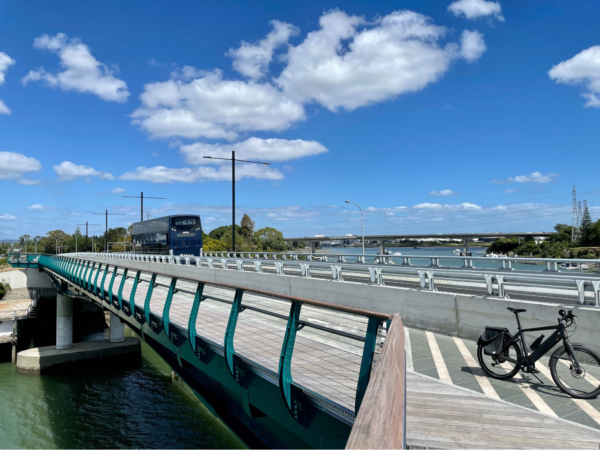
A whole new active modes bridge for bikes, boots, and buses.
The busway looked inviting, too – smooth and efficient. I love buses.
Busway, berm, bikeway. Three ticks green.
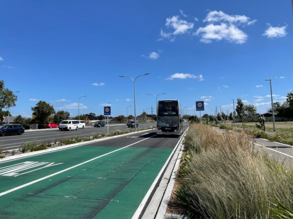
It was all surprisingly… short, though. I guess it was a short length of nice busway and nice cycleway.
There was a bit of a “bricolage” feel to it, like everyone’s dreams were included, but they weren’t quite sure why.
Busway: tick.
Cycleway: tick.
Lots and lots of lanes of traffic: tick.
Even more lanes of traffic at the intersections: tick.
Nice sweeping curves so the cars can go fast. Tick, tick, brrrmmm.
The people who managed to get the Eastern Busway to Pakuranga built had had to work hard to overcome strong business-as-usual resistance, and need to be thanked wholeheartedly for their persistence. We’re lucky they did: there’s now much more choice in how to travel in the area.
Still, the sheer incoherence of the planning is in full view. An integrated plan would have diverted the traffic away from the main street of Panmure. Instead, it’s swamped with fast, noisy traffic.
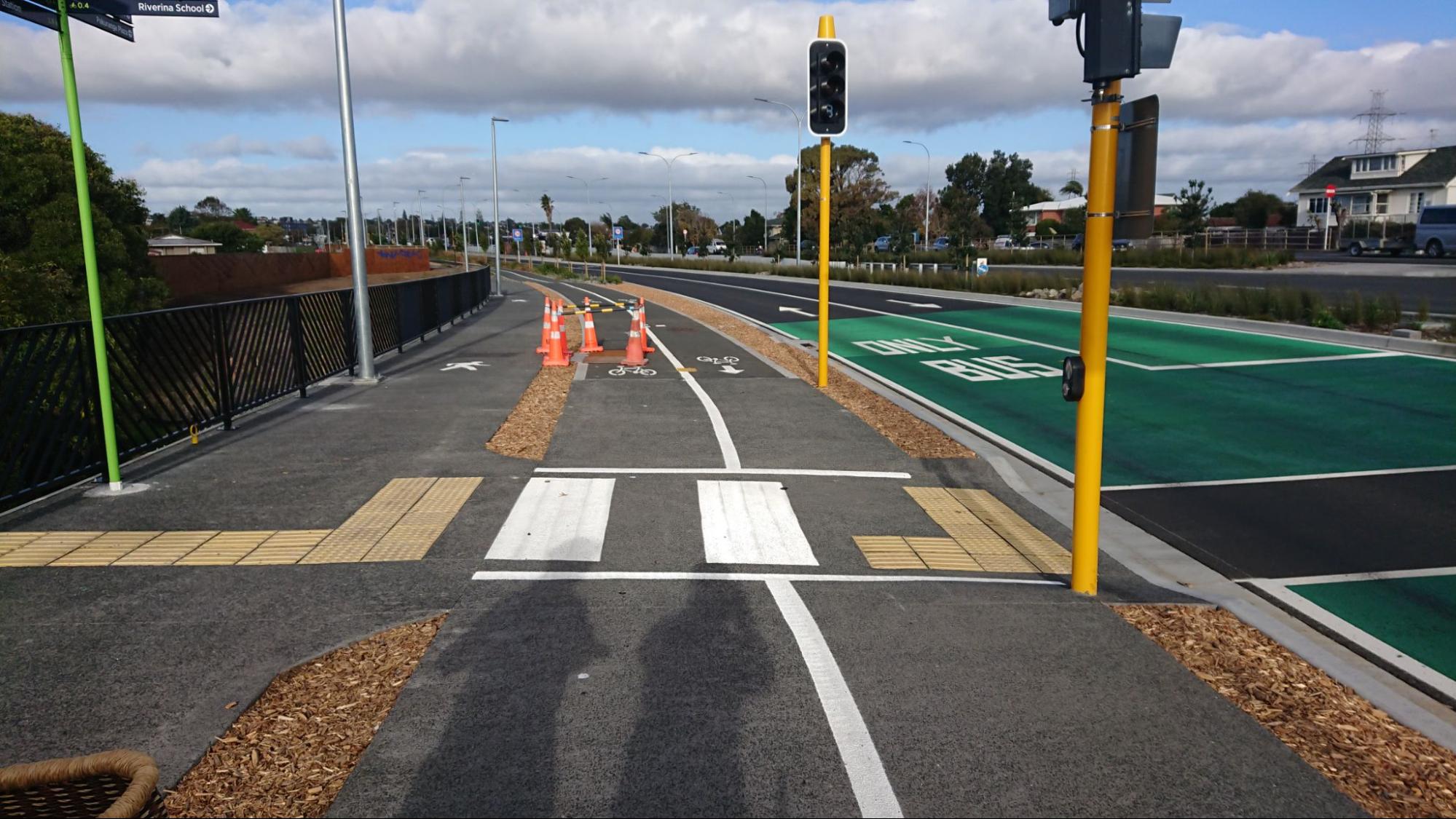
And when biking along the cycleway itself, the width of the corridor is quite overpowering.
Eastern Busway: mainly roadway.
Remind me again: why did we widen the corridor?
You wouldn’t widen the road corridor if your main focus was the bus network. Widening the road here – instead of reallocating traffic lanes – means that feeder buses and connecting buses are held up by more traffic elsewhere, reducing the quality of the public transport system.
Nor would you widen the road corridor if your main focus was the cycling network. The wider the road here, the more traffic throughout the network, and that means more bike-vehicle conflicts. That’s how people get seriously hurt.
You also wouldn’t widen the road corridor if your main focus was delivering a regional plan that delivered value for money. Buying up properties along a corridor uses money that’s sorely needed elsewhere, for all sorts of transport improvements. This was never more apparent to me than on Friday, riding along next to all the forlorn “half” properties left over from the widening.
It had shades of Christchurch’s Red Zone, but without the rural peacefulness.
The view from the bikeway: road on one side; half-properties on the other.
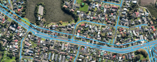
Before and after in one image. The earlier satellite view is overlain with the new Streetview line (the uppermost line) of the busway from after the project was completed. The line shows the scale of property take required; you can intuit the homes lost and the high public cost.
So why am I talking about this now? Time to move on, right?
I’m talking about the Eastern Busway because of two looming issues that coincide:
- Phase Three of the Eastern Busway – from Pakuranga to Botany – is on the cusp of getting consent to proceed, and
- Auckland Transport needs to vary the Regional Land Transport Plan (RLTP) – for budgetary and other reasons.

As anyone who’s ever attempted a home renovation knows, when finances get tight, there is always a silver lining – a budget-conscious rethink can lead to refinements that improve a project.
The key thing to know here is that this project has lots of public support:
There was support for encouraging active modes and cycling in particular, through the design of roads, paths, cycleway connections and station facilities. Suggestions have been made for improvements and further ways to encourage uptake at several points on the busway, walking and cycling paths and at stations.
So, we don’t want the Eastern Busway to suffer in this upcoming budget cut. The Eastern Busway is important – and it can be even better! Best of all, modifying the design now so it’s more sustainable could simplify the project so much that its opening date may even be brought forward.
This project could be adapted to become so transformative, so inspiring, that people will say, “That’s what we want here, too, please.”
And it’s an opportunity for our transport organisations to show what’s possible. It could mark a watershed in climate-appropriate and cost-effective transport planning.
Before I explain how, let’s take a look at the what: What’s the goal here? Let’s look forward in time… and take a peek at the people-friendly, planet-friendly future we could enjoy – within this decade – if this project is redesigned today.
East Auckland in 2030
In 2030, East Aucklanders feel their transport system is serving them well. All over the wider area, people of all ages and abilities have found new freedom in how they move about their day. The commuters and businesses along Ti Rakau Drive have been delighted to discover that the transport transformation is serving them better than the decades of old car-based planning ever did.
In 2030, children cycle and scoot at liberty, by themselves. It’s a short, safe walk or cycle to visit friends and favourite local places, and people enjoy the quietness and conviviality now there’s not so much traffic running through their neighbourhoods.
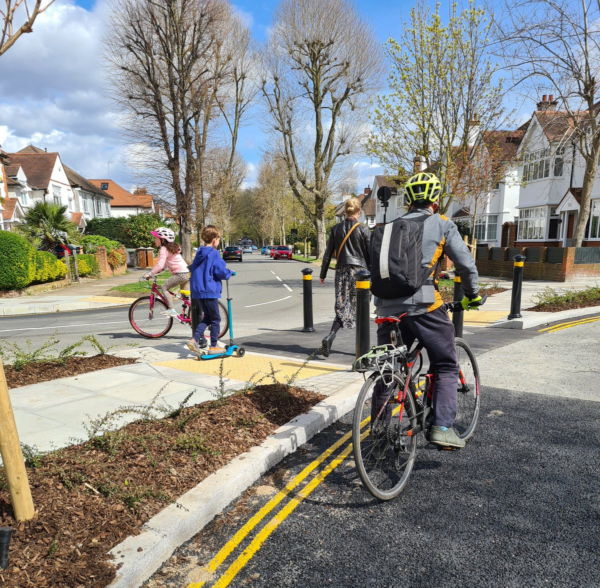
A modal filter in a low-traffic neighbourhood, improving access for people while keeping traffic volumes and speeds low. Image by Abundance London, via Twitter.
The cul-de-sac layout common in the area has been a boon, easily adapted by adding a few more bridges and other walking and cycling connections.
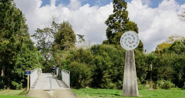
A bridge over the Oratia stream, easily adaptable for creating access in other Auckland neighbourhoods. Image: Greater AKL.
Local buses run every ten minutes, going wherever you want to go. And they’re reliable, because there’s so little traffic to compete with. For longer distance trips into town, or to connect with the trains at Panmure, the Busway itself is the preferred option for most people; far more attractive than being stuck driving long distances in traffic.
Car ownership has become a lifestyle choice now. Owning a car is no longer an unavoidable burden, and there are plenty of other things people choose to spend their money on instead. Shared cars are easy to use for when you do feel like driving somewhere. Local streets are almost empty of other motor traffic, so driving itself is much easier and calmer, too. It’s one of the beauties of changing the system comprehensively. After the first wave of disruption, even driving improves.
People live much more locally than before.
That’s because it’s nice to live locally. Residential street corners are great places to hang out, with more people walking and cycling past, and far less traffic. Many street corners have new amenities.
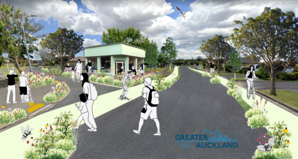
A corner cafe near Ti Rakau Drive, and safe ways to get around for people on small wheels. Illustration by Emma McInnes.
Little grocery stores and pharmacies. Coffee shops. Bike shops. Youth centres. Band practice rooms. Bistros and bars. Yoga centres and hair salons. Produce markets on land that was once just tarmac for carparks. Once people felt they could get around easily without a car – and once the planning rules changed to allow it, local amenities sprang up quite quickly.
Ti Rakau Drive also offers a more mature mix of economic activity. The commercial property owners there didn’t take long to realise that the real potential wasn’t in low-rise buildings and surface car parks. By 2030, more and more of these huge spaces are being converted into mixed-used developments: shops, commercial premises, recreational facilities, and apartments above.
Of course, this means the local opportunities keep opening up – for working, shopping, or whatever it is you do: sports, music lessons, or getting furniture upholstered. People in East Auckland enjoy the habits of using local services and shopping locally just like people do in any city with a healthy transport system. Once you’re walking to the bus, or biking around your local area, it’s easy to discover where the shops and services are, and to form connections with people and businesses. It just makes much more sense to stop in on your way somewhere, or to hop off the Busway on your way home, and do your errands locally before whizzing home on the fast and efficient feeder bus. Or on your securely-parked bike.
Other aspects of life that have changed include how people send, and receive, packages.
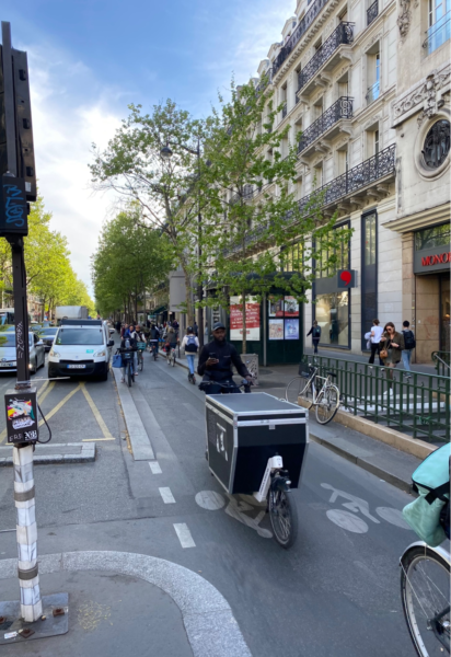
A delivery bike in Paris. Image by Jon Burke, via Twitter.
The once-ubiquitous courier vans are now rare. The logistics companies safely run e-cargo bikes throughout the area, which are way more economical than courier vans for most deliveries. Dropboxes installed in the local neighbourhood hubs have also been a game changer.

Image credit: Evri
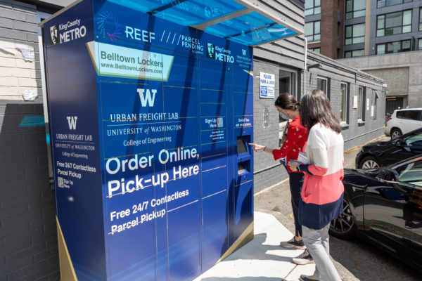
A Seattle Neighbourhood Delivery Hub. Image credit: Urban Freight Lab, University of Washington.
All this, and at a lower cost, too! And, everything I’ve described above can be achieved if we use two complementary approaches:
- Road reallocation, and
- Area treatments.
Road reallocation
When implementing bus and cycle lanes, reallocating lanes offers value-for-money that’s far superior to the eye-watering cost of buying up properties to widen corridors, which is why it’s been the preferred strategic approach for years:
- As long ago as December 2016, Mayor Phil Goff instructed Auckland Transport to use road reallocation
- In 2018, Lester Levy (then Chair of Auckland Transport’s Board) announced AT was boldly committed to doing so
- In 2021, Waka Kotahi’s (draft) Aotearoa Urban Street Planning & Design Guide clearly indicates that reallocating existing road space is recommended, rather than widening the road:

Looking at Ti Rakau Drive, where the road corridor is already 30 to 32.5m wide, you could take a “road diet” approach, in line with Waka Kotahi’s intervention hierarchy (which recommends “best use of the existing system ahead of new infrastructure solutions”). No need for road-widening here, when the existing space has plenty of room for:
- two lanes of central busway
- two lanes for cycling
- more trees
- better footpaths
- and two or three traffic lanes, depending on the location.
Not only does this achieve a safer and much more civilised street on Ti Rakau Drive itself, but the entire wider area will be better off – because reducing the number of traffic lanes like this also radically reduces traffic volumes.
This approach simplifies and improves the whole project, costing us less while delivering more:
- Far less property purchase is required, reducing property costs considerably.
- Far less construction work is required, reducing construction costs considerably (and reducing exposure to – and impact on – cost inflation in the construction sector)
- Side roads can also have fewer turning lanes – as they are catering to less traffic.
- All the intersections on Ti Rakau Drive can therefore be far smaller.
- All streams of traffic will see reduced waiting times – notably this will include the buses themselves.
- Safety would be achieved at a fundamental level rather than tacked on clumsily; it’s easier to make walking and cycling safe across smaller intersections and fewer lanes, and on streets with less traffic.
- And the Burswood Deviation can be dispensed with – as all the supposed reasons for it are resolved by the above improvements.
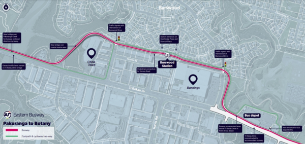
The Burswood Bump: no need for this deviation when you can make Ti Rakau Drive work more smoothly for everyone using it.
And, with less traffic, you have lots of room to increase the flow-rate of people along Ti Rakau Drive – because busways and cycleways have vastly greater capacity. There’s heaps of headroom for population growth here.

The cost of ongoing road renewals would also be lower, leaving more money in the pot for things like maintaining the bus shelters, and for feeder bus services.
The beauty is that scaling back the size of Ti Rakau Drive would save so much money, that the project cost could be reduced while also delivering the other big and crucial change required…
Area treatments
An integrated approach for revitalising the whole area would use low traffic neighbourhoods, plus treatments to make walking and biking safe along their boundaries.
#LTNs work because demand for short driven trips is *highly elastic*. This idea that all driven trips are inevitable gives rise to the fallacy of the 'sacrificial' main route. https://t.co/mfoDZOEZQ0
— Better Streets Waltham Forest (@WeSupportWFMH) December 23, 2021
:
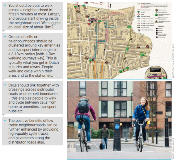
Here’s one possible layout. (Thanks again to the transport specialist who prepared it!):
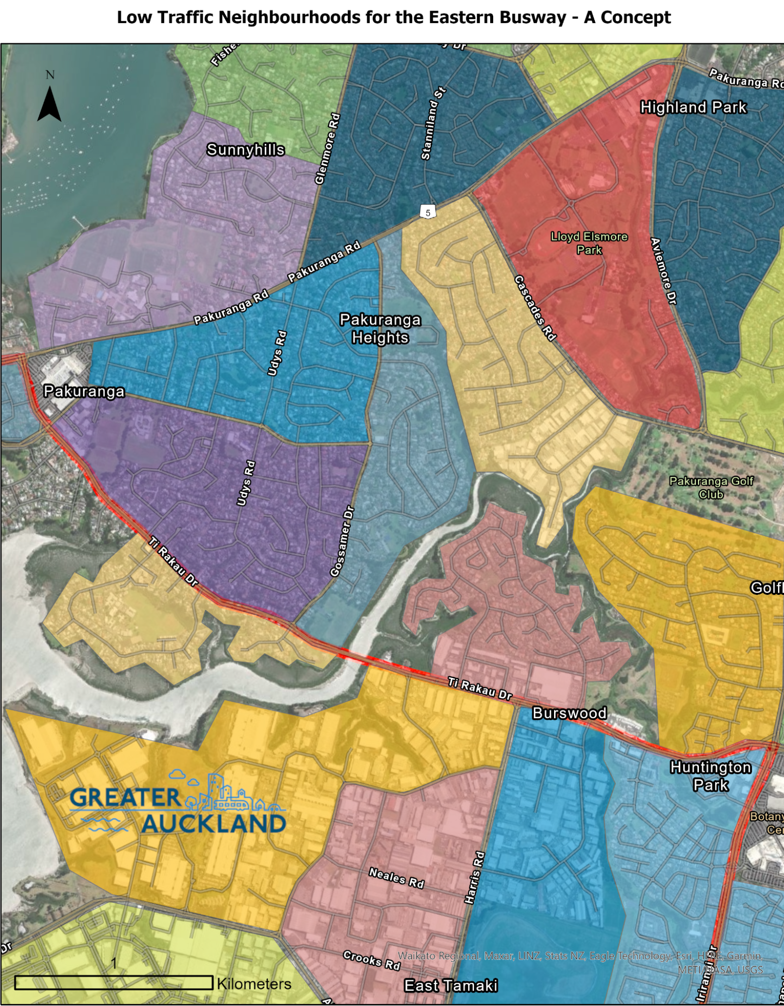
One potential layout of Low Traffic Neighbourhoods for the Eastern Busway.
Matt has suggested a city-wide programme for bridges would be helpful here, using a shared but simple modular design to reduce the delivery costs.

A few simple connections multiply the sum total of connectivity. Image: Greater Auckland.
I’ve also discussed how the industrial and commercial areas need these area treatments too, and I explored how one-way roads could help on the smaller streets which still need to fit large trucks:
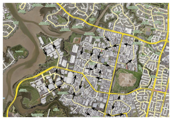
A draft circulation plan for industrial East Tamaki. Image: Greater Auckland.
So how do we make our way through this tricky moment, to the future painted above for East Auckland?
In my next post, I’ll get into the nitty gritty of why Auckland Transport’s analysis somehow keeps rejecting road reallocation as a solution here – and I’ll give some suggestions for how the Board can help break through this barrier, and turn everyone’s great theoretical intentions into excellent tangible outcomes by 2030.

 Processing...
Thank you! – well put-together. I found this a helpful video for showing what the Eastern Busway looks like (if I may?)
https://www.youtube.com/watch?v=6gRfsXZGstA
Such a rattly bus! Sounds like someone has a lawnmower running. Why are some buses so rattly? Could it be that someone with a screwdriver could fix that in a few minutes and make life more enjoyable for all?
That may have been a H&E Bus that was leased to Fullers on Waiheke as every bus that came over was serverly loosened on the Islands roads before beig sent back .
Two issue here:
-Need Bus traffic light priority.
-Need to fix the bus rattling.
Which comes to more questions:
-Why the traffic light priority not part of the project delivery plan? If it was part of the requirement than why the project manager didn’t plan it?
If it is not part of the requirement, than there is something very wrong with the design process. Did the designer really care about user experience and journey time?
The second question about rattling is also concerning. It shows the AT does not really care about user experience.
If your own car rattle and has an noisy uncomfortable ride, you will likely fix it or have somebody fix it.
The only people who doesn’t care to fix it is low socio-econ people who doesn’t care or have any money.
So do that means the PT service standard is only at low socio-econ level? If so how do they expect a high quality service acceptable to average people?
The accountability and operation of the of those AT and CCO is appalling. It needs fundamental restructuring.
Have to agree about the bus traffic having light priority. You wouldn’t expect a train to have to stop at a road crossing to let a couple of cars through – a dedicated bus route such as this should (to me) have the same principle.
As for the rattling bus, I guess I’ve just got used to it but you make a very valid point.
A system like this, crossing side roads more than once a km, without light priority is just silly. The bus should always have a green.
Yes all the double deckers seem to have that rattle, over battered road seal especially, just use the Northern Busway and had the same sounds.
The rattly bus is down to the bus company that owns and maintains it, not AT.
Hi
Completely agree with the 2 points.Imho project manager should be sacked aand or Auck transport should be held accountable or head of dept should be demoted !
That bus spent about 5 minutes doing the length of that busway, and about 1 of those 5 is spent waiting at traffic light. That is not a good show after what looked like a huge project. Also does part of that busway have a 30 km/h speed limit?
Those were temporary 30kms signs I think.
As a daily busway user, a significant part of the Pakuranga section remains 30km/h permanently. Which makes total sense because the road next to it is zoned for 60km/h.
I thought it was slow and narrow. After a billion bucks spend, I would have expected 80 km/h the whole way but it’s another snail. Why??
80 km/hr is way too fast for it given the length between each set of lights for starters. The buses would likely get bunched up & customers would experience uncomfortable acceleration and deacceleration.
Looks like someone forgot the 60kmh sign when the eastbound busway leaves Williams Ave station – the 30kmh is meant to be through the stations along the route, with 60kmh elsewhere.
Cool video. That bus way look like the prefect place to trial priority lights. A bus having to wait for three cars is ridiculous.
Did you notice that the cycleway gets no lighting. The roadway has lighting. The footpath has lighting but where the cycleway runs on it’s own there is no lighting. There doesn’t look to be sufficient additional lighting at the bus stations either.
Last time I looked headlights were compulsory on cars, buses and trucks so why do we supply them with additonal overhead lighting.
Next time you walk over the Hopetown Bridge consider who the engineers were thinking about when they installed the lighting.
So many little ways active modes are treated as second class.
So much of lighting in general is just serve cars rather than anything else. Loads of Auckland is weird dark too.
I agree in general but there is separate lighting I can see further along towards Pakuranga when the road lighting would be too far from the path. Ironically at https://youtu.be/6gRfsXZGstA?t=91 you can see a cyclist coming the other way on the main roadway (not much traffic that day though).
I love the idea of drop boxes. Why aren’t they integrated into railway station planning. On the ends of the buildings people order on line and pick up on the way home.
Didn’t they trial Countdown supermarket pickups in a couple of stations like Newmarket a few years back? Order online and pickup on your way home.
All that expansive width, with gold-standard for all modes, yet they still made the cycleway too narrow. Should be wide enough to have people ride side by side:
Oops, tried to insert an image but didn’t work. A Dutch (sorry) example of a bidirectional lane handling side-by-side cycling. Looks like it’s only a little wider than this new one along the Eastern busway: https://bicycledutch.wordpress.com/2018/05/08/traversing-boxtel-on-a-bicycle/
100%
Timmy I would say it is a very useful busway but there are additional aspects to be added before it was considered Gold Standard. Some of these are
-An 80km/hr limit rather than 30km/hr
– removal of traffic lights
– pre and post boarding payments
-Level platform boardings
“Little grocery stores and pharmacies. Coffee shops. Bike shops. Youth centres. Band practice rooms. Bistros and bars. Yoga centres and hair salons.”
Holy classism, Batman
This list spans just about the whole range of social class existing in New Zealand. Do you want to add helicopter landing pads to make it complete?
I’m genuinely baffled as to which class you think this list excludes when it has both ‘youth centres’ and ‘yoga centres’.
Everyone and every neighbourhood deserves diverse local shops beyond dairies and takeaways, no?
I’m curious – what would you add to the list (or take away)?
Its a massive waste of money really. I live on the isthmus, we have a semi decent bus system, but only because we have given almost half of our arterial road width to bus lanes. The capital investment is literally some green paint and signs, and until the half price fares, the operational cost was probably almost zero due to reasonably high usage and fares.
Its hard to know whether projects like Ameti are a necessary sprawl subsidy (buses have to be super quick because the distance is so far), or if it is a case of having your cake and eating it too.
Yep, a massive waste of money, to protect hallowed car space. Car drivers then turn around and complain about the cost of such projects.
Green, white and yellow paint, does not cost much. Some roving cameras even could even make it profitable.
And for those cameras, it would be really convenient if there would already be vehicles that regularly drive on those busways on a schedule.
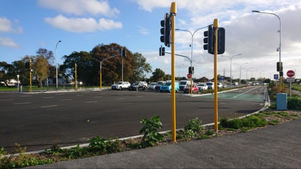
There are five traffic lanes in the eastbound carriageway at the intersection between Pakuranga Road and Ti Rakau Drive.
FIVE. In just one direction.
This is what happens if you prioritise vehicle level of service over all other KPIs.
Sorry, did they build gold standard cost bike infrastructure and not conect it to any other existing or planned infrastructure or even Train station?
I don’t live east Auckland so I am not that In the know. Will the Glenn Innis feeder network for the shred path build a link to this?
It connects to Panmure station (huge hub). I think there is vague plans for better cycle infrastructure from Panmure to GI. There is a bit from Panmure towards Mt Wellington but that putters out when it all gets too hard due to car priority.
That’s good to know. Google earth has dead zone before the station.
Sounds on brand. Given this is going to be extended south, a connection is really needed. Are the roads from Panmure to Glenn Innes the sort that you would let a kid bike alone, I imagine not.
It is infuriating to me that they build this sort of bike infrastructure, don’t build a pop-up feeder network (while the shared path is being built) or make any attempt to connect the network. A couple of km on horrible car roads, can mean people can’t/won’t use bikes.
Great post. I want to go out there during the morning peak to see it all in action. Was last there during a quiet Christmas holiday period, with COVID especially affecting tertiary student travel, there wasn’t really a March madness like most years.
Yes the project is very wide, the huge Panmure roundabout replacement is so big you feel you won’t make it time across to the other side before the light goes red when you are driving.
A road diet and all the other suggestions are a good idea. Love the idea of those e-cargo bike freight hubs.
You cant compare overseas to our public transport.
We are walking distance close to Botany, if we could get a bus every 10 minutes to catch the panmure train would be ideal. But we cant. So we bought a second car. Driving to the train is quicker.
If they made the busway only cycles we would feel safe riding a bike from botany to panmure.
NZ roading takes too long to build, isnt frequent enough and costs too much.
We have used the subway in new york the tube in london with no issues.
Yea nah, you can should Compare NZ to overseas transport systesms. We are not special.
NZs transport system is actively made worse by there being too many cars everywhere demanding far too much land and the power that be choosing to no reallocate space?
Is the number 70 bus an option? That is a true frequent line (sub 10 minutes peak I think) that interfaces with every train line in Auckland.
What? There is a 70 bus every 10 mins from the Botany Town Ctr all day and if you check now every 5 mins to Panmure if you include the 72C & M ones.
https://at.govt.nz/bus-train-ferry/#!/live-departures
Worth noting in the new half price fare ads the solution to an active crossing for the Harbour is to be a giant. https://imgur.com/a/Y9UEWxF
They removed over 100 houses to build the 1 km section of the bus way between the Pakuranga bridge and Pakuranga. That could have housed a few hundred homeless. Also, why not build the bridge for the 500 cars that use it every 5 mins rather than the 1 bus every 5 mins. The bus could have uses the old bridge and the cars could have used the new one. Also where in Pakuranga are all the park and ride car parks. Why not plan before spending the money on white elephants. A park and ride in Pakuranga alone would have been more successful at getting traffic off the road.
The bridge was built on that side for other reasons too.The pedestrian suitability for look outside etc would be much better with a new
modern bridge. What would it solve to have cars drive in the new bridge. Your non-sensical anti public transport bias is clear.
Quick fact check, it’s two buses every five minutes and about 200 cars. So the same number of people on each mode.
Difference is the road bridge capacity is full at this level, and they can increase to about ten buses every five minutes before the busway is close to full.
In other words, an arterial traffic lane each way can move about 1,500 people. A busway lane each way can move about 10,000 people.
Thanks so much for this post. When I visited the busway (on a bike) first time, I had an impression that there was too much concrete, it was too wide, overscaled. This post articulates why I felt something was wrong. Looking forward to the next episode!
Great post Heidi – at the end you allude to what is coming next, which will probably answer a lot of the comments / questions on this post. The history of this project is that there were never sufficient benefits from better bus / cycle travel times and experience to justify the costs of the project. The whole busway is justified (in B/C terms) by elements like the flyover providing some small TT savings to a lot of cars – that pays for the busway. The reason why the project isn’t taking lane space away from general traffic is because that would produce a massive disbenefit in the B/C calculations. Whether this approach to project appraisal is right is questionable for sure, but that is why the EB project looks like it does – any recent changes have been just tinkering around the fundamental premise that the business case doesn’t stack up if you generate lots of disbenefits to general traffic.
update from the future 2025…
NZ voted team car into power, now walking and cycling is being erased from the transportation menu. Simeon Brown and Maurice Williamson asking AT to remove the walking and cycling option to free up the car congestion…
https://www.facebook.com/SimeonBrownMP/posts/pfbid02rDKU1xmiDTMbnbadsR2bJ3h7FqjSjgNHvD4XAVEXPiE9fjUyaMaUjdaJw1qaxDf9l?__cft__%5B0%5D=AZWe30gbMqKohvtd_nhecczHAB8PhJhHnKA0m0YBCOQH0foSzNp5wdiJ6yOtE_mS08HUOvUS7H8uWMvr9iyHsRzsRo9VDg7BgaSI01ZFuYLXnMpaLH4VzTYWglJ8-Fmr7bbX-Ot7qPOOqG3ZDRmBBoF8TOWnf50xFpNP68myyMT7XQ&__tn__=%2CO%2CP-R