Imagine we stop driving cars so much.

Imagine having traffic levels like those in Level 4 Lockdown, when only essential journeys were taken by car – as a normal traffic environment.

Put on ice for a moment any doubts about whether we could or should do this… and let me paint a picture of our streets if we managed to do so.
This post is about the change enabled on the “arterial” and “connector” roads – the streets that will form the boundaries between low traffic neighbourhoods:

I believe we can recreate these streets so they become “liveable arterials”. I believe they can function much better for all the people that use them, whether they are on foot, in wheelchairs, moving freight, travelling by bus or bike or other small wheeled ‘micromobility’. As I said in Yes! We can do all those sorts of things, it became visible during Level 4 Lockdown that:
We can fit walking and cycling and buses and trucks and essential car journeys in the corridors we have.
What our corridors don’t have space for are the discretionary car journeys; trips that could be taken by other modes but instead are driven, creating congestion. Which is why my starting premise is that we reduce how much we drive.
So let’s squint and imagine what our streets can be.

Example One: A typical Auckland street
Preston Rd in East Auckland is a typical 20.1m wide road corridor with one traffic lane in each direction, flanked by a parking lane on each side, plus a flush median.

The footpath environment is ok, and there are trees. The biggest deficiency is the lack of safe cycling infrastructure.


Cyclelanes need the following space:
- Unidirectional cyclelanes – a minimum width of 2.4m to allow a person on a cargo bike to overtake a person on a bike, or vice versa. At pinch points this could be reduced, preferably to no less than 1.8m or 2m, or
- Bidirectional cycleways – a minimum of 3m to allow cargo bikes to pass each other safely.
- Buffers – 500 or 600 mm wide at a minimum.
These dimensions are given by Auckland Transport in their Transport Design Manual:

To provide this space, we would need to remove:
- Parking lanes – with much lower traffic volumes, car ownership rates would drop. In any case, when space is at a premium, safe cycling has priority over parking.
- Flush medians – at vehicle speeds suitable for a city, 30 km/hr, a protective buffer is needed between vehicles and people outside vehicles, not between lanes of vehicles.
By making these changes, Preston Rd would look like this:

Instead of hit sticks, we’d choose a type of protective barrier that is strong, attractive, easy to install and low cost. With hundreds of km of streets like this in Auckland, economies of scale could make the process very cheap.
A central pedestrian island at pedestrian crossings could be achieved with some very local reallocation of the footpath space:

Example Two: A Bus and Freight Route
Great North Rd in New Lynn is also 20.1m wide.

The footpath environment in this location is really poor. It’s been narrowed, and any street trees removed.

Transport planners have forced high vehicle volumes through, adding traffic lanes at the expense of walkability and cycling safety.

By removing just one traffic lane, cycle lanes will fit alongside the three remaining traffic lanes; the third one could provide lengths of dedicated bus lanes for each direction in turn. Walking would be improved by having the bikes, rather than motor vehicles, adjacent to the kerb:

However, the footpaths are still too narrow, and will continue to be extremely cramped at bus stops. Extra pedestrian crossings are needed, but there’s no space available for safe pedestrian islands.
Changing the two unidirectional cycleways to one bidirectional cycleway would save space, but it’s not a good solution: it wouldn’t safely deliver people on bikes and scooters (including children, people going about their work, elderly people, deliveries) to properties on the other side of the street.
The best solution, therefore, involves reducing the number of lanes down to just two.
At the tactical stage, before kerbs and drains are moved, able-bodied people might need to step down to the footpath at carriageway level to pass those with wheelchairs or prams:

The permanent design would involve extending the footpaths, and planting trees:

There’s sufficient space for pedestrian islands:

And for bus shelters:

Let’s look at who benefits from these changes.
Bus Passengers

Currently: no safe pedestrian crossing to the bus stops for local residents or visitors
The altered streetscapes would benefit bus passengers:
- Getting to the bus stop is much safer and more pleasant. Bus passengers would be able to walk, scooter, bike, or use wheelchairs to the bus stop.
- Shorter crossing distances, fewer lanes of traffic to cross, and pedestrian islands create a much safer environment, particularly when running to catch a bus.
- There’s much more space available at the bus stops, which would make a big difference for both bus passengers and passersby.
To be attractive, buses also can’t be stuck in congestion. On key rapid transit routes, dedicated bus lanes are best, but on these “liveable arterials” there’s a need for fewer motorised traffic lanes, and more safety. We don’t have space for dedicated lanes, so reducing traffic is the best way for getting buses out of congestion.
These measures can also help:
- Excellent enforcement of no stopping areas
- Giving buses the right of way when pulling out of a bus stop and at roundabouts,
- Using in-line bus stops so they don’t need to merge with any traffic,
- Giving buses green lights automatically by detecting them as they approach traffic signals.
Pedestrians

Walking would be much nicer: As well as the wider footpaths, and trees, the cyclelanes separate the footpath from the traffic by a distance which will both reduce noise – meaning conversations will be easier – and improve safety, especially for young children.
If we design our streets for people with the highest accessibility needs, many people across the whole population will benefit from feeling like they don’t need to drive, helping reduce traffic volumes.
Freight and business traffic
Logistics is undergoing a rethink in many international cities, involving:
- Reducing the size of trucks in cities for safety reasons
- Directing trucks to hubs and using “right-sized vehicles” like e-cargo bikes and e-vans to distribute to/from the hubs
- Approaching the problem of congestion, and the toll it takes on efficiency, by reducing traffic.
While it seems businesses would benefit from a freight priority lane, their biggest need is actually cycle lanes, to:
- Allow modeshift to e-cargo bikes for deliveries, and
- Allow staff to have healthier lifestyles, cycling to work, and set free from the exhausting business of being taxi-driver for non-driving family members.
In Michael Eliason’s 26 Climate Actions Cities Should Adopt at COP26 for Climate Change Resilience he included:
10. E-Cargo and Cargo Bike Logistics
Non-polluting, fast, and easy cargo bike logistics should be prioritized in urban areas. Cargo bikes can play an outsized role in last mile solutions. Plus, they’re incredibly quick and affordable versus the cost of cargo vans, gas, and parking tickets. Cargo bikes also play well with trams, offering the potential for really interesting solutions to decarbonizing logistics.
When regional road haulage interests advocate for keeping higher speeds on city streets, and resist reallocation of space to cyclelanes, they are not serving city-based businesses. Indeed, their position is unethical, harming children – particularly – in multiple ways.
Cycling, Skateboards, Scooters

The space provided in the streetscapes above will allow for radically improved safety, encouraging people of all ages to shift from driving to cycling, scootering or skateboarding.
Here’s an excellent video about designing safe bike lanes:
A word about the Back-Streets Fantasy
People often suggest a “back-streets network” is all that’s required – typically for cycling, but sometimes even for safe walking and safe wheelchair use, too.
But relegating these travellers to the back streets doesn’t meet their needs. None of these streets that bound the low traffic neighbourhoods below, for example, have a valid back-street parallel option:

Cyclelanes belong on Auckland’s arterials, where wayfinding becomes intuitive, and routes are direct. This is because the majority of people are interested in cycling, but concerned about safety:
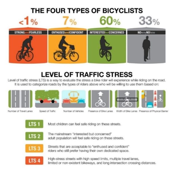
LTS = Level of Traffic Stress. Image credit: RWCMOVES
People need to be kept safe all the way to their destination. Within the Low Traffic Neighbourhoods, there are streets where vehicle traffic volumes and speeds are both so low that it is possible for bikes to mix with cars. But every arterial needs protected cyclelanes, or the majority of people won’t cycle.
The “back-streets” suggestion stems from a resistance to taking space from public transport, freight or general traffic. The argument is counterproductive for those networks, though, because without door-to-door safety for walking and cycling, congestion won’t drop:
- Deliveries would still be by courier van, not cargo bike
- Children wouldn’t be able to cycle themselves, they’d still be driven
- Adults would drive too, as walking or cycling on unsafe roads wouldn’t be attractive.
Back-streets are great places to walk and cycle – if that’s where you’re going. Some complete off-street paths would also be great in addition to the streets. But off-street and backstreet routes are insufficiently connected, direct or intuitive to create a network.
Paradigm Shift
At the beginning of the post, I asked you to imagine reducing traffic considerably, and then tried to paint a picture of how our streets could be if we managed to do so.
But throughout the post, you may have realised that it is through transforming the streetscapes that people can stop driving. By giving space to the space-efficient modes – like walking and cycling – we give people options, reducing car traffic.
We ALSO increase capacity. There are lots of different versions of this diagram, using different values. This is Auckland Transport’s version:

Reducing the number of general traffic lanes allows us to re-establish the missing network of safe cycling. This is critical for our growing city, to increase capacity and give people freedom of movement.
Liveable arterials can be delivered using a tactical approach, moving kerbs and drains as little as possible. A city-wide approach can use economies of scale and be delivered cheaply. The approach makes better use of our infrastructure, lowers our transport costs significantly over time, and delivers better on our existing challenges.
But it does require a major paradigm shift, which focuses on delivering accessibility, liveability and freedom, rather than high vehicle throughput.

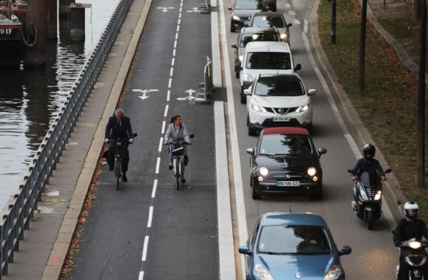
Paris. Image credit: Carlton Reid
Postscript
I named this post after the subject of a presentation to the 9th International Cities, Town Centre and Communities Conference in Sydney in October 2008. The conference programme says:
Liveable Arterials in Auckland City – the Challenge and the Process (p42) Mr Ian Munro, Urbanismplus Ltd & Mr Matthew Rednall, Auckland City Council, Auckland, NEW ZEALAND
Auckland City Councillors were advised the conference was:
an opportunity for Council representatives to gain an increased understanding of best practice in sustainable development, town centre revitalisation and public space redevelopment.
There have been different names for the work since: the Corridor Management Plan, Integrated Corridors, and now Connected Communities.
But thirteen years on, what has been delivered? Who’s in charge? And who’s keeping watch?


 Processing...
Thanks Heidi, great post. I hope we can get there with our streets. It doesn’t seem like it should be that difficult.
Earlier this year, AT add bike trips to their APP, that direct bike users to not use their arterial roads. They know that these roads are not safe, and their solution is for slower moving bike users to travel 50% further to rearch their destinations. Thank you so much for posting this, for years I have thought that Arterial roads are the place that most desperately needs real separated bike infrastructure, because using the arterials means you can actually get places in reasonable amount of time. A shame AT fundamentally opposed to this.
Thanks for that heads up. I don’t have my own phone to check the app but imagine there’s a version I can use on my pc.
Yes AT need to reflect about what Vision Zero means about safe cycling on arterials, because their plans and their actions aren’t always aligned.
The reality is that the app is by a different team and is attempting to provide riders with a ‘safe’ route and unfortunately that means avoiding the most direct route – it’s merely responding to the current environment, but indirectly reflects AT’s view of cycling which is that it’s a leisure activity with no importance.
Yeah, the app’s team lead is on twitter, seems to genuinely care and is trying to make any improvement they can, somewhat independent of AT’s overall policy.
They’re pretty responsive if anyone has any suggestions / bugs etc.
Cool, ta.
Yes they’ve been doing good work keeping the website Journey Planner up to date with all the same functionality of the AT Mobile app, including the bike/walking directions and all the filtering options
https://at.govt.nz/bus-train-ferry/journey-planner/
I love this post – it’s so clear on the huge possibilities, and on how long we’ve been waiting to see a real, living example of a living arterial in our clogged-up city.
With COP26 the focus of the week, stronger 2030 carbon targets, and the government’s draft Emissions Reduction Plan calling for widespread reallocation of significant street space for better bussing/ biking/ walking/ scooting…
…dare we dream of even ONE demonstration project in 2022, as a treat?
“The target is ambitious – so ambitious that from the outset, the Government has acknowledged New Zealand will need to help reduce other countries’ emissions and count those reductions towards our target.”
So we can still have our Levin expressways and massive arterials and all those other things we couldn’t possibly change in the next 10 years.
The money which we are going to have to send overseas would be better spent building electric buses, cycleways and wind turbines in my opinion.
Dont get me started on that levin expressway.
I sent in an OIA because they hadn’t updated the cost on project page from the 800 million it was before. And apart from GA there was 1 other article mentioning the cost increase.
Surprise surprise, week after I sent in my OIA they updated the page to the correct 1.5B and tried to fluff it up with:
Funded through the NZ Upgrade Programme, the new 24 kilometre highway and shared walking and cycling path has an estimated project cost of $1.5b (including contingencies) – costs will continue to be refined.
Ohhh, all is forgiven WK, there’s a shared path.
0.2 BCR for a 1.5B project. And its funded through the NZ upgrade program so wood & labour are effectively doing this all on their own.
Come on.
Heidi if the Preston Road is the one in Otara it does have buses. I would like you to analysis what has being done on Lambie drive and Puhinui road with the link to Puhinui Station and the airport I think its good especially Lambie drive. I expect the intersections wouldn’t pass your scrutiny but I think the layout at the bus stops is good. A lot of work was done I think shifting gutters on Puhinui Road. Can we find out how much it cost. Seems to me it would be a good design to roll out elsewhere. Also I remarked on Fridays post it seems pretty much ready to drop some light rail tracks onto especially from the station to the airport.
Ah yes, so it does Royce. Luckily it doesn’t change what’s possible on the street. I’ll make a change in the text so others don’t have to waste time commenting.
I will take a look at Lambie Drive and Puhinui Rd some time, thanks. It’s an area of town with significant family history for me and I was a bit miffed as the trees they removed didn’t need to go – if they’d used a low traffic neighbourhood plan for the whole area. But it’s cheering to hear you’re impressed with the layout at the bus stops.
In terms of costs, why don’t you identify exactly the piece of work you’d like to know the cost for, and ask? It’d be interesting.
I think it’s important for this site to accumulate a database on what the various upgrade actually cost so I think what I would like to know what the whole project cost that is any work that took place between the Manukau bus station and where the road enters Auckland Airport property. This is important because we seem to have a continually increasing project cost virus circulating. It seems to me that this was a well executed bus and cycle lane installation project on a previously car centric road. Preston Road could be another.Before Te Irirangi drive was built it was the main thoroughfare and bus route between Manukau City and Botany town center. It is a lot calmer but the bus is still required along Preston Road and through the industry to Botany Town centre.
We need to be doing this sort of analysis – then actually rapidly carrying out the changes – in cities and towns across New Zealand to have any hope of the emission reductions we need to do. Thanks Heidi for all the work you do.
I think the narrow footpaths next to 4 lane arterials is a massive problem, I don’t feel safe walking along those by myself let alone with my kids (and it isn’t pleasant either). Proper separated cycle lanes don’t just benefit cyclists, they also significantly benefit pedestrians.
Unless the road is wide enough to safely have 4+ car lanes and cycles and pedestrians, then it shouldn’t have 4+ car lanes. Most of those roads weren’t originally like that, they were made that way by traffic engineers at a time when safety and walkability were not high on the priority list. In my opinion AT have an obligation to correct this, just like any other business would be obligated to fix any obviously unsafe decisions they made 50 years ago.
The work at home thing should become more accepted by corporates. It is good to get out a couple of times a week but the whole concept of making everyone commute every day and all at the same time is absurd.
Maybe we should have rules of maximum numbers of commute days by industry.
I guess significant congestion charging is the “free market” alternative to a rules based approach. In theory work from home businesses would be able to pay less and still attract employees due to the commute cost and time savings.
We could suppress demand in far better ways than some Muldoon esque heavy handed interventionist industry by industry rules.
I am not sure we can. Road pricing tends to shift demand to public transport, which is often more expensive for the public purse. It also has little effect on people with a lot of money and a huge effect on those with little money so it fails the basic concept of maximising utility.
The idea of having a central office and making the wage slaves all turn up at the same time is one of those persistent ideas from the industrial revolution that is hard to shake off.
The other problem with our current setup is that it was established when Dad went to work and Mum stayed home to look after the children. When we moved to both Mum and Dad having paid employment outside the home, we brought in wholesale childcare, for pre-schoolers, before and after school and school holidays. And then we had parents taking time off to look after their children when they get sick. So we doubled peak hour traffic (Mum & Dad on the road) and created even more journeys with the childcare/pre-school/after-school pickups & drop-offs.
What if we’d decided instead to split and separate shorter working days? What if Mum went to work for 5-6 hours in the morning, then came home, had a handover with Dad, who then headed to his work for 5-6 hours in the afternoon and evening? We’d instantly reduce rush hour traffic and, since they’d always be a parent at home with the children, walking or cycling with them to school and other activities would be much more feasible. There would be enormous savings on childcare costs and on the distraction and absence factor caused by people trying to work and parent at the same time.
And I think there would be a lot more support for safe walking and cycling options if people perceived this as something that could actually fit into their everyday lives.
Another random thought – once upon a time, local businesses made local deliveries via teenagers on bicycles after school. We could go back to doing that, if the roads were safe for cycling. Especially now that we have electric bikes.
+1
Heidi, good work again.
After the government’s announcement of a 50% reduction in emissions it will be interesting to see AT’s response. Will they actually start to change anything?
Would a Special General Meeting of the Board be a good start, in open session, so that it is transparent?
I apologise for misleading people that it is a 50% reduction from any meaningful number.
The Prime Minister’s chief science advisor, Dame Juliet Gerrard, admitted to The AM Show there is a “bit of jiggery-pokery” with the numbers.
I’m still chuckling about the misuse of the term “fair share”.
There are also a lot of arterials where they could easily fit some cycle infrastructure with no real “sacrifice” other than roadside parking for residential houses (many of which have their own driveways).
So much low hanging fruit that isn’t being picked because it isn’t in AT’s favourite areas.
East Coast Rd on the Shore is a perfect example. Very wide, already has a flush median, goes past or very near several of the largest schools in the country, and also to several of the busway stations.
It desperately needs both a buslane and (protected) cycle lanes and it doesn’t.
Rosenbank Rd, Avondale. Currently has shoulders on either side of road with no parking allowed for majority. Just put protection in and make it a bike lane.
Rosebank obviously -must be the German Cafe and Bakery on it that made me go Rosen!
Council has had a plan to have cycle routes on main roads for many years. They’re not getting built, probably mostly because the council has run out of money, all while rates have been increasing astronomically (multiples of the inflation rate) and borrowing has increased to the point where the debt rating is in jeopardy. I’d like to know why, and where the money has gone. More importantly, what month and year will the following be finished/started:
Avondale-New Lynn path following the railway line
NW cycleway, Takau St to Nixon Park
Pt Chev & Meola Rds
Gt Nth Rd Waterview – Ash St
The rest of the proposed network
“I’d like to know why, and where the money has gone. ”
Roads.
We haven’t run out of money, council has just refused to fund cycleways and instead have built or widened roads.
This copies badly but is from the 2021 AT Annual Report. So $542 on roads, or about $292 for every man, woman, gender diverse and child
New capital expenditure (figures are: actual, budget, last year)
Roads 342,263 340,744 290,045
Public transport 293,225 341,430 169,243
Other 32,216 15,314 20,883
Total new capital expenditure 667,704 697,488 480,171
Renewal capital expenditure
Roads 184,308 190,982 176,012
Other 10,040 14,682 11,313
Total renewal capital expenditure 194,348 205,664 187,325
TOTAL CAPITAL EXPENDITURE 862,052 903,152 667,49
Probably with virtue-signaling excuses of “providing cycling routes and transit priority”, which end up being a line of paint on the road and a discontinuous bus lane respectively.
They’re not getting built, probably mostly because the council has run out of money
That is not the case in the slightest. Its preserving street parking and traffic lanes that prevents these projects from being built.
Yep. The increase in what is expected of cycle ways is actually convenient for AT, as it makes it easier for them to say, there is no money, when is actual issue is they don’t want to reallocate the space needed.
Jack, AT have to meet their key performance indicator:
Average AM peak period lane productivity across 30 monitored arterial routes
LTP performance measure
27,500 32,951 EXCEEDED
I am not sure though that I was looking at the right version – I couldn’t see an emissions reductions target.
Can you send me a link?
Id be interested how they’re measuring it. If they added bike lanes on some of the top areas of arterials they could very easily end up carrying more people than the car parking / median or turning lane it replaces.
https://at.govt.nz/media/1983812/at-annual-report-2020.pdf
Jack, I’d be fascinated to learn how AT measure most things. I cannot believe how unlikely I am as a PT user. Timeliness overall is above 90% apparently and yet my experience is closer to 70%.
This almost perfectly encapsulates what l conveyed to AT after a bike incident. There is a very good bike way/shared path alongside 20A,starting Hillsborough Rd,technically joining up with North Western path,but access from Hillsborough Rd is difficult if choosing low traffic option (massively steep hill),or dangerous in heavy traffic. It also goes missing a bit ,joining together and you end up on the narrow footpath as discussed.
How much opportunity cost is being wasted here by poor access, the overseas success has shown,this stuff has to be done quickly,you cannot allow it to go over election cycles, it just gets undone.
Yep that bit kills that while shared path. I struggle up there with my e-bike. Looks like there might be some less steep land on the other side of the motorway maybe.
The Great North Road example looks like there is plenty of space to widen footpaths with a small purchase of land from each adjacent property (as is regularly done).
The lanes themselves could be narrowed as could the flush median (or just remove it) to provide room for cycle lanes.
Streetmix is free and really easy to use. You just drag and drop the elements you want. Why don’t you put in the dimensions you’re thinking of and then load up an image so we can discuss?
Are you trying to keep four lanes so two can be for buses? If this is what you’re after, the “small purchase of land” will need to be a strip about 6m wide – unless you’re going to reduce that to, say, 5m and manage bespoke solutions at each pedestrian crossing and bus stop?
“Small purchases of land” are how to feed further traffic increases back into the worsening problem. That’s the cause of the steady road widening programme, which is why our transport emissions have risen so much.
If only it were so simple…. Well, on many arterials (East Coast Road is one), it is that simple. so we’d better get the mandate straight and get on with it.
Unfortunately, for many arterials it’s not that simple.
Medium-density housing is being enabled by government as well as AC, but the consequence for the most desirable locations (next to the PT, active mode and car accessibility of arterials) is more demand for on-street parking and more demand for arterial frontage vehicle crossings. Even if the parking demand can be moved of-street (not easy where development happens next to several existing high-demand lots that don’t have off-street space), then the increase in numbers of vehicle crossings and the order-of-magnitude increase in users of existing crossings makes removal of flush medians and development of safe and attractive footpaths and cyclepaths “almost” impossible.
So, people, what can we do about that “almost” to reduce the numbers of vehicles parking on, and turning on and off arterials mid-block? The “back street solution” can certainly be applied to private cars within (but not across) LTN blocks, but the rules and methods to gain access from the nearest side road are not at all straightforward, where every private lot can develop whenever the owner chooses, and without any responsibility to develop alternative access routes.
If GA can find some answers for this, for MHUD, AC and AT, we might get somewhere.
The easy way to reduce the number of vehicles parking midblock is to ban parking midblock.
Completely agree. If you allow free parking on arterial in th first place, people will make decisions based on the parking being there in perpetuity. Ban it now or charge for it and people will make different decisions.
I’ll write soon about vehicle crossings, because you’re not the only one to have brought them up.
The vehicle crossings and excessive parking come with the lower density urban forms of the last 100 years. Cities with quality medium density to higher density mixed use areas have few vehicle crossings and very little parking.
As we change from low density sprawl to higher density compact urban form, the number of vehicles crossings, and the amount of parking, should be reducing to match.
That’s something Council and AT together should have sorted out 11 years ago. The opposite is happening, due to some systemic failures of both organisations, which I’ll write about at some stage soon.
Egregious lack of parking enforcement is one of the problems, but it’s just one of several.
The medians and mid block driveways are a huge issue.
My question is, why is right turning into driveways treated as some kind of given or right? Why is the acceptable solution not to add a couple more sets of lights along the arterial, at currently unsignalled side streets to enable turning around, and put a curb down the middle. Chucking down u turns wherever on arterials is nuts.
Overall AT seems extremely attached to allowing right turns, where they really shouldn’t: https://goo.gl/maps/rRJKVvAS2DyrdUxd8 for example, this is an insane situation. Granted they’re adding lights here. But its crazy.
I guess the ‘radial’ solution is: Why do we care about these right turn movements? they’re dangerous, and continue to be more and more dangerous. At the cost of some small amount of convenience we could have these movements accommodated other ways to maintain property access with left turn in and out only.
The other factor is, why is it expected that we provide enough parking to meet demand? Demand seems to expand to fill whatever you can throw at it. “Just dont”? is this not an acceptable solution? The side effects can be mitigated, more bollards, actual enforcement, paid residential permits. People will get the message, exactly like downtown apartments are now. People don’t expect to be able to park there, they don’t buy cars.
My armchair speculation is that redevelopment of these sites would ideally come with strings. Some maximum expected vehicles per day crossing the footpath and cycle lane coming from directly on the arterial. So that you’re basically expected to provide maximum, a loading zone or 1 or 2 parks, mainly for services that need to access the building. Unless you can connect to an existing side street.
*I guess the ‘radical’ solution is….”
radical, not radial
The Paris photo is a perfect example! Of why the capacity argument is discredited for cycling and walking (but not PT). It may be technically correct but is not the real world! Not even close! e.g. the NW cycle lane barely gets the quoted hourly rate per week! And that is for 2 lanes! No amount of gold plated feeder lanes would get it to that usage.
The NW cycleway is also a great example of in the scheme of things a pretty poor cycle facility. It provides little access to businesses, and the housing access is also poor.
With the kinds of maximum capacities available from cycling, quoted in the article, you can and should put bike lanes front and center, in high value space. Ie, down broadway through newmarket, and along manukau road. Where they will have maximum use. We can do the things that car infrastructure cant do, provide doorstep parking for everyone, right next to the busiest infrastructure.
These lanes also don’t have to perform at the quoted rates, they have to eventually perform at a higher rate than what they replace per m width. Ie, so long as they do better than 1/2 a car lane, ie ~800? per hour per bike lane over rush hour, then that’s a win.
You also ideally don’t want to achieve these maximum rates on cycleways, just like for cars that represents a degradation of service. The fact they don’t fill up is a win and an argument for more rollout. Its one of the key advantages, we could accommodate huge growth in trips with the little change to infra. Where is the trip growth going to be accommodated with car infra on our arterials? it simply cant.
The capacity argument isn’t discredited, you may have misunderstood?
Car-brain: thinking that an active mode corridor has to be jammed up with high volumes of pedestrians or cyclists to be “worthwhile”.
Bike brain: thinking a bike can get remotely close to the versatility of a car.
Car brain: thinking reallocating 20% of a roads space to bikes is an express statement that bikes are car replacements for every trip.
20%? Ha! Heidi wants to take 100% road space away from cars.
1) Heidi doesn’t represent everyone’s thoughts on Greater Auckland
2) Even in the most bike heavy example in the article above, its about 24% of the roads width.
The numbers for the car lanes are more dubious, actually. They’re more for motorway lanes. For arterial streets it’s more like 700 – 900. You can have a look at the NACTO values here: https://globaldesigningcities.org/publication/global-street-design-guide/defining-streets/multimodal-streets-serve-people/
Your premise is discussed later in the David McCraw thread:
“Simply, the debate needs to move away from a “who is using it right now” basis to “what’s the minimum it has to be like to achieve target modal share”. Then we can argue about the target modal share, much easier than arguing about why people do or don’t use partial infra today.”
And the facts are clear about Paris. Making a comment about that one serene picture must mean you haven’t been looking at all the amazing videos and data about Paris’s cycling uptake? Really?
Paris is remaking itself as a cycling city, and a big reason is because it has a leader who can see past petty resistance to change. But it is also a city that has planned properly for 30 years, with a Sustainable Urban Mobility Plan. This means it’s reduced its vkt by 44% over the same time span (2002 – 2019) that Auckland increased its vkt by about 42%. It also means the plans were in place and able to be sped up when Covid hit. Whereas AT has floundered.
The difference in our vkt trajectories wasn’t urban form or public transport – which had **already** shaped the modeshare of the two cities. We were in fact set up to find it easier to reduce vkt; our car dependent system means we had the low hanging modeshift fruit, not Paris. This was about two cities heading in different directions due to different planning and investment.
Thanks for those numbers Heidi, its extremely hard to get a good answer out of google as to the capacity on surface streets per lane.
Seems like there are a lot of variables though
You do have to remember that Paris should be perfect for cycling. What most people know as Paris has a very good metro system, regional rail and of course long distance rail. Having lived there I can tell you that you don’t need a car in Paris! The only exception is for the annual strikes 🙂
Auckland is not Paris and never will be! Agree that this is in part due to past planning with poor PT, but also due to its compact size, radial layout and of course population. The central part of Paris is just 7km in radius. i.e. CBT to Pt Chev.
You’re not accounting for the fact that Auckland will be undergoing significant urban regeneration with the NPS-UD, which mandates Mixed Housing Urban zoning at minimum across the whole urban area, and expressly encourages 6+ storey development within 800m of frequent or rapid transit.
Auckland isn’t Paris, sure, but it should become more like Paris, with density creating compact neighbourhoods that can be easily navigated on foot or by bike. Imagine the whole Isthmus built up to a comparable density as Paris or Amsterdam.
It is quite the contrary, the lower density of Auckland makes cycling much more important. In Paris you can often walk to things, while in Auckland you almost certainly need at least a bicycle.
Re: back street fantasy
I lived and biked in London and preferred back streets and paths. Made minimal impact on distance but massive impact on enjoyment. I didn’t actively make this decision but made a serious of tweaks to my trip over time which I take as instinctual.
I think if you looked at actual journeys rather then indicative lines I don’t think the journey times would be significantly different.
With arterials in Auckland I think it might be a bit different. The 2018 proposed “backstreet” cycleways next to Dominion Rd are quite far from the main street (a few hundred metres east and west approx.), and were rejected by cycling advocates.
https://www.bikeauckland.org.nz/straight-talk-dominion-road-bike-routes-light-rail/
You’re right that people will find their preferred route over time, and these preferred routes may incorporate backstreets.
But we need to design for people before the trip has become habitual. Newcomers deserve safety. The first time someone – of any age – goes somewhere, they need to be safe, not just later when they have worked out a backstreets route.
Good networks are intuitively navigable because a lot of trips people make are to places for one off or occasional visits rather than the daily routine.
I guess people are looking at the most direct route (very practical engineering mindset).
I look at it from a social/psychology perspective. People like biking on quiet streets not busy roads with alot of traffic (pedestrian, rail or otherwise). You can mitigate with safety features, seperation, etc but its still a busy noisy polluted road.
Safety is also not even comparable. You can put in the best system on Dominion Road but you will have exponential opportunities to do something stupid and unpredictable which no safety system can eliminate.
The “every mode of transport arterial” is really difficult and leads to comprimised solution for every user. Or in AT’s case a good way to make it too hard to get a project off the ground.
The route shared by Matt looks like it was set using only public land. I’m sure with minimal PWA aqusitions (side yards are typically 3m so plenty of room to punch a direct route).
Meanwhile Christchurch is building 100km of cycleways….
Looking from an Auckland perspective:
• many shopping areas sit on arterials and are hard to reach unless you can ride on these arterials. And since you mention psychology, what do you think the most obvious and easy to follow routes are?
• many areas in Auckland are hilly, and are pretty much impassable on a bicycle unless you can follow arterials. (it is part of why those arterials are where they are in the first place)
I agree, Roeland. Optimistic, in terms of your conclusions that on arterials “safety is also not even comparable” and “it’s still a busy noisy polluted road” which cities that have done road reallocation on arterials well have you been considering?
You’ve illustrated my point about “resistance to taking space from public transport, freight or general traffic” when you said “The “every mode of transport arterial” is really difficult and leads to comprimised solution for every user”… I’m not sure which part of how I addressed the issue you’re refuting though.
So please forgive me for pressing the point, and let’s remember just how substandard our transport planning has been. We have not just “compromised” the cycling network, we have annihilated it, and for equity and health that needs to be set right.
If we had simply had a reasonable SUMP 20 or 30 years ago, our traffic volumes would already be lower than the most ambitious of all the government’s transport climate plans. Changes on the arterials honestly don’t need to be lose-lose or lose-win, they really can be win-win-win-win. All modes, climate, health and society can all be improved.
What it requires is “major paradigm shift, which focuses on delivering accessibility, liveability and freedom, rather than high vehicle throughput” and radically reduced traffic volumes. Sure it requires change, but it’s all good change.
It’s a complicated issue with no perfect solution made harder by Auckland’s sprawl and love of cars. I’m not aware of good examples that could be used as models for here (especially for arterials and our codes of practice). Cyclists do deserve good infrastructure and I’m not a fan of sharing the busiest roads. I’d rather they have their own arterial then share.
Perhaps a new twist on London early strategy; dedicate entire car lanes(unprotected), wider footpaths for unconfident users, target 30km/h areas, close through roads, provide good last mile solutions with plenty of bike parks at bus stops and the ability to take bikes on buses. Not as sexy as a big road redo but more cost effective and easier to roll out politically. I see bikes supporting PT and less demand along arterials.
Thanks Optimistic, you’ve got some good suggestions there. Taking the discussion further:
– dedicate entire car lanes(unprotected) – might as well give them protection. We have the money if we reallocate it.
– wider footpaths for unconfident users – Accessible Streets has been held up on the issue of cycling on footpaths. There’s currently a legal challenge. I say don’t go there as policy.
– target 30km/h areas – yes. Follow VZ and Stockhold Declaration
– close through roads – yes.
– provide good last mile solutions with plenty of bike parks at bus stops – yes. For deliveries too. In fact I’ll write about this soon. LOTS happening overseas.
– the ability to take bikes on buses – Maybe. Lots of PT people have good reasons why not.
– I see bikes supporting PT – yes.
– Less demand along arterials – no, it’ll simply grow. We have a lot of growing to do.
It is complicated but mainly in how we tackle the political economy of car dependence.
Some places where you might be getting stuck are:
– a belief that Auckland’s sprawl makes things harder to change. No, it makes our current stats bad, but it opens up huge possibilities – if you follow the current emissions reductions research you’ll see that our form is a perfect fit for adopting some emissions reductions recommendations harnessing the strength of e-bikes and e-cargo bikes but it requires proper road reallocation. We have MORE opportunity there than many cities that already have some sustainable networks in place.
– a belief that Auckland’s “love of cars” makes things harder to change. In fact, the way Aucklanders respond to elections and consultations shows that we want investment in the alternatives because we’re sick of the lack of choice.
– it’s good to use what you have personally experienced but it’s important to also temper it with what the evidence shows. In this case, NZ is suffering from people who can’t imagine “sharing the busiest roads” when reallocating lanes on busy roads to cycling is shown the world over to be effective not just in creating safe space but in reducing the need to drive and thus vkt and emissions. It’s how you reduce traffic in nearby streets as well.
Another city converted to cycling: Seville
https://www.stuff.co.nz/environment/climate-news/126738481/reimagining-wellington-how-the-city-of-seville-became-a-cyclists-dream
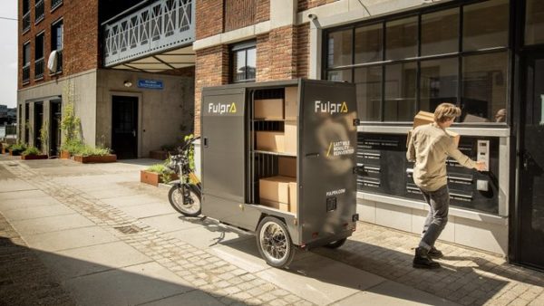
Those Fulpra cargo e-bikes with the high-sided bodies look great in promotional photos taken on a fine day, but I wouldn’t rate their chances of staying upright on a typical windy day in Wellington.
That’s odd. What happened to Mary Hamilton’s rather scathing comment which appeared around 2a.m and has now disappeared, after I replied to it??
Moderators delete overly negative, belligerent, ranting, or unsavory comments.
Mostly pro car / anti PT comments seem to get left up, but if they’re not talking about things in a productive way. Ie with some actual points, then they get deleted.
Personally I wouldn’t mind some of the deleted things to be left up. Tangling with Hosking listeners that crawl out of the woodwork is kind of fun. Plus I think part of the goal is to try convince as many people as possible with the cold hard truth that PT / density / urbanism is the way forward for our cities. Just deleting all of their comments doesn’t give them the change to change their minds. And doesn’t give us the chance to read and disprove common counter points.
I have no idea about the comment you were replying to though. It may have just been nasty or abusive and would have been poor form to leave it up.