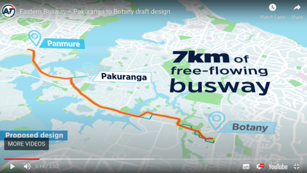
People who work in and visit the East Tamaki Commercial and Industrial Area will soon be able to choose from a vastly better offering of travel options. The first project on the books – all the way to Botany – is the Eastern Busway.
And hopefully the Airport to Botany project along Te Irirangi Drive will get going soon, too.
![]()
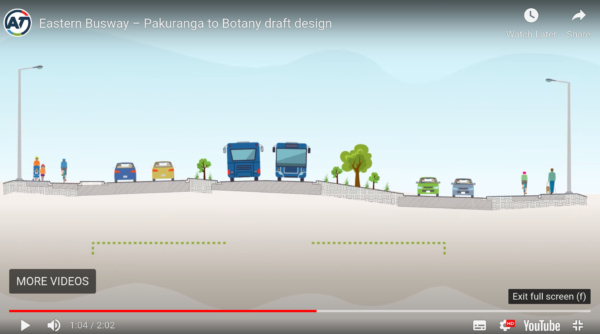
Both projects will include rapid transit and safe, separated cycleways.
At present the area is, of course, extremely car dependent. This can be seen on Timothy Duhamel’s excellent maps of the 2018 Census data, Flowmap.blue. There were apparently only 60 people who “typically” took public transport to work in East Tamaki in 2018:
Public transport journeys to work for East Tamaki, 2018 Census data. Flowmap.blue
The census showed that using bikes wasn’t a “typical” way for people to get to work in East Tamaki. Clearly, the “easiest choice” for reaching East Tamaki is driving. Over 20,000 people said they typically drove to an East Tamaki workplace:

Journeys to work by car for East Tamaki, 2018 Census data. Flowmap.blue
Which is about the same number as drove to work in Penrose, or to the airport precinct. If we could reduce driving to these three areas, it would go a long way to reducing emissions.

Journeys to work by car for Auckland, 2018 Census data. Flowmap.blue
The Eastern Busway and the Airport to Botany route could contribute significantly to mode shift. This means we can expect to see people walking from the busway and cycling from the cycleway to factories, warehouses, showrooms, workshops, outlet shops, and to the supporting services like lunch bars.
But this is an industrial area, with many big trucks.
What can we do to make this change welcomed for truck drivers, so they feel their stress levels lower rather than rise? What can we do to keep people on foot and bike safe? Resolving the conflicts now with good street improvement plans would help maximise the mode shift from driving to sustainable transport, ensuring we get the highest possible return from the rapid transit investments.
This is important because Auckland needs to largely decarbonise its transport by 2030. Parts of town receiving investment in their transport systems need to respond with substantial mode shift, as there are many parts of town that won’t see that investment, and will have less ability to respond.
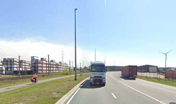
I’m not sure if there’s anywhere in the world that designs active travel in industrial areas really well yet, but some cities are clearly taking steps forward. In Rotterdam, for example, areas near the port have been developed over the last decade to cater better for people biking and walking.
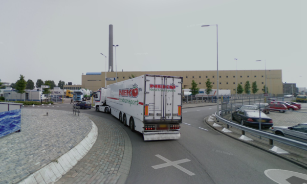
The roundabout above was improved with green infrastructure and cycleways in about 2014::
In this post I’ll use the East Tamaki industrial area to explore:
- Planning ideas to improve conditions for walking and cycling
- The benefits
- The public discussion required
- Funding
Planning ideas
Sized for trucks: Planning changes in industrial areas differs from other areas because there are more trucks:
- Some street dimensions needs to be larger, including widths and turning radii, and
- Stopping areas on the main streets for trucks are useful, as truck drivers don’t want to turn into a driveway unless it’s clear, and they’re sure it’s the right one.
General improvements: All streets in East Tamaki need
- Well-designed kerb buildouts to reduce crossing distances for pedestrians, with proper pedestrian crossings, at frequent spacing
- Safer driveway entrances. Where possible, they should be narrowed, and modern technological advances using lights and rising bollards could be useful
- Cyclelanes, protected by a generous buffer to accommodate the turning bodies of trucks
- Intersections redesigned to improve pedestrian and cyclist safety
- Marked loading or stopping bays. Bookable if competition arises
- Competent parking enforcement, including consistent messaging so drivers are clear

Traffic circulation: Creating a stronger street hierarchy, such as the low traffic neighbourhood approach, allows different streets to perform different functions:
- Local streets are quiet and provide access to properties, with low traffic volumes and speeds
- Main arterial streets take higher traffic volumes
- Through-traffic stays on the main arterials
- Walking and cycling is safe and direct on all streets, becoming the easiest way to travel short distances.
Space for cycle lanes: A key question is where to take the space for cyclelanes from, given trucks are large and need space to manoeuvre. Ideally loading zones will still be available on the street, so repurposing kerbside parking isn’t so easy.
One possible solution is to make the local (non-arterial) streets one way. This frees up a whole traffic lane, allows properties to be accessed, and retains space for moving and parking trucks:
This street could be made one way
Here’s one layout to consider. If the concept is used, the final design would need more local knowledge:
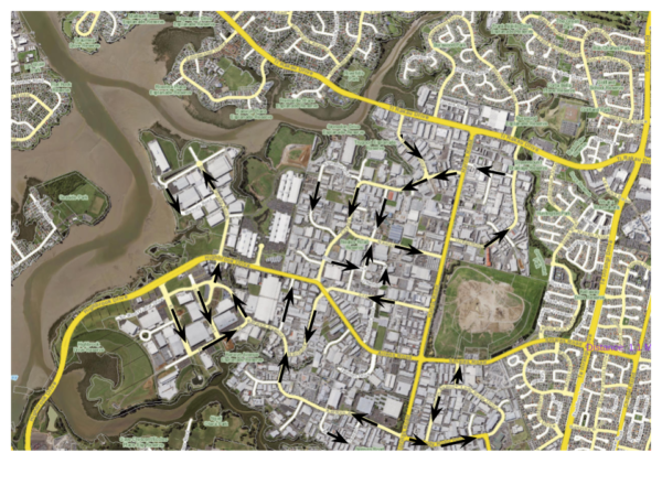
I’m imagining two types of streets would remain two-way:
- The arterial streets – in darker yellow above – eg Highbrook Drive
- Some of the local streets where a one way loop is impossible, like cul-de-sacs:
Providing space for the cycle lanes on these streets would involve either:
- Widening the paved paths in the grassy berms to include cyclelanes.
- Reallocating kerbside space into protected cyclelanes.
Widths seem generous enough that one or other of these solutions should be possible in most places.
Benefits
The benefits of investing in safer walking and cycling facilities are well-documented. Let’s look specifically at who’ll benefit from improving the East Tamaki industrial area.
Workers and their families
People in the area already walk, even if it’s just to get their lunch or find a spot in the shade to eat it.
But they should be able to reap the same benefits of switching away from driving to work that people who work in the city centre have already discovered.
These benefits include being able to reduce household expenditure on transport. Sometimes people can sell a car, which reduces parking requirements at home and gives them more choice about where to live.
Biking is particularly cost-effective, and e-bikes have really increased the distances people are able to cycle. More and more people have recognised that e-bikes are cheaper than cars to buy, store, operate and maintain. So although the upfront cost of an e-bike can seem expensive for people who have always thought of bikes as recreational, in fact they can be excellent for the household budget.
Some people haven’t been able to consider working in East Tamaki because they can’t drive or don’t have access to a car. More choice in jobs for these people is a considerable benefit.
Families also benefit. Sometimes the shift from driving to work every day doesn’t enable households to sell a car but it does mean other family members have access to a car when previously they were stuck in transport poverty. This can be good for taking up work and educational opportunities, and for relationship health. And they benefit, too, from having a healthier working family member – fitter from cycling, more relaxed from using public transport, and healthier from the walk at each end of the journey. This makes for a happier family, and lowers the health care burden as well as reducing the number of illnesses the family member takes home.
And there’ll be plenty of people working in East Tamaki who’ll still need to drive. They, too, will benefit if others shift to sustainable travel, with less competition for parking and less traffic on the roads.
Cycling in an industrial area of Antwerp, Belgium
Visitors and customers
Visitors include customers, couriers, suppliers, service providers of all kinds, family members coming to after-work social functions, or carpooling buddies meeting after work.
Some of these people would make good use of improved walking and cycling facilities and of the busway, giving them options for sustainable travel.
There are already logistics and courier companies located in East Tamaki. With safe cycling infrastructure they’re likely to start using e-cargo bikes to deliver to local companies.
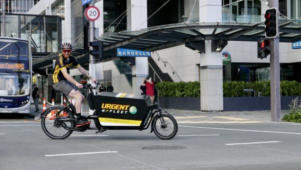
Image credit: Urgent Couriers
Truck drivers
The benefits to truck drivers include:
- Lower traffic volumes, due to the mode shift, meaning less congestion and less parking demand
- Lower stress as there’s infrastructure to separate the different road users, keeping everyone safe.
The traffic circulation pattern would only add on a few hundred metres to a truck’s journey. As long as it is intuitive, the changes would be insignificant compared to the benefits of easier driving.
Business managers
Transit and improved active travel facilities have been found to benefit businesses in a number of ways. Walking from the transit stop to the workplace, or cycling to work, provides regular exercise that can increase health and fitness substantially, leading to improved concentration, stress management, job satisfaction and attendance. Absenteeism due to car failure and maintenance can also be reduced.
Business managers also benefit from being able to choose from a larger pool of potential workers, as there’s more demand for jobs in areas that are easier or cheaper to travel to.
Property owners
Some workplaces in East Tamaki use a lot of land for carparking.
Some of this land could be developed, providing more revenue for property owners. Or pockets could be converted to courtyard gardens, making the properties more attractive to tenants.
You can fit a lot of bikes into a carpark.
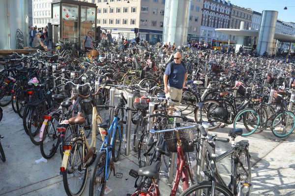
Bikes in Denmark. Image credit: The Arkansas Democrat-Gazette
Local services
Once people can walk and cycle freely in an area, they are far more willing to walk to the local lunch bar – or stationery shop, or work safe supplies store. This provides local custom for local services, and should help the area become more mixed-use, providing the services people need.
Wider Society and the Economy
The public health and environmental benefits of having more people using sustainable transport are well understood. Most people also understand the reduction in traffic danger and congestion if people switch from driving, too.
What’s less well known is that investing in cycling has an excellent return on investment:
https://twitter.com/copenhenken/status/1487714552791945217?s=12
Public Discussion
Safety should be a bottom line; something that is neither queried nor resisted. Yet I’m under no illusions here. The political economy of car dependence means some people are primed to ridicule change before they’ve tried to imagine what it could deliver.
Aucklanders deserve to have the best shot at a good climate response, and we deserve to get the best return from the investment in the Eastern Busway and other rapid transit projects, so we should encourage a proper discussion.
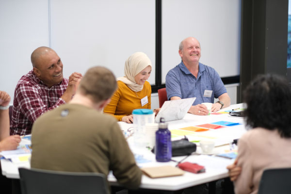
Participants in the Manukau deliberative democracy workshop for Watercare. Image courtesy of Watercare.
I think this is a great project for using deliberative democracy. The process would involve inviting a representative group of people – who work, visit, manage businesses and own property in East Tamaki – to discuss street improvement options, in an unthreatening and informed way. If chosen in proportion to the area’s demographics, this would give a far better idea of what people really think than a traditional opt-in submission process. It would also help Council to hone the material for a wider engagement process, in order to properly answer any queries or concerns that people might have.
If people don’t want safe and healthy travel options, then Auckland Transport would learn from this process not to focus on this industrial area, and to put their efforts elsewhere.
Funding
Funding changes with such a good return on investment is really a matter of the government finding the right way to evaluate investments and matching the right budget with the project. The main street reallocation costs of what I’ve suggested wouldn’t be too expensive, but some of the intersection changes and the technology to keep people safe passing driveways might add up.
But there is an obvious way to source the funding for these improvements now.
The Eastern Busway itself could easily be scaled back, with less property purchase, less construction, and much more mode shift. Spending less on widening the corridor, and more on the areas the project serves, including the industrial area, would improve outcomes and optimise the return.
Even in areas conventionally considered too car dependent to improve, there would be enormous gains.

 Processing...
Also worth noting that we’ve proposed a new frequent route to service this area in the mayor’s climate package too: 37: Manuwera/Homia > Puhinui > East Tamaki Industrial
(https://www.greaterauckland.org.nz/wp-content/uploads/2021/12/Auckland-Council-Budget-CATR-network-map.pdf)
Where are Manuwera and Homia?
typos, Manurewa and Homai sorry!
homia is where you hang your hat. Hey imagine if we spent 14.6B on pt and cycling projects in akl- quickly to build the network like this. not glory lrt way in the future, to be canned by next national govt. what about a bridge next to harbour bridge for pt and w&C-1.5 billion only. love yo work Heids
Thanks for that, Stan. Great.
Matching the right budget with the project should be easy, start with AT renewals. During the various lockdowns Mt Eden Road including through the centre, New North Road through Kingsland, and long stretches of Dominion Road have all been renewed. These are mostly five lanes, with the median, smooth like a billiard table. Footpaths however are mostly untouched, and left to further deterioration.
For example, to the left is Kingsland but note the width of the footpath in front of the tree and the seven (smooth as silk lanes) as you pan around.
https://maps.app.goo.gl/kSNmXPkGscotuUpG6
Then the line markings go back exactly the same, with zero vision of Vision Zero when reinstating them after the surface is renewed. We know lines aren’t best practice safe cycle infrastructure, but considering line locations would have been a good use of everybody’s time through this renewal process to see if anything more than cycleboxes might be appropriate.
That’s the budget you’d want to use. Then if you just at the same time add some kerb realignments where needed using the $billions that seem to be slushing around for PT improvements in Auckland these days.
As every trip starts and stops as a pedestrian trip this should be easy; piggie backing kerb and white/yellow line changes in our town, local, and other centres off the road renewals budget would be a good start. It would also have an amazing BCR, if that’s important to you.
Yes, I agree about renewals being useful for this. In fact, I thought this thread was interesting, which started with the question:
“From Dutch planning circles, how do you split out the budget for cycling? Is it better to have a cycling pot that covers other modes or to have a general pot a cycling element? Or should cycling pots purely cover all cycling infrastructure requirements?”
and answered by a cycling consultant from Royal HaskoningDHV, with this as the final comment:
“When I develop (regional) cycling projects I like to go shopping. A bit of car money here, a bit of cycling money there, some local, some regional, a bit of traffic safety funds, maybe a pinch of public health. Al in the cycling shopping cart and we can build a new project.”
https://twitter.com/Sjoess/status/1486048974989529088
So it’s irritating that WK don’t allow several Activities to contribute to a single project. What’s so difficult?
Good subject Heidi. I worked in the area for many years prior to retiring. The 31 bus provides cross town access from Mangere Papatoetoe and Otara. But you wouldn’t want to take your bike on that route. My trip involved two buses and a 400 metre walk one end and an 800 metre walk the other. Many workers mainly men have jobs that are physically tough the last thing you need is a bike or walk. Woman do office work sitting next to the heater or air conditioning and moaning when the factory workers in the heat and the cold don’t fill out the paperwork properly could do with some exercise. Haha just joking I think. But anyway its not an impossible task and never suggest pacific people are lazy just look who are standing at the bus stop at 6.30 in the morning. Better street layout could make the area less stressful. Workers love set hours so there is a bit of a rush at 4.30 pm. Better bus routes is probably the best answer or maybe AT electric shuttle vans doing last mile from a random bus stop half way down the major arterials. I have one bus stop on Harris Road in mind which would be particularly useful for customers arriving on the 31 bus.
Thanks, Royce. I won’t so much as rise to the bait about the assumptions about cycling, gender, and physical jobs, as give you something more to mull on. My first day on a construction site (in Cavendish Drive) as a teenager, they had me on the kanga hammer most of the day and when I hopped in the car, my arms and hands were shaking so much I was unable to drive home. I got stronger. It was lucky I was transferred soon after to a site in town I could bus to. The following summer, I had to take two buses to get to a 7 am start at a site in Mt Smart, I would’ve been far better off cycling, timewise – but it didn’t feel safe.
There are people in all sorts of jobs – including physical ones – who want to cycle. This is a great presentation to the Planning Committee from Terangi Parima from the Otara Bike Burb you might want to watch: https://www.youtube.com/watch?v=hzXQL5eHgY4&t=1906s
“Here in Otara… If you need to get to work but you don’t have transport -considering all the expenses that has as well… whether that means biking 10 km or more… You’ve got to get from A to B – If you don’t have a car, how are you going to do it? The cheapest option is to bike… the infrastructure doesn’t match up.”
One thing you’ve touched on here is making sure the timing of public transport matches the needs of customers. It’s incredibly difficult to arrive at any workplace before 7am in Auckland. With an industrial area like this, a huge number of employees will need to be there before the 7am shift and if they are running two shifts, the second one finishes shortly before midnight. These hours can make cycling less appealing (cold, dark, and unsafe!) but a well-considered bus service would be so helpful.
*arrive before 7am if you are catching public transport, I mean
Biking from Otara is feasible as there are off road paths through much of the suburb. If anyone needs an experienced person on a kango hammer we know where to look.
Ah the ever so uneconomic EV shuttle. Imagine if AT replicated that 200-300 times all over Auckland at $1m operating costs a time. AT would never be able to afford an extra km of bike lane or affordable PT fares.
Better East Tamaki than Devonport and better than the industrial area diesel bus shuttles that run nearly empty at present. Also a shuttle from botany Town centre is hopeless if you are coming across town. That’s why I suggested it should run from a point along the arterial. The new bus network is good for many things however in this case there is a better way too do it. In any case unless you are prepared to suggest something different then you shouldn’t leap on to your keyboard with negative unthinking crap. We all know the GA position onn the Devonport trial but maybe this is different. And as mentioned by Heidi we are talking about an area that is the extreme case of car dependency caused mostly by its layout with people arriving from multiple routes unlike devenport which is more compact and has only two ways in and out.
I think with over 20,000 people driving to the area each day, and the scale of modeshift required to meet our targets, that there should be ample ridership for good buses through here. Feeders, perhaps, to the busways.
Also, there should be a bit more design for the people driving to East Tamaki from the North and North East. It’s basically a case of needing “crosstown” routes, where the services stop at the busway stations to transfer passengers, but then continue on the other side. I imagine.
Yes Heidi. With annual ridership of over 300 million there should be buses everywhere with great frequency. And at that amount of ridership Auckland will have only started to approach where it has to be.
Excellent post Heidi. I previously worked out in East Tamaki (Allens Rd) and due to poor options resorted to catching the train to Newmarket and then Ubering to my office. Getting home was a bit better but still involved a significant walk, bus to Otahuhu station, transfer to Western line at Newmarket – quite soul-destroying to say the least! It was a blessed relief to be able to finish up with that role at the start of the pandemic, I wouldn’t go back if that travel plan was still what I had to do.
Thanks for the shout-out on the maps, Heidi. Always nice to see work shared! The credit is due to the tool creator and StatsNZ for providing excellent open data.
Werner Pretorius also used the Flowmap.blue tool to produce interactive commuter maps. The key point of difference being that map combines Travel-to-Work and Travel-to-Education counts.
Werner published his work with a full explanatory blog post here on GA, recommended reading for anyone using the data/maps: https://www.greaterauckland.org.nz/2020/08/11/2018-census-commuting-data/
+1
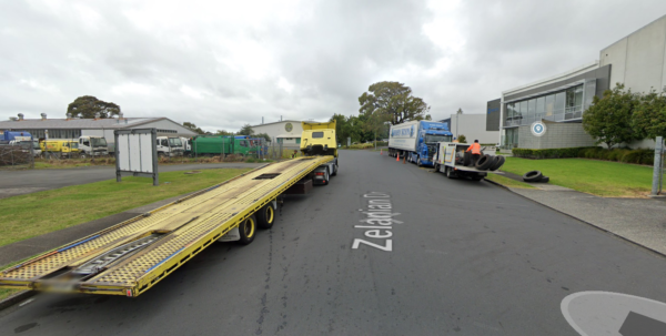
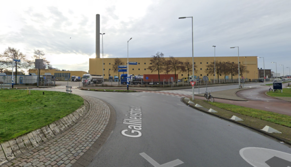
Zelanian Drive is not the best example to show for a truck traffic jam – those trucks are there for servicing at Truck City, a major truck servicer.
I wasn’t showing it to illustrate a truck traffic jam. 🙂 I just showed it to show some trucks. Trucks need servicing; but the point is that to get to the workshop, they are driven through these local streets, using turning movements etc… and the drivers have to concentrate on keeping people on foot and bike safe on streets that aren’t designed to make that easy for them.
Good article, Heidi. Industrial Auckland is often neglected in debates about urbanism and transport, but this is where much of the heavy lifting needs to happen.
You quoted 60 people commute by bus and 20,000 but now how many by bicycle. guess it’s similar to the bus commuters.
Having commuted by bicycle into East Tamaki / Penrose / Onehunga for the last 10 years I would describe it as challenging. Sometimes you settle for a route that is twice as long as you take by car just to avoid the worst black spots. Often these involve riding on footpaths and car parks and over kerbs. There’s broken glass and bits of metal everywhere, especially on the “cycle paths” that are hardly ever swept. So you get punctures, which is not fun. Sometimes you just want to get home quickly so you go the short way, and ride hard. That’s not always fun either, especially after dark.
I think the starting point is intent. In general there is so much space in the main road corridors in these areas that safe cycling infrastructure could easily be fitted in. But it seems never to have been considered. From what I can see, to date there has been literally no investment at all.
Actually it’s worse than that, investments have been made in cycling and walking
but all they’ve achieved is to totally waste the budget on negative outcomes.
Say you want to ride from Otahuhu to Highbrook Crossing – nice and flat and not too bad in theory (if you go exploring – there’s no sign posts), and perfectly do-able especially with an e-bike. Except some dickhead decided when you get to Highbrook Drive you have to choose between riding on the carriageway, the footpath, or this stupid gravel path (that no one ever uses) https://goo.gl/maps/s1Qd1S7KQ6HbgZuj8
WTAF, I still think to myself whenever I see that.
Or you get to a road like Kerwyn Ave which has been designed and built in a way that is the very definition of a missed opportunity. Why no cycle lanes? Why such a narrow footpath? All that grass to maintain must cost a fortune. https://goo.gl/maps/7iyAuypd7iVWUcEe7
Meanwhile as East Tamaki expands, we’re building more of the same. Dumb and dumber. We really are totally fucked.
Thanks. Yes.
I think at some stage we’re going to have to get the people who made decisions up before a jury. Deciding to build that bridge at Highbrook Drive so recently, for example, without a cycle lane. What fascinates me is the weir next to it. From what I can find, it’s no longer used – because the power station is shut. Is that correct? Given this history: https://issuu.com/dustyn/docs/otara_final I hope the removal of the weir has been discussed properly with Maori.
One option that could be discussed is using it as the foundation for an elevated bike path.
I had to cut out the bike map to keep the post short enough. It showed **no** bike commuters to East Tamaki. Which is interesting, given I know a few myself. Clearly having to answer what you “typically” do means people who cycle once or twice a week weren’t picked up. (Such a bad question.) And it’ll be rounded down to zero from a couple of people. Still, it’s very low.
Yes this is probably it. The web page mentions this, it doesn’t show amounts under 6 to protect privacy.
The Census itself reports quanta of 3 people, and cycling in Auckland is low enough to visualise this directly:
https://observablehq.com/@roelandschoukens/the-cycling-dot-map
tl;dr: cycling mode share in this part of Auckland is so low (under 0.5 %) that even a large scale survey like the Census can barely detect it.
A really good post. Transport planning for business park areas does need a re-boot (emphasis on boot). A question – since footpaths in these areas are mainly used by employees getting to work (or getting from kerbside parking into buildings!), would shared paths be viable that we wouldn’t consider for residential or town centre streets?
East Tamaki has a bit of time for planning, once A2B and Eastern Busway are firmed up and connections can be planned. Extent of one-way circulation looks worth exploring. A Business Improvement Area might be a mechanism for co-ordinated planning, rather than the piecemeal RMA process site by site that is going on now.
Car commute reduction would pay back handsomely on Ti Rakau Drive, where intersections are highly congested and block freight movement.
And there are other areas that could benefit from this approach to travel to work.
This is the kind of location where a shared path is probably fine. The Dutch photo in my post below shows a shared path in an industrial area (it is signed for cycling but people are free to walk on it if they like).
Here’s another Dutch example of a shared path that serves the Port of Rotterdam: https://www.google.com/maps/@51.9261724,4.0380428,3a,75y,272.94h,80.01t/data=!3m7!1e1!3m5!1sbj4I538vLukfsCOXdKggzg!2e0!6shttps:%2F%2Fstreetviewpixels-pa.googleapis.com%2Fv1%2Fthumbnail%3Fpanoid%3Dbj4I538vLukfsCOXdKggzg%26cb_client%3Dmaps_sv.tactile.gps%26w%3D203%26h%3D100%26yaw%3D170.62231%26pitch%3D0%26thumbfov%3D100!7i13312!8i6656!5m1!1e4
I wondered the same about shared paths. The answer comes down to the level of ambition, I think. They would provide some safety, raise some concerns, and contribute far less to a mode shift transformation.
I wondered about their place in a transitional phase, but that then brings in further problems: What lengths would advocates have to go to to get them upgraded to proper separated paths, given the rest of the city needs cycling too? Isn’t that just a waste of advocacy effort that’s better directed elsewhere? When would it happen? And – what would the gains really be from doing shared paths initially and changing them later? If they prevent having to make a change to the traffic circulation pattern, is it not better to do that earlier rather than later, anyway? If green infrastructure needs changing, it is better if that happens earlier, too, so that the trees can start growing. If it’s that shared paths can replace footpaths but proper cycle lanes need carriageway space reallocated, isn’t it better to do that now – in order for that to contribute to vkt reduction now?
There’s the media beat up side to this, of course. The big fear of putting something in that talkback will claim is underutilised (while ignoring car infrastructure and investment that sits idle much of the time). But I think the way around that problem is to design and communicate each project well, and build the public’s support and trust. If the media’s going to be a pain, they’ll be a pain whatever AT do. They’d still beat up shared paths, and of course having the ammunition about why they’re bad infrastructure would just put AT staff into positions of having to defend choices they know aren’t best practice. Not ideal. And it’s the sort of thing that works to drive a stake between walking and cycling advocates.
So on balance, I think it’s better to do it well than to use a pattern that we know is flawed. In doing a permanent project that we have time to think through, we should be able to at least follow the international guidelines for rapid Covid responses!! https://www.wri.org/research/safe-bicycle-lane-design-principles
The short answer is that shared paths can be fine if:
– they are designed to the necessary engineering standards of a dedicated cycleway (no cycleway-on-the-footway please!)
– levels of foot traffic are low
They’re far better than cycling in the road but they need to be designed and maintained properly. Junctions can also be a source of conflict. It’s better to have separate provision. Do it once and do it properly.
Some other considerations: PT users will be coming by bus to the area, not train, so they can’t bring bikes and would potentially respond well to e-scooter share at the busway stations. And then there’s the e-cargo bike couriers. So the mix of users of these paths will include more than people on foot and bike. There’ll be heavy cargo bikes and potentially high speed scooters – none of which is compatible with walking.
Great article. Highbrook has appalling traffic during the morning and evening peaks. I personally know people who work in the area and have sought (and obtained) a motorcycle licence at considerable expense, simply because the traffic is so reliably awful.
Highbrook’s low densities and level topography make it ideal for cycling. While the mode share is low, people do cycle to work in the area, whether working 9-5 or doing shifts at antisocial hours. Issues with the existing cycling network include the following:
1) Disconnected network, interspersed with waterways
2) Indirect routes (the shared path along Highbrook Drive is wavy and meandering)
3) Inconsistent (typically poor) provision along main roads
This isn’t inevitable. The whole area was planned more or less from scratch. There are plenty of good examples to show how to provide for cycling in industrial areas while also accommodating the truck movements. Here’s one from the Netherlands. https://aseasyasridingabike.files.wordpress.com/2013/02/dscn9438.jpg
There is absolutely no reason why this could not be built in Highbrook. The Dutch are experts in transport and logistics; they realise that it makes sense to make it easier for people to get to, from and around industrial areas. We should do the same here.
Last weekend I went for a ride out past the quarry at Ramarama. The road that used to go from the quarry round about is closed and a detour is in place. The detour was a very pleasant surprise with cycle paths and footpaths separated from the arterial road that is the new connection between the quarry and the Ararimu Rd motorway on-ramp. So maybe something has been learnt between East Tamaki and Drury South.
Fuck off no one wants to ride a bike home after a hard day at work. No one wants to stand around waiting for a bus either. Sick of road work messing up the roads for 2+ years just to add stupid cycle lanes that virtually no one uses. Or bus lanes – people with money buy cars. Do we really have that many students?! Fuck this whole anti car movement. Just make more lanes. If anything, ban petrol cars. But bikes and buses are not the answer.
So we just add roads and cars, cars and roads….on and on. How do you think that is going to play out? How has it played out so far?
And sorry pal, cycle lanes part of a network are well used. Bus lanes are congested with too many buses that we are talking about rail conversion. Maybe they aren’t used by you, but they are well used.
Its not anti-car. Its anti-doing-the-same-dumb-sh!t-and-expecting-a different-result.
Fuck off no one wants to ride a bike home after a hard day at work
I do. Plenty of others do. And plenty of cities have most people that do.
If a road work goes on for 2 years, here’s a hint, it wasn’t a cycle lane project. It was a full road and services renewal that happens to put bike lanes on top. Of course it looks like a bike lane project, but thats not what 95% of the work / time was for.
Just make more lanes
And hows that gone so far? The waterview mega motorway is never congested, nope. What about the rest of the previous century where we spent every public infra cent on roads? Great outcomes all round hey. Nah, might as well be an ostrich, bury our heads in the sand, and double down on policy that has clearly failed.
Hey Frustrated essential worker, yep, at the end of the day there are a lot of people working in East Tamaki (and elsewhere in industrial Auckland) who want to drive to and from work. Or need to – either because of the nature of the work, or because they live a long way away or whatever.
But not everyone.
Some comments mention the Netherlands. Where, famously lots of people cycle to and from work, even to their jobs in industrial areas on the outskirts of cities. On separate cycle lanes. So there is less traffic on the roads. Which is exactly one of the reasons why the Netherlands is regularly voted the best country for driving.
The more people use bicycles or e-bikes or buses or trains or light rail or whatever, the more choices people have… so the roads aren’t so jammed up.
That’s not everyone either. It’s probably not you. That’s fine!
If just 10% of those 20,000 people had a realistic choice and cycled or took the bus instead, 4/5 pm at the Highbrook Drive on-ramp would be like it is on school holidays every day of the year.
Sorry but it’s so dumb to say improved PT or cycling is anti-car. As if it’s some zero-sum game.
People do want to ride home after a hard days work, I think a bit of empathy and understanding that there are a wide spectrum of people and choices of transport out there could go a long way.
I ride and have been doing so from a business on Highbrook Drive for over 12 years now , and know many other colleagues who do. I also know many people that could never commute by bike or public transport.
More needs to be done, so that choices are opened up. Modeshift by enough people will make it better for those that remain driving, by choice or necessity.
Not anti-car, but a reasoned approach to the problems of emissions, congestion and too little resources. Well done Heidi.
Excellent post Heidi,
Have you thought about bike last mile?
Very extensively used overseas where you have a cheap bike stored at the destination bus / train station, and then you bike to work from there. Solving the speed and frequency of last the last mile that is harder to provide with PT. Biking from the future eastern busway station you could be almost anywhere in the industrial area in 10 – 15 minutes. Most places much more quickly.
Due to the dispersed nature of the industrial areas and the highly optimised (for time) nature of peoples commutes, I would suspect that a very high bike / scoot modeshare (of active modes) could be achieved.
At that point the separated footpaths (while necessary) would not carry much traffic at all and can be fairly narrow while fully accomodating all of any users needs. Mobility users are very likely to be on the bike path in a trike / scooter etc.
For example: https://www.youtube.com/watch?v=Loc3by9XzOM&t=100s
+1 Thanks, Jack. Yes. Good ideas.
Yes excellent idea. I’ve done that myself in the past with a $50 bike parked at the far end of my commute to do the last 2 km. Worked a treat. Very common practice in Europe I think.
Chipping in to point out the terrible PT in ET. To travel by PT for a 7am start, many people would have to leave the night before and sleep in a bus shelter or something. There are so many connections required that the first service doesn’t start early enough for this to work.
Also +1 about that WTF path along Highbrook Drive. It’s not like there isn’t room to extend it a few more km and join it up to where the industrial area starts.
A great start would be bus shelters in Highbrook / East Tamaki on the 351 Otahuhu to Botany via Highbrook route
Good post. So often the industrial areas are the worst for using active modes.
There’s no way that Trugood Drive/Cryers Road should be made one way – it is a major connection from the Motorway to Pakuranga/Botany – you can’t just funnel all that traffic down Allens Road/Harris Road. That’ll just make congestion even worse than it is now.
AT are literally putting in a roundabout at Trugood/Cryers to try to handle all the traffic as it is.
https://at.govt.nz/about-us/have-your-say/east-auckland-consultations/cryers-road-trugood-drive-intersection-improvements/
So close and yet so far. This is not Vision Zero infrastructure, it’s Pseudo-Safety.
“Speed table to be installed subject to monitoring of speeds post construction of the roundabout”
This is called “Predict and Provide” and it’s outdated planning. They’re attempting to accommodate whatever traffic comes, and whatever it does, instead of shaping both the volume of traffic, and its speed.
There’s ample room there to do a proper roundabout for all modes.
“That’ll just make congestion even worse…” I beg to differ. Evidence shows this approach works to create mode shift, and to lower traffic volumes in the network. What this means is that congestion in many other locations will be eased. Yes, there might be a bit of local congestion – but it occurs in a place where the options are available for people to avoid that congestion. On balance, this provides a better system.