As we learnt last year, the council is in the process of refreshing the City Centre Masterplan (CCMP). The current version was adopted in 2012 and has been critical in helping shape our city centre, such as the work that currently going on around the downtown area, and coming up with the concept for the Victoria St Linear Park. The CCMP is in need of a refresh because a huge amount has happened in the seven years since it was approved. For example:
- Major projects such as the City Rail Link and the downtown works are well underway. Other projects like Light Rail weren’t even on the cards back then. This is also tied to the Auckland Transport Alignment Project (between the government and council) confirming the high-level transport strategy.
- The number of people living in the city centre has already exceeded the 20-year projections in the original making it even more important to provide for all of the new city residents.
- There has been significant public and private sector development which is helping to reshape the city.
- There is a greater need to address issues such as emissions, both from a climate change perspective and a public health one.
Yesterday the council voted to send the new CCMP out for the first round of public consultation from mid-August. However, taking into account the time to analyse feedback, make changes and also hold potentially more targeted engagement if required, It is expected the final version won’t be approved and goes live till March next year.
By in large the refreshed CCMP will be similar to the existing one but there are three key additions/changes.
Māori Outcomes: Our place in the world
This is described by council as:
Working closely with Mana Whenua, a range of unique initiatives and developments will provide all Aucklanders and visitors with a deeper understanding of Mana Whenua histories, associations and aspirations within the city centre and waterfront. Collaboration, innovation, creativity and the direct involvement of Mana Whenua will develop and deliver a thriving Māori culture and identity for the area, from which Aucklanders and visitors will benefit.
Tāmaki Makaurau – our place in the world, firmly grounded here in Aotearoa, looking confidently across Te Moana-Nui-a-Kiwa out into the world.
Access for Everyone
We first learnt about Access for Everyone (A4E) late last year. It is a plan to make Auckland a lot more people friendly and it was unanimously supported by councillors. Councillor Chris Darby is quoted with the below comment.
“Our new mobility plan, Access for Everyone, will create a low-emissions zone in our city centre within the next five years. It will transform the way we use our streets – making sure that pedestrians, cycles, and buses can move freely and safely, while preserving access for drivers. It will free up public space and improve deliveries to businesses and residents.
Aucklanders will get a chance to feel the difference when trials start in High Street later this year. Working closely with city centre residents, businesses and visitors we will begin to test and refine distinctive streetscape arrangements that combine access and enjoyment. We will ask people to tell us their experiences, and finalise a plan for the city centre as well as look at how the concept can be scaled up for regional town centres.”
Outside of the Queen St valley, which would only have access for pedestrians, bikes and public transport, A4E would divide the city up into eight zones. People would still be able to drive to the city but would only be able to travel around the cell they arrive in and not drive between them. For example, trucks to and from the North Shore would use the motorway connections specifically built for them about 15 years ago and not rumble along Quay St.
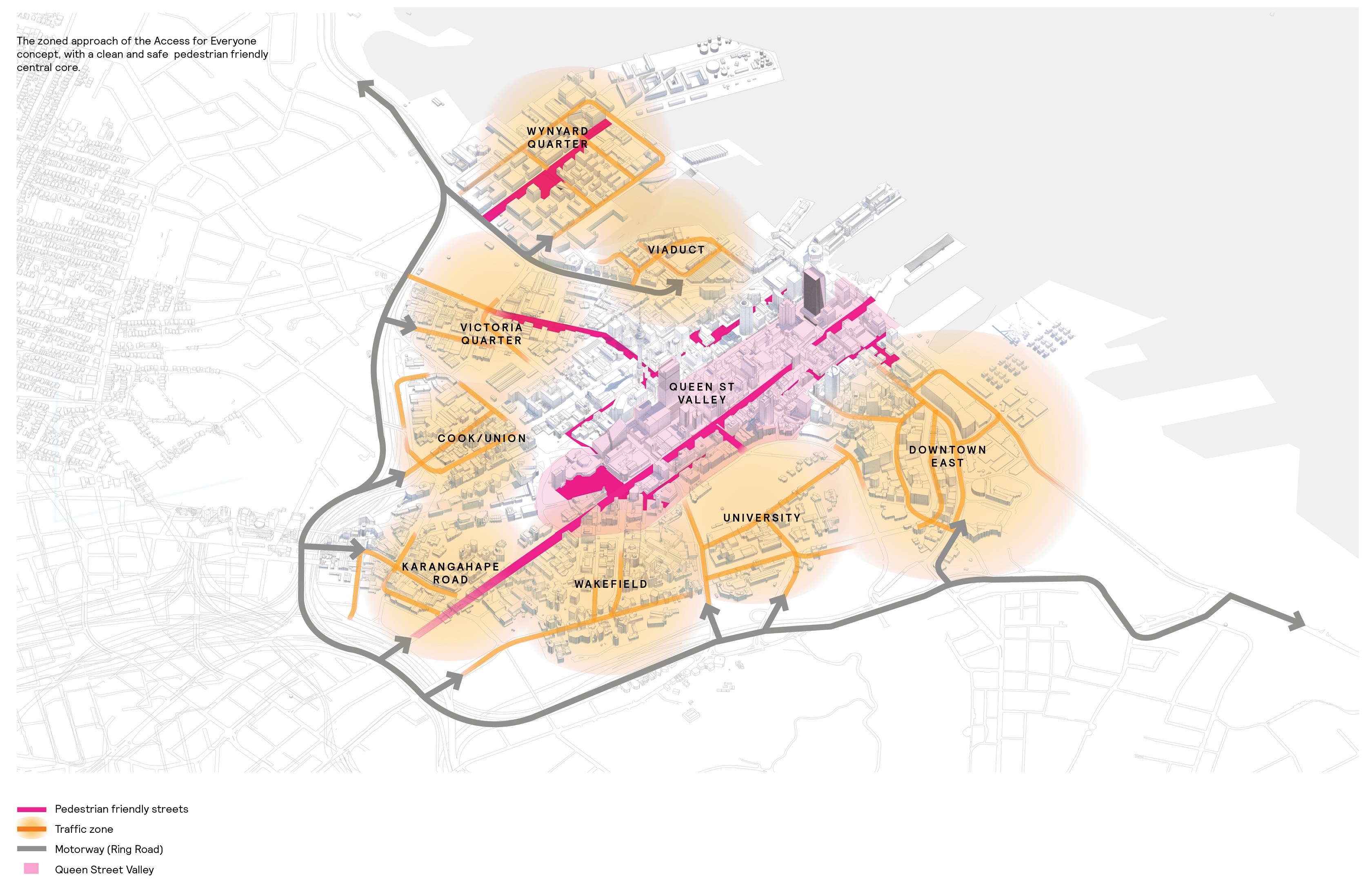
A4E is a big proposal and the whole thing won’t be rolled out overnight. Council will start with the Downtown East area and trial the changes to see how the concept works on the ground.
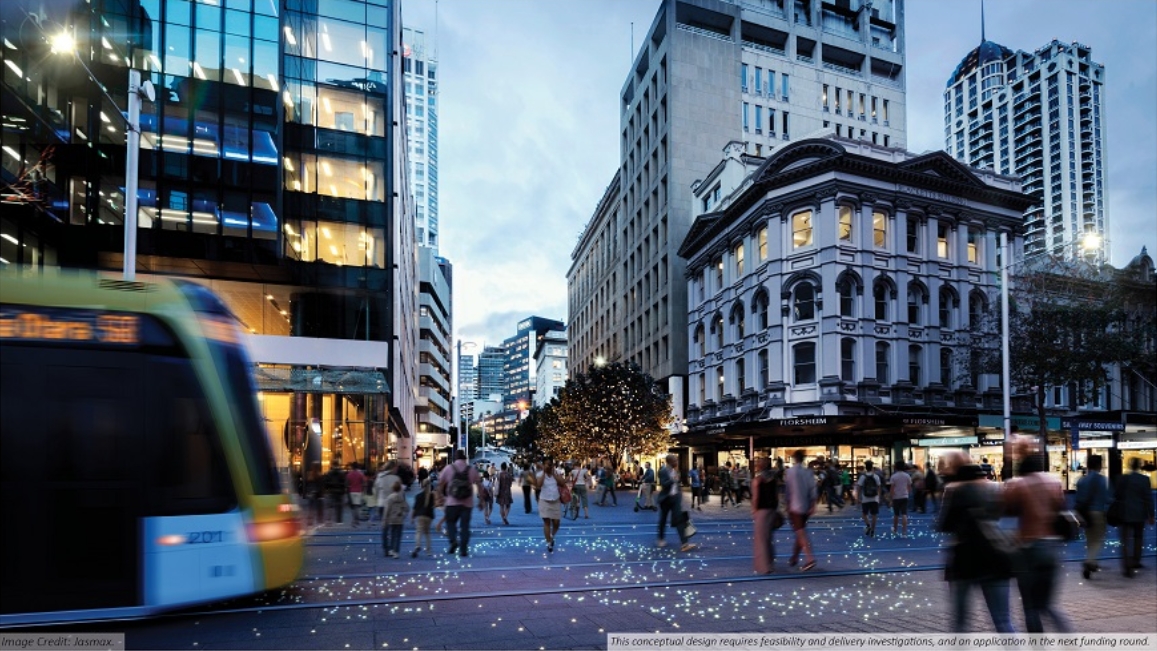
With cars eventually removed from Queen St, there will be no need for many of the intersections along it which will free up even more public space in the city, allowing for new plazas. The image below is a concept of what the Queen / Shortland St intersection could look like – with light rail also rolling through.
Grafton Boulevard
The area around Stanley St and The Strand might only be 800m from Queen St but it’s like a completely different world, and not a pleasant one if you’re not in a car (or truck). This is in part due to the planning blight created by uncertainty on the long term plans for SH16. This CCMP plans to change that with council saying:
The vision is to complete SH16 to Tāmaki Drive as a tree-lined multi-way boulevard to improve connections and access to the port area and eastern suburbs – creating a new eastern gateway to the city centre and extend the city centre’s vibrancy to the east.
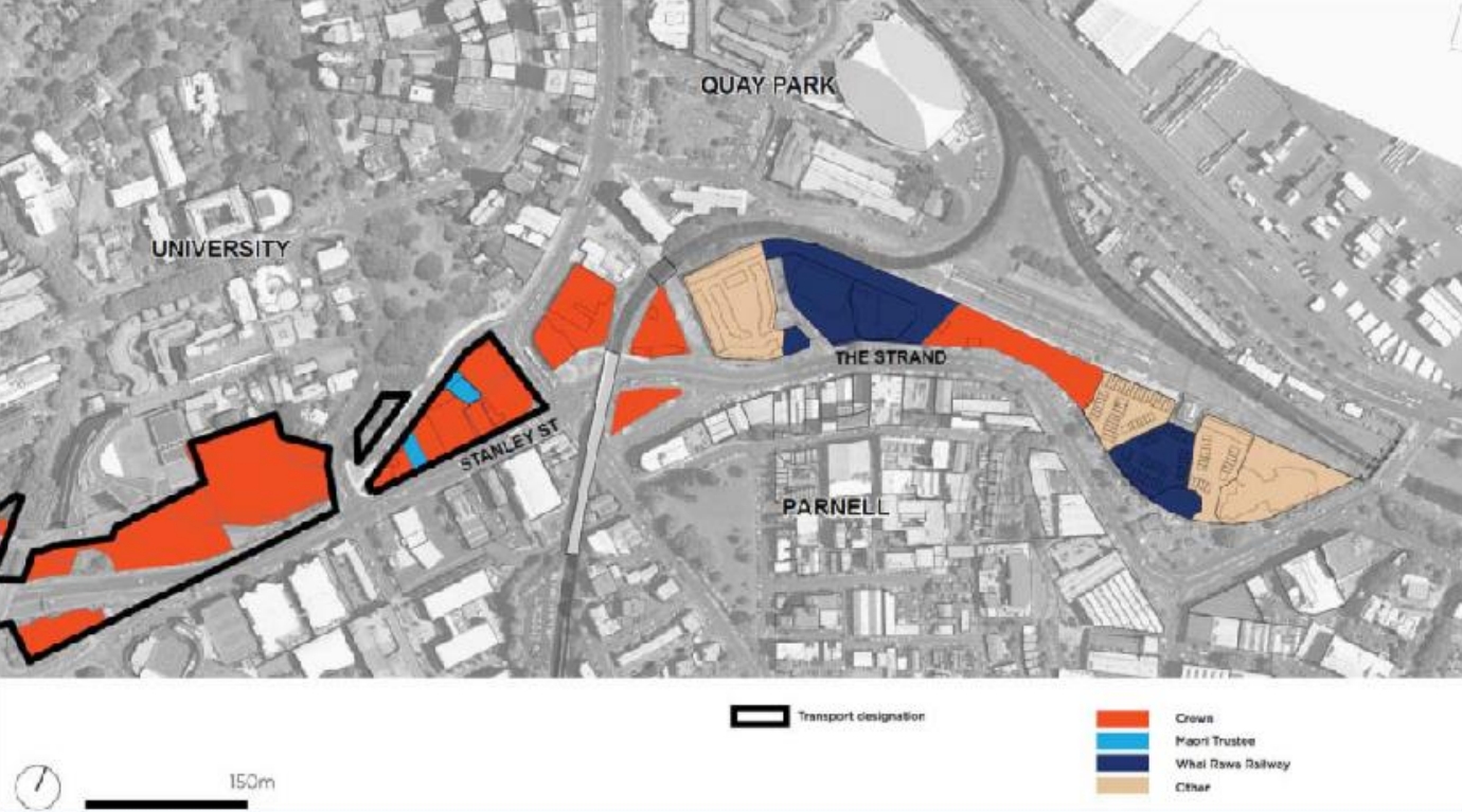
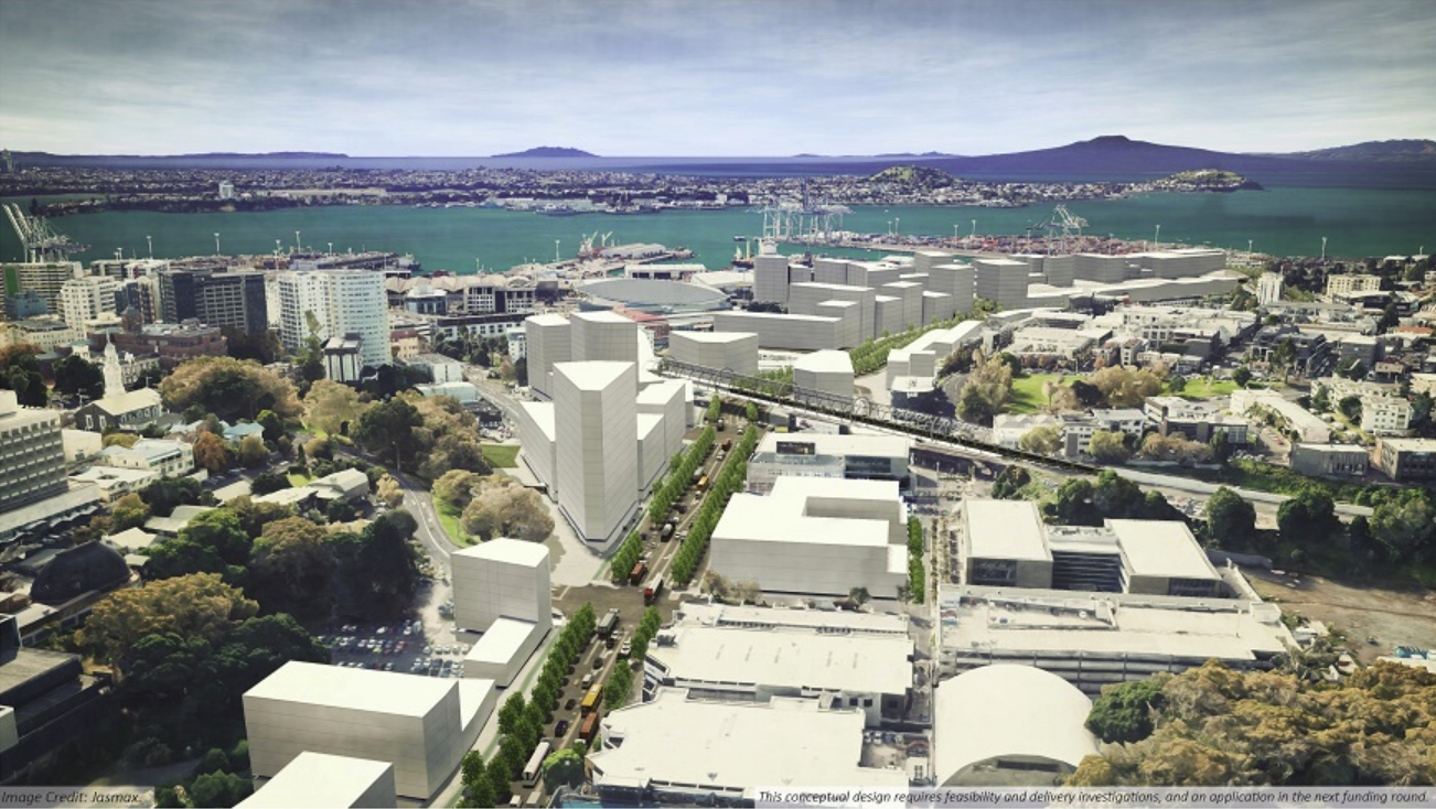
The area represents a huge opportunity for the city to redevelop and grow, much like has been happening at Wynyard Quarter. The images below come from a councillor Workshop uploaded as part of yesterday’s Planning Committee. They’re a little bit fuzzy but the first of these shows a map of the development potential and a comparison to the space available at Wynyard Quarter.
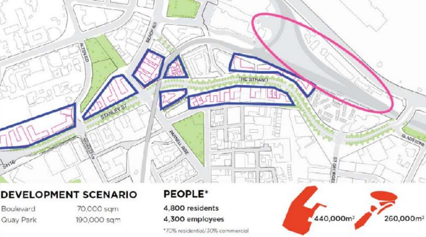
Much of that land is already in crown ownership.
Development here would also work perfectly with plans to reopen the tunnels under Albert Park.
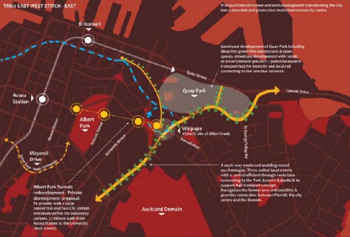
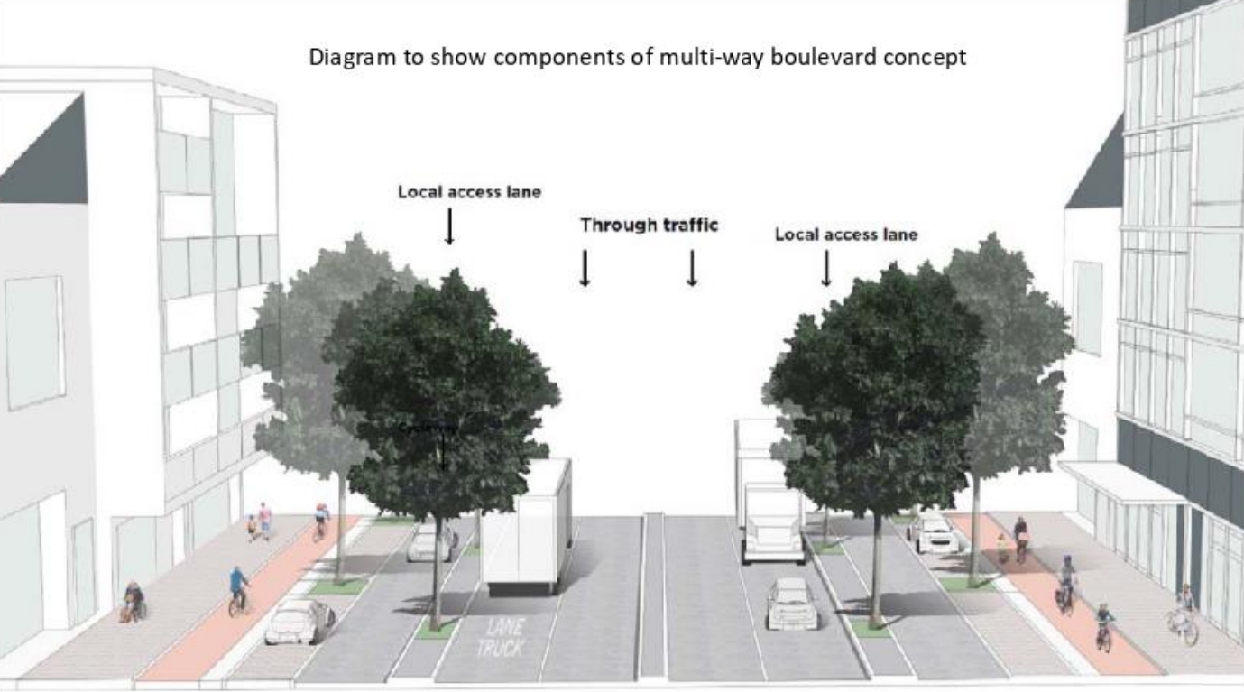
But the key change to enable this is to turn Stanley St and The Strand into a tree-lined multi-way boulevard – a street design that separates local traffic from through traffic. An image of how this would be laid out is shown below.
And a final image, an artist’s impression of what it could look like as from the air.
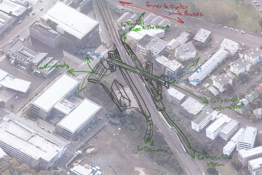
If this gets through consultation, it could be up to 20 years before it actually happens but hopefully will be much sooner than that. However, I do wonder if we’re really going to regret not putting the Parnell station in better location so that it could have not only served Parnell, via an easy walk up Heather St, but also been closer to the heart of all this redevelopment potential. Something more like below.
I look forward to the CCMP consultation coming out and we’ll certainly cover it more when it does. I’m also going to be really excited to see the and the A4E trial starting.

 Processing...
The walking link between the “Design Quarter” at the bottom of St George’s Bay Rd and the city needs more permeability. Earlier this year I was trying to walk from there to the Vector Arena (or whatever it is called now) – but the route is circuitous and ridiculously obtuse. It seems you can only approach Vector from the roads at the front? It is a very frustrating mess to walk around – cars non-stop everywhere and no thought for pedestrians trying to get anywhere.
Yes it’s currently a non-place sealed off from the city. Which makes some sense for a rail junction and yard on one hand, but on the other it’s crazy for a city centre.
Luckily that seems to be in their sights, the note above talks about green links, open spaces, mixed use development and a rail station in the Quay Park triangle.
Ngati Whatua have also talked about creating pedestrian links across the tracks in their master planning exercises. It should be fixed one day, although it might not be soon!
How does a vehicle get from Wynyard Quarter to Orakei without going through the CBD? Is a new on ramp required?
Yacht?
Western ring route
Yes but where does one access the Western Ring Route? See my next question.
Hobson Street on ramp. This proposal doesn’t ban driving to or in the city, it just has much reduced (but not eliminated) for driving across the city centre.
Once the Americas Cup has gone Panuku will connect all the wharf extensions with a new road across to the Queens Wharf extension (called a dolphin in the sales brochure) and then traffic will get diverted along a pedestrian way between The Cloud and the new ferry berths through where people are supposed to queue.
I think it’s the only way to accommodate the modelled demand.
The lack of on/off ramps on the western side of the city are problematic, but the plan is for Mayoral Drive to function as it was originally intended – a cross route. Nelson Street will be a major link still. Hopefully both de-tuned appropriately.
Like the plans for Grafton Gully but why does it take 20 years to change things for the good?
20 years? I don’t think it will be done that quickly. I can’t think of a single thing that was thought up specifically for the original City Centre Master Plan that has actually been built to date.
Re Parnell station.
Just connect it to the streets the way it was supposed to be before the cost cutting took place and it will be a functioning useful stop. As is, a waste of space!
Not a criticism of the access for everyone proposal, just a question for the once or twice a year I drive from Freemans Bay to the Eastern Bays foreshore and return. What will be the best route if Quay Street or Customs street are not available?
Currently you would access southern motorway at Hobson, uturn at Gillies Ave and go down Grafton Gully
I’d say Ponsonby Road/ Newton Road/ Khyber Pass/ Grafton Road would be the best bet. At certain times of the day this could already be a quicker option.
Or you could do Union Street > Mayoral Drive > Wellesley Street East > Grafton Rd, The Strand by local roads.
Or get on the motorway to Market Road or Greenlane round the back way.
Customs Street will remain a thoroughfare, but 30kph.
It will also be more efficient as there will be less conflict points with Queen St closing for vehicles.
Oops.
The problem with the Grafton Boulevard concept is it cuts off motorway access to people in the Eastern Bay’s. This would never get resource consent, as the effects would be considered significant. You would probably have to create a car/truck tunnel from Solent steet coming out at Grafton Road, to get this past consenting stage. Further without moving the port you are still going to have 100’s of trucks an hour going up &down the boulevard , ruining the pedestrian feel of the space. Once again this would be mitigated by a car/truck tunnel, but the problem is finding the money for this.
How does it cut off motorway access, wouldn’t they just drive down Grafton Boulevard in the through traffic lanes and access the motorway as they do now?
What do you mean cuts of motorway access? It would the motorway access from the Eastern Bays much better. Right now you have The Strand and Stanley Street as the motorway access road, perpetually clogged with only two lanes at the pinch point.
This would replace it with a six lane boulevard, with truck lanes according to the picture above. Surely that would be way better?
I don’t know how you keep 6 lanes & have a boulevard?
The figure in the post labelled “Diagram to show components of multi-way boulevard concept” may help.
Also having a look at boulevards in a few European cities with Google Earth/Maps.
It involves widening the whole corridor, redeveloping the land which is already mostly in crown ownership.
Relatively few existing buildings on that western slash northern side would require demolition and would be replaced with new developments.
The wee separateed local lanes on the sides are actually very vibrant for business in the places I’ve seen them.
I’m not personally against the idea. I’m just saying at the moment the strand is a main arterial connecting the motorway system & the port & eastern bay’s. The boulevard would presumably result in less lanes, more pedestrian crossings & therefore more congestion/slower travel times. There would also be a loss of on street parking. The effects would be considered more than minor & would therefore need consent under the RMA. These effects would have to be mitigated, how do you mitigate the effects, build a tunnel. If not the port business interests & the elderly eastern bay interests would fight the plan in a publicity battle & through the courts. From the environment & high court decisions iv’e read they would probably win. We couldn’t even get half of dozen pedestrian crossings in St Helliers because of the loss of 30 carparks. Sorry if I come across as cynical
Easy to get cynical, isn’t it?
Claims of “less than minor” effects have allowed road widening and motorway widening that has, in fact, turned local roads into on ramps and off ramps, and created severance with a huge knock-on effect socially and environmentally.
Agreed, “less than minor” effects is incredibly subjective.
Yes, and while wholescale changes to the RMA may be a great idea in the long run, the systematic misapplication of it isn’t hard to expose. We can do a lot to improve our planning simply by requiring balance in application.
That our engineers and planners have ignored the evidence of induced traffic, traffic evaporation, and the land use implications is well documented and understood at high levels in government.
Since roading investment leads to further and high requirements of subsidy, in the form of environmental, social and public health costs as well as road maintenance, whereas investment in the other modes has a net return on investment, any government from now on will need to look at better economic strategies around transport.
And since even the most neolib strategies of ringfencing the road user charges still required those funds to be used to keep cyclists and pedestrians safe, but weren’t, highlights that we must see a huge shift in funding priorities just to repay the debt to these disadvantaged road users.
The huge biases at each stage of planning and consenting can be resolved without needing to change the legislation; we just need a will to overturn the “rationalist techno-centric planning” culture at NZTA. I’m hoping this will come with changes at board and executive level.
I can’t stand the term. It is used very flippantly by planners everywhere. Makes my blood boil.
‘less than minor’ is a specific test in one part of the RMA but it isn’t applied for most road projects. The RMA allows ‘Requiring Authorities’ to write their own objectives for a project and then write their own consent for that project. The Council has to hold a hearing but they only get to make recommendations, the ‘requiring authority’ makes the decision themselves. I call the whole process the bastard child of the divine right of kings. Even better for really big projects they combine the Council hearing and the appeal into a one-step process and get a Board of Inquiry to rubber stamp it. Ideally they appoint a retired High Court Judge who hasn’t been given his knighthood yet. Those guys will approve anything for the government.
so that should read ‘ no more than minor’
Miffy you have honed cynicism down to an art form.
I enjoy your posts, don’t always agree with them, but one out of two ain’t bad.
Donny, the diagram above shows six lanes, plus cycle lanes, parking, trees etc.
Six lanes is not less than the existing, which varies between two and four. So it’s somewhere between double and triple the capacity for traffic.
And clearly there is not a loss of on street parking if its got street parking up both sides? Did you read the information above even?
See your point Nick, on closer the Strand is wider than I realised, about 30 meters. Still think you wouldn’t manage to fit the above though you would need at least 36 meters.
6 car lanes @ 3.5 meters = 21 meters
2 parking @ 2.1 meters = 4.2 meters
2 bike @ 1.5 meters = 4 meters
2 tree separation barriers @ 1 meter = 2 meters
2 foot paths @ 2.5 meters = 5 meters
Total 36.2 meters.
The parking would have to go IMO, Nevertheless I do agree the space could be dramatically improved without losing car lanes. I guess the other option would be to mix the bike lanes with the local access lane, you could almost make it a shared space like fort lane. This would also allow you to further increase the width of the footpath & remove the 3rd lane without removing the 3rd lane 🙂
If your widths are all correct, the choice would be removing the parking or purchasing the only bits of property that aren’t already in public ownership.
Removing the only space dedicated to micromobility isn’t an option. It would hardly help with establishing the lost cycling network! Not a fair use of the space, not in line with the Governmental Policy Statement on Transport, not in line with what Councillors of all stripes have been asking for – separation of micromobility and pedestrians, and not in line with the Auckland Plan.
I’m curious to know why you’d have thought tunnelling would be vaguely worth considering – given its enormous cost – yet not purchasing the only bits of land not only in public ownership in order to provide a multimodal boulevard? Obviously far less costly and far less disruption.
I guess I was thinking long term. I personally don’t think the space will ever have a great urban feel to it with trucks & heavy traffic running though it 24/7. The noise & diesel fumes etc. will make the urban environment average at best. I also believe it would be difficult to provide a great urban environment via the boulevard & at the same time provide a suitable main arterial for port/eastern bays traffic. These interests would conflict & the later would probably come out on top. A tunnel would allow the creation of an excellent urban environment in this part of Auckland. It would also connect the CBD to the domain & Parnell excellently. Developers would IMO be willing to develop the vacant sites abundant in this space & you would see urban regeneration. I would also toll it. I think costs would be somewhat reasonable if you use cut & cover. Check out the Dublin Port Tunnel.
The Dublin port tunnel cost over a billion dollars.
There’s a fair bit of severance that happens in the lead up to the portals of a tunnel, too. To date, the effects of this severance on the community have never been costed in NZ.
With the plan shown, the conflict between the sustainable modes, the port traffic, the eastern bays traffic and the local traffic will simply have to be managed using traffic light phasing and enforcement, to ensure the outcome is in line with the government’s plans for well-being, for places, for transport, for climate and for environment.
We’re not going to reduce our carbon emissions if we keep designing as if the vehicular traffic won’t reduce. Where the port traffic fits in that is even more challenging to the BAU mindset than where the eastern bays traffic sits, so the latter will probably have to be reduced while we all have a bit of deep think on the former.
But essentially, our children don’t have a future if we keep designing for things to stay as they are.
I could be wrong but I thought 3.5 metres was the standard width of a 100kmh motorway lane, lanes in a 50kmh zone wouldn’t need to be this wide.
You are correct, and in fact we often don’t achieve that on our motorways (Harbour Bridge central span lanes <3m). ATCoP and the AT TDM allow for lane widths as low as 2.7m in certain circumstances, although kerb face to line marking here could be 3.3m with 3.0m line to line. With no median this would give a width of 31.6 metres leaving all of donny's other measurements the same.
@donny is see the issue here, you’re assuming the status quo is kep.
The proposal is actually to widen the roadway to create room for a boulevard of six lanes plus parking, etc. You can see in the image above that the land along one side is already owned by the crown for a transport corridor, so widening by 10m is a relatively straightforward proposition.
See the aerial render that has grey boxes for new buildings all along the western side.
It’s probably a bit bigger than you have indicated also. The traffic lanes could be a touch narrower, but you’d need a central median/turn lanes. Also a tree median needs to be more like 2m wide if you expect the trees to actually survive, and in that sort of location you’d want wider footpaths.
My guestimate is it’s more like 40m or a little more. That’s about as wide as the central part of Fanshawe Street by the way, so it’s not unprecedented.
Actually while we are at it, can’t we give Fanshawe Street the same sort of treatment?
And what are practically motorway on/off ramps, Hobson and Nelson streets, could really benefit from this type of multi-way traffic separation as well.
“..Hobson and Nelson streets, could really benefit from this type of multi-way traffic separation as well.”
Could be traffic calmed further than Grafton I would think as eventually I’m not sure that it the pair of roads would need to be quite as “through traffic” like. It probably would only be so if we kept big parking buildings in the downtown area. All else can be via motorway or it’s just local access really, or better handled by jumping on a bus or LRT vehicle.
Would something like this be possible/desirable to eliminate that horrible, slow crawl around through Quay Park. https://imgur.com/a/Pevwgd0
Basically realign the rail line onto a new bridge crossing Stanley Street further north and begin descending into Britomart at Ngaoho Place.
As I said, I’m not sure if it’s even possible given the gradients at play or even if would provide enough of a speed edge to justify the expense.
Once the CRL opens only 6tph will use this section, these services will be the other end of the Western line services and will terminate at Newmarket or Onehunga.
This won’t warrant any expense on realigning the track.
Fair enough. I imagine that section will probably see few users as well given that it’s at the end of the Western Line and most of that line’s users would presumably be getting on or off at the city stops.
I suspect that in the future the realignment will be seen as a missed opportunity.
This is what Our Auckland said back in November 2018:
https://ourauckland.aucklandcouncil.govt.nz/articles/news/2018/11/council-green-lights-bold-new-city-centre-plans/
“In addition, new recommendations were raised and agreed for further development that will add pace and respond to Aucklanders desire to see action and progress:
– Trials and “tactical urbanism” initiatives to test and consult on the three new concepts – Access for Everyone, Grafton Gully Boulevard and Māori Outcomes
– Trial ‘Open Streets’ initiative in the city centre and work with interested local boards to trial in other town centres
– Consider an indicative programme of a rolling review of the City Centre Masterplan by July 2019; ensuring the development to the programme and vision is undertaken collaboratively across the council family and with external stakeholders.”
The only date mentioned has been met, which is fantastic.
If Council had put in a date by which the trials and tactical urbanism needed to have happened, would we have seen it by now? Had it happened over the summer and autumn, there would be much information to feed into the consultation. That’s a wasted opportunity.
Have there been any Open Streets initiatives yet? I think we were looking at a plan to have some in spring? Again, this could’ve happened over the summer and autumn, and be feeding real information into the consultation.
Consultation about ideas that haven’t been demonstrated is consultation designed to favour the status quo. It’s not democratic, and it works against the interests of young and future generations.
How do we get Council to put dates into their decisions and to design their consultation around giving people experience of the concepts first?
The biggest issue that I see with the Grafton Boulevard is that the three intersections at Alten Rd, Beach Rd, and Gladstone Rd are going to have to be huge.
Has any research been done into the cost of a tunnelled route?
A few cost comparisons from recent urban tunnel links might be enlightening.
The Victoria Park tunnel (3 lanes, one way) was $400m for 440 metres.
The Arras tunnel in wellington (2 lanes, one way) was $120m for 120 metres.
So we could assume that a Grafton Gully tunnel of 2 lanes in each direction will be at least $1m per metre. From the end of the motorway to Quay St/Tamaki Drive is 1,100 metres direct (or 1,300 if you follow the strand).
So quick estimate, a tunnel would be at least 1 billion dollars as a bypass. If it has an intermediate interchange to local streets you could almost double that.
Correct, not small change, but don’t you think it would be worth it? Creating a seamless high amenity urban environment stretching from New-Market to Wynyard quarter. A tunnel would allow this. This arterial seams to completely butcher the city IMO. I guess we may have to agree to disagree on this point.
I think the risk of the port relocating at some point would make this sort of spend too risky.
Bear in mind this boulevard is probably 20 years away, lets say the port is moved in about 30 years, that’s only 10 years benefit until the trucks are gone.
I’d expect it would be very difficult to prove a decent cost benefit ratio for such a short stub of motorway with that extreme level of cost. It is a moot point because there is no funding or even a line item in the 30 year plan for any city motorway extensions.
The boulevard proposal would deliver the majority of the vehicle reliability and travel time benefits for a fraction of the cost. It’s fundamentally just a road widening into land already owned by the crown and already designated for roads. If you factor in the land value uplift of that land it would likely pay for itself, which gives you a massive BCR. That’s the main benefit, the project costs would be measured in the millions rather than the billions. So it actually has a chance of happening.
The boulevard allows for seamless high amenity urban environment. Look at the boulevards of Paris for a famous example, or Octavia Boulevard in San Francisco which is an excellent example of the value of replacing a motorway with a boulevard. You only need go as far as Melbourne to see high traffic capacity boulevards working in very high value urban environments.
A tunnel could actually be worse for urban amenity, even if you had the money to waste. Consider the fact of the tunnel portals at either end, and what a monstrosity an intermediate interchange would be like (diamond interchange at Beach Road and Parnell rise?!). That would chew up all the land and put a huge blot in the middle of the area.
And if its a shallow cut and cover tunnel, which it would probably have to be, you wouldn’t be able to build on top anyway. So you’d lose the development potential, and kill off any chance of a vibrant development by missing the building frontage down one side of the street.
@Nick, all excellent points, you’re probably right
If they can do such a great job with this, it really does beggar belief why the Albert Street upgrade is such a dog’s breakfast.
Love the Grafton Boulevard idea. Haven’t had time to digest much of this.
I have had an empty feeling for a couple of years because a constant in my life had gone – that Auckland needed just one more road to complete the network. But now my life is complete and not only a new road, but a boulevard (apparently that’s a road with a couple of trees.)
Forgive me that I don’t come from an engineering background where it seems that acres of new tar seal provides real excitement. From my humble business background here’s what I don’t understand:
1) if the Auckland area needs to reduce car travel by 50% why do we need a wider road here?
2) If Auckland is headed for centre city mode share of less than 10%, and it seems it should be because this is the easiest area from which to remove cars given all the other alternatives, why do we need a wider road?
3) Isn’t the future location of the port a vital part of whether this road is needed?
4) What exactly did the Mayor mean when he said this on 12 June, “We will certainly need to reprioritise our spending around the challenge of climate change.” (even though I didn’t pass English after the fifth form I do realise that there is a difference between, “will need to” and “are going to.” Will this endless focus on roads and parking ever disappear?
4) Again from 12 June “One of our key focuses, for example, will be the area of transport. In Auckland, 40 percent of our carbon emissions are from transport. We’ve started making big changes already, we’re trialling electric buses, we’ve started converting the council group’s fleet to electric cars, but we’ll probably have to move much faster than what our current plans provide for and then we’ll have to pay for that as well.” I am deeply concerned that trialing electric buses is his best example of a big change; but what are the plans to move much faster than the current plans provide for? (I suspect that he has never had much time for the 30kph limit and is signalling this).
I am concerned that Auckland appears to be doing little to address climate emissions because almost daily there is another bad news story:
“Antarctica hasn’t showed as much consistent warming as its northern Arctic cousin.
“But the fact that a change this big can happen in such a short time should be viewed as an indication that the Earth has the potential for significant and rapid change,” University of Colorado ice scientist Waleed Abdalati said in an email. (talking of a huge decrease in Southern ice, “But three years later, the annual average extent of Antarctic sea ice hit its lowest mark, wiping out three-and-a-half decades of gains – and then some, a Nasa study of satellite data shows.’)
I am generally a glass half full type of guy, but I am really concerned that much of that might become melted ice. Let’s turn the focus away from car travel for all our sakes!
You’re not wrong, John. Of course this is all about the port. It’s also about our inability to see the benefits of a circular economy, of scaling back our consumerism, of looking to a socially just and environmental way of doing business.
If keeping the port there can be compatible with a good public realm, it needs to be demonstrated. I doubt we’d achieve one lane each direction at this stage in the climate change (un)awareness game. Later, sure, but we need improvements now.
With serious vkt reduction targets in place, a design like this to accommodate the port traffic would have to be accompanied by severe road reduction elsewhere.
I’d say the benefits of the Grafton Boulevard are primarily about land use. And that in realising those benefits we will also realise more sustainable land use and transport outcomes.
Right now, this enormously valuable section of inner-city land is lying largely fallow due to a combination of (1) state highway designation and (2) a poor street environment.
What the Boulevard does is provide a multi-modal corridor that addresses both those issues at once. In one fell swoop the project will unlock the development potential of the area and you’ll see many more people and jobs move close to where they need to be.
Stu
I take your point about land use, but surely that could be achieved with a more appropriately sized road?
And does the pictured boulevard offer anything in terms of creating a place? It just looks like another Hobson St to me.
Someone talked of the boulevards of Europe. This is nothing like I remember, last month. In Milan I remember wide roads with a huge wide green space that was treed. On that space was often the bike way. In Vienna the same. I didn’t bike,but I saw huge numbers that were, under the trees and amongst the leaves.
I am struggling for the word that best describes the sketch, but I am going with barren.
I also wonder what the demand for road space would be if the city was subject to a congestion tax. It is economic folly to build infrastructure first and then tax subsequently; but I don’t need to explain that to an economist.
John, I suppose when the authorities get real about vkt reduction, the middle four lanes can be repurposed as mixed use urban land, flanked by two one-way lanes. Be quite nice then. :/
Passeig de Gracias in Barcelona is a great example of just how good these multi-way Boulevards can be.
Do you have a link Scott?
Link here:
https://goo.gl/maps/kCBEDJbDGJ7nuiLv5
That link unfortunately hardly does Passeig de Gracia any justice. It’s one of the great streets in Europe. It’s a through street for traffic coming and going from Avinguda Diagonal, one of the big cross town routes in the city, and the port area of the city and it’s also a really densely populated residential and shopping street for Eixample, the ritziest shopping street in Barcelona in fact. If Grafton Boulevard was to turn out even a little bit like Passeig de Gracia it would be one of the most successful streets in Auckland
This view from the side at the same place probably does it better justice, representing more of the view from the ground rather than from the middle of the traffic lanes.
https://www.google.com.au/maps/@41.3884566,2.1692878,3a,75y,153.56h,93t/data=!3m6!1e1!3m4!1sXZRMNIb6Rmf4mCrukAr76g!2e0!7i16384!8i8192
And of course the ultimate Boulevard Avenue 9 de Julio In Buenos Aires:
https://www.google.com/maps/@-34.6062907,-58.3812706,3a,75y,357.67h,90t/data=!3m7!1e1!3m5!1sIYHxb3Dc01AJkOSR6b-flg!2e0!6s%2F%2Fgeo0.ggpht.com%2Fcbk%3Fpanoid%3DIYHxb3Dc01AJkOSR6b-flg%26output%3Dthumbnail%26cb_client%3Dmaps_sv.tactile.gps%26thumb%3D2%26w%3D203%26h%3D100%26yaw%3D129.77849%26pitch%3D0%26thumbfov%3D100!7i13312!8i6656
Which is hardly climate-ready. I like this one from Barcelona. It reminds me of what’s proposed here, with the trees flanking the central lanes, then side lanes and parking:
https://i.imgur.com/016MztU.jpg
Except of course, to get the city’s air pollution in line with the EU’s requirements, they removed traffic from the middle ones.
We like to spend money twice.
No, that’s for sure! From memory it has 18 vehicle lanes and four bus lanes.
9 de Julio is a interesting case. It’s actually not so much a boulevard as a highway between two streets.
Initially it was just another row of city block with streets either side, on the very regular street grid of Buenos Aires. But in the late 1930s the started to demolish a row of buildings to build a monumental through route, taking a cue from Paris.
So what looks like the side lanes of a Boulevard are actually just the streets either side, while the middle section replaces a whole city block wide between them. The side lanes actually retain their original names, Calle Lima to the west, and Calle Bernardo Irigoyen to the east. This is often called the widest road in the world, but its debatable whether it is one road or three!
It is an interesting case because they created this monster boulevard thing instead of pushing an elevated motorway viaduct through downtown, which is what they mostly did nearby. Which is the lesser evil? 9 de Julio certainly is grand and majestic, and does function as a sort of long plaza/square/park for the city.
Also, the clearance made it very easy to build the metro underneath, and recently the busway above. That probably wouldn’t have happened with an elevated motorway.
Check out this great GIS viewer from Buenos Aires city showing historic photographs. It’s in Spanish but Fotografias Historicos is pretty easy to find: https://mapa.buenosaires.gob.ar/mapas/?lat=-34.604575&lng=-58.378869&zl=16&modo=transporte&map=fotografias_aereas_1940_caba_3857
Avenue 9 de Julio is certainly an impressive street but it’s not a multi-way boulevard as has been proposed for Grafton. There’s no separation of thru traffic and local traffic.
https://www.google.com/search?q=main+street+vienna&tbm=isch&source=iu&ictx=1&fir=MOjHR5oG8xGfuM%252CDKYfM–1_wECIM%252C_&vet=1&usg=AI4_-kSDxtkKBWKiYnBo_8VCWK4sib43Mg&sa=X&ved=2ahUKEwj07vTpy5jjAhUCWX0KHa7JBNQQ_h0wGHoECA0QBA&biw=1280&bih=657#imgrc=MOjHR5oG8xGfuM:&vet=1
Images of my favorite street in Europe. Where are all the cars? How can this be? 1.8km of walking space. And since 1994. Sadly its not a boulevade, or is it.
Ah, but our boulevade might have more trees.
Auckland really needs to learn to render potential developments correctly. That grael car park at the back of the uni is shown with 2-3 storey buildings on it when the whole gully has high rise residential buildings. As a result, the new residential capacity is comically low at ~4000. You’d probably get 4,000 people in four buildings on that site!
It undersells the concept and makes us forget that this would almost pay for itself.
This CCMP has not address these important issues
– Victoria Quarter (Sale st/Union st/cook st) remain to be a hostile pedestrian wasteland
– Eden Terrence Area (Still a wasteland)
– Urban Schools (To stop family from moving out to suburb once they has kids, unlock a market for owner occupied family apartments)
Yes, and Victoria Quarter is where a lot of apartments are, and what a lot of people remember if they think about apartments. I would think that situation is incredibly damaging to any effort to promote density. But there seems no urgency to improve it.
Notice in this image of Passeig de Gracia that Nick R put up how narrow the local traffic lanes are between the pavements and the busier thru traffic lanes. They’re barely as wide as the vehicles that use them. As a result the traffic in those lanes is pretty much forced to slow down which makes for a much more pleasant pedestrian experience.
Octavia Boulevard in the Hayes District of San Francisco (the likely template for what is proposed for Grafton) built their local traffic lanes wider so the traffic tries to move faster through them and it has been acknowledged that in the context of the balance between pedestrians and vehicular traffic this was a mistake.
https://www.google.com.au/maps/@41.3884566,2.1692878,3a,75y,153.56h,93t/data=!3m6!1e1!3m4!1sXZRMNIb6Rmf4mCrukAr76g!2e0!7i16384!8i8192
Hey Awesome Guys but can we have Polite debate on my submission one point I wanted to consider else love it..
” Our Place in the World” should also recognise the Pacific Island cultures, European influence, modern Innovation and even a Japanese aspect influence along side awesome Maori Cultural Art and Influence.
?