Auckland’s City Centre Masterplan of 2012 was a visionary plan to help reshape the city into a more people friendly area. Many of the things it proposed have been or are in the process of being delivered. One of the more exciting proposals in it was creating a green link between the Domain and Wynyard Quarter, connecting Albert and Victoria Parks along the way.
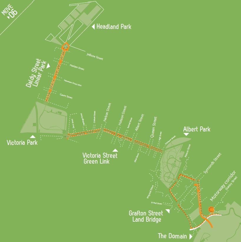
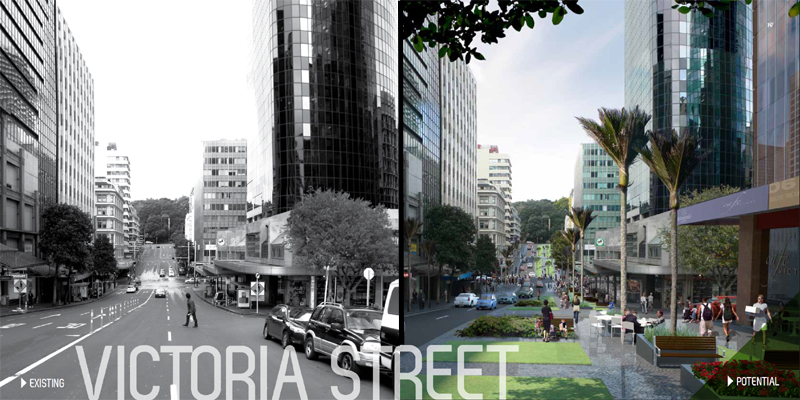
The key central section between Albert Park and Victoria Park would be achieved by creating a linear park along Victoria St. More public space in the city centre will be crucial for both visitors and the rapidly growing residential population – the fastest growing area in the country. Note: The city centre population has grown so fast that at about 57,000 people, it has already well exceeded the 2032 expectation in the CCMP of 45,000
The opportunity to build the Linear Park was almost lost a few years ago after Auckland Transport ignored the CCMP as well as their strategic plans and business cases by proposing to use Victoria St to funnel buses through the city, an option that had a negative benefit cost ratio. Thankfully following public feedback they eventually gave up on the idea.
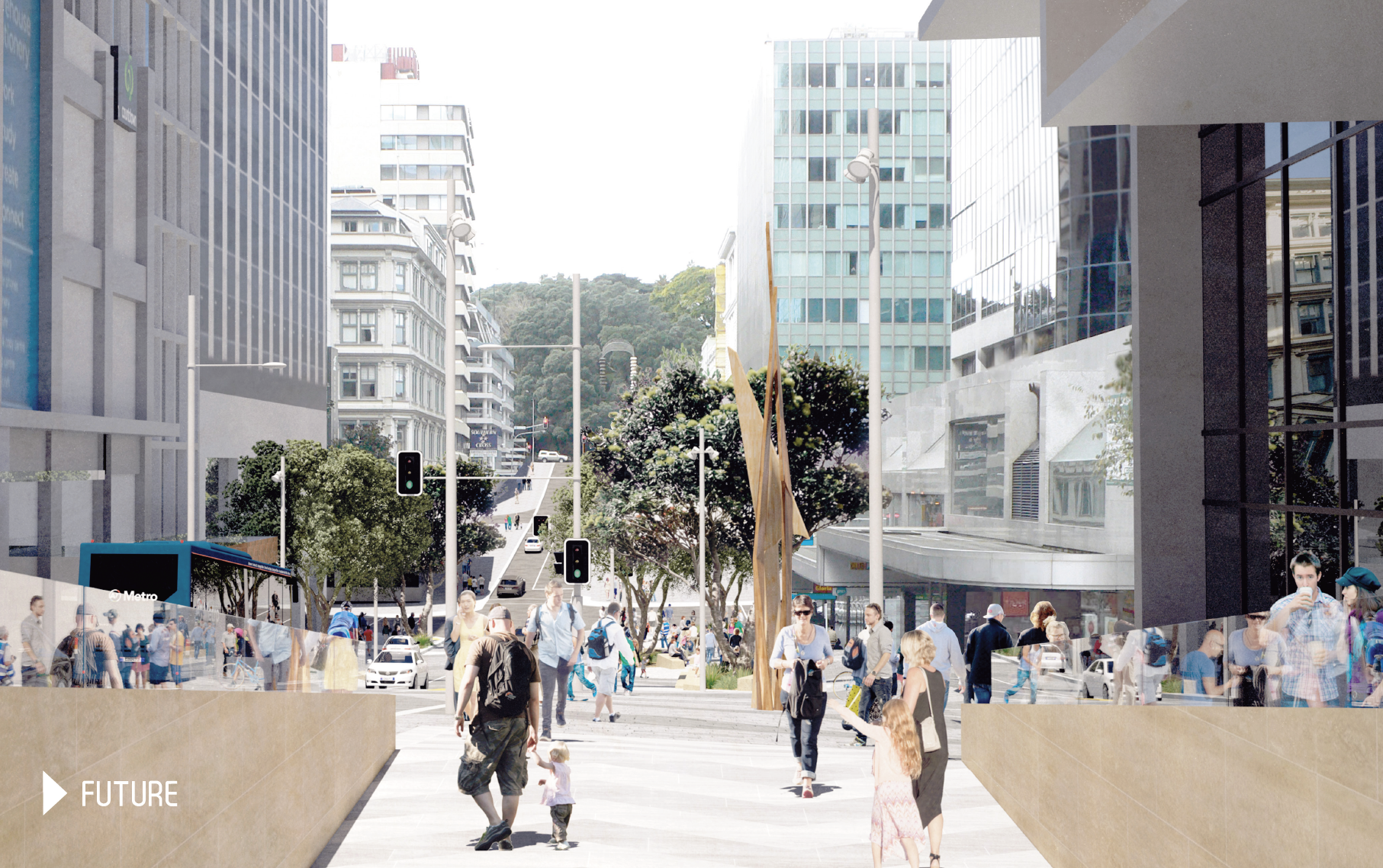
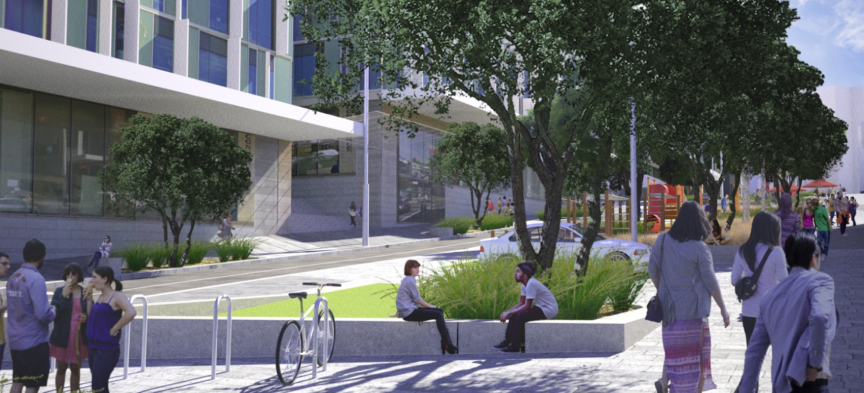
Despite the name, the Linear Park isn’t just about pretty pictures or providing a green space in the middle of the city as in some places it won’t look like a park at all. That’s because it will also be serving some crucial functions. In particular it will be needed to help distribute the thousands of people every hour who will pour out of the Aotea Station being built as part of the City Rail Link.
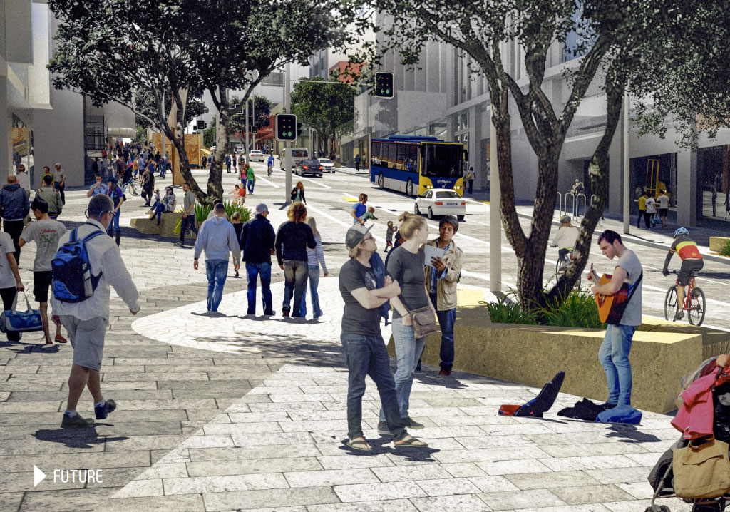
The station entrance on Victoria St will be within the Linear Park space and modelling has suggested it could see over 5,500 people an hour at peak times – although given the CRL will now cater for longer trains, that could be even higher.
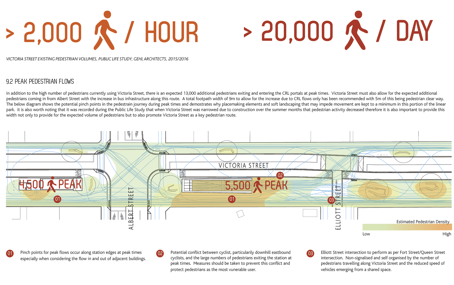
Further away from the CRL entrance there’s likely to be a greater ability to have more green space included in the design.
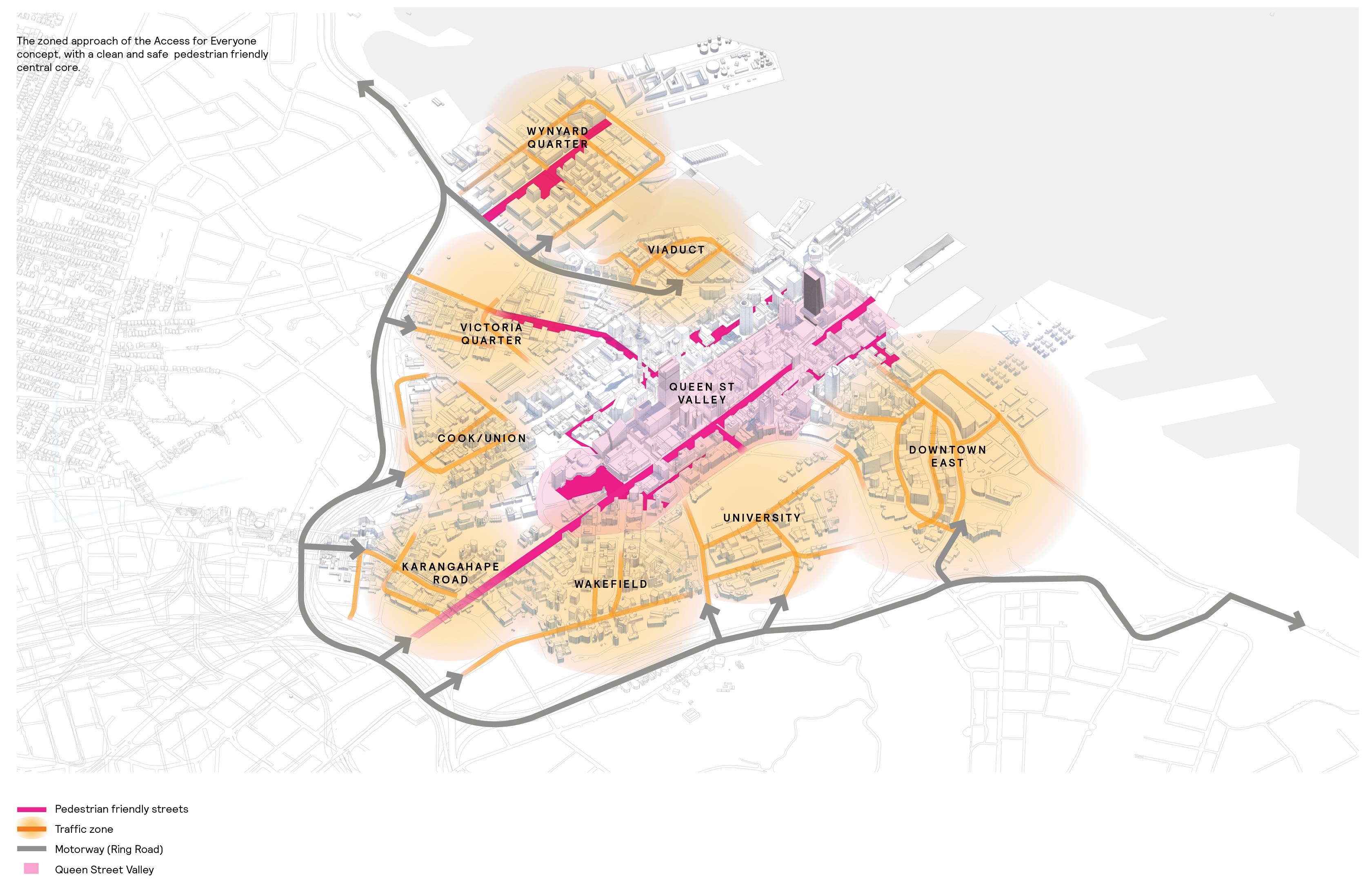
More recently, and part of the refresh of the CCMP, the Linear Park will play a crucial role in the Access for Everyone proposal that intends to make the city centre much more pedestrian friendly.
So why are we talking about this, yesterday we finally heard a little news about the project.
The Victoria Street Linear Park is one step closer with the awarding of the contract for the development of the business case. The contract has been awarded to Jacobs New Zealand Ltd who will also work on the conceptual design.
The Linear Park will create a pedestrian friendly link between Victoria Park and Albert Park.
“It’s good to be one step closer to creating a great space for people in the middle of our city. If you look at other linear parks around the world, including the world-famous High Line in New York, you can see how they transform cities,” said Mayor Goff.
“The project is still some years off completion, but the business case and conceptual design begin what we need to do to bring this project to fruition.
“Aotea Station will be the busiest passenger station in Auckland once the City Rail Link opens. Having an attractive, people friendly link going down Victoria Street at the station entrance will make a huge and positive difference to people using our city centre.”
Chair of Planning Committee Councillor Chris Darby said, “The thin green line of the park pierces the densest and busiest neighbourhoods in Auckland. It significantly increases the amount of green public space through the midtown area, where a significant deficit in open space exists.
“The linear park dramatically improves connectivity for pedestrians and cyclists reaching the city-centre and universities, with potential to extend to Parnell via the rediscovered Albert Park tunnels.”
Deputy Chair of Planning Committee Councillor Richard Hills said, “It’s fantastic to see this crucial milestone on our green link through the city centre. It will connect our parks and eventually connect pedestrians and cyclists with the walking and cycling route over the harbour bridge.”
It’s a bit hard to get too excited about a business case contract being awarded for a project that a) shouldn’t need one and b) is many years away from being implemented, but it is good to finally see some progress on the project. One thing I do hope we will see is ways to start putting parts of the Linear Park in using temporary placemaking tools so we don’t have to wait for the whole project to be designed and funded before we get any progress.
Finally, as Darby mentions, one of the other interesting opportunities the Linear Park would provide is that it would link directly into the Albert Park tunnels which we’d love to see reopened.

 Processing...
I really love the Linear Park idea. It is just so cynical that I laugh out loud each time it comes up. “Let’s build a really wide paved area and tell them it’s a park” sounds like it came straight out of some dictatorship where everyone can see it’s not a park but where everyone knows it is in your own best interest to call it a park. It deserves full marks for being so amusing.
Wellington’s waterfront is largely paved and must be the most popular recreation area in the city. Sometimes “park” = grass; sometimes not.
Call it the linear plaza then? Could call it the linear square but that makes my head hurt.
Linear Square is good. Maybe Linear Circus would work, I mean it is neither straight nor is it round, so that seems like the type of thing the Council would go for. There is no requirement that the name should match actual geometry, St Peters Square is round.
Why not call it the New Forest? Better yet what about Car Park and have no parking.
I like that last one. We could have a full city that is a car park, and one little spot, called Car Park, that isn’t. Ha ha ha.
What about calling it Park Car-Free? That will really confuse people.
Renaming it could give it real identity – the High Line is iconic.
Linking Victoria & Albert, surely there’s a play on words available!
Kuini Path (Queen)
Wheao Path (leader, chief)
Karauna Path (crown)
Marry Your Cousin Way?
Except she possibly wasn’t his cousin. The theory is she wasn’t the daughter of the Duke of Kent at all. A N Wilson thinks it more likely she was fathered by John Conroy. So what about Lucky To Be Queen Park.
If you’re looking for a Victorian word it’s “Promenade”.
As opposed to “Green Link” which sounds like a golf course,
In effect this is a wide street. So you could call it an Avenue or a Boulevard.
Still the elephant in the room of that great gaping hole—the site of the Royal International Hotel— that for the past forty odd years has functioned as a car park bang in the middle of Victoria Street. If ever there was a failure of planning and light touch regulation, it’s that particular space. It has the potential of stuffing up every positive move and, to all intent and purpose, seems to have been ignored amidst all the spin surrounding the linear park concept.
I wish it could be turned in to a recreational park. Plenty of room for grass, playgrounds, gardens, inner city football and tennis, markets. Imagine! The skycity car park expansion will compensate for removing this one.
A little bugbear of mine, I think this thing is conceived in the wrong direction.
This gets described as a pedestrian link between Victoria Park and Albert Park and an east west corridor. Personally, I think the value is North-South. Rather than a long linear park running across the city, I see i as a string of a dozen little parks and squares intersecting the north-south flow of the city.
The difference is that I think very few people will walk right along the length of it each day, but far more will engage with one or other sections.
Like between Albert and Queen it will be a paved square that mostly functions as a concourse for people going to and from Aotea station. From Queen to Albert Park it will be a pedestrian route up to the university. From Albert to Hobson it will function as an extension of the skytower forecourt, and from Hobson to Nelson is perhaps the only place it will be an actually green park for the thousands of residents up that way who desperately need something.
All very useful, all will be great places, but different functions. Not really a linear park.
I agree that there is lots of north-south movement, so let’s do both!
1. Victoria Street (east-west)
2. Queen Street (n-s): pedestrian and transit mall with lots of parklets
3. Hobson and Nelson (n-s): convert to two-directional, and one of them de-tuned with bus lanes etc.
The western side of the city is a huge growth area, and once City Works Depot is developed, there will be massive population growth on top of the existing apartment communities. They need transport, parks, and safe streets!
Well Queen and Albert are the north south streets where vehicle space is to be repurposed into for both pedestrian movement and loitering (place).
Additionally, the CRL will turn a great deal of what is now north-south pedestrian movement into east-west, particularly on Victoria and Wellesley, because people who now have to walk down to Britomart instead will be walking across to those entrances to Aotea Station. Especially from the universities, but the Queen St Valley in general.
That is one of the major directional shifts the CRL will deliver to the city.
True, that’s quite a big shift. Should go well with turning Queen into PT and pedestrian only.
Yes that huge shift of movement direction is a good point.
Different parts of Victoria Park function differently but that is still a park. Why is this different?
Because Victoria Park doesn’t have the word Linear in its name.
Just follow Hidalgo…
https://www.citylab.com/environment/2019/06/paris-trees-famous-landmarks-garden-park-urban-forest-design/591835/
Business case? They’ve already decided to do it, right?
So is there not a better description of what this next step should be? Design, maybe? Planning stage? It’s not like any economic evaluation we use in this country will be useful for a project like this – we see that all the time. There just isn’t any way the full benefits or costs of different scenarios will be enumerated properly. Let’s not pretend the bean counters in NZ have shown themselves capable of this sort of thing.
The very words business case will bring all sorts of bad mindsets and processes to the table.
I am cynical but I see business analysts as being extraordinarily good at ensuring they get themselves a place on the costs side of the ledger on every project, including added time, but their contribution to the benifit side, is at best debatable. Many simple projects seem beset by over analysis and over consultation.
Have AT drawn up the alternative bus routes to avoid using victoria street? There was talks of a terminus in Grafton gully for NX2 & north shore routes. I guess this all ties in with Quay street work and opening of CRL. Would be nice to see this all coming together, but it still seems a long way away
Details here: https://www.aucklandcouncil.govt.nz/plans-projects-policies-reports-bylaws/our-projects/project-akl/projects/Pages/wellesley-street-bus-corridor.aspx
This park will be a great improvement. A completed CRL can’t come soon enough. Wonder what can be done before hand realistically with this and the Wellesley St bus corridor in the meantime. Maybe a section of these could be done first.
On a practical level you would presumably want the Wellesley work complete before work commenced on Victoria just to minimise disruption to buses.
The other consideration is political, you want to your shiny new station next to a shiny new linear park and not a construction site and Vice Versa. So at a minimum I’d expect the Aoetea section to be completed concurrently with Aotea station?
You think both could be done on the Eastern sides of Queen & through to a partial sections of the west if you wanted to keep away from CRL works. Then station entrances and surrounds then done later. Haven’t thought too hard weather that could work though on a practical level.
Great concept but the pictures aren’t very appealing. They look too much like the present Queen Street to me, just with wider footpaths. Could it work with no vehicle traffic at all?
They’ll have to make it work with no traffic eventually. We’ve seen that places that are clearly meant to be pedestrian realm are abused by drivers parking there (Vulcan Lane, New Lynn around the community centre, thousands of examples, city-wide…) It appears the only way to prevent this noncompliance is to exclude cars completely.
Or we could just enforce our Parking and Traffic rules. It’s 2019 and we still haven’t figured out how to use cameras easily to fine people for illegal parking, running red lights, speeding etc..wouldn’t need a regional fuel tax!
Technology will be very useful when we’ve acquired a will to enforce.
No need for high tech. You need to:
– hire a parking warden.
– buy a bike;
– buy a large stack of blank parking tickets
Repeat if necessary.
I have seen people getting a parking ticket on Elliott Street before. Doesn’t seem to deter much though. In the end I think it is going to involve bollards.
As to parking on the footpath, I don’t understand how that is such a problem here. Many European countries managed to keep cars off the footpath. None of them needed fences or bollards for that, a simple kerb gets the job done.
Do they have a scooter/cycle way that are not shared with pedestrians, similar to Beach road?
Such connection will be very popular.
Well the plan above seemed to show a separated cycleway, so that’s good. What always peeves me is that when it comes to the intersections, it gets merged into the pedestrian space. Really, it’s not that hard to provide separate walk & cycle facilities right up to and through intersections.
Well those facilities are really ugly and don’t look nice on expensive artist renderings. So lets just forget about them.
I think mostly is that NZ hasn’t figured out how to do cycle facilities. We really only get two options. The safe cycle phase where you wait forever, or the unsafe cycle lane mixing with general vehicles where you don’t have to wait long.
It is only “shared” with pedestrians on Beach Road because pedestrians don’t walk in the right place. And so cyclists have to weave around them and then get dirty looks for riding on the “footpath”.
One thing about the existing plans etc is there is lack of any design for the east section from the Queen St valley up to Albert Park, most/pretty much all the renders etc show the west side with a distant view of the east at best.