Yesterday the council unanimously voted to adopt the plans update the City Centre Master Plan and help make the city better for residents, workers and visitors.
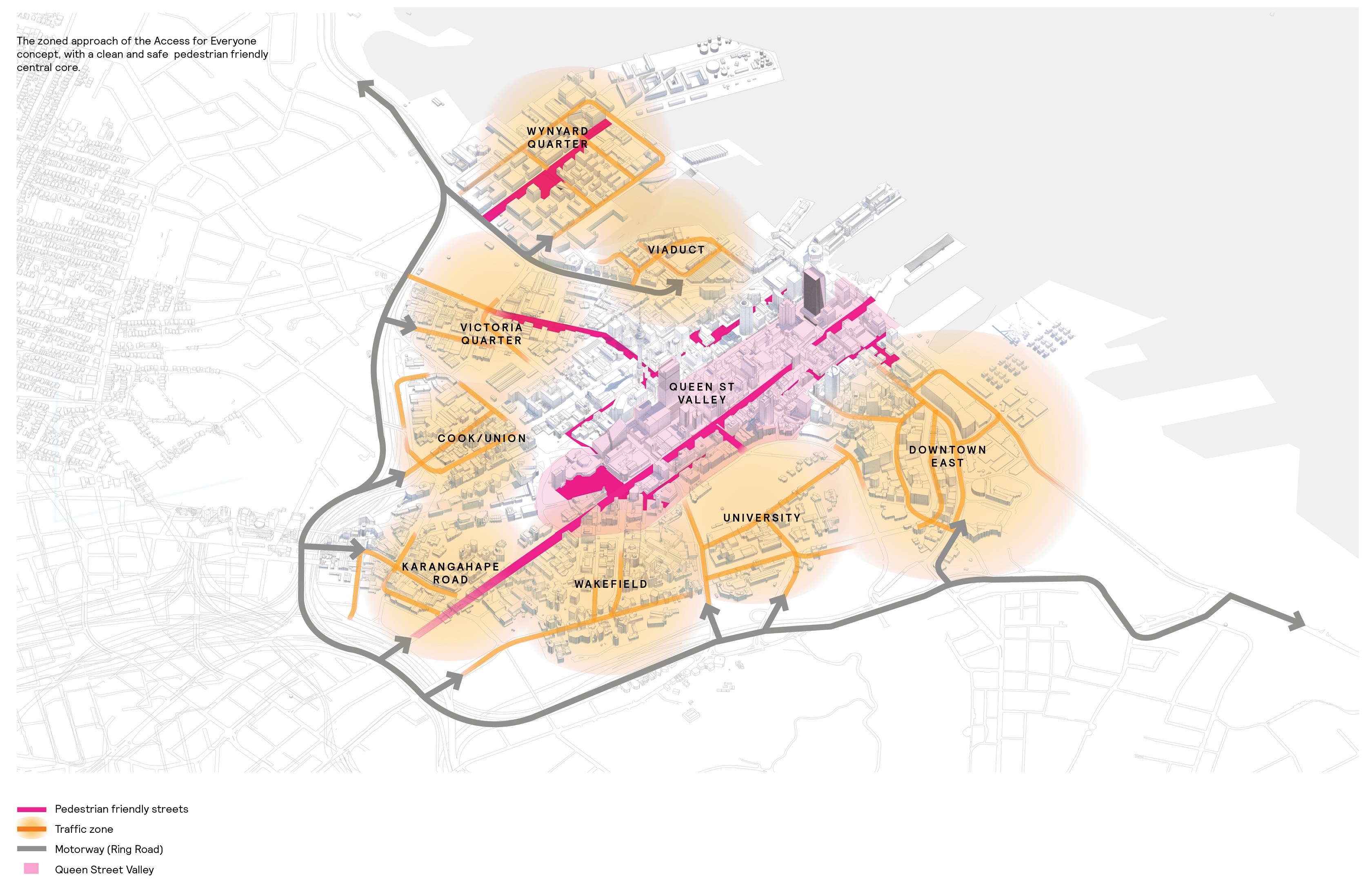
The biggest change is what has been called Access for Everyone (A4E). This will see Queen St, which has 13 times more pedestrians than cars, and some adjoining streets become pedestrian, bike and public transport only.
Outside of the Queen St valley, the city centre would be divided up into eight zones. Pedestrians, cyclists and public transport would be able to pass between the zones but cars and trucks wanting to get across the city centre would need to exit back out to the motorway edge and go around the city. This means that only those vehicles that need to be in the city will be there and the council suggest this could reduce non-discretionary vehicle trips by up to 20%. Already more people live in the city than drive in the mornings and non-car modes account for over half the people arriving in the city morning. With CRL, Light Rail along with other bus and ferry improvements, capacity on PT is expected to increase by 370% in the coming decade.
Last week the concept was showing in a series of high-level drawings but the council have now released a much better image to explain the concept. As you can see, there are number of zones where the streets have been disconnected from each other. Note: I wouldn’t take this as a final version as there is bound to be a lot of work needed to confirm all of this and some zones will be easier to implement that others.
One particular movement I look forward to not seeing in the future are the large trucks that rumble along the waterfront to get to and from the North Shore rather than use the motorway to go around the city. Especially as that enabling that was one of the key justifications for upgrading the Central Motorway Junction in the early 2000’s.
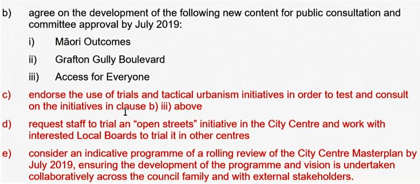
On top of unanimously supporting A4E, the council went further and added the items in red below. It’s great to see them supporting tactical urbanism as that can help enable us to see some of the outcomes much sooner and cheaper. As we’ve said many times before, Queen St is unique and there’s no reason for a car to be there, there are no driveways or loading docks on it. Cars are only there because we let them be there. Importantly, the A4E work would have been needed at some point anyway as it’s a pre-requisite for when light rail is installed. Getting it agreed now, and even better, a tactical urbanism implementation, will make it easier to deliver light rail in a few years-time.
We’ve also talked a lot over the years about need for regular open streets events where the streets are simply closed to traffic. It’s good that the council want to see this not just in the city centre but elsewhere in Auckland too. It would be great to have a number of locations where open streets type events happen on a regular basis, say every Sunday (to start with),
One aspect I found interesting yesterday afternoon/evening was how our major news organisations reported it. Below are just the headlines
- NZ Herald – Council votes to trial turning central Auckland into a car-free zone – a good piece from Simon Wilson
- Radio NZ – Car-free CBD in Auckland comes one step closer
- Stuff – Cars will be banned from Auckland’s Queen St, and it could spread
- Newshub – Car-free CBD trial to go ahead after unanimous Auckland Council vote
- 1news – Queen Street pedestrian-friendly plan wins unanimous Auckland Council approval – I like the focus is on making it friendly for pedestrians and also the image they’ve used which highlights just how much space there is on Queen St
I wonder what response we’ll get from some of our regular media commentators today about it all.
Overall, it’s really positive that the council have not only agreed to this but have done so unanimously as that should help to send the message to certain council controlled organisations *cough* AT to get on with helping to deliver this.
Now, when’s that first open streets event?

 Processing...
This is going to be great. I’m looking forward to Nelson and Hobson not being the traffic sewers they’re are now, less cars on Quey St and Customs. Let’s hope the tactical trials start soon.
Yes, this! We live at the top of Nelson. It’s the most densely populated area of NZ, but we basically live on a motorway. I often squint and imagine how different the area would be without traffic. There’s huge swathes of space that could be beautiful parks and footpaths.
The top end of Hobson/Nelson needs better PT connections down to Queen St and the lower CBD too. At the moment we have no choice but to walk long distances with 2 children (I bike, but a quick bus trip would sometimes be nice to get from A to B).
I can’t wait to see the Queen St transformation.
Should have been done years ago. I’ll believe it when I see it.
“Ari” this was done back in the early 80’s in the days of the trolleys buses and they were the only vehicle as such allowed to travel between Victoria and Wellesley Streets . And even then they had shop owners moaning thet people were not buying from them as no-one could park near their stores to buy stuff they didn’t want . As most just wanted to enjoy a car free enviroment , but you still had idiots in their cars trying to take a short cut between the roads similar to what happened in lower Queen stwhen they turned that into a bus only area
Wonderful, on so many levels. This will bring such good access and permeability throughout the whole area.
I like the tactical trials, and the “open streets” trials. In Pt Chev, we have not closed one end of a small street to traffic for a monthly event because the cost is too high and the process too laborious. Hopefully this will turn things around for us!
How about trialing “open streets” every evening next month on Franklin Rd, between the hours of 7pm and 11pm when thousands of people come to look at the Christmas Lights?
Three weeks ago I was in town for a meeting. I was waiting by the Civic Theatre to cross diagonally, cars going north on Queen Street had a green. A man ran out from beside STA towards the Art Gallery direction.
It was raining and he wore a hoodie and he was running so he didn’t get too wet. But he didn’t see a car in the middle lane going quickly to get the green. The car hit the man and he did a flip and landed on his head. He got up and ran and the car stopped and then kept going. I went across and into Wendys where he had a handful of serviettes held against a nasty head gash. He didn’t want me to take him to the hospital or to get him an ambulance. The poor bastard is a rough sleeper who already had a tough enough life and then he got hit by a car.
The sooner cars are gone from Queen Street the better. There is no reason to keep them, there hasn’t been a reason for years. Then maybe we can build some hostel accommodation for people who need it. These are two problems with solutions.
Someone was killed at queen and customs on the weekend. But we still have Councillors fighting for keeping cars there and complaining about bicycles being a menace….
Oh dear. That makes me very sad. That’s a family and network of friends in grief. This unnecessary death was caused by change-averse decision-makers. Who do these Councillors think they are supporting? If they’re not going to have compassion for people, why don’t they at least read the research into the economic benefits for retailers? Are they truly so captured by the auto industry?
It’s just awful. The Councillors need to think about how to best run a shopping centre. No mall owner would ever allow four lanes of traffic to speed through the main mall. They would never allow diesel buses right through the centre. Centres need to be places where you can wander around without risk. Queen Street could be the best shopping in New Zealand but it isn’t and hasn’t been for 50 years. It is a nasty little place with narrow footpaths and a carriageway fit for an arterial road even though north of Mayoral it has never been classified more than a collector and even that was too high a status. Although some absolute knob head has put an arterial control on the Customs to Quay section.
miffy, we don’t always agree, but on this our views are well-aligned!
I’d personally keep the buses on Queen in the short-term, as their negative will reduce greatly once they’re not stuck behind other traffic. And then work towards electric vehicles over the next couple of years. Rather than removing them and then putting them back in (lots of work involved in network changes of that magnitude).
But that’s a small detail in the overall scheme of things …
Yes buses bikes scooters and people now. With service and delivery at set times, and working to full electrification of these vehicles.
With only paint changes, no digging. Parking bays either become loading zones only, or get temporary boardwalk inliill for scooter parking, bike parking, seating, bus stops… whatever. And maybe not even the boardwalk.
Do it all now.
Then Light Rail replaces buses with full upgrade of whole street.
THIS. IS. AWESOME.
Mercury Lane / Cross St as ‘Traffic Zones’.. We should be disincentivising driving though here as much as possible, anyone remember CRL and light rail, no one will go the long way(newton bridge?symonds st?) to uptown if they can just hoon up pitt st and then past all the uncontrolled intersections down the train lane.
Close Mercury to cars between Cross and Canada and reverse the direction. All just a shared space for Lim Chhour deliveries and the garage under George court. Then how about a safe crossing to the lightpath down there.
There’s already 6m in the CCMP for Cross St.
Would hope all the K road construction provides some chances for open streets…. Let’s see how the councillors enthusiasm carries
the ADO and AT are different teams and have different starting points and inputs – these are just conceptual lines on a map.
For what it’s worth, the last map I saw on A4E from the light rail traffic plan had mercury lane closed to cars (but it’s a “draft copy and under ongoing review”)
I’d hazard a guess that’s there for access in and out of the K Road parking building. Doesn’t mean it has to be an awful road though.
The flip side of cutting out rat running and through routes is you need to keep it fairly easy to get in and out of parking buildings.
valid point about the building access.
at the moment it’s such a busy route from western city to upper queen-new north rd that will jut have to change with any significantly increased ped levels, but k rd enhancements intersection changes will already hopefully dissuade some drivers.
the only directional traffic that would find it harder to access that building is cars from pitt st which have to do a koru around canada anyway, closing merc would only mean going along k to east st to turn left, also this would be unlikely direction to have parkers based on zone theory. and we want to discourage them.
dr thanks for that. love ado’s vision here and understand it’s a long road to get enough community understanding to be able to implement change.
Would someone like to sketch on the map “How I get from here to there” for each of the traffic zones? Auckland city centre is plagued by the hybrid through-route-cum-ring-road with its highly restricted on/off ramp options. Of course we want to see the principal of this Plan achieved, but what will it take to make it work? Each zone needs to have access to the compass points for service and delivery, and for private vehicle trips that will still need to be made. (Hint: Let’s try to avoid drawing a line along Ponsonby Road labelled “Ring route”.) I would much rather see a map that shows how we can make this work.
Sure, you go in the straightest line possible on foot. No problem.
It is great to see support across the board from councillors on what is a practical necessity to keep the city moving, and it is a beautiful vision for a safe, clean and welcoming city centre environment.
A4E is not about making it hard for cars to access the city, they’re still allowed. It prevents cars from ruining city spaces with needless rat running. The city is a place to be, not to go through.
At a high level it’s great concept, but the challenge is in detail will be how to stop discretionary traffic between zones but let non-discretionary traffic through. Looking forward to seeing what the propose.
The added emphasis on tactical urbanism approaches is great to have from a high level to trial and get public feedback. This will take co-operation between AT and the ADO. Fingers crossed the traffic engineering doesn’t rule the roost.
Thanks first up for Gen Zero, Greater Auckland, City Centre Residents Groups, Walk Auckland and HotC all getting up in support of this prior to the discussion. I think (unless there is more discussion I’m not aware of behind the scenes) it led the way in bringing forward these tactical amendments and this hopefully will make some of this more tangible in the near term.
My big question, looking at the detail in this map, is how will it all actually work?
The current west side onramp/offramp alignments and Nelson/Hobson/Cook streets mean that this is impossible to implement (e.g. how to get to or from Wynyard or Viaduct from the southern motorway? Cant get on the motorway from those zones going anywhere but north, so how will those vehicles get to, say, University, without traversing the city?)
Are they going to build new onramps/offramps? or, the entire west side will more likely function as a single zone?
It also shows motorway traffic entering Victoria quarter via Sale Street which is geometrically unlikely, so hopefully just a mistake.
The proof will be in the details we see come out – hopefully not another 20 year plan.
I also cringed when Sharon Stewart started (off topic completely) riling against bicycles”
“bicycles can kill” she says, to which Ludo replies: “pedestrians killed highest in OECD” Her response – “oh its all those jaywalking” – cars are beauty, perfection, untouchable, always an excuse. Bicycles are the devil incarnate reigning havoc down upon poor old ladies on the footpath.
While this vote went unopposed, do not think for a second these people all agree with it or even have the faintest idea of why its important – I expect them to be internal obstacles and allies for the do-nothing brigades. Ludo pointed out that he has no control of the road space – it’s entirely AT, they are just providing the vision.
So support needs to be maintained and pressure put on by the likes of all those groups that spoke up at the start to keep council and AT on track.
Thanks dr. And Sharon Stewart – what misplaced hatred for a sustainable mode in the fact of a serious safety situation, air pollution and climate change.
I think highlighting the people-hating councillors might have to be an election campaign theme.
“Bicycles can kill” is like saying “Chocolate can kill” in a discussion about Cancer.
As far as I am aware, there has been one bicycle-caused death in NZ in the last 15 years (as in, it’s now somewhat more than 10 years ago), when a bike hit a jogger at a Hamilton underpass, and the woman subsequently died. And from what I remember that was partly due to sightline issues in the underpass design.
How many thousands of people have been killed by cars in that decade-plus?
Quite. And if the danger of bicycles to pedestrians is somehow bigger than what the statistics show, why are AT and NZTA putting in shared paths?
5,429 people killed by cars in the last 15 years in New Zealand. Six or seven every week.
Issues with the zones idea that you have highlighted don’t need to make them throw the design away. They could just say that yes, different parts of the city centre are only accessible via the motorway from certain directions. Or they could provide slow links between the zones if need be. Single lanes where there are currently 4, or time delayed bollards, etc. So people can still have access if they need it, but no-one would bother if there’s a quicker way.
The better solution tries to undo more of the root cause of the problem: the motorways were placed too close to the city centre. However, this zone idea is a step towards that. Making new on ramps and off ramps would not be a step towards that. It would be a continuation of solving car-induced problems with more destruction and road building. So hopefully they wouldn’t be so stupid.
What’s missing from the illustration is Mayoral Drive which serves as an “inner ring road”. Also, there are some one-way to two-way conversions that improve traffic circulation.
When I’ve been in the choosing-where-to-live stages of life, the only thing putting me off finding a little apartment in town has been the traffic, the traffic noise, and the traffic fumes. The idea of being so close to Auckland’s cultural heart is very appealing. If they make these changes, I imagine the appeal of the city centre as a place of residence will be staggering.
Best of all, many of the at-grade carparks can be converted to plazas and gardens.
We’re in the same boat, but perhaps at the other end – having lived in the city for many years, a small change is on the horizon. The hollowing out of families when the kids get to about 5 is a major issue (that CCRG and then Pippa Coom highlighted yesterday). So I guess we have about 5 or 6 years to fix the city before I have to decide.
I’d be more concerned in the first 5 or 6 years. We have to shake some urgency into AT and AC. There’s no reason for delaying these changes.
If you are unlucky you have about 4 months. Newborns sleep through almost anything. Later as sleep patterns develop they will wake up more easily to noise.
The traffic noise over there is debilitating.
My newborn was born around Guy Fawkes, and we had an obsessive in our street. I used to watch the little darling flinch with every bang. It was like we were living in a war zone.
Often the time to walk down Queen Street is much less than taking the City Link. I suppose this isn’t surprising when there’s a traffic light every 50m on Queen Street.
I often needing to parks on Queen Street to do shop at Smith and Caughey’s. If no cars going to be allowed on Queen Street, why is it Street? Can just call it Queen’s Place.
Good idea. Let’s rename it Waihorotiu or something local Maori are happy with. It was named after Queen Victoria, but she’s being remembered in the Victoria Linear Park, so no need to keep the name here.
If we need to remove the word street just to indicate that it’s a place for people, business, events, efficient transport modes, sure. Let’s do this.
I call bullshit. There is a grand total of six carparks on the bit of Queen Street by Smith and Caugheys, all of which are P15 short term when they aren’t P5 loading zones. I’d say the likelyhood of you parking on Queen Street to shop there is close to zero, and if you did manage to find one you’d be breaking the law if you spent more than 15 minutes in the shop.
Anyway, I’m sure you can manage to park in a carparking building next door, the Atrium carpark is 30m away from the back door of Smith and Caugheys, the Civic carpark 150m away.
Also just FYI something called a street doesn’t require cars on it. The word street has been in use since the 12th century, 700 years before cars were invented.
I wonder what it was called before we had cars in NZ?
6 parking spaces, 15 minutes each, I can parking for 1.5 hours there.
Nice shopping trip, eh? And I suppose the first carpark is always available, and the next one along is always available and so on, so you’d never have to go around the block to come back to a park. Or maybe you’re quite happy to pull out and then reverse? Meh. Why would anyone do this if they could park in the atrium carpark.
Laugh. It’s only worth replying to your inanity because we’re having a giggle at how far the car dependents go in their construction of arguments against change.
Lol, concern troll confirmed.
Yes Heidi, great shopping trip where you have to dash out every 15 minutes to move the car praying there is another space free. Or you could just park in the parking building next door that costs less anyway and has no restrictions?
I hope Council, companies that organise events, and community groups will get cracking with using the Open Streets tactical programme frequently. If it’s done often enough, during both the weekdays and weekends, more people will quickly wake up to the joy that a less traffic-dominated environment can bring. Plus the few drivers who still think they can just drive through the area will think again. Having to check there’s nothing on can sometimes be the hassle factor that encourages a rethink of mode.
Community-led development at its finest. Except it’s a whole lot of effort – often from volunteers – needed to push for a change that should instead just be happening. It’s all the wrong way around.
Places should be improved to support events, instead of people having to run events just to get places improved.
It’s really good, but it desperately needs public transport improvements to support it.
Above all, we absolutely need integrated fares right now! If cars are to be banned (as they should be) then the steep financial penalties imposed on public transport users need to be removed. For example, it’s over $50 to get a family from Devonport to the city centre for an event using public transport, which is just hopeless.
Let’s fix up our fares and make this ambitious idea work.
Agree – As long as it costs $20+ to take a family to an event on the weekend or evening via bus/train or ferry a lot of people will drive.
Sure, Queen St may have no cars in the near future, but the routes in and out will still be car dominated.
To be fair it’s not $50 to get a family from Devonport to the City Centre by public transport, it’s only $50 on a ferry. Not saying they shouldn’t integrate ferry fares but right now you still have the option of buses like everyone else.
You can catch the bus from Devonport to City for $3.30 per adult on a hop card, and only 99c per child on the weekends. The whole family could get from Devonport to town by public transport for $8.58.
Don’t forget the 99 cent fares are a rort.
“You can make up to five bus or train trips over a four hour period across any number of fare zones with up to 30 minutes between each trip.”
So each leg of the outing is 99 cents per child, unless you’re literally transferring between buses. Actually doing something at a stop in the journey means you’re up for another fare after that. No good for having fun around town. You can easily spend $4 or $5 per child on a weekend day.
Yes, so each journey costs 99c across any number of zones in the Auckland region, and allowing up to four transfers. Normally a child fare is up to $6 for the same.
I wouldn’t call that a rort!
They make it sound like it costs 99 cents to take a child out. But it’s 99 cents per leg if they have a hop card.
Add to that the fact that kids you take from another family might not have a hop card, you’re not allowed to keep children’s cards for guests to use, and whoever buys a child a card has to register the child’s details and keep control of the card – something the parents might not want you to do.
A journey that you might do by car, going to several places, and stopping for a few supplies on the way home, could easily cost $4 or $5 per child who has a HOP card, but you’re talking cash fares for each leg for the children who don’t and who are not your own.
We’re talking big bucks. I know. I pay them. And it’s why I”m the only one amongst my friends who does this. Literally. No other family I know would go on a day outing with other kids by bus. It’s too expensive. And AT haven’t listened.
It is 99c to take a child out, but yes another 99c to bring them back again.
I understand the issues and concerns with HOP cards. But I don’t agree that AT haven’t listened. It cost only $1.98 to take a child from anywhere to anywhere is the Auckland region, and bring them home gain.
If parents aren’t willing to arrange a transit card for their child that is hardly AT’s fault. They’ve made it pretty easy, you can attach a childs card to your own account, or start a separate one for them. The concession is loaded on automatically based on the date of birth you put in.
Maybe AT could help more with a campaign drive to sign up and register children’s cards, perhaps through schools, or free or with a discount at service centres.
I’m still of the opinion that every school ID, tertiary ID, community services card etc in Auckland should come on a Hop card by default, with the appropriate concessions already loaded.
Not a bad idea. Similar to the bikes in schools programme, with similar goals.
275,000 school children in Auckland, with 22,000 new students each year.
My guesstimate would be $2m the first year then $180k a year to give them all hop cards.
Maybe half that if there was some efficiency with school IDs.
BTW, hubby tells me that Heart of the City was advertising on the back of the bus in front of him today that you can come into the city to park in the weekend for $2/day.
$2 per child on a bus, plus the adults’ fares. Or $2 for everyone in the family to park.
And not only are we subsidising all that driving and parking infrastructure and all the cost associated with the induced driving, we’re also paying higher prices in the city so HOTC can advertise this. And Auckland Transport is allowing the driving mode to be thus advertised.
I was going to only shop at shops that didn’t have free carparks, but I’ll have to rethink Heart of the City if they’re going to induce traffic into the city when residents there could do with less traffic.
Meanwhile Vance is having a lie down with the vapours.
Zzzzzzzzzzzzzzzzz.
FYI. I use the train most times I go into the city.
From Ludo comments, he mentioned the hardest thing is to make it happen is to work with those stakeholders – which one of them is Auckland Transport.
Auckland Transport will resist any change to their bus routes.
“AT has taken into consideration AC’s plan for A4E and will work towards the vision of future adoption after review and consultation with all stakeholders with the aim of implementing the A4E trial after the America’s Cup, APEC summit, CRL, AWHC, and Light Rail program.
The results of the trial will be presented for public discussion in 2035.
We expect that flying taxis and autonomous eScooters will negate the need for removing private cars from the city centre in the 21st century.”
Why would the bus routes change at all? Reducing car through access is not the same as blocking bus through access. In fact, buses are likely to get more punctual (as well as a competitive leg up in journey times) over cars.
They will be burning buses and lying down in carparks in High St, in protest. All 3 of the shopowners opposed to pedestrianisation….
Great to see something positive from AC, paved over lower Queen St.
Please progress this asap.
Then we can focus attention on keeping that pesky light rail out of Queen St, keeping Queen as a ‘place’ and not a transit mall.
Reroute the LR to either Albert or Symonds but keep Queen for active modes or sitting modes or a water stream down road centre. Anything but frequent lumbering 30 metre people squashing rail trains.
They can’t pave Lower Queen st until they fill that giant pot hole in outside the old Post Office . As lower Queen st only goes from Custom to Quay Streets
Why do they keeping putting in that NDG/Elliot Tower in their models and renders like its some council owner project. There are way more intestesting towers and projects going up in the City that WILL actually get built!
Off topic I know.
Love these plans and great to see…plans are plans though, hopefully not having the same discussion in 6 years time! I desperately want to be able to stroll down High Street without having to walk in the road.
I really like this idea! but I think their choice of naming perhaps isn’t the best… as I think that all city streets should be ‘pedestrian friendly’ and I’m not huge fan of the name ‘traffic zones’ either… I also think it’s a bit of shame that Symonds St through UoA and K Rd would still be ‘traffic zones’. Love the focus on pedestrian space running through the core of the CBD though, and the fact that it would reduce the permeability of the CBD for cars, and improve it for pedestrians and cyclists!! It’d be interesting to understand the way they see this connecting in to the surrounding areas as well (Parnell, Ponsonby, Eden Terrace etc)
Maybe a bit late but I think it’s worth highlighting some background on what this is and isn’t (based on the ADO presentation yesterday, and hopefully Kent L can swing in and correct anything I’ve said wrong if he’s reading this, as he was named as the mastermind of it all)
It’s not a programme around barring cars from the city. It’s not a plan about pedestrianising the city.
It’s born out of the need to reduce the disruption that Light Rail will bring, based on the lessons learnt from the issues faced with CRL and other major projects. The city is a mess right now, trucks everywhere, traffic plans all conflicting with each other, just a pain.
The point of these zones was ultimately to allow movement to and from each segment of the city with regards to construction, servicing (garbage, deliveries, etc.) without having to worry about what anyone else in some other part of the city is doing. This is to be put in place PRIOR to the full closure of queen street for the start of Light Rail construction (probably after AC36, but I guess we’ll hear more soon). That means the city is already functioning without the entire queen street valley being open to vehicles, and the light rail construction will occur without all the pain we see for buses etc. in the city centre now. There are groups working on A4E trials/sample areas already and a loading/parking reference group has been set up.
Of course, from this: opportunities. Council will set a target of a 20% reduction in vehicle numbers to the city (it’s been flat for ~20 years while access to the city has increased, the time has come to priorities) and you’ll have heard Ludo use the word “discretionary” a lot – basically, if you don’t NEED to drive to the city, you won’t be encouraged or enabled to do so. Rat running through the city will stop, at least in parts, over time. That 20% reduction in vehicles will also see a re-balance, as the need to service the city still grows so as the total number drops, the percentage of service vehicles increases, meaning an even greater than 20% decrease in single occupant vehicles.
Movement between zones is then limited to transit, walking and cycling (and service vehicles like garbage etc), with some very optimistic cycle maps potentially being being proposed to link it all together – we certainly have lots of road space now.
So you can get to your property, your delivery bay, your office if needed, but you will get there on the city’s terms, a destination, not a shortcut (I think Ludo had a better turn of phrase for that one)
Suddenly that 30kph speed limit doesn’t look so out there.
So it’s come from an interesting place, but ends up somewhere very interesting. As I said above – how it’s implemented and how long it takes will really be the proof of this, and if AT is on board. I’m optimistic for now!
Thanks. Good to know.
If it’s not in the AT loe and soi, the Council are just pre-election value-preaching.
AT cannot ignore a unanimous vote of the Planning Committee. These are clear instructions from their parent. Traffic flow and volume are explicitly not KPIs in the City Centre now. These have always been at odds with other KPIs as they are everywhere; like road safety, bus punctuality and productivity, mode shift to Active and PT, supporting place quality and changing land use. So the clarity of this vote is actually useful to those facing the front at AT…
Theres no reality until budget day to this.
All depends if theres any money or political courage in 2019.
There’s money. It just needs reallocating.
There’s plenty of budget to rearrange the paint on Queen St for a few years ill it dug up.
That’s what we’re talking about here.
Of course political courage, or vision, has indeed been the absent commodity but now it seems it’s been found, huzzah!
I think it’s fair to say that Council have done their part, and it’s recorded in the Loe:
“Auckland Transport is not just acting as transport planners, but as placemakers (in conjunction with local boards) urban regenerators, and a major contributor to improving Auckland’s environmental sustainability. We invite you to broaden your perspective beyond transport models and engage with Council, its plans, and the other CCOs. This will require a courageous balancing of movement and place, and bold commitment to reallocating road space towards public transport and active modes… the recent work undertaken by Auckland Transport in relation to the city centre’s transport network has strategic implications for the City Centre Master Plan, and should be resolved through a refresh of that Plan rather than through decisions made just by Auckland Transport”
The subsequent letter from Goff to Levy on 5 September regarding the final SOI had specific items that AT should be interpreting in a way that is manifested in the implementation of this CCMP. That they probably won’t is a reflection on AT’s beligerence, not on Council’s intent or attention to detail. I can’t seem to copy and paste, but there are items about:
-Road Safety, the city centre walking plan
-the development of an open streets events programme
-how our newly adopted ‘age friendly city’ affects its relationship with safety
-environmental impacts
-concern over the need to review the Roads and Streets Framework and the perceived risk this has of diluting its effectiveness.
-Whether the Parking Strategy remains Fit for Purpose.
Hopefully Patrick’s point about the clear unanimous vote provides no room for manoeuvring.
Heidi, if as the Mayor I was writing to a CCO (and the clue is perhaps in the name), would I say regarding the Parking Strategy, “the Council is concerned that the Strategy is not fit for purpose because of a, b, c etc. What is AT’s view of these matters and if change is needed how is AT proposing to achieve this.”
Is AT being pointed in the right direction, and is there even a direction?
So it seems the Council have finally ‘got tough’ with AT and told them what they want and to get it done. Very bold, great… now can we see some similar boldness directed to other council owned entity, the Ports of Auckland?
Yes yes, we all know the local govt act is to blame, and Rodney Hide too, but we have a Labour Greens majority now so why not change the act that allows PoA to do WTF they like. Quickly, before a 5 storey parking building is built on our waterfront.
+1
I struggle to share others excitement. Here’s why, “39. A reduction in non-discretionary vehicle trips is anticipated of up to 20%. The reduction in discretionary traffic should make non-discretionary vehicular trips (deliveries, etc.) easier and more predictable, as well as allowing for road-space reallocation to walking, cycling and public realm.” https://www.greaterauckland.org.nz/2018/11/23/city-centre-masterplan-refresh-coming/
So in short the drop in cars entering the city is at about the same level it has been over the last few years at about two percent per year.
So tell me when and where is this huge amount of space for other means of transport going to happen? This change will bring us to a city-only mode share of 40%. Compare Vienna by 2025 at 20% for the whole city. I can see why many councilors are asking, what about the rest of the city?
And as for Taakapuna, Goff and Derby have just started building a 500 space car park while the town centre decays – 11 empty shops in one small block at last count. The town centre, like Queen St, needs people not cars.
Softly, softly the wind whispers of far off places,
Softly, softly the earth mummers of far off times,
Softly, softly the world turns, never giving a reason why,
Softly, softly the mists lift from the ancient waters,
Softly, softly the world weeps for a future ever fading,
Softly, softly the myths fade, for there is no one left to tell them.
Softly, softly from dust to ash as the buildings crumble,
Softly, softly the old ways die….
And ever so softly that that what was myth becomes reality…….
and Heidi that might be ok if we wern’t cooking the planet as Jack Tame so eloquently phrases it.
2020 it seems is the tipping point.
This is like trying to put out a bush fire with a garden hose.
Yeah. The ever-present “public wouldn’t like that” argument has to be tackled head on.
A few cities in Belgium have implemented a similar circulation plan. I.e. make a few strategically placed cuts in streets for cars, dividing the centre in a few distinct sectors. You can expect improvement, but also some kicking and screaming. Generally these plans have been a success.
One of the main components in such plan is a suitable collector road to connect those sectors. Let’s see what AT will come up with. The motorway, as others noted, doesn’t have the required on and off ramps, and putting local traffic on a motorway for a few km is a bad idea anyway.
Retractable bollards can let buses drive through the cuts, and can be activated by a transponder as the bus approaches.
When people wanting to go a couple of km think “oh, I’d have to go on the motorway! Yuck” that’s when the success really kicks in. Because most would choose to take the safe street route instead. By foot, or cycle, or scooter, or bus. And they’d be thinking. About how much nicer it is to use streets not dominated by cars.
Love to know names of cities in Belgium that have done that sort of thing, Roeland. I considered a holiday in Belgium years ago, but found it hard to find information on getting around by public transport, and hard to find places to go that weren’t car dominated. Be interesting to see if it’s changed much since that (aborted) trip planning.
Well the main problem anyway is that the motorways only have ramps facing away from the city centre. And those missing ramps getting built? Not a chance. Although I think it is a good idea it would be more convincing with a more reasonable graphic.
And the cities in Belgium, Leuven and Ghent. Probably there are more in surrounding countries. The outcome seems mostly positive. (You lose air quality if you live near that ring road). Any city or larger town will have car free streets by now. How to get around → for cities, trains, like the rest of Europe (I think that has been the case since a long time). Not sure why the trip planning didn’t pick that up.
Groningen has been mentioned before but I think is a good example of the implementation of the 4 sectors that cars cannot cross (except PT and delivery).
What a lot of Dutch cities have also done is make streets car-free between certain times of day (something like 7am-5pm) with the use of retractable bollards. This might also be a good idea to trial within NZ cities.