We believe the harbour crossing should be public transport and active only bridge. Here are a few key reasons why.
Why another road crossing is dumb idea
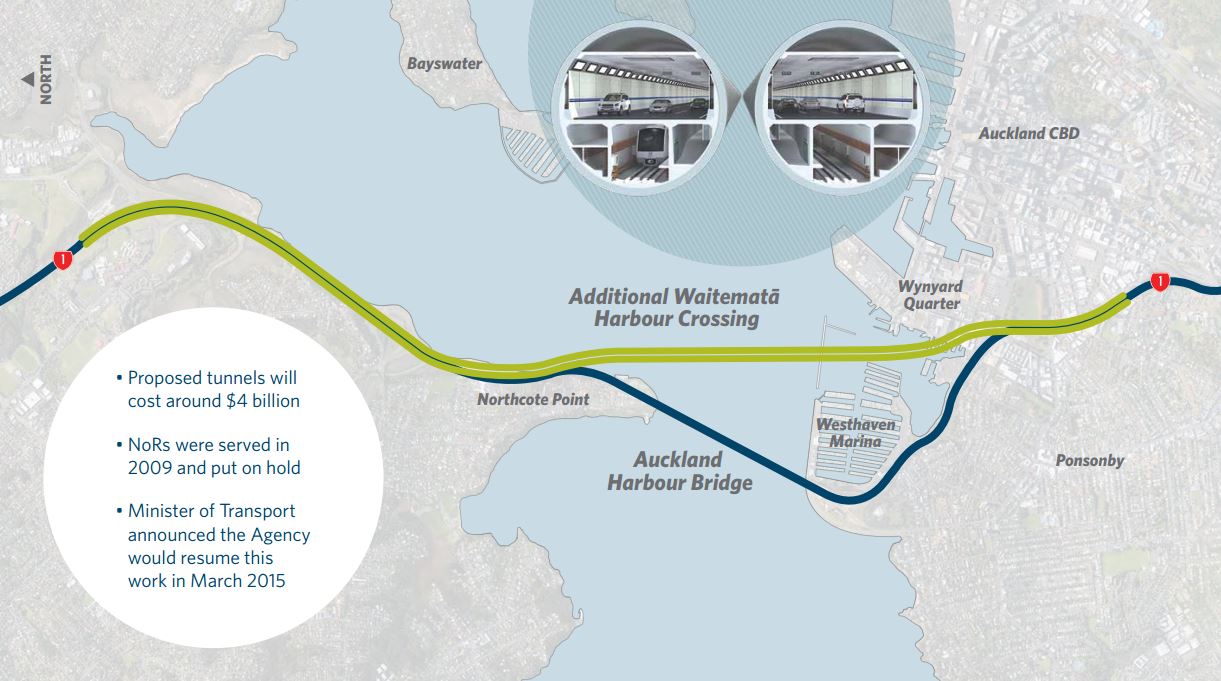
This is something we’ve talked about a number of times before. The most recent plan for another harbour crossing comes from 2011 and in a nutshell, the new crossing would be for traffic travelling past the city centre and the existing Harbour Bridge would become a glorified off-ramp.
There are two logical outcomes from this and neither are good.
1. Stuffs the city and the North Shore
Turning the current Harbour Bridge and approach motorways into an off-ramp only serving city centre trips would be like turning a firehose of traffic on the city centre. That’s because currently, most of the traffic crossing the bridge isn’t heading to the city. Of the approximately 85,000 vehicles that travel southbound daily, only about 25% exit at Fanshawe St (14%) or Cook St (11%). Even if you included Shelly Beach Rd that only adds another 9%. Freeing up so much capacity would encourage people who might currently catch the bus or ferry to return to their cars and that would swamp city centre streets.
This is of course completely at odds with what Auckland has been striving for, although not always as successfully or as fast as we’d like to see. Auckland’s vision is for the city centre to be a more people friendly place, meaning more emphasis put on walking, cycling and urban design and less on moving large metal boxes. That’s much harder to do when at the same time you’re encouraging more people to drive to the city.
The same thing applies on the North Shore, north of where the crossings join. Many of the local roads are already jammed around peak times and this will just exacerbate the problem.
2. Doesn’t add any capacity
In the alternative version, we build the new motorway crossing and in order not to cause the issues mentioned above, we reduce the car capacity on the existing bridge through dedicated bus lanes, bike lanes (perhaps with Skypath dedicated to waking only) or other measures. So in this case we’d be spending $5 billion or more to add no car capacity and only slightly improve buses. This raises the question of why not just use that money to build a dedicated PT crossing?
On top of these two issues there are other things to consider too. For example, the current plans for another crossing have been estimated at more than $5 billion but that is only for the crossing itself between Esmonde and the city. On top of that there would almost certainly need to be a significant widening of the motorway north of Esmonde as far as Constellation – much like how the SH16 causeway was widened as part of Waterview. That won’t come cheap.
Then there is the resilience argument, that having another crossing provides a form of infrastructure security in case something goes wrong. But it’s worth thinking through what this actually means. The current plans have no connection between the bridge and possible tunnel. That means should something happen on either one, the ‘resilience’ option, or even just when maintenance is happening, is to divert all that motorway traffic back through the city centre.
It’s worth noting that the original Auckland Transport Alignment Project (ATAP) report pushed back the timeframe for another road crossing till the 3rd decade (2038-2048) and said this:
Our analysis has shown that in the short and medium term, access to and from the North Shore is not as constrained as for other parts of Auckland (particularly the west and south). While an additional crossing could significantly improve access to/from the North Shore, it does not appear to improve congestion on either side of the crossing.
Forecast growth in freight demand indicates that without a new crossing, some restrictions for heavy vehicles using the Auckland Harbour Bridge may be needed by around 2030 to ensure the longevity of the Harbour Bridge. However, economic analysis showed that the costs of any restrictions are likely to have a minimal impact compared with the costs of a new crossing. Heavy vehicles will continue to be monitored and managed to keep motorists and freight moving across the Auckland Harbour Bridge
Why a PT only crossing is a good idea
While a new road crossing doesn’t make any sense, a dedicated PT crossing does and meets or enables all of the goals stated for why we need a new crossing. Here are a few reasons why
Provides the needed resilience
The need for resilience is the strongest argument for another crossing but that doesn’t have to mean duplicating our existing infrastructure with more of the same. There is also value in providing resilience through having alternatives – we already see almost daily that a crash or breakdown in just the wrong spot can seemingly bring half the motorway and local road network to its knees, same goes for the rail network.
By having a PT only crossing we ensure that not as many people are impacted by disruption on any one mode and that our transport networks complement each other.
One of the best examples of alternatives providing resilience is the 1980 Loma Prieta earthquake in San Francisco. When part of the Bay Bridge collapsed, cutting off an important connection between Oakland and San Francisco, some of the impact was able to be reduced thanks to the BART system which runs under part of the bridge.
Provides the needed capacity
A few years ago, the NZTA provided me with some hourly data on the usage of the Harbour Bridge. From that, I was able to put this graph together showing that traffic volumes peak at 8,000-9,000 vehicles per hour – during which time five of the bridge’s eight lanes are dedicated to the peak direction. 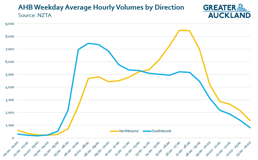
The actual number of people crossing the bridge will be higher than this though as at peak times, 30-40% of people are crossing are doing so on a bus. This would probably put the number up around 11-12k. By comparison, a single light rail line could move almost 11,000 people per hour, essentially doubling the peak hour capacity of the existing bridge.
Aligns with policy
A dedicate PT crossing also fits in best with the current stated goals of Auckland and the government.
The latest version of the Auckland Plan, Auckland’s long term spatial plan, has a section dedicated to transport and access. It includes as one of it’s focus areas to “Make walking, cycling and public transport preferred choices for many more Aucklanders“. The other Directions and Focus Areas would also support a PT crossing.
Then there’s the most recently released version of ATAP that notes more work needs to be done on a future harbour crossing but does suggest there needs to be “flexibility for rapid transit and road to potentially be delivered in separate tunnels at separate times“. In addition, in the section on future Rapid Transit priorities it includes this comment about the Northern Corridor
Projected future demand on this corridor is high and detailed investigation by Auckland Transport suggests upgrading the Northern Busway to a higher capacity mode (likely to be light rail) may be required by the mid-2030s, earlier than previously anticipated. This would require a new rapid transit crossing of the Waitematā Harbour on an alignment that connects with the City-Airport light rail corridor at Wynyard Quarter.
This is also why the combined tunnel, as shown by the NZTA in the first graphic, isn’t a good idea.
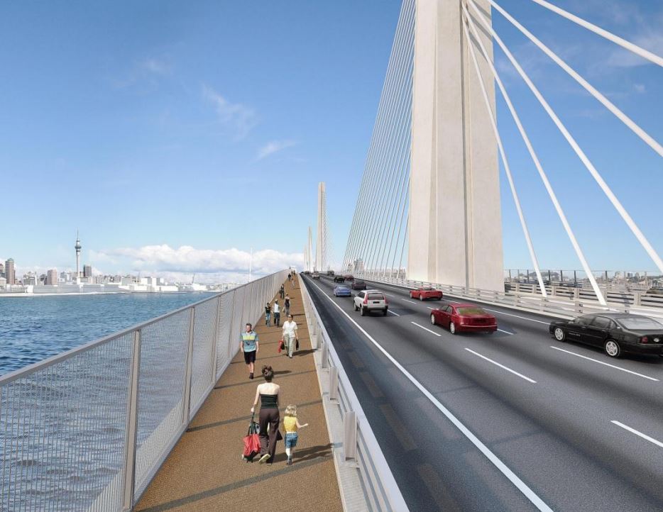
Why a bridge and not a tunnel
It is currently envisioned that any new crossing would be in the form of a tunnel. We also believe the form of any future crossing should be revisited and that bridge would provide a better option.
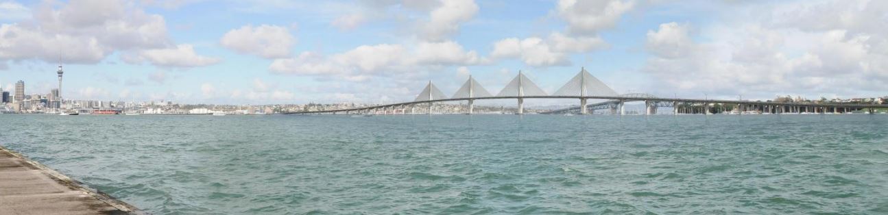
A good example of what we’re thinking about is the Tilikum Crossing in Portland. Opened in 2015, it was built to carry light rail, buses, streetcars, cyclists and pedestrians over the Willamette River. The fact that buses can also use the bridge could be useful here too, if for nothing else than as a staging option until light rail can be extended all the way up the busway.
Here are some of the reasons for that.
Better walking and cycling included
Skypath is a fantastic project and is needed as soon as possible to address 60 years of active mode neglect on the existing bridge. But a PT bridge across the harbour could also include improved walking and cycling facilities – you can never have too many of them. It also wouldn’t make Skypath obsolete as which crossing to use could depend on where you’re coming from, where you’re going to and would depend on where the new bridge landed.
The View
If there’s one thing I never get tired of when commuting home from the North Shore it’s the view of the city that unfolds in-front of you as the bus passes under Esmonde Rd and heads along the edge of Shoal Bay, all the way to the other side of the Harbour. The view is even better from the top floor of a double decker bus.
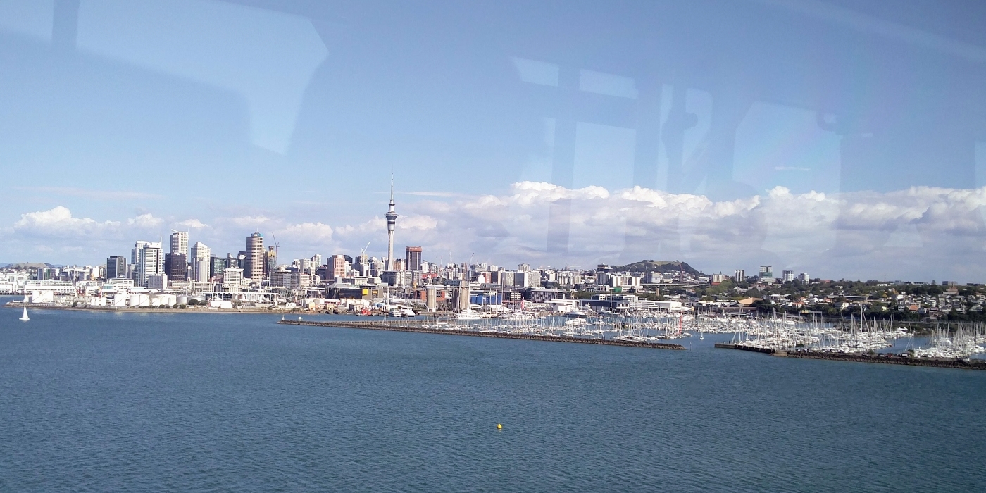
There are probably not too many PT commutes that can compete with that, and sitting on a bus, or future train, actually gives you time to enjoy it. Why would we want to hide that away in a tunnel?
Extra capacity
As mentioned earlier, a single light rail line could carry as many people across the harbour as the current bridge does today. However we believe a bridge also gives us the opportunity to think about providing even more capacity by allowing for up to four tracks as part of the design (two each way). This is something that would require entirely new tunnels to be bored at huge cost if tunnel options were chosen.
Easier to construct
Bridges are easier and faster to construct than tunnels. The last work released publicly for the motorway options showed a bridge taking 1-2 years less time to construct. One of the biggest challenges with the bridge option over a tunnel would likely be to do with consents in and around the harbour, but given the what’s happening with the America’s Cup and that the NZTA didn’t seem too bothered by coastal issues with the East-West Link, this doesn’t seem like it should be too hard for them to address.
The Cost
There’s one final and not insignificant reason to consider a bridge based option, the cost. We don’t know exactly what a PT and active only bridge would cost but it would be:
- cheaper than a motorway bridge, especially on a per capacity basis.
- much cheaper than a tunnel.
Let’s look at each of those quickly.
Compared to a Motorway bridge
A road bridge would be at least six lanes wide, plus the extra space for walking and cycling. The designs created during the last study showed a bridge approximate 47m wide and that included only 3m walking and cycling paths on each side.
By comparison, the Tilikum Crossing is just 23m wide and that includes waking and cycling paths on each side at 4.3m wide. In short, a narrower bridge should also mean a cheaper bridge.
In addition to the width, connecting it into Wynyard should also help make for a cheaper bridge.
Compared to a tunnel
Tunnels are always going to be more expensive than a bridge. As a comparison, in the last AWHC study, the bridge option was estimated to cost $3.9 billion whilst the tunnel option would cost $5.3 billion. So not only did the tunnels cost more, they did less as didn’t include walking and cycling options. We’d expect similar kinds of cost differences between a rail only tunnel or bridge.
We can redefine our harbour
Bridges all over the world are used to define cities and multiple bridges, if designed right, could further enhance Auckland’s. The biggest challenge with this is coming up with the right design as what ever is proposed is going to be hotly debated.

 Processing...
Personally I think a new road bridge should be built as part of a wider statue project, a giant Colossus of an All Black astride the harbour with one foot at Bastion point and the other on top of North head. The road can run up one leg and down the other.
I’ll leave delicate questions of anatomical correctness and small children sailing under the bridge for others to debate.
They could have a pair of pods underneath, one an enclosed viewing platform, and one you can bungy out of. We could dedicate the one you leap out of to Buck Shelford.
I know a ballsack in another design they could borrow, or even better, take.
What about an allblack shooting a fur seal?
Build a bridge but don’t waste money building it so high this time. Give the Westhaven berth holders five years notice to choose which side they want masted yachts to be and then block them in or out. Give the same notice to Chelsea sugar. They can use trucks or bugger off. The new bridge only has to be high enough to get a double level ferry under.
The current bridge was built high to allow access to a port at Pollen Islands which never got off the ground. Don’t waste money a second time.
Yes. Isn’t the navy ships accessing kauri point also an issue? I suggest moving the ammunition storage facilities to Winston Peter’s house up north of whangarei.
Additionally we simply cannot massively expand road capacity like this and claim to be meeting any of our stated climate change targets.
Viewed through this lens, and the explicitly stated plans for the city centre; less, not more traffic, it is frankly extraordinary that NZTA can justify even having half an intern spending any time on pushing a duplicate road crossing.
What century do they think they’re in?
Bbbuuut driverless electric?
Do the math. The planet can not stand replacing every fossil fuel car with a lithium battery one, let alone adding more vehicles to the heap, which a project like this does.
We have to switch more to bigger shared vehicles (like trains) and smaller personal ones (like scooters, bikes etc). And use fewer inefficient (person to vehicle weight and size ratio) vehicles like SUVs, even electric ones.
In cities.
Shared cars? Cute theory; little to zero evidence it occurs in the wild. Irregardless of power source, or number of Apps.
+1
Best (only?) shared car service I know of is the Dolmus (spelling?) used in Istanbul. Great system – large cars, up to 8 people, driving small set routes around back streets. Flag them down anywhere along the way. Also popular runs use small mini-buses.
The dolmus used to use old American cars like 50s Studebakers, now more likely to have a battered old Nissan van or minibus, but it is a good system. Get to meet lots of interesting people.
Ahh, the old American cars used as as a dolmus – sadly now not much in evidence in Istanbul. Great system for a PT service, though. A bit like having Uber drivers run on fixed routes on a “fill up and go” basis. I do recall though that if you tried to board part way along the trip, the chances were that each dolmus was by then full.
Yes, and by extension, adding a PT bridge will have a similar, but smaller effect. It will still induce trips. People switching to PT will leave a gap on the roads for other people to fill. It is less negligent with regard to our carbon commitments, but it is still not responsible. The solution, leaving money for better things, is to convert the existing bridge to PT, active modes and freight.
Hmmm, if Auckland had a static or falling population, yes.
Ah, but think of the mode shift and the urban form changes it would encourage! And there’s nothing wrong with looking at Seattle’s figures again: Seattle grew 21.3% in population since 2006, traffic volumes decreased by 3.3%, and transit ridership increased by 41.8%. Matt says one LR line could take double the current capacity of the bridge. Can we put two LR lines on the bridge each way and quadruple the capacity? How long before we have four times the population? Two LR lines on the bridge should still leave a lane for freight and space for active modes…
Heidi
I will be a hard job to change driving habits on the Shore. I suspect that with a road user charge of say, 5 -$6 road use would change by less than 10%.
I suspect most Shore residents see the need to reduce carbon emissions and hope that someone else is on to it.
I went to a local meeting regarding the Anzac St car park yesterday. One of the proposals was to “future proof” the car park by increasing the number of parks from around 200 to 600. It seemed that no matter the cost, just do it.
If that was the low point then the meeting really plumbed the depths when Councillor Walker said that Takapuna needed a car park because of the money they made. I imagine that he was talking of Wilsons’ car parks.
Ah dear… And AT, I’m sure, were filling their role responsibly as holders of much research, and therefore of key educationalists on the matter…
A question on those AWHC bridge and tunnel costs. I assume they include the various connection tunnels, ramps, interchanges etc etc required to actually connect a crossing to the motorway network north and south of the harbour, which I would expect could be actually more expensive than the crossing itself. Take Waterview as an example, the tunnel is one thing, and the waterview interchange and the widening of SH16 both ways and SH20 to the south is another.
What happens if you just look at just the crossing, how do they compare? That’s probably more relevant to a PT crossing which won’t require anything like the scale of motorway junctions and tie ins.
This is an issue that goes to the heart of the matter. Road projects in congested cities should not be evaluated in isolation, the new traffic they induce have huge ongoing cost implications for the city’s wider driving and parking systems, and beyond.
The cost of Rapid Transit systems on either shore of a crossing has hitherto been considered a deal breaker. But with city-side Light Rail systems terminating downtown to connect to, and the busway available to convert on the Shore, it is the Rapid Transit mode that is easier and more cost effective to connect on land of the two.
High capacity electric Rapid Transit also solves the problem better, efficiently delivering increasing numbers people between the Shore and the city, and fits with all the other external costs of city shaping this century.
Maybe it’s just time to stop with all the fancy kit, and build houses with the money instead.
No Harbour Bridge demand graph has ever been proven right.
The only use the bridge will have for Aucklanders is to give more of them something to sleep under.
Completely off topic, but I’m not sure if GA is aware of this yet (you probably are, as you are all over everything): Current KiwiRail CEO is to take over as CEO of Fletcher Construction, which will mean someone else will be taking the reins at KiwiRail.
“Michele Kernahan became Fletcher Construction’s chief executive after the long-serving Graham Darlow retired, but a surprise announcement on July 16 revealed she is to be replaced by KiwiRail chief executive Peter Reidy.”
https://www.nzherald.co.nz/business/news/article.cfm?c_id=3&objectid=12093583
hmmm Interesting thanks.
The existing super yacht maintenance , refit, and base business is significant to the Auckland and New Zealand economy. This business is heavily dependant on the Western Viaduct berthage and the waterside spar refitting yard adjacent to the current Team New Zealand yard. The size of super yacht masts precludes road transportation and therefore dictates a substantial yard immediately alongside a liftout berth. Such places are rare in the world but they also require a pool of skilled staff. That this exists in here meant that so much of this lucrative super yacht work was retained in Auckland even when the NZ dollar nearly reached parity with the US dollar. A low bridge in the wrong place could be a bridge to far.
No one except Miffy is proposing a low bridge.
They have refurbished masts here that could not pass under the current Auckland Harbour Bridge!
They already do actually, out of the yards in the upper harbour. They simply barge the mast down separately and fit it downtown.
The number of vessels being serviced in Auckland each year that are both large superyachts and sailboats with masts more than 40m above the waterline could be counted on one hand.
Any powerboat superyacht, and any normal keeler that could fit in a berth at westhaven or west harbour could fit under the existing bridge.
Ergo, any new bridge just needs to clear the same height in the main span. Couple that with a handful of superyacht berth on the east side of Wynyard (something they want to do anyway, I believe) and you have no problems.
Of course they could pass under a low bridge. Just not upright.
A high bridge would be a pig for light rail, pedestrians and cyclists. Why on earth should the building of a mast now and then be a constraint on public amenity? Tell them all to bugger off!
Meh, a high bridge would be fine. About 5% grade so big deal for light rail, peds or cycling. It would be like going up Symonds St.
You’d need about 25m for regular sailboats in the marinas anyway, so might as well make it 40m to match the existing bridge.
You don’t need 25m for Westhaven. We need to tell the owners of yachts that it is moving day.
If you want to encourage walking and cycling then one of the worst things you can do is build an artificial hill at either end.
As for the existing bridge, why the hell would anyone want to repeat the mistakes of the past? And don’t bother saying ‘ what about the Newmarket Viaduct’? I know they repeated that mistake by rebuilding it even higher than the first monstrosity, but that doesn’t make it right to keep on doing dumb shit.
Ok, you go tell the combined tenants of the largest marina in the southern hemisphere they all have to move out, and I’ll write your eulogy.
That don’t all have to move out. Only those with a mast. The best part is it can be done without compensation as a launch berth costs the same as a yacht berth.
It isn’t as if the public owe these people anything. For years they have occupied public space and treated it as if it were private property, all the while painting the bottoms of their boats with poison to kill off marine life.
You don’t want to favour fossil-destroying launches over sustainably powered yachts, though, do you? Is an antifouled wind-powered holiday worse than a road slick-creating carbon-producing road trip?
On the other hand, what’s the clearance of the upper harbour bridges anyway? Real Kiwis’ yachts (the ones sailed every couple of weeks by enthusiasts) can get under them fine. Only the sailed-twice-per-year trophy boats would have a problem. 🙂
And then there’s the sweet Chelsea.
Every one has forgotten the 1st bridge that was made to narrow that one is Grafton Bridge . When it was first suggested a couple of the City fathers suggested to make it 4 lanes but they were voted down by the rest saying that Auckland’s population and transport will not get any larger n the future and now look what has happened Buses and ped’s only during the day and the council making heaps fining people
miffy, I’ll take you for a sail on my modest yacht out to Motuhie for a day this summer if you want, we’ll spend the day swimming off the boat, lying under the Pohutakawa trees, watch the stingrays swim up and down the beach in crystal clear water and maybe even crack a cold beer while we enjoy the magic of Auckland.
Sounds good ma. I used to do much the same with my dad on the trailer sailer he built. All without requiring any public space to be privatised. But can you just imagine how great it would be to walk across a low bridge into the city and be able to fish from it and be close to the water while giving a flat walk or ride for people on bikes. It wouldn’t need ridiculous high piers and wouldn’t need to be a blot on the landscape. Why make crossing the harbour an ordeal when it doesn’t need to be just to suit the over-privileged?
It’s very important that any new bridge is navigable by larger vessels, so a low one won’t work. Plus don’t forget the thousands of recreational sailors who actually enjoy taking a sail up the harbour as well as out of it, and the numerous yacht races each week during the summer months. I’d be a fan of one new big all encompassing bridge and get rid of the old one altogether.
There are many reasons a low bridge cannot be built.
However a high bridge will obstruct views from many multi million dollar properties, e.g. from Winston’s house. There would be a lengthy consent process and settlement payments could add up to more than the cost for a tunnel.
A good bridge /is/ the view.
Any consent and settlement process should understand this.
So if they prevented cars from entering the CBD, the harbour bridge would get 25% more capacity. Win/win!
Road network resilience has already been provided by the Waterview tunnel – this was one of the key aims of the project, as per NZTA:
“One of the key aims with the Waterview Connection was to provide a second route through Auckland, bypassing the city centre, and reducing the reliance on State Highway 1 and the Auckland Harbour Bridge.”
https://nzta.govt.nz/media-releases/waterview-connection-proves-its-value-in-first-year-of-operation/
Yep. Shore dwellers want a *3rd* harbour crossing, thanks very much.
Road tunnels also have high operating costs and energy consumption due to all the lighting, fire and air quality equipment they need to meet modern safety standards. Exhaust fumes from oil fueled cars emitting CO2 must be removed, and the pumps and turbines you need to do that for a large mass of air use a lot of power. So if we are serious about reduced CO2 emissions, we should not build more road tunnels.
Yes, we shouldn’t be committing future generations to having to maintain infrastructure with high operating costs. It’s going to be hard enough to maintain what we’ve already got.
I keep hearing about a passenger rail connection to the North Shore and the LR versus HR arguments. Is there any consideration being given to a freight connection? Does anyone care that all freight to the NS is currently trucked over the bridge?
I would be interested to see more about the viability of rail freight in NZ. The ability for freight use seems to often come up in the HR vs LR debate, however I suspect that New urban freight connections are unlikely to be utilized.
Some of New Zealand more recent investments into the freight network, specifically the electrification of the NIMT seem to have produced very low returns, and I worry that any new investment, such as a significant upgrade of the NAL may suffer the same fate.
However I think that this is a sad situation and would love to be proven wrong.
Northland is a little bit different. There are known bulk commodities that have been previously moved by train, namely logs. The reason they are currently moved by road is the port was relocated a number of years ago to Marsden Point where there is no rail. Fixing this will make a big difference.
There are no real freight hubs on the North Shore, the freight going across the bridge will be going to numerous locations. Progressive Enterprises for example are unlikely to put their daily consignment to Countdown Browns Bay on a train only to have to put it on a truck to actually get to the supermarket.
I imagine the gradient of a bridge or tunnel would preclude freight anyway.
The business density would make rail freight unviable.
Or putting it another way, freight needs some really good analysis done, in a framework that understands economic growth as unsustainable, and that measures success in terms of safety, liveability and health.
Yes bridge seems much better value. Do you think it would hit land before the old toll area of the bridge or further up at the Onewa Interchange to allow for a full integrated PT hub/interchange? I guess much like their tunnel plan alignment, earlier it joins the better at Sulphur Beach with that natural curve there.
At the toll plaza, don’t you think: so much space there. Then takes over the buslane to Akoranga for both directions of the LRT. Minimal intrusion on the designation, very little cost at all through the interchange, just needs to leave room for the buses that will still be joining the bridge from Onewa Rd. Otherwise almost no change to the operation of the m’way and bridge… zero disruption to general traffic. Just the conversion of the busway to worry about. How quickly can that be achieved over one summer and how can it be staged…?
NZTA Highway Network Operations should be keen as for such a plan…
I’m sure the AT Strategy team will be biting at the bit to convince NZTA of it.
Agree but except wouldn’t passengers on buses from Onewa Rd way transfer pretty much to the highly frequent LRT transit at the sorely missing interchange around there though? This will also reduce buses into the CBD.
I imagine they wouldn’t transfer to go to the city centre, but would transfer to go the other way to takapuna or albany.
I’ve made a map of the potential bridge orientation, including Onewa transport hub: https://goo.gl/zu627v
And because NZTA would never approve it without allowing space for their precious road tunnel, I’ve shown that alignment as well (fingers crossed it’s never built).
Graeme, On your proposed bridge alignment where are the launch points? That where does the alignment meet ground level at each end. I would have thought at the southern end it would be preferable that the LR route was via Fanshaw street rather then Victoria St West. I think I am not alone in questioning the acceptability of a viaduct rising to a considerable height complete with the inevitable undesirable under bridge areas between the support pylons. This along a prime axis of the Wynyard quarter. I also suspect though, that that would be required for anything other then Miffy Bridge at low level.
A double track LR tunnel entrance would instead have a minor effect on either Daldy or Beaumont Street.
Hi Don
Good point, it would be preferable if the bridge rose along Beaumont St rather than Daldy St. This would allow marine businesses to operate on the western edge, with a good division from the apartments & regeneration in the centre and east. I’ve updated the map with that concept.
I don’t have any idea of the rise needed, but I’d think tall ships can head further out into the channel to pass underneath.
I had used Daldy because that’s the current plan for the Light Rail terminus.
Why would there be a viaduct at all? Start the bridge at the end of the Wynyard Quarter at ground level, and rise above the water. 5% grade, 1800m total length, starting 2m above sea level gives you a nominal 47m clearance at the midpoint.
Consider this LRT bridge being built in Helsinki. Sure it is a little shorter and only has some 20m clearance, but it just ramps up from ground level without and viaducts or anything:
http://mb.cision.com/Public/50/9430447/bb028a48c16c8964_800x800ar.jpg
Excellent article Matt. I agree on all your points and all your reasons!
Agreed.
How about just replacing that god-awful coat-hanger bridge and building a more aesthetically appealing bridge with everything required? 8 lanes of motorway (or 6 if you can get away with it), 2-4 lanes of busway/light rail (future line to Takapuna?), 2 cycle lanes, 1 walking lane.
JBM: don’t kill the goose that laid the golden egg! One bridge over the waitamata is bad enough. Please don’t build more! Tamale Makaurau is one of the most beautiful geography in the world let’s not fuck it over with more bridges & spoil our enjoyment of it. Better still remove all the bridges & replace with one big tunnel.
Personally, I think two bridges not running parallel to each other will look butt-ugly on the harbor, but that is about my only issue.
All the rest of the proposition seems sound…
The Forth bridges aren’t exactly parallel (https://goo.gl/G4xJnG) and they look pretty impressive!
The bigger eyesore are the huge motorway plazas leading up to multiple crossings (e.g. North Sydney https://goo.gl/vYVw6F).
I am pro bridge. But I do think the bridge should be future proofed for up to 6 motor way lanes.
Maybe the extra lanes could be fixed under the upper lanes to make a double decked cable stay bridge, I don’t think there are any double decker cable stay bridges in the world yet.
If we can avoid building tunnels for over 100 years, that will be great.
As for height I think our current eye sore bridge has about 40 metres clearance. I would say 30 metres for the new one is sufficient.
Not to mention the new bridge could be 1 and half times the total length of our current bridge, that leaves more room for gradient.
John, have you thought through where all that extra traffic would go? Getting people across the harbour is one thing, but why do they have to take their big metal boxes with them?
“Future proofing’ a bridge for six motorway lanes means just building six motorway lanes. Which would make the bridge four times wider than it needs to be (eight vehicle lanes instead of two), which makes it maybe four times more massive and certainly far more expensive.
The best future proofing is to build a slim, cheap and efficient transit crossing now, then consider if you need a separate road crossing in the future.
It would be far, far cheaper to build a two lane crossing now and a six lane one in fifteen years than it would be to build an eight lane one now.
JohnM
Yes 6 motorway lanes and as part of future proofing and resilience maybe it could be configured to allow planes to land if the airport is fogged in?
We have only 47 years’ oil supply left – at current consumption rates. The days of the internal combustion engine are numbered – be it car, bus, motorbike or lawnmower. Of the energy source options to replace it we have – currently – Electric, Nuclear, Natural Gas, or Solar. I’d pick electric.
They are already in use: Taxis in China. Autonomous Vehicles for Google Street View. There are already recharge stops. By the time any sort of crossing is built – knowing the Auckland disease – 47 years will have elapsed, and traffic will cease to be an issue owing to Deep Learning models & integration with the GPS grid:
https://www.youtube.com/watch?v=Afksjd9WhUY
Most interested in the opinions expressed in Greater Auckland and am very keen to hear more and be better informed.