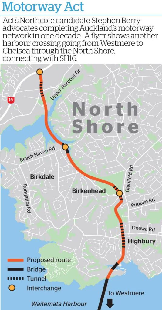
ACT’s candidate for the Northcote byelection, Stephen Berry, may not have won but caused quite a bit of discussion with his rather crazy motorway plan that we first discussed a few weeks ago. It would have cut a gigantic swathe through the green spaces of the electorate that he supposedly wanted to represent. Simon Wilson also covers the proposal in quite a bit of detail here.
Source: NZHerald
In terms of its likely cost, environmental and social impact, the project is obviously a non-starter. Putting those issues aside though, it probably would be reasonably effective in drawing traffic away from State Highway 1. Assuming it was also somehow linked into State Highway 20, it would also ease some pressure on spaghetti junction, although SH16 from Pt Chevalier into town might become unbearably congested. So, billions of dollars and a path of destruction across the North Shore and inner west, but at least it would “make a difference”.
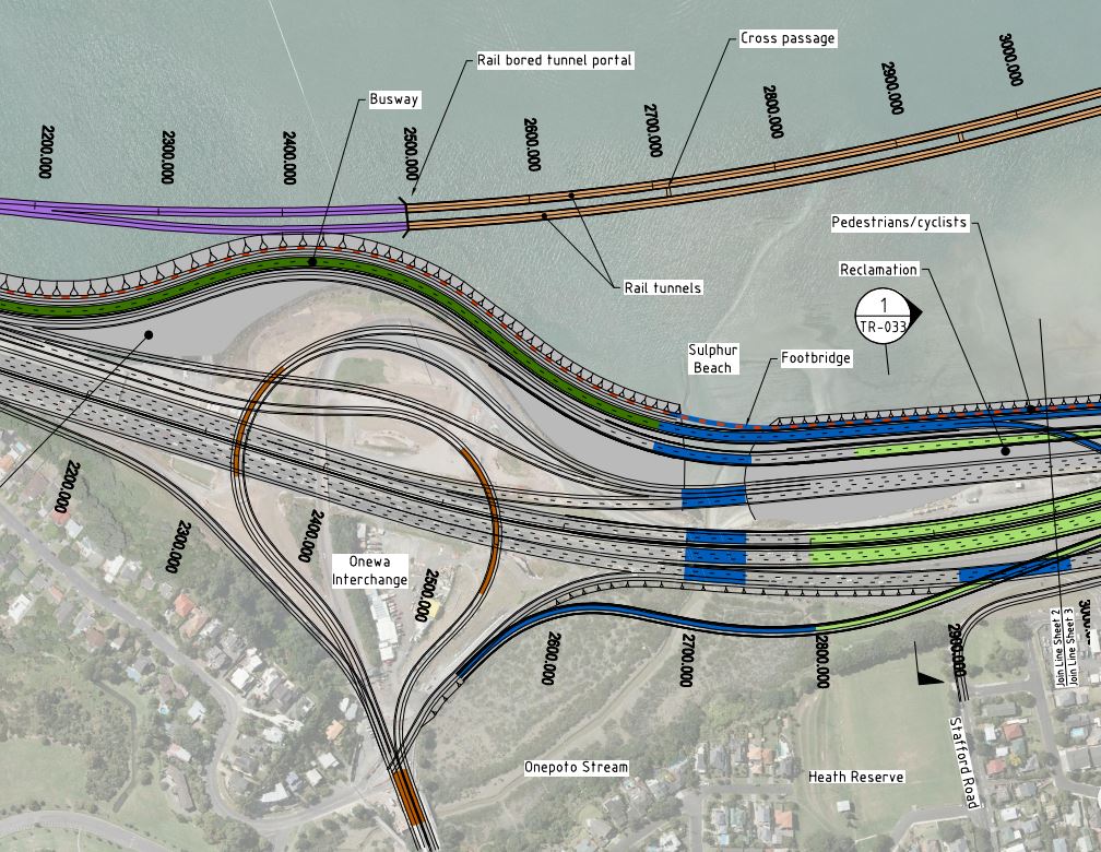
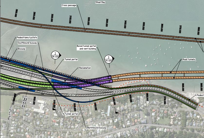
This got me thinking once again about NZTA’s actual current proposal for an additional roading link across the Waitemata Harbour. We have discussed this project many times over the past few years, with the general flavour of those posts being along the lines of this being the stupidest project ever. The map below shows what’s proposed:

In a nutshell, through-traffic (i.e. vehicles not travelling to Shelly Beach Road or the city) would use the new tunnel and the existing harbour bridge would effectively become a huge off-ramp. The two motorways would merge by Esmonde Road in the north.
While the impact of this proposal (especially if it’s a tunnel) would obviously be nowhere near the scale of Stephen Berry’s proposal, the effects are still massive. Just look at all that required reclamation around the Onewa Road interchange (all maps from here):
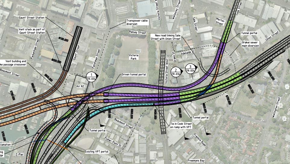
And check out the maze of cut and cover tunnels underneath Victoria Park. Almost certainly that’s going to impact on the amazing trees that go around the edge of that awesome inner-city park:
Even without the separate rail tunnel, we are looking at a project that in 2010 was estimated to cost around $5.3 billion (the rail tunnels were estimated at a comparatively cheap $1.6 billion). Just as an aside, I’m pretty sure in 2010 City Rail Link’s cost was projected to be less than $2 billion, so I’d hate to think what an updated cost estimate for the harbour crossing project might be. The cost also doesn’t include any widening of SH1 north of Esmonde Rd. That is likely to be needed as far as at least Constellation Dr and could add up to an extra billion dollars.
So NZTA’s plans are for something that will be enormously destructive and hugely expensive. But, amazingly, that’s not the worst of it. The actual worst things about this project are:
- The huge increase in traffic on local streets from the project, especially those linking with the on and off ramps and in the city centre, where we are trying to reduce traffic numbers to create a more liveable city.
- The fact that the project actually doesn’t even help reduce congestion.
Starting first with the traffic on local streets, even NZTA’s own specialist report makes a fairly brutal conclusion:
Some of the increases in local road traffic volumes are pretty massive. Just look at what it does to Cook Street, for example:

The alternative to flooding the city with even more cars would be to reduce the number of lanes on the harbour bridge, such as using the space for bus lanes. So essentially spending billions for a couple of bus lanes when we could use that same money to create a crossing and an entire rapid transit network for the North Shore.
Turning next to what impact the project actually has on congestion, the results of modelling undertaken as part of ATAP in 2016 were pretty dismal. The multi-billion dollar hugely destructive new motorway link actually ended up being just as congested as the Harbour Bridge would be without the project, while the central motorway junction ended up much more congested! Therefore the only real beneficiaries would be those driving between the North Shore and the City Centre – hardly the trips we would want to encourage to move from PT to car!

So let’s summarise this. NZTA’s official project:
- Creates huge environmental destruction through massive reclamation around Northcote Point and would essentially destroy part of Victoria Park, at least during construction.
- Undermines everything Auckland is trying to achieve in its city centre by encouraging more car trips into this constrained space.
- Was estimated to cost $5.3 billion in 2010, noting that other large projects have nearly doubled in cost since 2010.
- Doesn’t actually reduce congestion for those travelling past the city centre.
There’s one bit of salt for the wound. The 2010 version of the crossing showed rail tunnels separate from the motorway ones, the latest thinking is to combine them, as shown in the second diagram. The problem though, as I understand it, is no consideration has been given as to how the rail lines in those tunnels would then connect to the city or if that connection ties in with how Auckland’s rapid transit network is evolving. So while the NZTA will claim the benefit of including a rail crossing in their evaluations, it’s not necessarily a rail crossing we may be able to take advantage of, at least not easily.
Stephen Berry’s harbour crossing idea may be crazy. But NZTA’s official one, that they have spent well over a decade and many millions of dollars working on, isn’t much better at all.

 Processing...
Stephen Berry’s one might actually be better. If it connects just with SH20 and not SH16 (except to/from the northwest) it could form an effective bypass of the CBD/spaghetti junction and really reduce pressure on SH1 and spaghetti junction without all the negative effects of the NZTA proposal. And if you factor in the widening of SH1 north of Takapuna to accommodate the NZTA crossing a version of Stephen Berry’s as a smaller 4 land highway and using more tunneling might actually be cheaper
Or just build neither of them.
Given the tight SH16 ramp spacing it pretty much has to connect at either the St Lukes or Gt Nth Rd interchange. This puts the route either through the zoo & western springs, or right through the middle of Pt Chev. I’d think a tunnel under Pt Chev is likely the only buildable option. Linking this into SH20 directly would require restricting traffic from SH18 so as not to overload the tunnel traffic lanes. It would need to be able to connect with SH18 as well requiring an additional mess of ramps.
Given these constraints and those through spaghetti junction grafton gully might be a better target for an alternative vehicle crossing.
Why even give any of these car mode (ie space inefficient and hugely costly) options the time of day? We can’t take the environmental, social and health impact they’ll impose on us. We can’t cope with the extra traffic. And we most certainly can’t afford them.
because that is what most of the public want
Could you back that up, please? It certainly runs counter to every measure I’ve seen.
What the public wants – Only if it’s considered to be ‘free’. If the mainstream media actually posted the true costings of these sort of projects then I’m sure ‘most of the public’ would say “F*&k no!”
01anthony, can you please provide evidence of the numbers you talk about? If the mainstream media dont link to them why dont you
Beachaven to SH20, even if it’s via 50km/hr bridge would be a lifesaver, it would bring a large chunk of people much more connected, and give an alternate path, I always thought that another harbor crossing was all about bypassing the spaghetti junction, doubling up the existing route doesn’t help. If we have learnt anything from IT, is that redundancy is good, but it does need to be redundant.
How about Beach Haven to SH18? A bridge across to the motorway at Greenhithe.
That’s a lot more feasible and effective.
I did mean SH18 🙂 Woops
It’s time Twyford killed this horrific project for good.
With respect, Twyford can only “kill” this project for two and a half years, or less.
I reckon he has about eight and a half years.
With the new government at the reins, hopefully more pressure can be put onto NZTA (who are now leading the Auckland LRT project) to diverting their attention from filling Auckland city up with more cars and focusing
on moving people instead.
The success of the Northern Busway and NEX service is pointing towards better public transport instead of better vehicle capacity. All we need crossing the harbour (other than the Harbour Bridge) is a public transport connection that can provide rail to the shore.
Wow, so $5.3b dollars (in 2010, so let’s call it $8b) that only achieves 20,000 extra cars into the City Centre each day…. right when we are trying to decongest the city centre of traffic.
Hmmm, so 20k cars, that’s at best 25k people… putting aside the fact we don’t have or want widened city streets to drive them on, that’s another 20k car parks needed. So where exactly do we put another six downtown carparking buildings? Did they work that into the cost benefit analysis?
But wait, 25k people, that’s what a half decent rail crossing could move in a two hour peak. So we just build the rail crossing for a third of the cost, and we move all the same people to the same place, but without a single extra parking building needed and no increase in congestion or traffic volumes at all?
Higher benefits for a third the cost, sounds like a better idea to me.
The only rational plan from here is a new Rapid Transit rail crossing and associated network on the Shore. It is only habit and path dependency that has NZTA putting resources into anything else for this route. They’ll eventually shake out of their road only psychosis with enough encouragement from above.
There are still plenty of questions for them answer:
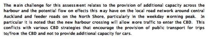
1) Do we flip the coming Light Rail from Wynyard across the Harbour and up the Busway (and Takapuna) as we propose in the CFN? Very elegant and economically efficient solution.
2) Will that have enough capacity? We calculated it would; as it takes the volume from both city-side lines, the Northwest and the Isthmus+Mangere. So the two lines would be interlined between Akoranga and K Rd; double the capacity here.
3) Or should it be separate higher capacity system? Though that would add cost of a new solution cityside.
4) If LR, please lets reconsider a new bridge (LR can deal with the gradient to allow vessels below) would be cheaper, and a new beautiful bridge gracing the harbour, and concealing the old ugly one would be great, IMO. And could add great walking and cycling too…
Do you really think that the Queen Street/Fanshaw Street light rail corridor will have enough capacity for the Northern Line and the Takapuna Line?
I think that it will be necessary to run both lines at 12tph in the future. That is 24tph combined and 48th in total. I don’t think that the Custom St-Queen St or Fanshaw-Nelson St intersections could provide signal preemption every 1.25 minutes. Either these intersections will have to be grade separated, which would be expensive and ugly, or the light rail vehicles will need to stop and wait for their turn in the traffic phase.
I think that a much more appropriate solution would be a second platform at Aotea Station under Wellesley St. The only issue with this solution is where to send the LRV’s after they reach Aotea. If they terminate at Aotea a larger station footprint will be required. Otherwise the tunnels would need to continue to a terminus elsewhere.
One final advantage of an underground link from Wynyard to Aotea is that longer trains could be run on the Northern Line as there would be no street running sections.
Yes I do. Those intersections run thousands of vehicles on two minute cycles as it is. So 24tph is one vehicle every signal cycle or two.
The customs one becomes hardly an intersection at all, just one traffic phase and one rail cross phase.
There is no need to build a three billion dollar underground link when you can use Queen.
Oh and you can have longer trains anyway, there is no particular reason why they have to be limited to 66m. Or street blocks are all 100 to 200m minimum.
For example both Dallas and Seattle have road corridor stops in their city centre that are 120m long.
But Sam W is arguing that it’s 48tph if you looking at both directions in total with the NW & southern lines. If I understand it correctly – and this will clarify my thinking here: A 2min light cycle mean (not counting orange phase) 1 min for the straight ahead general traffic along Customs west or east direction (no turns as assume traffic free on Queen) & 1min for the LRT going right into Queen or left out from Queen. That means unless the LR vehicles happen to arrive at the same time from both directions they will be waiting often for say up to a minute, then another may arrive behind and we could easily end up with queuing & bunching unless we punish the general traffic phase.
Then we have the other intersections & crossing right into & out of Wynyard.
I guess if there is going to be capacity constraints, short of banning more traffic, grade separations could be done. Sounds awkward and expensive.
As I’ve kicked around before, I keep thinking that maybe NW LRT really needs to eventually have it’s own corridor into the city once any North Shore line is also added into the Queen St corridor. You could split the NW line between an Ian McKinnon/Queen St & a slower one up Newton Rd area & onto Albert St. This could have a great link to Beresford Square CRL station, it could terminate at lower Albert St rather than have to cross over to Wynyard & to the shore.
Yep so let’s run with that as a strawman, assuming random arrivals.
So in each direction, for one minute (50% of the cycle) the LRT can run straight through without even slowing down. For the other 50% of the cycle it will have to wait, for up to one minute at worst and for 30 seconds on average.
(actually there’s a bit of null phase between red and green, but close enough)
Average that all out and you have half not stopping, half stopping. Of the ones that do stop, average stop time is 30 seconds. Total average wait time is 15 seconds.
If we look at the LRT in the Gold Coast, they actually have dwell times under 30 seconds at times. So even with a stop right after the intersection you can conceivably get two through inside a minute.
So basically you should be able to comfortably clear an LRV through the intersection each way once per two minute cycle. 24 tph is one vehicle every two and a half minutes, so one a little less than one per cycle.
Of course that is if we stick with existing two minute cycle times. We could re signal for 90 seconds (given it’s really only two phases) and reduce the chance of bunching further.
Grade separation might be an option in the long long term, but I don’t see it.
As for a second corridor, maybe that’s the approach provided the two don’t intersect at all. Spllitting or merging lines through two different legs of an intersection will have less capacity that running more frequency through one leg.
Nick R, how many on-street LRT systems with vehicles of more-than old-style street-tram length, do you know that run at a frequency greater than 12 tph? Very few I would say.
Here is a quick survey of a few systems I did back in 2011:
. . City. . . . . Max tph. . . . .Max veh len/m. . . .Design pphpd
Calgary . . . . . . .12. . . . . . . . . . .74. . . . . . . . . . 5832
Phoenix. . . . . . . .5 . . . . . . . . . .84. . . . . . . . . . 2625
Dallas . . . . . . . .18. . . . . . . . . . .85/113*. . . . . . 8640/10,800*
Houston. . . . . . .10. . . . . . . . . . 58/93* . . . . . . . <4000/??*
San Diego. . . . . .8. . . . . . . . . . .56. . . . . . . . . . 2944
Portland (y+g). . .8. . . . . . . . . . .58. . . . . . . . . . 2752
Portland (r+b). . 12. . . . . . . . . . .58. . . . . . . . . . 4128
Nottingham . . . .12. . . . . . . . . . .33. . . . . . . . . . 2922
Manchester . . . .15. . . . . . . . . . 57. . . . . . . . . . 6000
Gold Coast . . . . .8. . . . . . . . . . .43. . . . . . . . . . 2472
* denotes planned increase (which may have happened by now)
Note also: Karlsruhe with a frequency of perhaps 60tph of mainly shorter-length trams has now seen fit to put them underground through the CBD
So although 24tph at 66m (or 132m) is theoretically possible, it is not remotely approached by most of the above systems. And for those operations than run at in excess of about 5,000pphpd, the "streets" that they run in tend to resemble tram-canyons rather than pedestrian areas. E.g. Pacific Ave, Dallas: https://www.google.co.nz/maps/@32.7817049,-96.8009418,3a,75y,95.46h,92.18t/data=!3m6!1e1!3m4!1sHPi5X0jCHlP5FynBw0_Z_g!2e0!7i13312!8i6656?hl=en
If you know of any systems (outside of the 3rd world) that provide significantly more capacity down a single pedestrian street than say Dallas does, then I would be very interested to know.
I think a dose of realism is needed before touting on-street LRT with very high-end capacities.
That’s an interesting list Dave B, but you are simply listing what they did run (or planned to run) seven years ago. That’s a lot different from what they plan to run in the future, and what they can run.
For example, the gold coast operating manual lists the minimum headway as 3 minutes, or 20 trains per hour. And even then that is a ‘balanced’ limit based on what works with the existing signals, to avoid disrupting traffic.
If they wanted to resignal to actually prioritise the LRT they could do more. The same manual lists a 2 minute headway as the minimum to avoid bunching, i.e. 30 trains an hour.
http://www.goldlinq.com.au/resources/chapter-7-operations-4cd892b2.pdf (section 3.2.1)
So actually the “design pphpd” should be 6,180 for the Gold Coast if you take the ‘balanced with traffic’ limit, or 9,270 if you take the ‘avoid bunching’ limit.
I haven’t looked up operating plans for all the other systems, but a quick google suggest some of your figures seem off or out of date.
Portland for example runs 18tph from the Blue, Red and Green lines every morning on Holladay Street from the Floyd Center to the Steel Bridge. That’s a street level section of corridor that fuctionally very similar to what Queen St will be, and pleasant looking (by the way the canyon effect is a quality of the buildings and the street, not the vehicles that run on it. Dallas is full of ‘car canyons’ also). And again that is what they do run today, not what the capacity is or what they run in the future.
So indeed a dose or realism, you’ve provided plenty of evidence that many LRT systems run very long vehicles (over 100m in cases) very frequently (18tph or more) in urban, street level corridors, providing capacity for at least eight or ten thousand people per hour each way. This is excellent, thanks.
@Nick R, Sounds like the frequency of LR vehicles though that intersection is quite doable then, can see that working thanks. If needed the traffic options on Daldy St could be simplified to make crossing that fine as well.
Yes Nick R, you are right that my table lists how the systems currently run (or how they ran back in 2011 when I collected this data), not what they are theoretically capable of.
Maybe we will see frequencies of 24tph running through Queen-Street-type environments one day, but I have not yet seen it anywhere myself, or at least not with predominantly large high-capacity LRV’s which take up more lane-metres and take longer to clear than shorter trams.
2½-min spacings in both directions may not afford much tram-free time around busy stops once dwell-times and vehicle-length clearance times to/from rest have eaten into this.
I did notice that the sheer intensity of trams in Karlsruhe’s tram-only Kaiserstrasse was bordering on oppressive, but as I said they have undergrounded them now or are in the process of doing so. In contrast, Stuttgart undergrounded its LRT beneath Kõnigstrasse many years ago and this showpiece street is now a peaceful pedestrian precinct with rapid transit underneath, fully conflict-free. The Germans clearly decided there was a limit to how much tram-traffic the street could tolerate.
I watch with interest to see which city is bold enough to unleash 24tph in-the-street, to fit the theory!
Err, well our city is bold enough to unleash 800vphpd on Queen Street today, so I think we can manage scaling that back massively to a mere 24.
@ Nick R “800vphpd on Queen Street today”
Where do you get that figure from? If true, that can only be the momentary flow-rate as very busy times. 800 vehicles per hour per direction represents one vehicle each way every 4.5 seconds, assuming no gaps for red phases. You’d never get across!
Matt L produced a chart showing peak traffic volumes in Queen Street (2016) at around 300vphpd – http://www.greaterauckland.org.nz/wp-content/uploads/2016/04/Queen-St-volumes-Traffic-by-hour-2.jpg
(Possibly they may have reached 800/hr back in 2004, when apparently there were 10,000/day)
But just consider that a 66m tram occupies the same road length as 12 x 4.5m cars stacked 1m apart. So one could say that 24 trams per hour equate to 288 cars per hour – i.e.not far off what Matt’s chart says Queen Street has now! Ha ha, I know this is a nonsensical comparison and not very meaningful at all, but I think your comparison of 24 trams per hour with 800 vehicles per hour is also pretty misleading.
24x 66m trams per hour each way will be well beyond what any cities that I know of currently shove down a single street.
800vph was a rule of thumb for capacity of a lane of arterial traffic. It’s about two dozen cars per cycle. Yeah, might be over egging it for Queen St, I don’t know the actually counts.
Obviously it’s not a car every four seconds, it’s a bunch of cars with every phase, separated by gaps of a few seconds and limited by a pedestrian crossings every two minutes.
But regardless, 24 vehicles an hour is far, far fewer vehicles on the street. Instead of a constant pulse of cars with a crossing phase every two minutes it will be the opposite: a constant lack of vehicles, with one (admittedly large) vehicle passing for a few seconds every few minutes.
If you don’t believe me go down there with a stop watch, observed the traffic and peds, the phases. Time the gaps. Then imagine no traffic and count out 75 seconds, that’s how long you’ll have without a single vehicle passing even at the full headway in both directions.
Central Melbourne (Hoddle Grid) has mostly 90 second, 2-part traffic light cycles. Swanston St carries a peak load of about 40 trams each way per hour – mostly one per cycle, occasionally two or none. Trams are between 15m and 33m long.
In this scenario, the length of the tram is not an important constraint, within the likely range. For example, a tram starting from the stop line, accelerating at 1 metre per second per second to let’s say 12 metres per second (about 43kph) crossing a street 20m wide, would completely clear the intersection in:
– if the tram is 20m long: about 9 seconds
– if the tram is 40m long: about 11 seconds
– if the tram is 60m long: about 13 seconds
and so on. All of which are small numbers in context of 40 seconds of green time per cycle.
In other words, the main constraint on capacity comes from the number of traffic light cycles per hour, not the length of the trams (assuming you want to plan for no more than one tram per cycle to avoid bunching).
Interesting. On Queen St they won’t be 40 seconds of green time per cycle. NZTA recommends that pedestrian wait times should never be more than 30 seconds in urban areas. What are they on Queen St? I’d imagine they’d be aiming for less than 30 seconds, which still feels a long time. I’m not sure what else you need to factor in. Does the tram length start to be of concern if the pedestrian wait time is only 22 seconds, say?
On Queen St there should be constant alternating green phases for pedestrians. With LRT going north-south pedestrains can cross north-south at the same time, then with cross traffic and buses going east-west pedestrains can cross east west. Then it flicks back to north-south, then back to east-west, etc etc all day long.
That should be far improved over the status quo.
To clarify: the 90-second, two part cycle means, for traffic: 40 seconds green, 5 seconds orange, 45 seconds red. For pedestrians: about 20-25 seconds green man, 20-25 seconds flashing red man (as required considering the width of the streets), 45 seconds red man.
Right turning traffic does hook turns from the left lane; left turning traffic filters through the pedestrians it’s turning across (who of course have priority on the green man).
Insisting on three and four part cycles with separate turning phases is what really kills the pedestrian amenity, as it greatly reduces the possible green man time in proportion to total cycle time.
So then the 45 seconds of red light time plus say 20 seconds when you shouldn’t start because it’s a flashing red, that’s over a minute of wait time! On paper, that’s excessively long for Queen St. Is that really what they’re planning? The linear park will have a 1 minute 5 wait time at Queen St when even NZTA says that no urban area should have a wait time longer than 30 seconds?
Crossing distances and the red man phase will be much smaller, there will only be two lanes to cross.
So what do you think the phasing will be, Nick? And will it allow wait times of no more than 30 seconds?
With two lanes each, it should only take 9 seconds to cross either Queen St or the cross streets (7m @ 1.2m/s)
My view is the cycle should be 60 seconds, alternating between two phases.
So it would be something like:
N-S 19 sec green man, 9 sec flashing, 2 seconds null (LRVs have 28 sec to cross intersection)
E-W 19 sec green man, 9 sec flashing, 2 seconds null (buses/cross traffic have 24 sec green, 4 sec orange).
So maximum wait time would be 30 seconds at the absolute worst to cross one way where you arrive exactly as the flashing man starts.
But note that if you are going to cross diagonally you have the option of doing either leg first, then the following one. So you can go with whichever one is green. In that case the worst you’d wait is 9+2 seconds to start.
Also note I’m talking about 60 seconds here, so the whole thing would cycle two or three times in the amount of time it currently takes to do one cycle.
Just my thoughts, I’m not a signal engineer so might have got something really wrong here.
Thanks, Nick. Looks good.
Agreed. Sounds do-able.
@ John Smith
Yes, Melbourne’s Swanston Street looks to have a very high intensity of trams. The world’s busiest tram thoroughfare according to Wikipedia. Do you know if this works OK, or is there pressure to reduce tram numbers?
Is the proposed metro tunnel under Swanston Street expected or intended to reduce the volume of tram traffic? Would be interested to know.
Swanston St works ok, it has platforms that are long enough for two to four trams at a time (the fleet are various lengths) and at busiest they platoon along in bunches of two or sometimes three. Like Smith says above, you get a tram or a bunch on each green light.
Queen St as proposed would be the same, except it would be one large LRV rather than a bunch, and even at busiest it would be one every second light, more or less.
There have been some tweaks to route one line via other city corridors, but basically they have dedicated Swanston St to be a tram and bike corridor and intend to keep it very busy. Swanston St is the centre of the CBD, links two main train stations and serves two universities… so people want to be on that corridor.
Melbourne Metro links existing train lines in the northeast and southwest, it’s more about taking lines out of the City Loop and running more trains overall, than relieving the trams. But personally I think adding the train station at the university will have a big effect on crowding, thousands of students catch the train into town and hop on the swanson st corridor (at the most crowded point) for the last couple of km to the campus.
LR running on the busway corridor does seem the most practical option the short to medium term. Eventually, however, the Shore may need more capacity and we’ll have wrung as much out of the existing rail network as we can. If we get go this point then CRL2 is probably our best bet and we should ensure that it supplements rather than replaces or duplicates NSLR.
“Wow, so $5.3b dollars”. Yes but they could probably do it for significantly less if they don’t build all those big black numbers in the sea.
You’d get rid of those pontoons? That’s the only fun part of the plan.
Well at least halve their size by not building the decimal point and zeros. Do they really need to clutter the estuarine environment with numbers accurate to 1/2 a millimetre?
You noticed how smoggy the air is? Surely that would’ve put them off the idea … or maybe they need to redo the modelling with better EV uptake. 🙂
So what’s your reward for making your daily dad joke target
You don’t find it faintly ridiculous that someone draw a plan of a civil engineering project and labelled the chainage to 3 decimal places? I mean are they expecting this to be built to 0.5mm tolerances. And someone else checked it. Any ridicule they get is well earned.
“…no consideration has been given as to how the rail lines in those tunnels would then connect to the city or if that connection ties in with how Auckland’s rapid transit network is evolving.”
In a post elsewhere, I tried to point out that a very good connection would be to bring the rail tunnel under Victoria Park and then, while still underground, turn it to the east, broadly following Cook Street. The connection would be made underground to the CRL, a little to the south of Aotea Station, in the vicinity of the Police station.
A north going and a south going connection could be made there, allowing services between the Shore and 1. Britomart via Aotea Station, and 2. Mount Eden via Karangahape Station and thence to the south and west. If one looks at the path of the CRL in the vicinity of Cook Street and the Police station, one sees two doglegs which are at exactly the correct angles for this north-south Tee connection.
Please take this seriously. This underground connection to the CRL is much more versatile than a northern rail connection to Britomart.
Why wouldn’t you bring it along under Wellesley St so that it actually connects with Aotea Station rather than being a block away. Aotea Station has been designed so another perpendicular line can go underneath it.
Two things. The eastbound turn might be too tight to connect with Aotea Station and a connection a little further south allows a wider turn. A Tee connection at a station? Can that actually work without being complex in an underground station?
I can’t see how the turn would be any tighter than the one out of Britomart and up Albert St on the CRL. Seems crazy to spend billions on rail tunneling only to have the stations not line up.
Why would you want to push a new set of tracks into the CRL? The CRL only has so much capacity, if you stick a northern line into the side of it it still only has so much capacity.
Better to keep the northern line separate with a passenger connection at Aotea, that way you have double the capacity.
Not sticking another line onto it. Your thinking is that of a terminal station system. Don’t you understand that a North Shore Line joining the CRL between Aotea and Karangahape doesn’t turn back again at Britomart. It continues on and becomes an Eastern or Southern Line service. Services departing from Shore stations would display “Manukau via Britomart”, or “Swanson via Mount Eden”.
Right so eastern line trains don’t go to Aotea and western line trains don’t go to Britoamrt?
Ok that’s those two patterns, what about the other two other existing ones? Where do the Papakura and Onehunga trains run… still in the CRL right?
Eastern Line trains go via Britomart and Aotea to either the North Shore or via Karangahape to Mt Eden and the west. Papakura and Onehunga trains… the same.
The proposal for the CRL has 12tph from the Western line and 18th from the Eastern line entering the CRL in the morning peak so that is 30tph heading to the North Shore, that is going to require a pretty elaborate underground flying junction.
As Nick said, seems crazy to have some lines skipping the busiest station.
What station will be skipped?
I really think you two haven’t thought about my proposal at all. In fact, I can’t understand what you’re driving at.
Nick, some services from Manukau and some from Papakura would stop at Britomart then continue on through Aotea, then go to the Shore. Others wouldn’t turn off to the Shore but would continue on via Karangahape to Mt Eden and the west.
Look at it this way, only Swanson, Papakura and Manukau will be terminating stations. All of the rest will be through stations with flexibility about where trains go.
Maybe I’ve misunderstood your idea but if I am right some trains from the shore would join the CRL south of Aotea and run through Mt Eden to Swanson. This means they would miss the two busiest stations on the network – Aotea and Britomart.
I think this sounds like a bad plan for two reasons. Firstly you’re effectively halving the service frequency on each like, because every second one goes somewhere else on each line. So my current Britomart train from the west, all of a sudden half of them don’t go to Britomart, so all else being equal, I’ll have to wait twice as long to get to Britomart and twice as long to get home again.
Secondly, you’re assume a huge amount of conflicting movements at a junction to be build under the core of the CBD, that sounds expensive but low capacity and failure prone to me.
In your scenario, what is wrong with having full frequency on all the lines to the same place, and a passenger transfer at Aotea between the CRL and the North Shore? Transferring between two double frequency lines will be faster than waiting for one half frequency one, and you don’t dick over all the other passengers in the process.
Jezza, you got it correct. But as I said, a traveller would board the correct train on the Shore. He’d board a “Swanson via Mount Eden” train to go out west. He’d board a “Manukau via Aotea and Britomart” to get off at those stops or carry on to southern stations.
Why on earth would a traveller bound for the west want to come ashore at Britomart, change trains there, and then go back out and all the way up Albert St when he could take a more direct route that joined the CRL between Aotea and Karangahape?
The problem is the majority of passengers from the Shore would be heading to Aotea or Britomart so every second train will be packed while the one in between will have a much lighter loading. Far better to have all trains heading to the busiest stations and have the smaller number going elsewhere transfer.
If I’m right no Western line trains will go to Aotea and Britomart, how will Western line passengers get there?
Surely we’re talking about light rail for the North Shore, as the current busway alignment is more or less already suitable for light rail, but would require significant earthworks to make the grades suitable for heavy rail, as I understand it. And if you’re looking at light rail, the answer is surely to link a North Shore line with either the Roskill/Airport line or the Westgate line. Presumably this would mean going under Wellesley Street to Aotea Station, and then emerging east of Aotea onto Wellesley Street itself close to the corner with Queen Street, and then turning right into Queen? Why would we want to make it any more complicated than that?
As an aside, I’m still unclear about whether the Westgate line will follow the NW motorway or Great North Road as far as Pt Chevalier. The only statement I’ve heard, from Goff, indicated Great North Road, but that poses serious issues at the corner of K Road and Queen Street, where the Roskill/Airport line is intended to go under the intersection with a station there as well. To make this a junction would compromise all that. If Great North Road is to be the alignment, I think there’s no alternative but to take the Westgate line up Albert Street – or perhaps, more usefully, up Symonds Street and then right into K Road. Does anyone have any solid information as to what the current thinking at AT is about how this will be resolved?
Or indeed, as Patrick suggests, join the Roskill/Airport line at Wynyard.
Run them all on Queen St. Plenty of capacity as Queen St will be dedicated to LRT and pedestrians. Extend from Wynyard to North Shore at one end, and to airport and NW at the other, just south of K Rd.
Symonds St or even Albert St would be a nightmare because there are already a dozen major bus routes and bus lanes on that corridor. Best to leave those bus lane corridors to be bus corridors, and run the LRT on the Queen St LRT corridor.
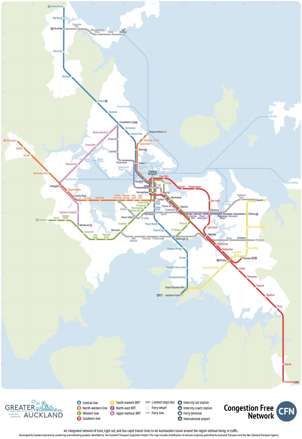
Like this, the 2- line Light Rail network in the CFN, that due north/south interlined section in the city is Queen St:
Which fits in well with this:
Which of course makes this:
a spur up Onewa, through Birkenhead, glenfield and onto Albany would be much better. as well as one from Takapuna to browns bay and back into Albany. there are some huge people catchments in these areas
like two new Link routes. That would make it easier for people to get to the NEX
How about we build a rail tunnel where it’s needed, that’s future proofed for vehicle lanes, but we’ll worry about those lanes being impossible to usefully connect to the roading network later.
Should balance the manukau crossing nicely.
It’s worth noting that Berry got exactly 157 votes. Big motorway plans are not supported. Lucky for NZTA they don’t face election…
The Act dude must have something against parks and cemeteries. Or maybe he thought he could double the number of parks by putting a motorway through the middle of each one.
…just a nostalgist; cemeteries used to be the m’way planners bread and butter, sort of fitting I guess, given how efficient auto-dependency is at filling them again…
The tight S-bend in his alignment would have done a great job in that respect.
“…The Act dude must have something against parks and cemeteries…”
No he has just got a hard-on for private property rights and the “cost savings” of ramming his motorway through the countryside rather than housing.
The Act party, despite their libertarian pretenses, IS private property rights.
Property rights can liberate you from the labour market.
Best thing to do will be to close Cook and Wellington off/on ramps now and build up the area around them. Cook/ Mayoral drive suddenly aren’t traffic sewers and AWHC can do what it like, but won’t be coming through there.
Cut and cover also won’t be possible, there are buildings in the path, one of which will soon be filled with rich white people.
Just bury the southbound viaduct, bypass the city and be done with it.
Agree with closing those ramps, yes. Then they need a busway from Drury or thereabouts up SH1 to meet the northern busway, with associated infrastructure along the way.
Good post. There are many inaccuracies in the last image (from NZTA?) 2016 Peak Congestion map, where just for example: 1). Besides all the other north shore roads showing no congestion?, only bits of Onewa Rd have anything of note and 2). a minor paper road (inaccurately drawn across Little Shoal Bay) is shown as an arterial route.
Council and the local board have washed their hands of the bay and are effectively encouraging increased traffic through the reserve to keep the wheels turning on Onewa – that’s why the bus lanes have been so successful, shifting traffic onto local streets. Only trouble is, the land is sinking, the drains are filling with mangroves and every very high tide that coincides with a low-pressure system means that all this massively increased traffic is getting a nice salt wash. I suppose in future the LSB boat owners who trash the area every winter could provide a ferry service across the bay if you dare ha ha.
2046 that was meant to be of course…
For responsible financial planning, isn’t the best plan to optimise what we have so that we can truly see what we need next?
This means maximising the flow throughput of people over the bridge, and freight, in some balance. I’d start with converting it all to buslanes, trucklanes and cyclelanes, with a few permits for selected other vehicles as required.
This would have the advantage of reducing the need for parking in town, meaning much land could be freed up for better uses, leading to good agglomeration and associated economic health.
It would also decrease the car dependency of many people, and increase the liveability and walkability of many areas. It would provide many people with good public transport options, meaning the whole network would be patronised, and therefore funded.
Later, we can see if a second crossing of any sort is required.
Is there any likelihood of changes in sea level affecting any of these plans? Seeing the time frame is sort of long it might be better to concentrate on CFN2 implementation and leave this fr a bit later?
About time the politicians formally instructed NZTA to stop being the NZ Motor Vehicle Agency and really become the NZ Transport Agency. And if that’s too hard for NZTA, then replace as many staff as are needed to achieve that.
Perhaps the government should use the ‘crossing the harbour’ concept as a testing ground for NZTA staff. Keep your job if you understand that the worst thing we can do is induce more traffic into the cbd and city road network by increasing road capacity across the harbour. Rise through the ranks if you understand the need for converting what road capacity we have across the harbour to more efficient modes.
What is so stunning about NZTA’s plan is that the modelling shows so much traffic entering the cbd even though it doesn’t include newly generated trips from the extra road capacity.
The differences in traffic numbers between the 2026 Do Minimum and the 2026 AWHC option only include traffic that has diverted from a different route, mode or destination (without land-use changes).
What we all think of as ‘induced traffic’ – ie NEW TRIPS – haven’t even been included.
So what would actually happen to congestion, carbon emissions, walkability, liveability is FAR FAR WORSE than this modelling suggests.
Does the modelling allow for the CBD lanes taken up by planned busway and LRT lanes? Those are noe funded and committed projects, so the modelling really should be redone. Does this become Aucklands bridge to nowhere?
You know, for probably less money than would be saved by not building this and the EW Link, you could build a very nice RTN…. just saying.
I have one vaguely pro-road thought on this. How old is the current bridge, what condition is it in, and when will it need replacement? It must have a finite life. You could build a new structure, perhaps cable stayed to match the city of sails image, with the current number of traffic lanes (no more), plus allowance for TWO rail tracks, pedestrians and cyclists. Then you do not have to touch the approach roads, get higher capacity LRT to the north shore with a minimal footprint adjacent widening, and probably save billions.
Just for the record can I repeat something that should be far more widely known: the Meola Reef route favoured by Berry and others is a total nonsense, founded as it is on the assumption that the reef forms a ready-made causeway that spans over three-quarters of the distance to the North Shore. In fact the reef consists of a relatively thin (6-8m thick) layer of rock floating on 60 metres or more of soft sedimentary gloop. Any structure built over the reef would require deep piles founded in the underlying bedrock so rather than viewing this as the narrowest part of the harbour (and therefore favourable for bridge building) it is actually one of the widest parts of the harbour from a bridge builder’s point of view!!
+1
Hope NZTA is not continuing to waste money on investigating their road crossing, the sooner it’s directed to a rail & active mode only one the better.
Route protection planning continues to this day. It’s interfering with any efforts to do much with Cook and Union streets, even though it’s a ‘2046 and beyond’ project in ATAP, 30 years from now.
And this is where the government needs to act now.
Genter said “Communities shouldn’t have to jump through complex and time-consuming processes just to set safe, sensible speed limits outside their homes and schools.” That’s speed, but we shouldn’t have to jump through complex and time-consuming processes just to see safe, sensible transport planning, too.
Surely you first look at what is planned for the city, and then say OK how do we implement transport to support the plan? Therefore it’s the other way around, the city centre master plan should be preventing anything in cook and union st being used for a new motorway.
lovely team Better-transport gang~! Can we please have a enlighten debate of the merits of a bridge rather than a tunnel. More I look at things I think a Bridge will actually be more aesthetic for us. Lovely big designed bridge! 🙂
Time for Patrick to show us some nice pictures of bridges, yes? 🙂
https://inhabitat.com/finlands-longest-bridge-will-be-a-beautiful-pedestrian-and-cyclist-superhighway/kruunusillat-bridge-by-knight-architects-and-wsp-finland-1/
Boom!
Cool video here too. The dialogue is in Finnish but the images are self explanatory: https://youtu.be/OHpMSUnc_Ok
Wow. That’s some PT and active mode infrastructure! This, in a city that, as Sock Puppet’s link shows, is not so different in density and variation in density from Auckland.
Tell me again why we’re building Mill Rd and not a fantastic PT and active mode corridor in that location? At least in Mill Rd, it would be cheaper than Kruunusillat, being on land, and could be flanked by well-connected walkable dense neighbourhoods. Being bridges, the Kruunsillat bridges don’t offer this. (They touch down on the island of Korkeasaari, which has the zoo.)
Yet the Finns still do it, and we still don’t.
Nick, very nice! Can they make two copies of the plans, and change the title on one? Helsinki has similar population density to Auckland, so quite a valid comparator.
https://chartingtransport.com/2015/11/26/comparing-the-densities-of-australian-and-european-cities/
The Finns do concrete, don’t they? We do concrete too. In fact, the Kruunusillat bridges (silta is singular, sillat is plural, btw) reminds me of this:
http://maxbuild.co.nz/project/sh1-newmarket-flyover/
The Kruunusillat picture’s nicer, of course, thanks to the harbour, and the lovely transport modes. But I agree with Yo-yo-yo. We can do better. Ant’s is more interesting.
The cost is also interesting – €259 million ($450 million NZ) for a 1.2km bridge. Finland has higher average wages than NZ, so again it should be possible to do something similar here. Maybe their harbour is shallower, but still, as we have all said before, a nice bridge would be a lot cheaper than a tunnel that still wipes out a park where it hits the surface.
This link has more details:
http://www.worldhighways.com/categories/road-highway-structures/news/helsinki-approves-the-crown-bridges-kruunusillat-project/
I imagine their construction costs are way lower, they don’t have the supplier duopoly we have in NZ, and their local market is 450M people so lots of firms interested in bidding on the build.
Our bridge would need to be about 10% longer and about twice as tall (to match the existing bridge clearance), but otherwise it’s a good example and I guess we could expect a similar cost at around half a billion NZD.
Our local market has about three billion people in it, including two of the three largest economies in the world. Unfortunately we’re a little bit racist when it comes to infrastructure suppliers.
That is a funny definition of ‘local market’. china/japan/india are half a world away, we don’t have a customs and regulatory union, and we don’t have freedom of movement. The Finish can be as racist as they like, but they can’t stop the Spanish bidding on contracts nor Spanish workers working there.
In fact China is closer to Finland than to NZ.
We have a free trade agreement with China, and three Chinese mega consortia already set up in Auckland ready to start building. They are in the local market and ready to go. So lets go.
This one’s much shorter but still interesting… https://inhabitat.com/portlands-tilikum-crossing-to-become-americas-first-car-free-bridge/tilikum-crossing-trimet-1/
love the double curve, make it a colour. think we could do a better bridge
Love the double curves, need some colour though, think we could do an even better bridge Here Is some bold ideas: https://www.neatorama.com/2015/02/25/15-Designs-for-a-New-London-Bridge-Look-Straight-Out-of-a-Sci-Fi-Movie/
https://encrypted-tbn0.gstatic.com/images?q=tbn:ANd9GcTNP4kZH2hm_ew-iL8bwmgqdj_fvjk-1WVTfeR6j2kNW2V2fYuE very cool
Hey Peoples, really think a bridge for Rail and Walking is the solution and here is a design that could work. Basically imagine a clean blue curved structure bridge which sort of raps around the current harbor bridge. If you get the design right both bridges will compliment each other. One idea is a curve which goes under or over the existing bridge twice or more , it could both curve horizonally and vertically to give a lovely wave feel around the bridge. Make use of the creative dogs leg that brigde is on. There are many options here is the foot print of the design : https://www.google.com/maps/d/u/0/edit?mid=16cxUmdsvwhwZ0UzZZQ5IF19ZMjg&ll=-36.82758604243851%2C174.74415779177252&z=15 please if someone can use sketchup see what they could render to compliment our existing bridge. Cheers
Anthony
Maybe I missed something, but I couldn’t find anywhere in the article where all the extra vehicles that are going to be pouring into the city are going to park; and don’t mention autonomous electric vehicles, because they will need somewhere to park and charge as well, otherwise they will be just driving themselves round in circles all day.
The AVs will just head home again. Double the vkt to reduce the parking demand. Requiring energy, even if it is electricity.