Earlier this week, we announced some updates to the website, including a new section that’s all about taking action.
Today, we’re excited to launch our first new campaign: a petition in support of Nicolas Reid’s brilliant bridge proposal for the next Waitematā Harbour Crossing.
We’re asking for this design to be included in official consideration of the options. We’re also calling on central government and Auckland Council to ensure the whole process is open and transparent to the public.
Why we’re starting with the next harbour crossing
Because it’s a critical project for Tāmaki Makaurau, and will shape our city for the foreseeable future. It’s quite literally at the very crux of our transport connections, as a harbour city. One way or another, it will be transformational.
That’s why it has to be right-sized, and done right, for all the right reasons and purposes.
But for years now, politicians and government agencies have been going around in circles, failing to progress any serious proposal. NZTA in particular has operated under a shroud of secrecy, constantly pushing towards an over-the-top and wildly expensive road tunnel, designed for traffic only.
They seem be ignoring, or have perhaps lost sight of, the basic requirements of any new crossing:
- it must be multimodal, with connections for walking, cycling, scooting, and rapid transit
- It must be affordable, and not consume all project funding and resources
- It must be deliverable, to ensure we can actually build something that addresses resilience issues with this critical connection
So, let’s remind them what this is all about, who it’s for, and what Auckland can and should aspire to.
Why we need a fresh vision – and the process needs a reset
Recently, there was a glimmer of hope when former Minister of Transport Chris Bishop announced a refresh of the official approach to the project. However, we remain concerned about the risk that this process will merely repeat the same old pattern that has persisted for decades and spit out yet another unworkable scheme.
The prospect of a new incoming government – whatever shape it takes – offers a prime opportunity for a truly fresh approach that will take this project forward.
But given the painful history of attempts to reset the process, our only real chance of a great outcome here is if we, the people, seize this moment to speak up – as loudly and clearly as we can.
Auckland’s Mayor has been good at calling out the flaws of the current approach, and he’s absolutely right to champion a sensible bridge, albeit in the wrong location.
This is where Nicolas Reid’s proposal comes in.
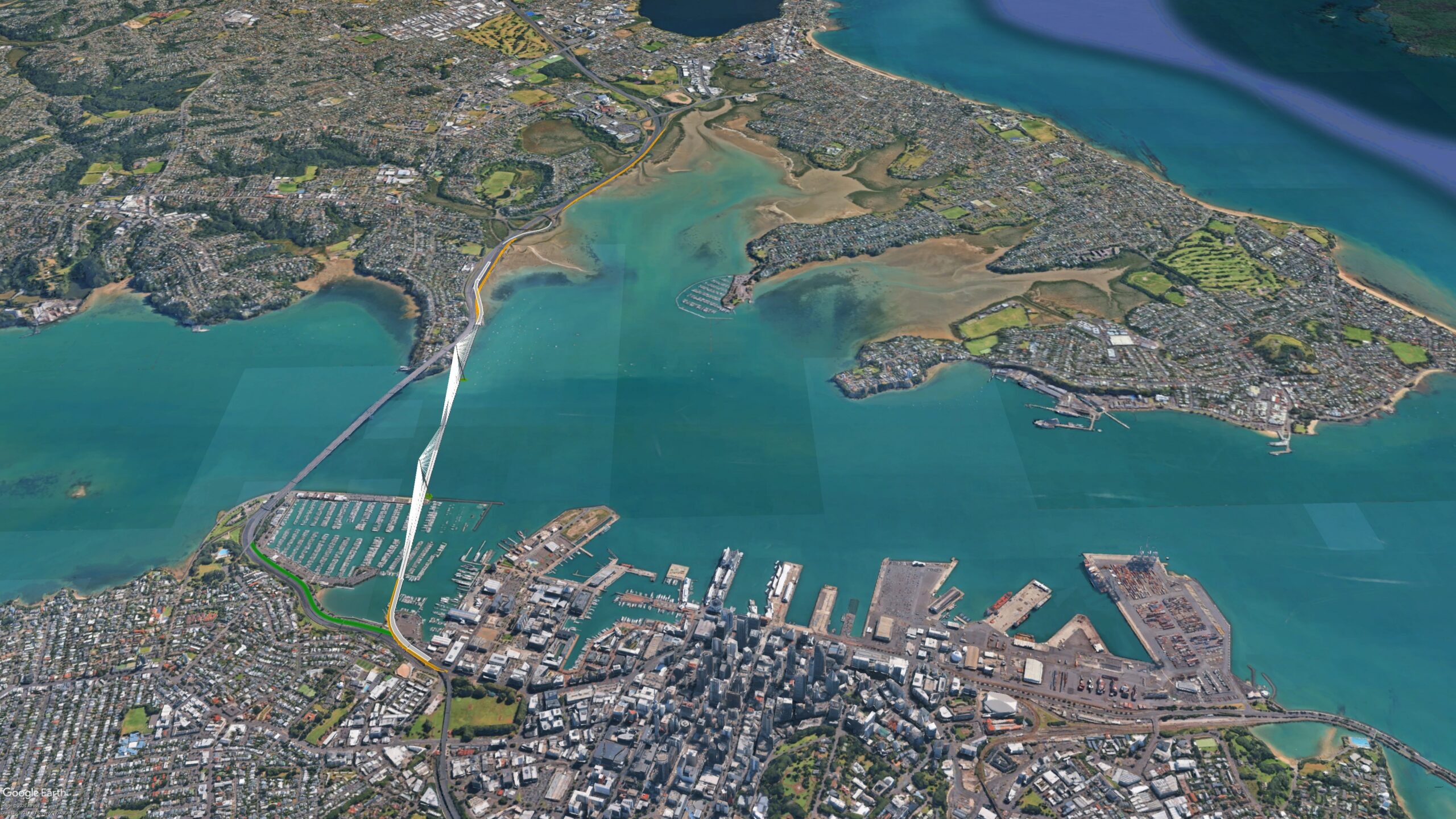
An overview of the alignment of the proposed new bridge. Image: Nicolas Reid/ MRCagney
As carefully laid out, Nicolas Reid’s plan would deliver enormous improvements to the connection between Auckland’s city centre and the North Shore.
In particular, and especially compared to the mega-tunnels for traffic alone, Reid’s multi-modal bridge would offer:
- Rapid transit connections, with potential for rail.
- The ability to walk, run, ride or scoot over the water.
- Untangle local car trips from freight and long-distance travel.
- An iconic structure that shows our city at its best.
- A bargain compared to tunnels, letting our budget do so much more!
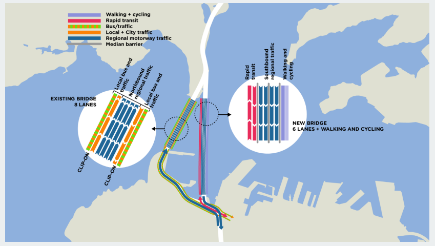
The network plan, showing how state highway lanes, city traffic, buses and rapid transit would work across the existing and new harbour bridges. Image: Nicolas Reid/ MRCagney.
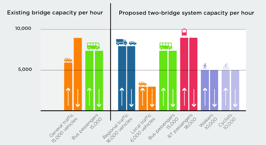
Capacity per hour of the current bridge, and the proposed two-bridge system. Existing: 30,000 people per hour in cars and buses, compared to 75,000 people any way they like. Image: Nicolas Reid/ MRCagney.
What our petition is asking for, and why
We’re asking for a fair, open and transparent decision-making process that will bring our city into the 21st century. It starts with putting this design in the mix for consideration – because it throws into relief the actual problems Aucklanders yearn to solve.
Adding the “missing modes” to the next harbour crossing is a no-brainer, especially making sure it’s future-proofed for rapid transit connections. Like light rail from Takapuna to the Town Hall.
Because guess what – for the difference in budget between this bridge and a mega-tunnel, you could build that light rail line, continue it along Dominion Road, and complete the Northwestern Busway as well! Clean, efficient public transport to every quarter of the city.
Moreover, this bridge deliberately disentangles local driving from longer-distance journeys and freight – making driving more straightforward, and helping free up public transport from getting stuck in general traffic.
Together, this alone would fix so much about our transport networks. And compared to pouring billions into traffic-only tunnels, it’s a much fairer outcome for our city, and a much more sensible spend for our nation as a whole.
But wait, there’s more! This bridge would not only unlock access to and across our harbour and the city at large – it would be an attraction in its own right, a proud statement of local architecture and design. Not just to look at, but to experience in any way we choose.
Because here’s the thing: by giving locals and visitors alike the chance to walk, jog, scoot, stroll, and roll across the harbour, Auckland would finally catch up with all other cities built around the water. Imagine being able to travel at human pace while enjoying our beautiful harbour and iconic volcanic skyline, for everyday journeys or festive fun, off to work, or out with friends and family, any day of the year.
And then imagine having the widest possible choice of ways to get back home across the water, any day, all year round.
This can be our future, and it’s totally achievable. But if we want to see it happen, we have to push for it.
Take action for a brilliant bridge today!
If this vision appeals to you – and we hope it does! – please help us make it real.
Join our public call by signing (and sharing) our petition to Auckland Council and the Government in support of this proposal.
Thank you so much for being part of this. And be sure to pass it on – because the more of us who raise our voices, the greater the chance we’ll be heard!
For more information
Read back through our previous coverage, to learn why this is exactly the right moment to tackle this issue:
- Give Aucklanders a real say on our next harbour crossing (26 May 2026). In which Patrick asks: “Why is the public not involved in the options for Auckland’s next harbour crossing? This is a critical issue for our city, so it shouldn’t be a state secret, let alone a single option imposed on us by fiat.”
- Build this Brilliant Bridge (27 May 2026). In which Nicolas Reid outlines his proposal for a multimodal bridge.
- FAQ on the Waitematā Harbour Bridge Proposal (22 June 2026). In which Nicolas Reid answers the key questions about the proposal.
- A new approach to the next Waitematā Harbour Crossing? (18 August 2026) The Minister’s attempt to reset the decision process.
- A response from the Minister on the Harbour Crossing reset (19 August 2026). The Minister responds to our questions about the reset.
- Moving beyond the Meola distraction (24 August 2026). Why the Mayor is almost right about the solution, and can help champion the best bridge for Auckland.
Greater Auckland’s research and advocacy is powered by hundreds of hours of work each month, and your support helps keep us going! We warmly welcome your donations, and are always open to offers of guest posts, practical help, and pro-bono expertise.
Another great way to support the kaupapa is by purchasing and wearing our Greater Auckland merch. Allow a week for delivery – and remember these are print-on-demand (no returns), so double-check your sizing before ordering!

 Processing...
I think the author is right to fair NZTA getting their hands on even this sensible proposal and cocking it up with their ‘too many fingers’ chicanery. I wonder if, once arriving at the general requirements for the bridge, a ‘design sprint’ could be carried out by competing private sector companies (similar to how the Marsden Branchline is being progressed). The jury is still out on the merits of that process (I presume) – however recent experience shows that the over-catered mandarins in the public sector are not to be trusted.
This is the same organisation responsible for such zingers as turning a light rail line into toilet duck metro tunnels under sandringham, and the worlds most expensive road per kilometre being the answer to trucks getting stuck behind parked cars on Neilson Street.
All good to make a petition, but does anyone think they’re actually going to do anything other than bury any realistic alternative to their mega motorway tunnel they’ve been planning for the last twenty years?
This solution doesn’t solve the resilience problem between the AHB (northern side) and Esmonde Road.
Once you factor in the cost of that it’s close in price to the tunnel.
It’s incorrect to state for the price difference you could deliver light rail in any sense, not to mention the busway.
Pum not duplicating every possible traffic movement in case of full outage of existing bridge (that has never happened in its whole life), is sensible right-sizing, not a fatal flaw.
The key feature of this proposal is to NOT over-build expensive and destructive duplicative interchanges at each end. Instead it is elegant, effective, and cost and space efficient.
You appear to be confirming NZTA will be over-scoping additional road connections, while completely leaving out the missing modes (only to be added much later, and partially). Where in fact the first aim of the next crossing should be to serve the modes missing from the existing crossing, its fatal flaw. Resilience is a concurrent and second order aim.
As you seem to be close to NZTA’s scheme enough to know projected cost, please do share that with us all.
Thank-you.
I think Pum is referring to the flooding issues from Esmonde to the bridge, although it would be helpful if they actually specified the resilience issues they are worried about. The bridge proposal obviously addresses that by extending the busway to act as a seawall and could easily include regrading the southbound lanes.
It does address the resilience problem, it includes a first step of a raised embankment for the new rapid transit lanes on the seaward side of the motorway (like has just been done for SH1-SH2 in Wellington), with a latter stage of motorway raising like has been done for SH16 on the northwestern causway and for SH20 through the Onehunga foreshore.
Those are not exactly simple or cheap, but they are routine, and are far more simple and cheaper than the suggested alternative.
The one downside of the capacity graph is using the same colour and icon for General Traffic in the first and Local Traffic in the second might make people who only glance at it assume it reduces car traffic and get annoyed. Maybe “general traffic” should use a mix of regional/local traffic colours and both icons
I’m concerned that is another example of Auckland getting the cake while rural areas get the crumbs. Where I live most of the ‘roads’ are dirt tracks and public transport is non-existent. I’d like to see a world-class bridge, but only so long as I don’t pay a penny towards it.
The good thing about building a right-sized project such as a bridge over an expensive tunnel means there is more funding to go around to projects elsewhere in the country!
Please correct me if I’m wrong but, this bridge seems to require extensive disruption to the Victoria Park Viaduct for SH1/SH16 Southbound lanes?
The regional southbound lanes from the new proposed bridge connect to the elevated viaduct after coming through Westhaven. In order to build this you would have to close the Viaduct as you would have to demolish the existing ramps up to them, in order to connect the new bridge (as it says on the annotated graphic)
So, where is existing southbound regional traffic meant to go in the meantime? Not sure what alternate route SH1/SH16 traffic could take while this is being built.
Can’t imagine a new connection (new bridge to existing viaduct) would be a quick build, at the very least 6 months- 1 year?
I do think its the best option presented so far but I’m not really sure it’s entirely feasible. Not to mention the inevitable legal challenges from Westhaven boaties who I imagine will be reluctant to have a giant bridge cut through their marina.
I personally feel a PT/Active modes bridge from Wynyard Q is the best option!
I wonder if it would be better to make the new bridge walking, cycling, busway and local traffic, and use the existing bridge for motorway traffic. That way you don’t have touch the motorway at the city end, and at the northern end it shouldn’t be too difficult to connect up (two lane overbridge). Also there wouldn’t be as many noisy trucks to walk and cycle past.
This is all assuming the current bridge can last.
In that case may as well go to Wynyard, which may resolve other issues too.
That’s not a bad concept at all and one of the options looked at. It seems it’s actually a bit harder to build the tie ins to the networks at either end with more property impacts (or structures), although there may be better designs to solve that.
More to the point tho, this proposal has 2×2 motorway connected lanes on the new bridge, from the middle of the motorway north to the middle of the CMJ south. That is so that it can be used bidirectionally for the state highway in case the old bridge is closed (effectively the victoria park viaduct running two ways like it was initially designed).
In particular, it’s designed so that in the first stage of opening adds four highway lanes (plus rapid transit, walking cycling), so four lanes at a time on the old bridge can be closed for reconstruction without reducing traffic or bus capacity from what it is today.
I.e There’s about a two to three year period for major renewal of the old arch structure then rebuilding or replacement of the clip ons one after the other. One reason a cheaper and quicker bridge is worthwhile, you still have plenty of work to do once the new crossing is finished.
Once that second step is finished the final arrangement goes in place, effectively adding the two dedicated bus lanes and the two extra counterpeak motorway lanes to the existing eight lanes, plus the rapid transit, walking and cycling of the first step.
Of course they’re might be better ways to do that with temporary lanes and ramps and stuff, but at this point it looks like this is the easiest to manage during construction and in the long term (without assuming multiple tens of billions of dollars, you can do anything if you assume infinite money).
Yes, building this would involve extensive disruption, with several stages of lane diversions moving back and forth and temporary ramps to the viaduct.
You would expect Waterview connection levels of disruption during construction, for the similar outcome of building major new structures in and around a live motorway and tying into the same lanes.
You will have this for any harbour crossing, potentially much more.
Installing a new bridge with same landing points as the current bridge is like having a heart bypass that circumvents the only non-congested sections of arteries. It is just plain stupid!
I don’t think you’ve reviewed the proposed design if that is your take. Interested to know what your preferred solution is though.
Check out a more detailed explanation here:
https://www.greaterauckland.org.nz/2026/05/27/build-this-brilliant-bridge/
And FAQ answers:
https://www.greaterauckland.org.nz/2026/06/22/faq-on-the-waitemata-harbour-bridge-proposal/
It should address your concerns!
All this talk of another harbour crossing misses the most essential point. It’s not public access or rail, albeit they are important. What any new crossing has foremost to address is a bypass. The same traffic that sits north and south of the bridge is faced with the same gridlocked conundrum. The only way over is through. Why does traffic not needing to enter the CBD sit in the same queue as the traffic that does? A bypass starting several kilometers north and south (incorporated into the new crossing) would separate the destinations and undoubtedly ease congestion.
If you look at the proposed design it does exactly that.
Check out the explanation here:
https://www.greaterauckland.org.nz/2026/05/27/build-this-brilliant-bridge/
And FAQ answers:
https://www.greaterauckland.org.nz/2026/06/22/faq-on-the-waitemata-harbour-bridge-proposal/
The proposal would separate out local and regional traffic so!
That’s what Time of Use Charging is for. The crossing happens much later because of that.
What we need is a beautiful process that looks at all the options objectively. Greater Auckland is burning its bridges, and tunnels, by prematurely supporting 1 option with a questionable claim to beauty and appropriateness for the Waitemata.
We want to have that open conversation! Especially around the potential architectural design of a bridge crossing.
There hasn’t been much mention of whether the current bridge can last the distance. I keep hearing conflicting opinions.
And also the wind factor which results in the bridge closing reasonably frequently.
Not necessarily saying either is an issue…
This isn’t a great idea. First, what problem is a new bridge trying to address? Between congestion charging, PT, more WFH and the Western Ring Route – traffic across the harbour bridge is reasonably stable and will remain that way. There isn’t a desperate need to add 4 more lanes. If there was a desperate need to split local and long distance traffic, it could be done by simply continuing the barriers from the south end of the harbour bridge until the beginning of the Vic Park Viaduct.
Short term – all I’d do would be to continue maintenance, put congestion charging on, if bus congestion over the bridge got bad turn a lane each way into a bus/emergency services lane. If there were heavy vehicle issues, I’d require them to travel via the WRR, obviously adds a bunch of cost to their journeys, but compared to the cost of building a new crossing it’s nothing.
Medium term – I’d build a CRL2 from Parnell, via uni/Aotea/Wynyard/Akoranga to Smales Farm, with the emergency exit being an active modes route. Would allow north – south and east – west trains to be decoupled allowing far greater frequency on all routes – allowing Sylvia Park – Mt Roskill services to overlay EW (as level crossings out west won’t be done for a while nor the Westfield junction fix) and CRL itself be able to ramp up frequency far more without the Quay Park constraint. This isn’t my idea, and expect a post at some point from the person whose idea this is.
Far cheaper and will do far more for Auckland than adding extra lanes (which wouldn’t achieve much, as the harbour bridge isn’t the network constraint for peak flow traffic).
Long term – tunnel (or bridge, but bridge looks worse + wind which is the main issue with the existing crossing) across from Vic Park, with bus only lanes/emergency shoulders, active modes, and space for a rapid transit link (as by that point, rail will likely be hitting capacity along the busway corridor and there likely will need to be some sort of metro solution as well).
Then the harbour bridge if the clipons could be kept, both given to active modes, with 2 of the 4 lanes being for bus lanes/emergency lanes (eventually trams for Onewa Rd as trams make sense for overwhelmed local bus routes rather than a magic bullet GA seems to view them as), and the other 2 local traffic. If the clipons can’t be kept, the local traffic lanes would be removed, and the bridge would become active modes and PT/emergency services only.
—
Auckland doesn’t need another harbour bridge, it needs CRL2 and a safe way for active modes to get across the harbour. With the enormous budgets for AWHC, it looks like we could get light metro along the NW from Mercury Lane to Westgate, CRL2 and the start of A2S with the same money. I like driving, but in terms of Auckland’s core road network, it’s complete.
The solutions to improve it are mostly demand management, more variable speed zones (with the default being 100, not 80 in offpeak times), and in terms of congestion for the harbour bridge, roading wise closing Wellington St onramp to all bar emergency services, so that the SH16 onramp ramp signals can cycle through faster to reduce congestion. Arguably closing Curran St onramp to all bar buses/emergency vehicles too, but that would personally slow down trips for me, and I think the bigger pinch point is the Vic Park tunnel than the bridge.
I completely agree. I struggle to see a really compelling need.
I would put properly sorting out our broken healthcare system well above this as priority, for example
Further, an admittedly not ideal situation across the harbour acts to incentivise more, denser housing in central locations
The Nation’s hand is going to be forced on the bridge at one point or another. If things are left as-is, the existing bridge will need to be either partially or totally shut down for extensive multi-billion dollar repairs (heavy use catching up with it).
I personally think that we need to prioritise growing the economy (we’re already borrowing to fund existing health services).
The reason an extra harbour crossing is needed is so that we can repair and replace the existing clip-ons on our current bridge. Unlike the main bridge span, the clip-ons have a limited lifespan and can’t be continually repaired/reinforced due to metal fatigue and weight limits. That’s why any new harbour crossing needs at least 2 car lanes. The clip-ons CAN’T be kept.
Of course, we could just remove the lanes without any mitigation but that wouldn’t be politically viable in this landscape haha
I know the clip-ons can’t go on indefinitely for heavy traffic, but I thought they’d first restrict heavy traffic on the worst clip on, then both clip ons, then by that stage they’d be building the replacement.
Then once the harbour bridge has been replaced a new route for all traffic, then the clip ons should be able to handle the weight of people walking on them, and the harbour bridge could become a local road between Pt Erin and Onewa Rd, with the middle span being one lane general, one lane PT/emergency services. If the clipons couldn’t be kept, having the outer lanes being active modes and the inner lanes being PT/emergency only lanes (and local traffic between Onewa Rd/Ponsonby uses the motorway instead like they do today) works fine too.
In all the NZTA plans I’ve seen though – they vary between “we can maintain the harbour bridge indefinitely” and “we need to do lots of maintenance and the clip-ons will eventually need to have heavy vehicles restricted”. The use for the harbour bridge seem to just envision it as a gigantic 8 lane on/offramp for the CBD.
If the harbour bridge can handle existing traffic with lane restrictions on the clip ons, then I don’t think we need to act until where that becomes a risk of happening before the replacement is done. If that’s already the case, then they shouldn’t be planning the harbour bridge as an offramp, but instead it should be a local road and they should be planning the offramps as part of the new project.
In terms of need, if the harbour bridge can stay as is, then our only need is better PT links (and active modes).
—
I do think AWHC is needed at some point – as I agree the clip-ons won’t last forever. But there is a massive difference between 10-20 years and 40-50 years away, and in terms of big infra projects for Auckland, there are so many low hanging fruit (turning all motorway shoulders into bus/emergency lanes, so we can run rapid lite busways along each corridor as an interim until demand exceeds capacity), medium hanging fruit (A2S, A2B, Dom Rd LR) and better fruit (NW light metro, CRL2) before we duplicate existing road lanes in a part of the network that isn’t the cause of congestion.
There are plenty of roading only projects also long way ahead, from low hanging fruit (more variable speed zones with 100 rather than 80 being the default off-peak, closing Wellington St so that SH16 ramp signals can cycle through faster to reduce queues), medium hanging fruit (Silverdale Diverging Diamond interchange, similar with Lincoln Rd etc.) and motorway projects like alternative SH16 route.
The PT stuff across the harbour bridge we’re projected to need now (the busway hitting capacity in a few years they’ll be able to push out the date by various busway upgrades, but that’s only giving a decade or so more), the active modes are an easy addition to any project, but vehicle traffic is expected to stay static or fall (congestion charging, WFH etc).
Personally I think the vehicle traffic will increase a little bit just due to population growth (mostly trips inter peak and on weekends), but it will plateau because there is no financially responsible way for NZTA to provide enough lane capacity throughout the network to cater for them, which leads to congestion, then people seeking alternatives.
It should have been done 10years ago and keep the national government out of Auckland projects
Another hugely expensive piece of infrastructure?
You need to appreciate that the age of abundance is over. We need to become much more adaptive, and live more in line with our means.
Isn’t that the point, a bridge to live within our means instead of twenty billion bucks for a motorway tunnel to Smales Farm to try and outspend Sydney?
I don’t understand the case for the alternative harbour crossing..
When it comes to the road option – resilience? That’s why we built a multi billion dollar WRR, congestion? Haha, 2 massive huge interchanges aren’t doing anything good for traffic, especially if the 8 lane harbour tunnel needs to somehow rejoin up with the existing SH1, 16 lanes merging / diverging? (8 per direction), have fun.
But you guys aren’t suggesting that which is good.
However, I’m not convinced on light rail (to the shore) either, realistically your 70m trams through city centre streets can only be ran at 20tph. That’s only a capacity of 9k an hour assuming 450 people per vehicle, the busway can manage very close to that with changes to the city side and Albany side as well as dedicated lanes on the bridge.
Deciding for the light rail to go to Takapuna is certainly one of the decisions of all time. Onewa road carries about 15k bus passengers a weekday. Takapuna? 2.2k (on specifically the 82 bus.) It honestly feels Takapuna was chosen just because they happen to have a tall building.
This proposed bridge would be a lot cheaper without four regional traffic lanes. The Western Ring Route already exists as a regional bypass. It would also be far more pleasant for walkers and cyclists.
My proposal is to wait on building this until Dominion Rd light rail has been built, preferably with a city centre tunnel. Then extend light rail over a PT and active modes dedicated bridge on the proposed alignment over to a terminus parallel to Akoranga busway station. This would allow the Northern Busway to continue operating during construction. Then convert the Northern Busway to light rail, while reserving a lane in each direction on the Northern Motorway for buses.
Commenters here have mentioned light metro as a possibility due to capacity concerns, which is valid. I would add that Sydney-style surface-level light rail may not be appropriate for the regional scale of the system GA has advocated in the past, with alignments from Hibiscus Coast to the Airport for instance. Light metro on the other hand has specific technical demands that restrict construction options. So that’s why I favour tunneled light rail. Yes, that’s right 🙂 My main beef with ARL was the unnecessary tunnel down Sandringham Road. Otherwise serving the uni and hospital is solid.
I have always wondered if there could actually be a bridge that extends the train service to north shore?
That in a way could reduce the buses going across to bridge that gap in the connectivity.
Many countries have bridges for trains. Along with the new bridge for vehicle we should really consider have one new bridge or the same one being built to cater to trains.
I know this is easier said than done, but it’s just food for thought!