In the history of Auckland’s many transport blunders, not building a busway along the Northwestern Motorway at the same time the motorway was being widened and interchanges rebuilt, when the need was clear and the success of investments like the Northern Busway were already understood, is up there with some of the worst we’ve had.
Fixing that mistake is going to take a lot of time and money and the first step was implementing the interim rapid transit service on to the Northwest, the WX1. It is already showing to be a great success and exceeding expectations and usage in March alone was up 24% on the March last year. The service is due to get better too with electric double deckers expected soon.
However, the long-term solution has always been a proper dedicated corridor, like the Northern Busway. There have been various investigations for this in the past, such as an indicative business case in 2017 but this iteration of the project was kicked off back in 2023 under the previous government and thankfully has been continued by the current one. Yesterday Transport Minister Chris Bishop announced that it has taken a step forward with the NZTA board endorsing an investment case for the project.
“The northwest of Auckland is home to 90,000 people and is one of the city’s largest planned growth areas. By 2051, an additional 100,000 people are expected to be living in the area, with 40,000 new homes, and 40,000 new jobs based there. Delivering faster, more frequent, and reliable public transport is essential and will ensure the transport network can accommodate this growth and ensure people can get where they need to go quickly and safely,” Mr Bishop says.
“Currently, people in the northwest don’t have reliable public transport options, and 60 percent of residents commute out of the area. Most people travel to work by car, more than any other area in Auckland, and the Northwestern Motorway regularly suffers from congestion and delays.
“Identified as a priority in the Government Policy Statement on Land Transport 2024 (GPS), delivering the Northwest Busway will be a game changer, and will build on the success of the Northern Busway, City Rail Link, Eastern Busway, and other public transport improvements across Auckland.
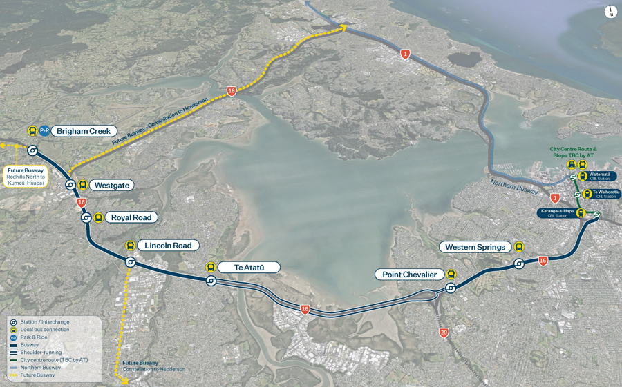
“The Northwest Busway includes a park and ride station at Brigham Creek and stations at Westgate, Royal Road, Lincoln Road, Te Atatū, Point Chevalier and Western Springs. It will be able to move up to 9,000 passengers per hour in each direction – the equivalent of four motorway lanes. It will also provide a reliable 25-minute journey time from Brigham Creek to the city centre – all day, every day.”
 There’s nothing new or revolutionary about what’s proposed above, in fact it’s very similar to what was proposed in that 2017 business case, but the funding for consenting and property acquisition means it has progressed further.
“The staged construction programme in the investment case prioritises benefits to West Aucklanders sooner and focuses on more people benefitting from faster and more reliable journeys, as quickly as possible, while building on the hugely popular WX1 service,” Mr Bishop says.
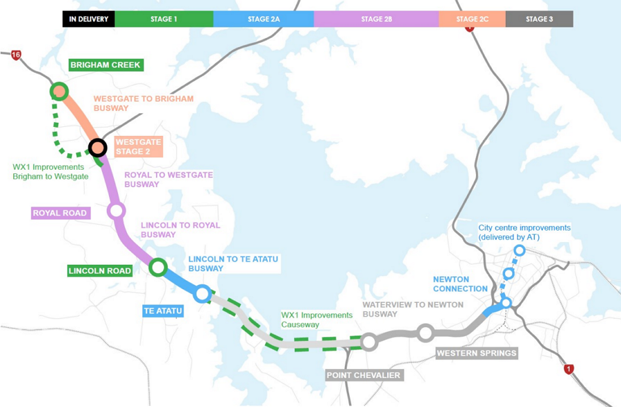
“Work is already underway on a new station at Westgate, funded separately by the Government’s Infrastructure Reference Group, with the first stage, which will serve local bus services, expected to open in mid-2026.
“Funding of around $116 million has also already been approved by the NZTA Board in late 2024 for early consenting work and strategic property acquisitions for Brigham Creek and Lincoln Road stations. Depending on further funding availability, construction of the Northwest Busway could begin from 2027.
“Stage 1 will see new stations at Brigham Creek and Lincoln Road as part of a $330m – $380m package of work. Stage 2 will include the separated and bi-directional busway from Brigham Creek to Te Atatū, along with the stations at Royal Road and Te Atatū, the second stage of Westgate station, and the city centre connection at Newton at an estimated investment of $4,100m – $4,600m*. The Point Chevalier and Western Springs stations are to be delivered as a third stage.
“NZTA will be engaging with stakeholders and landowners to discuss what the Northwest Busway means for them and next steps. Further design and investigation work will be carried out in the coming months, ahead of lodging Notices of Requirement. The project will now seek to obtain statutory approvals for the project, likely via the Fast Track Approvals Act.
…..
“Built in stages, the Northwest Busway delivers a strong case for investment with Benefit Cost Ratios of 6.3 for Stage 1, and 2.2 for Stage 2. Incremental delivery is expected over multiple National Land Transport Programme (NLTP) periods, spreading the investment to enhance affordability, and provide a strong pipeline of work for the construction sector into the future.
“This is a common-sense project that will be transformational for the Northwest of Auckland. We need to get on with it, because congestion will only continue to get worse, current public transport will become overcrowded, late and unreliable, and economic growth and productivity in the Northwest will go backwards if we don’t.”
| Estimated investment | Benefits | |
|---|---|---|
| Stage 1 Brigham Creek station and Park & Ride Lincoln Road station WX1 improvements | $330m – $380m* | Benefit cost ratio 6.3:1 $6.30 of benefits for every dollar spent Serve around 4,500 passengers per day |
| Stage 2 City centre connection at Ian McKinnon Drive (Newton connection) Te Atatū station Royal Road station Busway from Brigham Creek to Te Atatū | $4,100m – $4,600m* | Benefit cost ratio 2.2:1 $2.20 of benefits for every dollar spent |
| * The estimated investment envelopes assume the project is delivered in the next 10 years and factor in 30% for escalation and administration. | ||
| Stage 3 Point Chevalier station Western Springs station Busway between Waterview and city centre | NZTA will seek statutory approvals for the project, likely via the Fast Track Approvals Act, but this stage is not expected to be delivered in the next 10 years. | |
Wow, a BCR of 6.3 for stage one is impressive and certainly better than we’ve seen for any of the Roads of National Significance – notably the two RoNS announced over the past few days made no mention of their BCRs. Even stage 2 with a BCR of 2.2 looks good even though it’s over $4 billion.
Building in stages makes sense and is how most big projects get delivered and yet it feels like we’re just discovering it again after a few years of mega-projectitis where we were told we have to build entire projects in one go, even if bits aren’t needed for 50+ years and could easily be delivered later.
I suspect Lincoln Rd is up first in stage 1 because the most obvious location for it, the radio tower site, also just happens to be for sale.
Perhaps the most interesting thing about what’s been released is the suggestion that at the city end the busway would connect to the city via Ian McKinnon Dr. What implications does that have for getting buses through the city.
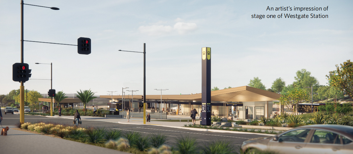
The first stage of Westgate Bus Station is already under construction.
It’s good to see this project is still progressing but it would be even better if we had more information, such as specifically where stations are proposed to be. I think it would be good for the NZTA to talk about how the busway eventually gets extended past Brigham Creek and on to Kumeu.

 Processing...
“Even stage 2 with a BCR of 2.2 when the e”
The above seems incomplete.
Thanks, fixed
$4B+ for stage 2 is totally ridiculous. Yes we have seen expensive projects in NZ recently, but this just goes to show how much of a rort these are for whoever is clipping that ticket!
The original North Shore Busway was thought to be on the pricey side back when it was built for around $200m – even accounting for inflation that’s less than half a billion. Now we want to spend over $4B for what?!
Granted inner city land prices are higher and we would probably need more aerial ramps etc but unless they are tunneling this thing that figure makes no sense.
Now if it was $4B for the entire project and all the way to Kumeu then yes maybe.
The Northern Busway, when adjusted for inflation, cost roughly $450m
At $4B for what looks to be a ~9km section, NW Busway Stage 2 comes out to around $444m per km
So that means that it’s going to cost roughly the same per km as the Northern Busway did for the entire project
Where are they getting these costings from!
It’s the inner city stage 2A portion that I have the most questions about.
“City centre improvements delivered by AT”.
“City centre connection at Ian McKinnon Drive (Newton connection)”
“via local street network in alignment with Auckland Transport’s City Centre Bus Plan, connecting with the K Rd (CRL) Station”
The maps appear to show buses travelling NW-Ian McKinnon-Upper Queen-K Rd-Pitt St-Vincent St-Albert St. A circuitous route, with few if any additional aerial ramps, and little cost for the busway project, as this is largely AT.
The City Centre Bus Plan says the lower Albert bus stops will be overloaded by the early 2030s, requiring an off street facility.
I question why buses should all route through the overloaded CBD, rather than integrating an off street facility at Mercury Lane / Canada St, to connect directly with K Rd station and the NW.
$5b is just crazy, is it going to be elevated across the causeway?
For that money just make it light rail from the start. This is where it having dominion road running is frustrating because they could just plug the city end of it into tracks on Queen Street
This. How we not afford light rail for this cost and timeframe? Kumeu to K road.
Also is bus traffic in the city no longer a concern?
100%
It’s going to be shoulder running on the causeway, even when all construction is completed in 2040 or so 🙂
I love construction cost inflation 🙂
Undoubtedly that would turn it into a 20B project.
You lose all stageability, have to deliver the highest value bits last.
We just tried light rail delivered with a megaproject. We don’t have the state or private capacity to do it.
Also Kumeu really needs an interim solution, the traffic between there and Westgate is absolutely crippling from 6am onwards
Some kind of bus lanes on SH16 are needed, could they not repurpose the wide median as some kind of tidal bus lane during peak times?
Very happy this is going forward but still don’t understand how it can take this long and cost this much.
We’re spending the money for light metro etc. for the benefits of a busway. That said, something is better than nothing, so happy they’re going to do something. Can’t let perfect be the enemy of good.
There probably is hidden in the budget rebuilding the interchanges to Diverging Diamonds or something far more efficient to get the traffic on/off the motorway. Likely some widening and massive property purchases.
Presumably LR would cost a lot more than this given this proposal requires minimal changes on the causeway.
As if NZ would have the guts to build any diverging diamonds
I’m a big fan of diverging diamonds. The potential cost and construction timescales savings, operational efficiencies and (the cynic in me thinks) the likely adverse safety impacts for active modes, could really appeal to Chris Bishop?
For Lincoln Rd it’s the only solution that makes sense for the interchange, as majority of the traffic is going to/from the motorway, and you get the traffic sorted in two phases. I just don’t see how you can add more lanes or build a grade separated interchange.
Of course, then you get to the Central Park Dr/Triangle Rd intersection straight after, which honestly needs a bridge or something like they just did in Tauranga, as there are too many traffic light phases to that intersection. So even if you’ve got a diverging diamond, the constraint will still be Central Park Dr/Triangle Rd. But given it’s the same two interchanges that mess up SH16 every day, I do think they’ll need to bite the bullet eventually and do something radical with Central Park Dr/Triangle Rd.
At least Te Atatu is doable with a few left turn only intersections nearby the interchange.
There’s land that is currently abandoned orchard that could be used for a new link road to Central Park with on/off ramps East of Lincoln Road that would help sort out both intersections.
Could also add in cycle lanes to connect to path
I’m the furthest you could be from a National Supporter, but over the past 20 years they’ve certainly done more for Auckland in terms of transport infrastrcuture than, and probably the rest of the country as well. Labour and Greens need to up their game and move past just talking up big solutions.
What? They removed the transit lanes from the NW causeway widening. And that’s just one example of their on going obstruction of transport projects other than more roads. Even this announcement is more of the same might happen could happen one day stuff. Note no actual funding is there apart from a few property acquisitions and more planning. After years of planning.
Labour:
Northern busway
Project DART
Rail electrification
Eastern busway
National:
CRL
NW busway (hopefully)
I think Labour lead the way, although CRL was pretty significant.
National delayed the CRL wasting millions. They also deleted the Beresford st entrance and shortened the platforms. So they don’t get much credit for that either.
Apologies, I thought National started and funded the Northern Busway..and again as much as I’m pro PT and cycling, roads are infrastrcuture and they did (afaik)
– Northern Motorway widening
– SH1 Northern tollway
– Victoria Park tunnel
– Waterview tunnel
– Pink Cyclepath
-Started cycleway programme
– Quay Street? Maybe that was Labour
You get my point, neither of them really leads the other.
Te Huia was mostly Greens and again, done in stages which is great and has managed to survive for now the expected culling by NACT
and yes, todays post wouldn’t even exist if the idiots had done the busway in the first place.
I’d be interested in the back story for the Cycleway Programme that seemed to be a John Key thing. Whether his trip to the Netherlands was after he/they thought of it or to glean more insight to the world of urban cycleways or that is what gave him inspiration for it? Perhaps it was just about the same time.
Also I forgot for Labour:
3rd main
Puhinui interchange and SH20B transit lanes (although disappointing they are T3 not bus lanes)
this is a Labour project read the story again ,started under last government and planning was done long before the election and land bought and paid for .
That’s a long bow, they never funded it. National haven’t funded stage 2 either yet, so if they don’t get on with it, it might still be Labour who get to claim it.
Some property purchase for the Waterview tunnels happened when Rob Muldoon was in power but I don’t think he could claim that project.
Why not change this project to light rail? We could spend $500 million on consultants, buy one property then in eight years time abandon the project completely with nothing to show for it. It would be great.
Consultants will be getting rich with the RONS and this busway proposal, don’t you worry about that.
Don’t worry that one property would have appreciated in value so much they could sell it after the 8 years and still come out on top. /s
At last the project that should have been following the Waterview Tunnel, instead of just the road widening that we got. NW cycleway was a later (and therefore more expensive) add-on, likely to be disrupted to fit the busway in. The only good news is the radio transmitter site becoming vacant. Not so, trying to find land at Te Atatu for an interchange station. Rosedale station may give ideas for how to manage Royal Rd and Te Atatu, Pt Chev and Western Springs.
I would have thought a heavy rail link deviating from the Western after Morningside and then linking up to the suggested route would be a better solution. That line could then head south via Newmarket while the East-West line goes via CRL
Sure it’ll cost more, but wouldn’t it be a better solution?
No, there is no room on the rail network for any branches without reducing frequency and therefore capacity on the existing sections
heavy rail dogmatists try to understand headways and train-per-hour capacity limits challenge (IMPOSSIBLE)
This would be orders of magnitude cheaper if it reallocated NW traffic lanes.
Doing so would also reduce vkt and create significant modeshift, furthering our emissions reductions and accessibility goals. The significantly reduced vkt would improve safety throughout local streets, a benefit they’re eschewing.
Decarbonisation done properly delivers a better transport system at a much lower cost. What they’re proposing here is simply applying expensive sticking plasters on a car dependent system. They’re sticking plasters that will certainly help individuals, but it’s not the well-conceived network-wide improvement we should be able to expect.
This.
Much quicker and less disruptive too.
And the saved billions could be spent on really making the public transport service attractive, meaning the remaining private vehicle lanes would have less traffic and everybody wins. (Refer back to yesterday’s post: https://www.greaterauckland.org.nz/2025/04/23/fares-fair-in-the-sunshine-state/)
Its the time that gets me.
We built a new 4 lane, 11km Manawatu-Tararua motorway over the Ruahine Range, in some pretty challenging terrain. 7yrs from route confirmation to opening.
This is flat, leveraging an existing corridor and while a bit longer in distance, is taking over 50% longer in time. Surely property acquisitions don’t add that much extra time if done simultaneously with other tasks.
Bang on KLK, time and cost! What gives how can we build an entire new motorway for less??? Did they take it too literally and are genuinely playing it in caviar?
The political project selection process incentivises doing bad projects first.
It’s just like the eastern busway. Everyone knows it needs to be done, it’s not very controversial, it’s all planned and the corridor reserved. No big rush. But funding is hard come by. You can just let the other guys do it next time they’re in power so you don’t have to do the controversial work of finding the money and funding it. Meanwhile you build the stuff that nobody else will.
The projects you as a party decide to do are the ones that won’t get done by anyone else.
As a non-Jafa, I look forward to reading about the progress – and debacles – of the Auckland transport systems, but reading about the North-Western Busway (sorely needed), I can’t help but wonder where the discussion in Greater Auckland is about whether the ever-expanding metropolis is actually a good idea. It seems that the various article authors have an inbuilt assumption that all growth of Auckland is inevitable and, by implication, good, and therefore what can we do to shoehorn more people into a limited supply of once-productive land. Where is the discussion about whether Auckland SHOULD continue to grow at the same rate? Is the growth in the right place? Should it be directed to elsewhere in the country? Is it always efficient to be retrofitting mass transit systems into existing cityscapes? Etc, etc.
I think it is inevitable. There are very few examples of state driven population management around the world that have been successful.
Trump & co seem to have a pretty effective ‘population management’ model in place; shipbthose you don’t like off to another dictatorship ignoring all due process. Wanna copy??
I think this blog constantly argues for increasing density in the city centre which is really low compared to other cities with the same population and against increasing the sprawl.
Is it even possible to “redirect growth elsewhere in the country” ? Population growth is largely driven by immigration, and immigrants want to live in Auckland.
Isn’t Hamilton growing at a faster rate than Auckland? Surely some redirection is possible, e.g. by increasing funding for hospitals and staff in the South Island which would of course attract professionals but also could keep people in the regions with better access to health care.
It would probably make it more attractive as a retirement destination. And there would be socioeconomic flow-on effects from that. Some good some bad.
Relatedly, and in the other direction, I think the Government may have reduced the potential growth of Wellington, by cutting a lot of public sector jobs there.
Maybe at the edges but people generally go where either the jobs or leisure opportunities are.
Hamilton is growing rapidly (as is Tauranga), but so is Auckland. And it’s an immutable law that central government will only spend money on public transport projects in Auckland or Wellington.
“Isn’t Hamilton growing at a faster rate than Auckland? Surely some redirection is possible, e.g. by increasing funding for hospitals and staff in the South Island”
I am not an expert, but historically, my perception is that “encouraging people to settle elsewhere [than they were planning to]” by govt subsidies and policies is about as successful as govts getting people to have more kids (when a govt is worried about people not having enough kids).
Why the strange comparison? I guess both where you live and whether / how many kids you have are such fundamental factors for people – and factors they have some control over – that offering some money or other incentives one way or the other often doesn’t do much. You have to use pressure that a western democracy simply can’t (and shouldn’t!) use to change those behaviours.
So I think in terms of where people live, it’s better to play to revealed preferences (which are places like Auckland, and preferably the inner suburbs, thank you). Yes, SOME people want to go somewhere else, and that’s fine. But it ain’t surprising many want to go to the very same place, and that only changes over decades, if at all.
Sure, I don’t want to see that pressure or a government assigning people to cities.
But building more sprawl effectively forces people into sprawl.
Building denser inner city centres attracts people to these centres.
Providing opportunities and infrastructure elsewhere offers possibilities and directs growth to these places. The hospital was one example as it was handled very poorly by the current government. If they would fund a new big research centre or port infrastructure in Napier along with other improvements, people would move there or stay there longer. If they closed Waikato University, a lot of people would leave Hamilton.
So I don’t understand why you are saying there are no ways to direct growth to different places. Obviously, this is not something that works within 1, 2 or even 5 years.
John – those effects would be minor at most. You could build a new university in New Plymouth and you might grow the population by 10,000 but it would do diddly squat to the population of Auckland.
It would also likely be a sink of money as there wouldn’t be much of a reason for kids from around the country to head there and it’s unlikely private sector funding would move from other more centrally located universities.
Hamilton has been experiencing fast growth, but there has also been massive resistance to the city growing up. The Council has been restricting development due to perceived limitations of the water system. Some council members favour sprawl, carparking everywhere, and no urban intensification. I think the same goes for Tauranga’s inner suburbs. The VC of Waikato wants a medical school, but has severely cut funding for other parts of the university.
Dense cities are more productive than dispersed populations, and cheaper for governments to service. Hence there are good reasons to intenstify existing suburbs. However, with the Auckland isthmus and older North Shore suburbs fighting intensification for ‘character reasons’ and the Eastern suburbs fighting intensification for lifestyle reasons and because inner city suburbs have better infrastructure and are closer to the central city, development is being pushed out to poorer areas on the extremes of the Auckland urban area.
There are probably good reasons for increasing the population of established Christchurch suburbs and Dunedin, Wellington, and lots of existing cities and towns in the South Island and lower North Island. It is good for a country to not be dominated by one centre. In addition, if the South Island population increases an Auckland isthmus electorate might be abolished and politicians there might start allowing some intensification.
Part of the Hamilton and Tauranga story has been the relatively cheap housing with some land close to the city which is not possible in Auckland.
Now that both those cities have grown considerably any further development will cost more (especially with needs for city type infrastructure) making further growth less attractive. Should result in slower growth going forward.
Hamilton is going to be an absolute traffic nightmare in a few years once more people move in. The only reason it hasn’t been congested yet is because their roads flow well. Not an easy city to make PT work either it’s weird and somewhat disconnected.
So this is meant to move 4 motorway lanes worth of people and we cannot just take an existing lane to make this easier, cheaper? the costs are getting ridiculous, it’s like asking a three year their favourite number. Between this and the northern expressway (ie world’s most expensive road ever presumably) what money is left over for anything else
with any luck they might be able to include upgrading the cycleway at Western springs and Carrington Road to something like the Te Atatu interchange i.e. no need to wait for a pedestrian crossing. I doubt it though.
AT is looking to upgrade Carrington Rd. Bus lanes, bike lanes etc. down the whole route (at least to Woodward), which is a great project, and is needed due to the massive new apartments in Unitec/bues getting stuck/lack of safe cycle infrastructure.
But as part of it, they’re also going to switch the zebra crossing to traffic lights – so no plans to grade seperate it. Personally I think they should put a bike bridge from the NW cycleway in Unitec across into Suderland St. But the plans are just for traffic lights instead.
All the SH16 crossings should be grade separated, it’s a bike highway. Should have gone under Royal Rd at same grade as motorway too…
It’s not a bike highway, it’s a shared path…
Given the number of near misses and collisions on that shared path, language matters…
in an only slightly related way I’ve recently started working in town again and noticed there are electronic signs on the way saying how long it takes by bus, car and cycle to get into the cbd and they’re almost always the same number or only slightly different at around 30 minutes from waterview. I used to ride to the CBD from near enough to the Glendene roundabout and it only took 45 minutes …who is calculating these times? the cycle is about 20 minutes from Waterview I think? and on an ebike is probably between 10-15 minutes provided you don’t have to wait at the western springs lights too long
It’s the same on Tamaki Drive, with the estimated cycle times to the city sign at St Heliers. Google maps bases cycling direction at 16km/h, I assume AT does the same.
I average about 28km/h along Tamaki Drive on my cheap commute bike, bike fly past my, probably doing 35.
I worry that they are selling us a huge project which will keep getting pushed out and in the end never happens. I would prefer working with what we have – i.e. taking existing traffic lanes, and no new flyovers! The WX only works if it doesn’t get stuck in traffic. Let’s paint out the shoulder lanes, commandeer one traffic lane and make it bus and T3, and go. And yes, traffic congestion in the city is a huge problem! Would be keen to see what solution is proposed for that
Costs in this country for large projects have absolutely spiralled out of control.
We’re looking at $4.98bn for a busway that doesn’t include busway from Waterview to the City Centre!?
Its called gouging
That’s one way to describe privatisation. We’ll thinking it 21st century Ministry of Works when?
It’s not quite clear, but what is the outlook for park & ride at the stations, apart from what is promised for the Brighams Creek station?
I believe Westgate will also have one in the existing gravel carpark.
Speaking of Westgate, no mention of old Westgate/Massey station near the Woolworths?
That Gravel carpark is private, and is apparently going to be built on, eventually
Since the station being built across the road from it. The carpark was one of the planned options for it
It would make absolutely no sense to have P&R anywhere apart from Brighams Creek, maybe
Where would you even do P&R? CBD obvs not, and has car parking/frequent bus routes. Pt Chev/Western Springs already has frequent connectors + parking. Then further out is congested around the stations so you can’t feasibly drive to them, and frequent bus routes. Congestion goes all the way to Kumeu in the mornings.
I dont know if someone has already addressed this, but the biggest problem of WX1 is actually getting out of town. Last Tuesday it took 40 mins just to get on the motorway and 20mins to actually get to Westgate. What the point of shortening the 20min journey by 5 mins (if they can) when 60-70% of the journey actually takes place in town?
That’s why the gov is making sure to say that it’s on AT to sort it out. AT could tomorrow role out 24/7 bus lanes the entire route from the motorway onramps to the end of the route. Then they’d need to beg NZTA to add bus lanes to the Newton Rd on/offramps.
But AT is also the same org that keeps a single carpark on K Rd to mess over an entire bus lane.
AT will be gone by the time the busway is built anyway so I wouldn’t worry too much about AT getting in the way.
https://natlib.govt.nz/records/31986130
In the history of Auckland’s many transport blunders…
Can we have a history of Aucklands transport decisions, and a little analysis.
Maybe it can help us avoid future transport bunders
Good it’s very much being promoted to be done in sections, but I think could be separated out even more. Especially the City Centre section which a few have alluded to how long that can take to travel on at some peak times. Why group that in with other random section way down the line. Maybe in the details of the BC it shows them separately anyway, but for public viewing like this etc should be separate.
Hopefully they can upgrade the Shared Path at the same time. That’s downright dangerous for peds at the moment (too many people act like it’s a bike only path — including commenters on this blog who believe going 40 km/hr is appropriate!).
In fairness it’s called the North Western cycleway and given the distance it covers it’s purpose is quite clear. However, I agree they should upgrade some of the bottleneck sections closer to the city.
The signage along the shared path is very clear — it’s for shared use. (Multiple names are used interchangeably.)
Anyone who thinks it’s only for bikes, can’t read clear signage (or doesn’t want to).
While widening should occur, this takes time. We can improve everyone’s safety by encouraging cyclists to follow the law today!
I thought Auckland’s leading blog for active modes would care about ped safety more….
Yep, just like the Waikato expressway is also a cycling, walking and horse riding route. It really should have a speed limit no higher than 50 kmh.
Of course common sense would say it was primarily built for the long distance movement of vehicles…
Jezza, what are you talking about?
Usage and safety isn’t defined by “What some zoom zoom cyclist on the internet” thinks — the rules are very clear.
There are clear rules on how to share the expressway, and this blog would get very upset at any motorist that endangers bikes. Despite being clear rules on how to use shared paths, this blog doesn’t show the same objection to cyclists who endanger peds.
Under your logic, a cyclist on the footpath isn’t using a path for what it’s designed for — does this mean I can knock them off? (It would certainly make Purewa Bridge safer — I was the victim of a bike hit and run on that footpath). What about a cyclist running a red through pedestrians? Or a motorist driving 50 km/hr on a road I think should 30? Under your logic, I don’t need to treat them safely…
If you think the law should be changed, change it. Until then, slow down and stop endangering vulnerable users. A4E doesn’t just apply to the CBD — vulnerable peds all across the city should feel safe.
To most people it would be reasonably obvious, but to you unsurprisingly not.
Having an unprotected lane for cyclists right next to a 110kmh vehicle lane is not particularly safe, especially with no footpath for pedestrians. The safest solution would be to reduce the speed limit to 50kmh.
Of course this would be a waste of all the money spent on the Waikato Expressway given it was designed to get vehicles from A to B as quick as possible.
It beggars belief how much energy you’re willing to throw at slowing down cyclists on the NW cycleway.
Jezza, you’re trolling.
My proposal simply requires bikes to follow the current law, and costs cyclists seconds on each journey (to make a large number of people feel safer).
Your proposal needs a law change, and would cost ten of minutes on each journey (to make a minute number of people feel safer).
To equate those two shows bad faith.
Why don’t you think bikes should follow the *current law* on shared paths? Is it because you like going ‘Zoom Zoom’? Are laws just for people you don’t like?
Here’s what the Land Transport Act states regarding priority on share paths:
Priority:
Shared paths may designate priority to cyclists or pedestrians through signs or markings. If priority is given, the appropriate user must give way.
As far as I’m aware the NW cycleway designates priority to cyclists.
> As far as I’m aware the NW cycleway designates priority to cyclists
This is an absolute lie — no such designation is given.
Why do you hate peds? I hope you’re never disabled enough that you need such paths to get around — and then some Zoom Zoom prick tells you you’re not allowed to be safe on the path you need.
Keep on reading re. shared paths — cyclists are also required to show due care on the shared path. Commenters brag about going 40 km/hr on this path. This is illegal and dangerous — but no one cares.
It’s not an absolute lie just because it doesn’t suit you’re narrative.
Have a closer look at the rules around shared paths next time you’ve got a free moment from trolling. The priority is determined by whether the bike is above or below the pedestrian image on the sign.
That of course doesn’t mean cyclists don’t still have a duty of care for pedestrians but this can be done at more than 10kmh.
Jezza, the order of the symbols mean nothing.
Do you have any source showing that the order of the icons mean something?
(I don’t normally feed the trolls, but you’re spreading dangerous misinformation here).
Section 11A (4) (a) of the Land Transport Act 2004.
https://www.nzta.govt.nz/roadcode/code-for-cycling/paths-cycle-lanes-and-bus-lanes/#:~:text=Some%20shared%20paths%20have%20signs,to%20people%20who%20have%20priority.
Sorry, a bit more misinformation for me to spread…
Jezza, why are you lying? That’s not what that section says at all. Stop lying and follow the law.
Are you stupid, or do you think everyone else is stupid?
If you’re unaware of what signage that section is actually referring to, check out the sign on the Tamaki Drive shared path (outside Kelly Tartlons). That is what a sign giving priority looks like — not the false and dangerous lies you’re spreading.
Go there — and then you can endanger peds in a whole new setting!
Jezza, did you read your link? Nowhere does it say the mode at the top of the sign gets priority. You’re wrong to claim that. Seriously, go and look at the signs on Tamaki Drive, that explicitly gives priority to peds.
You can hit peds in a scenic setting then!
I guess you’ve recognised the error of your post Jezza!
For clarity — bikes do *not* have priority on the NW *Shared Path*. If anyone other than Jezza believes this, please educate yourself before you hit someone.
No, I just realised I’d fallen into the trap of arguing with stupid people. Got dragged down to your level then beaten with your years of experience at not knowing what you’re talking about.
Why do you hate peds Jezza? Does threatening vulnerable peds and running away like a coward make you feel tough?
Also, you’re strawmanning to suggest conflicts only happen on the inner part (or you’re not a frequent pedestrian on it). You should try walking on it during rush hour, and tell us how safe you feel.
As a person who both bikes and runs to work, I can assure you I have more issues running on shared paths, than I do biking on the road.
I agree with you that cyclists should ride to the conditions i.e. if there are people about slow down as they are incredibly unpredictable and generally speaking don’t look over their shoulders to check what is coming behind them. The actual issue is that cyclists and pedestrians/runners/dog walkers should never have to share the same area except in areas like they do in Melbourne on the river banks. The NW cycleway should be a commuter highway for bikes with a separated area for peds. It shouldn’t even be a consideration to be otherwise… the main idea is to get people into and out of the CBD in a reasonable timeframe on a commute. Pedestrians and runners deserve to have a separate path that is safe and cyclists should have an area that they can ride normally without having to worry if the pedestrian is suddenly going to walk a different line or a dog walker has their dog on an extendable and the dog finds something to sniff on the other side of the path.
Agree with Steve. Yes issue is main shared like walking section is where the most wheeled traffic has accumulated over the length of the path mixing with that good local walking access section.
They have done some separating where it was cheaper/had more room to do so.
You would have cyclists under time pressure to get to work/study on time if they haven’t allowed enough time so would want to zoom by this point in the journey. Then there are those going for their time record/speed cuz they have a special app/device for it which I think is a bad idea on this path.
Steve,
> I agree with you that cyclists should ride to the conditions
First, thank you for saying this. It’s not a universal view on this blog (some commenters brag about going 40 km/hr+ on this shared path!!), so I appreciate that!
> Pedestrians and runners deserve to have a separate path
Yes, everyone supports additional infrastructure. The question is how we keep everyone safe until this is built.
And as advocates for Active Modes, it’s important to remember the Hierarchy of Modes at all times — and not forget when it inconveniences us.
We wouldn’t say:
> cars should have an area that they can drive normally without having to worry if the bike is suddenly going to pull out suddenly or a cyclist pack suddenly wants to run a red
when cars conflict with bikes, so we shouldn’t say it when bikes conflict with peds. I like going fast on my bike to, but not at the expense of other people’s safety.
Again, better infrastructure is of course needed — but there are things we could do right now, while better infrastructure is built.
For example, we could:
* Put speed limits on the path (even at 30 km/hr — no one should exceed this on a shared path)!
* Signage to put the strict liability on bikes on shared paths
* Speed calming at pinch points
* Support the former RCAs guidelines on passing peds on shared paths
Grant,
As above — everyone supports additional infrastructure. This is definitely true!
The question is how we keep peds safe, while this is built (and encourage the culture/behavioural change needed).
How do you think we can slow bikes down here (in line with the Hierarchy of Modes/Road to Zero/ensuring people of all physical abilities are and feel safe)?
We could put signs up tomorrow stating no pedestrians on the NW cycleway as it’s effectively a motorway for cyclists. It works well on the NW motorway with pedestrians and cyclists excluded.
And there we have it folks — Jezza doesn’t care about peds!
Surely Jezza is just a troll account — no-one on an active modes blog would want to ban peds from one of the most important links!
Yep, you’ve caught me, it’s definitely me that’s the troll account here…
Well Jezza, you do think peds shouldn’t be safe on shared paths…
If I said ‘The road outside my house was clearly designed for cars, so bikes should be banned’, you’d call me a troll.
But you do the same, without understanding the hypocrisy! Like too many cyclists, you think rules don’t apply to you!
Cyclists like you are the reason people hate cyclists like me.
Yep, it’s definitely me that’s causing people to hate you…
Jezza, if only you put as much effort into riding legally, as you do into your one liners….
OK, you’ve got me again. I did once turn left at a red light on my bike a few years ago because there was no one coming. I once drove my car at 103 kmh too, but I’ve been doing my best over the last few years to reign in my law breaking tendencies.
Great week for public transport, another project finally underway(Northwestern Busway) and progress being made! But there’s a lot more progress needed in Auckland and New Zealand with public transport. Auckland and New Zealand isn’t keeping up with modern times and keep pace with cities like Singapore, Seoul, Tokyo where taking public transport is accessible, convenient and versatile so you get places quickly and have transport choice. We need central government to investing in more public transport services particularly already existing bus routes heading to & from Auckland city converted into Heavy Rail routes instead of bus since bus is sharing road with general road vehicles and often is congested and bottlenecked in most of our ‘Frequent Bus Routes’ heading ‘to & from’ the Auckland city. Its good were getting on with NorthWestern Busway but its not enough for Auckland to become a modernised city and be affordable place to live for everyone.
Tokyo metro fares:
1km – 6km Cash: 180 yen = $2.10 NZD (Child: 90 yen) Transport Card: 178 yen (Child: 89 yen) = $2.08 NZD
7km – 11km Cash: 210 yen (Child: 110 yen) = Transport Card: $2.45 NZD 209 yen (Child: 104 yen) =$2.44 NZD
12km – 19km Cash: 260 yen (Child: 130 yen) = $3.04 NZD Transport Card: 252 yen (Child: 126 yen) = $2.94 NZD
20km – 27km Cash: 300 yen (Child: 150 yen) = $3.50 NZD Transport Card: 293 yen (Child: 146 yen) = $3.42 NZD
28km – 40km Cash: 330 yen (Child: 170 yen) = $3.97 NZD Transport Card: 324 yen (Child: 162 yen) = $3.78 NZD
Seoul metro fares are 10 – 50 km: KRW 100/every 5 km = NZD 0.12/every 5 km, After 50 km: KRW 100/every 8 km = NZD 0.12/every 8 km
Singapore metro fares $1.19 to $2.47 SGD = $1.52 to $3.15 NZD
Taipei, the metro fare depends on distance and costs from 20 to 65 TWD = $1.03 NZD to $3.35 NZD
When we compare that to Auckland, you’re paying double the fares of these cities! Regardless of the distance from CBD that Aucklanders live when you compare to these four cities(Tokyo, Seoul, Singapore & Taipei), you’re paying way more for your public transport than commuters from these four cities(Tokyo, Seoul, Singapore & Taipei). It’s just shameful and appalling that we’re not competing against these cities when we do have the money & resources to construct better rapid transits compared to those four cities and keep fare cost at affordable price for all commuters. The more rapid transits there are, cost reduces for commuters and ‘Cost of living’. New Zealand and Auckland can do better than this!!!!
Most Aucklanders face every week $50 each time they go to & from work. If there wasn’t $50 cap in-place, the cost for those who are living three or more zones would be paying over $50 each week to & from work. $50 cap won’t be sustainable to for long-term, once its no-longer in-place, transport will be expensive for those who live three or more zones from location they work (likely Auckland CBD area).
Auckland Fares:
One Zone Bus/Train: $2.80 NZD, 5 Day working to & from week = $28.00 NZD each week
Two Zones Bus/Train: $4.65 NZD 5 Day working to & from week = $46.50 NZD each week
Three Zones Bus/Train: $6.25 NZD 5 Day working week to & from = Without $50 cap is $62.50 NZD each week
Four + Zones Bus/Train $7.65 NZD 5 Day working week to & from = Without $50 cap is $76.50 NZD each week
Auckland Zone 1 can start from anywhere but if say starting from Auckland CBD, and you jump into Zone Two that’s a 15KM distance from Auckland CBD, when you comparing it with Tokyo, Seoul, Singapore & Taipei which have lower fares than Auckland, going out of Zone Two into Zone Three, Zone Three is 25 KM distance from Auckland CBD, lastly Zone Three to Zone Four is 35 KM distance from Auckland CBD.
Auckland public transport fares zone, even when you compare the distances travelling are hugely expensive when you compare it to Tokyo, Seoul, Singapore & Taipei. Auckland needs more rapid transits and more fast ‘Heavy Rail’ so it reduces fare cost, improves quality of life and enable faster modes of transports and better journey times for Aucklanders! New Zealand and Auckland can do better than this and compete against Tokyo, Seoul, Singapore & Taipei if we embrace more rapid transits!!!!
We really need central government to announce another big ‘public transport project’ for Auckland, Northwestern Busway with also Southdown-Avondale line isn’t enough for Auckland to grow in next 10 years! Auckland won’t become an affordable place to live anymore, will outstrip disposable income and not improve ‘Cost of Living’ if government doesn’t take action!. Even public transport won’t be affordable to ride cause of fare hikes.
When you ride bus 25 on Dominion RD from Mount Roskill and heading to Britomart, well you have take secondary bus or walk another 15-20 mins to reach Britomart cause bus 25 end at Queens ST/ ST James. Exact reason why people aren’t taking public transport cause you can’t reach every part of the city with one mode of service. If Dominion RD had tunnelled Heavy Rail, it be able to reach Mt Eden, Newmarket, Parnell, K road, City Centre and Britomart and not have to take another Heavy Rail route.
Another reason is the journey times by bus. Bus as we know drive with other public vehicles on the road and during peak times they get stuck in congestion and end up with longer journey than plan scheduled journey time which results service being late and being stuck longer on the bus. As for Heavy Rail, gets you to your destination twice faster than bus and if there was tunnelled Heavy Rail under Dominion RD or North Shore line heading to Takapuna. Currently takes from Takapuna to Te Waihorotiu vice-versa by bus 82 by 20 mins each way when Heavy Rail would be able to reach there by 10 mins which is double same goes bus 25 from Dominion Rd shops to Te Waihorotiu vice-versa is 20 mins also and Heavy Rail would be able to reach there by 10 mins, that’s faster than taking bus! Even on weekends or non-working days we need faster journey times for those living closer to Dominion RD area and North Shore line (Takapuna, Belmont) so improves quality of life and increases housing supply in these areas so 50-60s year olds living in 4 bedroom houses move into 1 or 2 bedroom high density complex, which opens up 4 bedroom housing market by increasing supply and reducing housing values.
Whether it be a Heavy Rail to North Shore or Dominion RD will be needed very soon due to lack of housing supply and value of homes outpacing salaries! High Density complexes don’t get built far way from rapid transits cause people living in High Density complexes rely on public transport!
We need more Heavy Rail in Auckland, make journey times more faster for both short and long distance journeys and make fares affordable!
Any rail, not just heavy.
Why limit yourself….
Heavy Rail is Auckland’s only choice of mode, its quick, fast, versatile, accessible, convenient and golden plated mode!
Heavy Rail needs more of a future of development here in Auckland and its time for central government to be brave in investing in Heavy Rail projects and phase out some current RoNS roading projects for next election!
ALR failed cause residents in Mt Roskill didn’t want a 4 tracked rail, if light rail was there, it would of caused problems with residents and regular revolt & protest! Heavy Rail only solution!
Light metro is also quick, fast, versatile, convenient, and “golden plated” (whatever that means.
Light rail is even more versatile, accessible, and convenient, and more environmentally friendly because it uses less concrete and can run along tracks with grass instead of ballast, also serving as a natural stormwater system.
ALR failed because Labour were cowards and didn’t push through with a perfectly fine, affordable surface light rail plan because some upper class twits whinged about “losing parking”. $3-4 billion cost, 45 minutes downtown to Airport, 450 passengers per tram and service up to every 4 minutes each way at peak times.
Heavy rail would have costed much more ($5 billion at minimum ) for poorer service; missing stations at Favona and Ascot, no transfers at Penrose, needing to close and completely rebuild the onehunga branch line during construction, lower frequencies of 10 minutes at peak, and an entirely separate $1 billion needing to be spent on a light rail or enhanced bus route down Dominion Road because the Onehunga-Airport route does not run through Mt Roskill.
There is nothing wrong with a separate rail mode. You can spout stuff about light rail “not being heritage” all you like but that is false when Auckland had a tram network right up to 1956.
“We really need central government to announce another big ‘public transport project’ for Auckland”
We have the Eastern Busway, Airport to Botany and NW Busway all “announced”, but we need something that shows the plan, the implementation status and the timing to show there is progress and light at the end of the tunnel. Those three rapid transit projects will be transformational for those areas. But I agree we need a 30yr plan for people to see that we are moving forward on these things as well as having a pipeline.
As for heavy rail, Kiwirail doesn’t propose building Avondale-Southdown for another 30yrs, although the Mayor wants it sooner.
I can’t see any other corridors where heavy rail will be chosen. Next best bet is probably light metro over the harbour and up the north shore by 2050.
Aucklands always had a 30 year plan, it needs an actually-do plan.
Eastern Busway will be with us by 2027, Airport to Botany and NorthWestern Busway will be mid 2030’s. As Auckland grows, so too does the need for high density apartments nearby Heavy Rail Stations. Right now were not increasing supply of one to two bedroom units in 6 to 20 level high density apartments so it gets 50-60 year olds into apartment units so married couples or couple looking to start a family by purchasing 4 bedroom house in the suburbs. Top of that, people living in high density apartments or any apartment blocks rely on Heavy Rail to get to places cause most apartment blocks don’t have garages or enough parking for vehicles for all.
None of that indicates why it must be HR rather than BRT, LRT or LM.
“Airport to Botany and NorthWestern Busway will be mid 2030’s”
So still a decade away and its not even rails. I swear we are getting slower at implementing this stuff.
Yes I did KLK, cause residents in Mt Roskill didn’t want a 4 tracked rail, if LM was there, it would have caused problems with residents and regular revolts & protest meaning disruption to the line!
Another is the financial side, ALR $14 Billion project with it being limitless cycle of being not credit worthy to pay off, ALR project in this case LM. The project would have no timeline of when they expect to fully payoff project or have 1% chance of paying fully by 100 or 1000 years time!
ALR is a pretty good insight into what expanding the heavy rail would cost and why we won’t see it for a long time.
Surface light rail on the other hand is realistic, although it has it’s hurdles. What we are likely to be left with is the existing HR network and a slowly growing network of busways.
The Avondale Southdown heavy rail line was recently costed at $6 billion dollars to add a grand total of three stations to the network.
If you think rail is expensive, heavy rail is the worst of all.
“ALR is a pretty good insight into what expanding the heavy rail would cost and why we won’t see it for a long time.”
Heavy Rail under Dominion RD would cost $7 Billion to construct if done right now including 4 stations (Bellwood Ave, Balmoral, Pollard Park, Windstone) unclear how much for North Shore due to undertake geotechnical, environmental and utilities investigations due to uncertainly of soil stability.
“The Avondale Southdown heavy rail line was recently costed at $6 billion dollars to add a grand total of three stations to the network.
If you think rail is expensive, heavy rail is the worst of all.”
Avondale Southdown Heavy Rail line is already paid off! $6 Billion is the purchase of the land bought years ago! Only thing missing is the design, locations of stations and cost. But cost will be in the $100 millions! There’d likely be 5 stations (Owairaka, Mt Roskill, Hillsborough, Onehunga north, Waikaraka).
$6 billion is the construction cost – stop distorting facts to suit the answer you want to hear! Heavy rail costs more than hundreds of millions of dollars PER KILOMETRE to construct.
Burrower- It’s called ‘real FACTS’!!!! To your answer construction cost is in $100 millions. $6 Billion is the ‘value of the land’ brought, in this case ‘land acquisition’ and it’s already paid off! Lastly yes it does cost $100 millions per kilometre for Heavy Rail construction.
Anon – where do you get your figure of $7 billion for heavy rail under Dominion Rd and does this include tunnelling under the CBD.
Given the CRL has cost over $5.5 billion I think you are dreaming if you think tunnelling under Dominion Rd and the CBD could be done for $7 billion.
@Anon, literally every single newspiece on the Avondale-Southdown Line i can find cites $6 billion as the CONSTRUCTION COST. Not the cost of the land.
Do you understand that?
“Anon – where do you get your figure of $7 billion for heavy rail under Dominion Rd and does this include tunnelling under the CBD.”
A tunnelled Dominion RD Heavy Rail would definitely be $7 Billion since CRL was $5 Billion! Distance wise, CRL 3.45 KM long, Dominion RD Heavy Rail tunnelled is 4.5 KM long with 4 stations. And no doesn’t include tunnelling in CBD cause you already got CRL and western-southern line to create a circle link.
“@Anon, literally every single newspiece on the Avondale-Southdown Line i can find cites $6 billion as the CONSTRUCTION COST. Not the cost of the land.
Do you understand that?”
The mayor even admitted $6 Billion is the ‘value of the land’! Not Construction cost! Too much media for you bud, don’t you ever think outside media and think with your head?!…
Anon – where will the trains go when they get to the city end. There isn’t spare capacity for them to run in the CRL.
Anon – I’m so sorry that my doing research offends you so, but again. I cannot find ANY reference or article as to where Mayor Brown says the ASL land value is $6 billion. Every reference to this figure cites it as the TOTAL CONSTRUCTION COSTS.
Are you a Trumpist by any chance? Your willful ignorance of facts is very much like what his magats/cult do.
And Jezza is right. There is no room in the CRL for more service patterns without badly affecting convenience and capacity on all lines. Your trying to jam a Dominion Rd heavy rail line in there would mean the Western, Southern, and Mt Roskill lines could only run at a maximum of every 12-15 minutes at peak times, a maximum capacity of 3750-4500 people per hour per direction. That is less than what light rail every 4-5 minutes along Dominion Rd would move (5400-6750 people per hour per direction.)
Once again heavy rail fanatics do not understand anything about train headways, frequencies, or capacity.
Jezza – Yes there’s capacity to run a line into Britomart and doing a full loop, a Dominion Rd line wouldn’t require significant TPH, it need per hour less than 3 TPH. East-WEST & Southern full loop total of twelve TPH into the city link is 12 TPH. With Onehunga line travelling to Henderson and not entering the city loop, doesn’t count!
So you’re suggesting spending $6 billion on a line that has 3tph? That’s never going to happen, a viable business case for spending that amount of money would need 12tph minimum.
At 3tph many people would just stick with the bus, which runs every few minutes and will likely have a closer stop.
“wouldn’t require significant TPH” oh my god you heavy rail fools do NOT understand the point of a rapid transit network!
Frequency is freedom! Convenience! Turn-up-and-go! Short waiting times without needing to consult a timetable and a guaranteed wait of no more than 10 minutes until the next service comes is what will get people out of cars and onto public transport!
How do you think the residents along Dominion Road will feel when this “tunnelled heavy rail” of yours replaces their buses every 3-5 minutes with a train every 20 minutes or worse? They’ll switch to cars and you will see a drop in ridership.
Also, completely incorrect on the City Rail Link operating patterns. It’s 8 TPH each on the Southern and West-East lines, 16TPH through the City Rail Link which is effectively its maximum capacity for the foreseeable future. 8 trains per hour on each line is an improvement on the current 6, we do NOT want to drop frequencies so that there is no improvement over the present day.
And with only 2 trains per hour the Onehunga Line effectively does not count as rapid transit.
Drop your heavy rail delusion. Dominion Road is most suitable for surface light rail in a green-tracked median. It has lots of shops along the way so needs frequent stops spaced ~800m apart.
The only heavy rail expansion that could be done without reducing service frequencies on other lines is extending the Onehunga Line to the airport (Southern – Eastern and Western – Airport lines each running 8 or 9TPH); and even then that would be expensive, technically complex, and require a separate tram or BRT line to serve Dominion Rd and Mt Roskill.
interesting how Anon ups and scarpers to the comment section of a different article to spam their overly long ‘we need heavy rail’ comments instead of refuting any criticisms or corrections. almost like they don’t have evidence on their side… which is typical of the old-hat PTUA esque heavy rail dogmatists, sadly.
Safety concerns for peds aside, it seems clear that reallocating a vehicle lane is the most obvious thing (especially on the parts closest to the city).
Could even do a pilot over December, where
* The WX is half price
* We double the frequency of WX buses
* A vehicle lane is taken away
Showcase the true demand, build excitement and support.
Call me a conspiracist, but I have a feeling this is going the way of light rail and Northern Path and will soon be cancelled by the government. Consultants have made a killing working on this and what to we have to show for it? An multi-billion dollar boondoggle where buses will still get stuck in K Rd traffic and therefore travel time savings negligible. Just build some bus lanes along the motorway, add bus priority on K Rd between the overbridge and Pitt St and be done with it…oh yea and a bus stop along the mway beneath Bond Street and Carrington Rd w some stairs going up. Done. This project costs too much now when we already have the WX1 up and running successfully. Meanwhile consultants are getting rich at our expense big time.
Not doing the busway while widening the motorway ranks alongside failing to include provision for rail underneath the Auckland Harbour Bridge (with six traffic lanes to start with). How easy it would have been to build rail to the North Shore when it was still largely a rural area, either running along the motorway, or a line to Takapuna, or both. It makes me weep at how shortsighted we are when it comes to transport planning in this country.
If disruption and cost are your issues, good luck with tunnelled HR.
no no, but you see, heavy rail magically doesn’t cause any disruption, you see? It’s only surface light rail and tunnelled metro construction that is bad! Don’t look at the street works for the City Rail Link!
(/s)
seriously though, do the HR brigade think that every heavy rail corridor already exists and can just have tracks laid down to run on it? pretty sure someone from the PTUA advocated for bulldozing a cycleway to run a single-track heavy rail line along it at some point, and for a bunch of old railfan-foamers you’d think they’d know more about loading gauge and gradient restrictions.
Like most people, I think this is a very welcome (if not ridiculously overdue) announcement. The shout-out in an earlier reply for a solution to include Kumeu is absolutely spot-on as this seems to be totally omitted.
My big concern, though, is that as a regular user of WX1 one of, if not the, main crunch point is SH16 past Point Chev and to the St Lukes junction. Having more buses on this route will probably make this worse – so, having this as the last piece of the puzzle (and therefore the most likely not to be done) is a big red flag for me.