As described here, Auckland is in the middle of a multi-decade process of retro-fitting a Strategic Rapid Transit Network (RTN) to the city.
The process used to date for this is best described as incremental. All of our current RTN began very much below the ideal standard but have been more-or less constantly improved since. And this process is far from done.
The rail network was first revived in the 1990s with second hand trains from Perth, then brought into the city with Britomart Station in 2003, then Project Dart a system wide physical upgrade, double tracking, and branch line additions (Onehunga and Manukau City) was delivered, and finally electrification and new trains were rolled out starting in 2014. Now, wonderfully, the City Rail Link is underway.
The Northern Busway began simply as a couple of stations using motorway shoulder lanes in 2005, finally getting their own right of way, and official opening, in 2008, other improvements have followed, and now there is a full on extension of the busway proper to Albany underway. The effects of this are clearly visible the charts on Matt’s recent post about the Harbour Bridge, see the inflection point begin as the bus service starts to gradually, but significantly, improve. The busway itself opened in 2008, but the stations were in use from 2005:

Interesting too that the traffic counts start to slowly climb again as the Busway carries more and people, suggesting that the Busway has also improved the efficiency of the traffic lanes, which makes sense. Proving the old transport planning truism that it is the quality of the alternative that governs the speed of the driving route. Want a better drive? Support an improved Rapid Transit system.
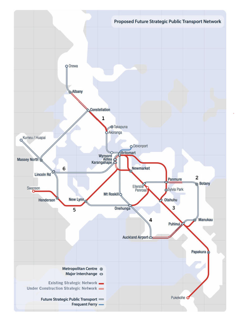
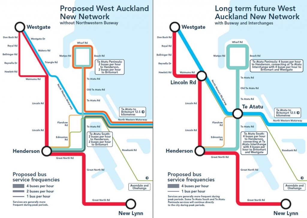
As shown on the map below of the current network plan, there is now also work underway on the much needed Eastern Busway at both ends, the Northern Busway is being extended and yay! the CRL. The incremental delivery of our network continues, but routes 4 & 6 are currently in Light Rail limbo.
Having four simultaneous projects of scale underway at once as we do now isn’t bad, but could both pace and efficiencies be improved by committing to deliver bigger parts of the missing network together?
That was clearly the thinking of the current government when announced it wanted to deliver the last two missing core radial branches (4 & 6 on the map above) of the network as one big project. Most likely in conjunction with some large foreign consortium. Where this plan is at, and whether it really is better to involve private financing for big transit projects is something we await further information on.
Because these two new lines are planned to be a new railway, to maximise the additional capacity and resilience of the overall network, and because they will share track on Queen St, it clearly makes sense to bundle them together.
Any new railway, of course, does need sizeable chunks to be totally finished, including a depot and vehicles, before any part is able to open. But still they are two big projects, and even if part of one deal, will still be delivered in sections. For example downtown to Mt Roskill distance is the same as the whole Wellington Station to Airport proposal. It is a decent sized project on its own. So it is reasonable to assume that even if both these routes were signed off together there would still be an element of staging, and all indications are the NW route will be later.
And this concerns me because the NW is in desperate need. Partly this is structural, there are no parallel direct transit routes to the outer SH16, unlike Dominion Rd with arterials on either side, both the old Great North Rd and the Western Line are kilometres away from the communities it serves. But it is also because the huge work to add extra lanes and the connection of Waterview has, inevitably, induced increased driving, so the thing infarcts on a regular basis already, despite being brand new. Lord knows what the model said was supposed to happen.
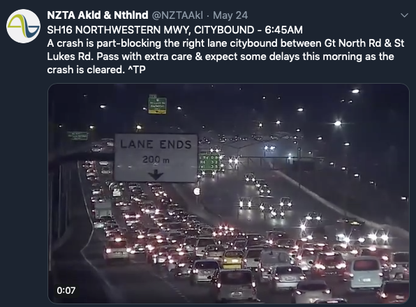
But most of all it’s because NZTA have just upgraded the motorway with only the most cursory public transport improvement. There are bus shoulders though these are also vehicle breakdown lanes, and in any case the shoulders disappear at interchanges and bridges. The results for bus users are predictably appalling: Todd Niall has been describing these failures at length in articles that should send senior NZTA people reaching for their ‘please explain’ buttons:
The real frustration is when the bus reaches the northwestern motorway at Westgate. NZTA territory.
NZTA also failed to include any bus stations, the key early additions on the Northern Busway, most importantly the two vital ones at Te Atatu and Lincoln Rd, despite these being requested by AT, and even designed. Matt has described all this a couple of years ago:
Yet despite the busway being a key project, it’s not being built at the same time meaning we’re going to have to go back again in just a few years and dig everything up again. Not building it at the same time as all of the motorway widening works is quickly shaping up to being one of biggest transport mistakes of all time.
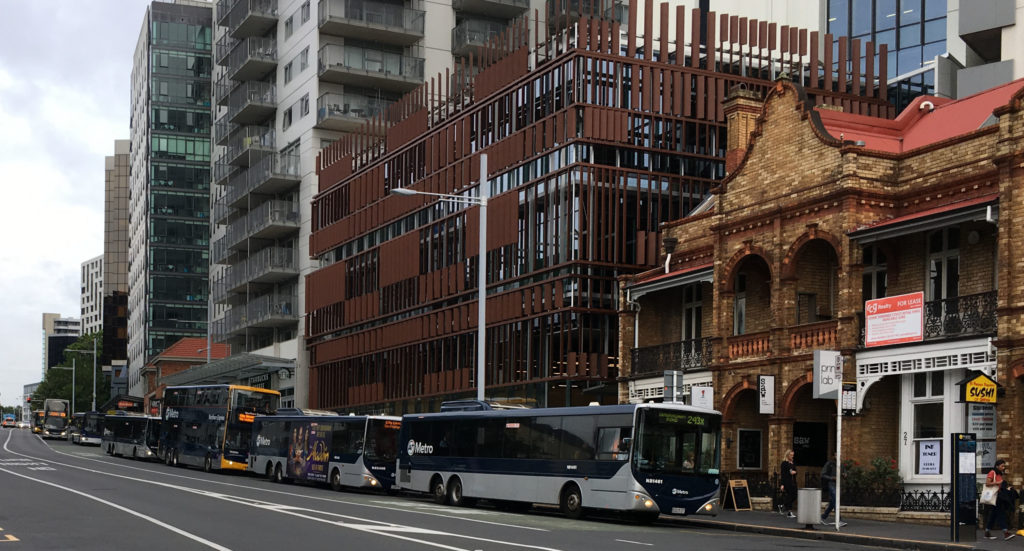
So this is where we are at. The Isthmus route is already fully staged with buses doing pretty much all they can, and tripping over themselves both there and in the city, though AT continues to improve intersections on Dominion Rd for buses and has added double deckers for more capacity. If nothing else we all should be concerned about the inefficiency of this:

Wall of 5 double deckers on Dominion

Upper Symonds St
Symonds St at the universities.
But the North West has nothing going on, which makes the communities out there the most underserved major area in the city, as the East, over the Tāmaki, the other most underserved major area, is on the incremental ‘constant improvement’ ladder of AMETI.
But this can fixed.
There is a very useful interim intervention that is essentially enabling works for LR, which should, in my view, be built while LR is being both planned and delivered. As described in AT’s 2017 NW corridor study.
This study recommended a busway over Light Rail for this route, despite very similar costs, for two reasons:
- Stageability, it is undeniably easier to add sections of busway while running buses on other roads. But Light Rail can be staged in this way too, by using buses, especially because of these can keep running unhindered on Great North Rd, Pt Chev to the city, while construction is underway in the SH16 corridor, and on the existing shoulders from Pt Chev outwards. And building LR for the Isthmus route on Queen St is building a stage of LR for the North West (This efficient interlining is one of the compelling reasons for building the NW as Light Rail).
- Because the scope of the study did not include the City Centre, so the problem of bus numbers there could be waved away along with the costs; bit of a study design fail it seems; this route doesn’t suddenly evaporate at Newton. Bus volumes in the city are becoming critical already, which Light Rail effectively solves by sharing the Queen St line of LR1, thus reducing volumes on Albert St from the Northwest, and Symonds St from Dominion Rd, and all the turn around and city staging space buses require.
By adding the key stations that NZTA should have built as part of the SH16 upgrade, just the chartreuse green section on the map below, and using the existing shoulders either side of here, and Gt Nth Rd from Pt Chev to the city:

The critical problem section of this route for buses now is between Lincoln Rd and Te Atatu. There is no way for passengers to join buses on the patchy bus shoulder lanes, as there are no stations, and in any case the shoulders disappear at interchanges, making the buses subject to congestion and far too slow. So adding just two full scale bus/LR stations at Te Atatu and Lincoln Rd and proper Busway/LR right of way between would make an enormous difference to the utility of PT here. Buses would then use existing bus shoulder lanes on the causeway to Pt Chev, and then the bus lanes on Great North Road to the city, as they currently do.
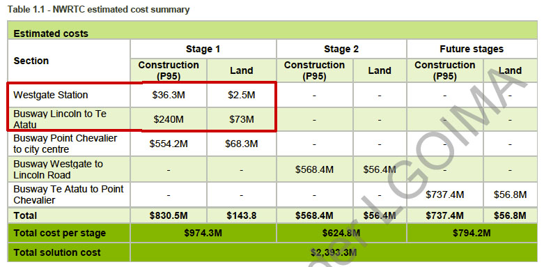
Interim works in red below, including stations at Te Atatu and Lincoln Rd, deleting the Pt Chev to CC as unnecessary, that section to be straight to Light Rail, so a total of ~$350m:
And these works all to be Light Rail ready. So this both incrementally improves service on the NW and builds a section of the future Light Rail line and stations early, and staging the construction of the ultimate full noise NW RTN.
And enables access to buses on SH16 and AT to run the proper New Network pattern as planned (right) with NW services like the Shore’s NXs:
The Northwest needs work, fast.


 Processing...
I recall being involved with the early scheme planning of the NW motorway upgrade. At that time ARTA decreed that rail would be the rapid transit mode from the CBD to the west. That strongly influenced the design of the subsequent upgrade works.
Yes, I’ve heard that at the time ARTA was very concerned that talk of busways in the west would derail the upgrade of the western line, so had a policy that the rail would be the only rapid transit for the west.
However that was quite some time ago, and well before the huge greenfields expansion around westgate, Hobsonville and Whenuapai was put into the pipeline… and also well before the current northwestern motorway works were started. They really missed an opportunity there, but until very recently the view of NZTA was “we only build highways” so they weren’t exactly struggling to find a good multimodal solution either.
The old west and the new northwest really are two different parts of the city, each of which justifies rapid transit.
Excellent plan, Patrick. The NWM is in a dire state. NZTA made mistakes that are impacting people’s wellbeing. The longer they leave it, the more impact those mistakes have.
Although I’d disagree that it is more important than Mt roskill. Northwest will be yet another transit investment with really bad walking catchment. Mt roskill will be our first rapid transit with decent catchment at all stations.
And really that’s the beauty of LRT knitted into the urban fabric.
The NW LRT along SH16 seems a waste.
Yes. And also why the best outcome the NW can hope for is to have as much in the way of local bus and active mode infrastructure within the NW, feeding to the spine that is in itself not knitted in well.
What would best enable that is reallocating some of those motorway lanes to light rail, as it has the additional effect of reducing traffic volumes within the NW, making the buses and active modes work better there. Whereas just adding LR to what is there doesn’t get this benefit.
A fast zippy line from Westgate until Pt Chev sounds great and could provide evenish access either side through this section. Would then meander along Gt Nth Rd, which psychologically would seem quite slow for those coming from far out wanting to get to the city then having to slow down at the end but perhaps is a good balance all things considered?
Looking forward to some proper business case design to see what they come up with anyway..
Not unlike the Northern Busway merging back in at the bridge, or when it started no priority on Fanshawe. So this would need to come with fixing the delaying points on GNR, like the disappearing bus lane at MoTaT…
What matters is the overall journey length which i’m confident can be significantly improved b fixing the worst sections.
It’s only seen as bad walking catchment in terms of looking at development as it stands today. If you factor in the Unitary Plan, and possible development (well, almost certain development) if LRT was built along the NW corridor, things will be looking very different. That development is unlikely to happen until there is a real transit line along there.
About 20 years ago a senior manager at Transit NZ told me they were going to look at what projects might be needed on the North western motorway. I asked why it hadn’t been studied yet and he told me it was because nobody in their Auckland office lived out that way. And yes he thought that was wrong as well.
Chiming in on the ‘Needs Work Fast’ sentiment: At the moment I think you can safely add 10 minutes to your commute at peak every six months.
Excellent piece.
Yes, West Auckland PT is a mess. Few if any bus lanes anywhere summed up nicely in the disaster that is SH16. If I recall correctly the supremely arrogant moron Gerry Brownlee stopped any PT addition to the North Western rebuild. National did it in the ’50s with the Harbour Bridge and true to their myopic DNA they did it this century just the same.
But now is now and we have the hapless and quite frankly useless Phil Twyford whose trajectory is on par with a 737 Max. What is needed now is a minister whose sole focus is on transport and most especially PT in Auckland. There is a cabinet reshuffle not far off and the PM MUST disconnect Twyford from transport, (because Christ knows housing is a fiasco under his leadership), and put a competent person in his place. Because Jacinda, if you are listening, Phil stands a better than average chance of losing his marginal seat anyway, deservedly, even if it is to the televangelist Alfy!!!!!!!!
Their focus should be laser-like on this and only then will anything be achieved.
But just to repeat, forget PT east of the railway in West Auckland, it’s awful!
Too harsh on Twyford, Waspman. Save your vitriol for the traffic engineer who gave evidence for why buslanes weren’t required, based on his modelling. Save it for the politicians at the time who were puppets for the automotive industry.
I think Genter should be the transport minister because she knows her stuff really well. But we just don’t get to see what sort of obstacles the political and bureaucratic machinery are throwing up in front of Twyford. Would you prefer Shamenoff Jones to be minister?
I obviously disagree Heidi. I think history is showing us that Twyford was absolutely comfortable as an opposition MP, great pay and privileges, never had to deliver anything of substance, just turn up and eat your paid for lunch.
The proof of which is Kiwibuild that is embarrassingly so far off it targets the be declared a total failure. He had 6 years to plan, build relationships, get the lie of the land both on the construction industry and the bureaucrats he would deal with. He did none of it. And housing is not just a festering sore, it’s a crisis in this country.
Next was transport. He didn’t just plagiarise Greater Aucklands blog musings on PT planning, he took it as policy lock stock and barrel during the build up to the last election campaign. What the hell was he doing before that?
This guy could take the piss out of the last government’s shortcomings but he had done NO homework on what the do should places be swapped.
He must have gone into a state of sheer panic when Andrew Little stood down with Labour facing yet another defeat and under Jacinda looked like winning. What a phony!
He is too weak to do what is needed for us and still way too over his head.
Please, Waspman, political opinion is welcome but not ad hominem attacks.
Let me put it more directly then. Auckland badly needs a transport minister who knows what they’re doing, to overcome the built in bureaucratic resistance to sort out the years of neglect that is our transport systems and quickly. We all know National don’t do anything but the private car and we cannot afford to wait a generation to have another go.
Twyford is not the solution, he is just another obstacle.
Thank you, that’s much more constructive. So now I’ll add that Twyford needs to do a crash course in the compact city, because he doesn’t understand that sprawl is the biggest source of problems. But I’ve seen the two wineboxes full of documents that ministers get delivered for reading every day. It’s a really hard job. The big political parties also have knives out for each other all over the show. For housing, I’d prefer to stick with him now that he’s been through a learning curve.
Genter should get Transport, but Twyford should stay in Housing for now.
It is a hard job, but you also need an ideology of sorts that no sifting through 1000’s of documents is going to fix. Right now, Twyford or rather the Labour Government do not seem to have an ideaologiy when it comes to Housing and Transport.
Both Labour and Auckland Council (to some extent with the Auckland UP) have the mandate to push PT to NW (and everywhere) and they have a mandate to build a compact city.
Putting Kiwibuild in Whenupai near 0 PT infrastructure. Not developing Kiwibuild on large apartment scale in Central Auckland where consents already exist etc makes me feel like they don’t quite have an idealogy..
Part of the problem is funding. Labour actually had the CFN as a policy platform. Which included LRT to the NW.
Given the CRL is costs more and it also supports the West, maybe less the NW. Then it is a very reasonable trade with the limited means of the existing budget framework to defer NW LRT plan and keep the CC2M LRT as the priority.
Twyford is also been weighted down by organisation culture issues within NZTA. Plus the Kiwibuild CEO didn’t work out.
Personally I don’t expected short term fixes for these problems.
Housing and Transport are 50 year investments.
Twyford is working in two areas where Labour is actually attempting a reasonable amount of reform, it is probably too many reforming roles for one person.
However, none of us really have a clue how effective he is in the background, he may well be exactly the right person to turn these ships around or he may fail. There is a huge risk in making change in that someone who is no more competent may have to start from scratch leaving us further behind.
JAG may well be very knowledgeable on the topic but none of us really know what her skills are at getting policy into action.
I think we just need a bit of time for some things to show. Twyford is pretty good if you ask me. Yes both transport & housing is a big ask but Nicolas Lee & Jezza say it’s no quick easy fix.
Agree. He’s way out of his depth.
Absolute disaster.
So is his boss.
you big men have the most convincing arguments….
@Master Chief there are better places than this to lob your unsophisticated attacks – why not try shouting at an episode of 7 Days instead? “I’ll get you for being mean to my adorable hero Simon Bridges” etc
And there it is Heidi showing her true “Green Party” colours. Genter would have everyone walk, cycle or ride a horse if she had her way taking us back 100 years (btw there were more fatalities per capita back then too).
The Planet wasn’t about to overheat 100 years ago, so sure bring it on.
Its amazing what ridiculous conclusions people will draw when blinded by political preference.
I say preference rather than ideology because these people would be surprised what they actually do and dont vote for when guided by a mere colour.
What’s that squawking noise – it sounds like “please confiscate my precious twincab so I can have the novel experience of not spending hours crawling on the southern motorway during the weekday peak”
Yeah we should tell the Dutch, Danish, Germans, Swiss, French, Canadians, Belgians, and Spanish that they are wasting their time with this cycling rubbish.
NZ, that well known bastion of transport innovation, has the real solution to urban transport issues. More and bigger motorways and more cars! Naive fools!
Great tongue in cheek comment 🙂
Perhaps our country needs a different solution than those ones you mentioned?
I’d like public transport to work in NZ but I think our challenges are vastly different to those countries. I’m not sure if NZ has the financial capabilities or the collective desire for public transport to be effective as other countries.
I haven’t seen anyone suggest we rip up the motorway. Next argument….
How are we going to get enough bus throughput on Great North Rd without disturbing the car carriers
+1
Might have to confiscate the front of the car dealers’ sections under the public works act..
Interesting post.
Will I still be sitting in SH16 congestion on Kumeu to Westgate to city in five years from now?. Can anything realistically change?
No, 5 years is not in the plan.
For about $5m they could have HR up and running to Kumeu/Huapai maybe even Helensville within a year using the existing infrastructure if they wanted. Doesn’t need to be permanent but anything is better than the existing situation and busway/LR are a decade away. Do HR until then same as Puke.
What’s everyone’s understanding of the word “dedicated”. Can a lane dedicated to buses be allowed to have “first and foremost” another purpose?
I ask because the BOI evidence for the widening of SH16 says it will “create east and west bound lanes from Rosebank interchange to Great North Road interchange to create five lanes each way and a dedicated bus shoulder in each direction”
Since those bus shoulders are ‘dedicated’ to buses, is it right that they should have another purpose that has a higher priority?
I think it has two meanings. A dedicated follower of fashion (oh yes he is) means someone who is devoted to fashion but can also do other things too. The second meaning is to be exclusively allocated which is probably what the bus lane thing was all about.
Definitely not the first, I guess… It will make or break him so he’s got to buy the best… we didn’t get that.
Hard to claim it is dedicated if another purpose trumps it even if broken down cars are less frequent.
I don’t think it is a big issue though. My understanding is that buses are only allowed to go 30kmh faster than the adjacent traffic in these lanes (god knows how they measure that!). On a typical journey they might deal with one or two broken down cars, reasonably easy to go around them.
I think it is safer to have these cars in the ‘bus lane’ where they can be negotiated by one professional driver every couple of minutes rather than tens of amateur drivers every minute.
The issue is that a peak, when the general lanes of traffic are not moving going around such broken car can take a few minutes, making journey time completely unreliable.
Heidi, I say don’t sweat the small stuff. Technically, is it a dedicated lane? Probably not, but does it matter? For about five years I have travelled in a bus in a shoulder lane. I can remember that only once was it blocked due to a breakdown.
The big question for me is, would I prefer an imperfect buslane, or none at all? The answer is simple.
Auckland’s climate change challenge is to really quickly get people out of cars. Realistically, rapid growth in the next five years will only come on buses given that there is only going to be one alternative available in that time frame, the CRL.
I note that Singapore has 4 million passenger bus trips per day so if Auckland wanted to scale up our bus fleet it is certainly possible.
And yet NW is the best bikeway in Auckland 🙂 Something in the transport space that they got right…
True. But only because the environment court made them! Though to their credit they are now adding cycling and walking to m’way projects without waiting to be order to be the courts. See Northern extension; both rapid transit and cycling and walking along with m’way supersizing.
Next step; drop the expensive wasteful traffic inducing and polluting part of the project, and just build the missing valuable parts….
Looking at the stations, they should also add a station on Rosebank off ramp.
The Rosebank business district is a major employment magnet. A lot of people would be keen to use that station to commute to work. This also act as an alternative station for people living in north Avondale.
Omitting it would be a major mistake.
Yeah, that would be nice. It’d make my life much easier. Apparently it just doesn’t have the numbers, though. And I suppose that makes sense with its geometry; long and thin.
That could easily be addresses by the Te Atatu station. There’s less than 1Km between Patiki Rd and Te Atatu on/off ramps.
But how can a connector bus access that?
Even if it can, there is still a 1km detour each way (2km total), which is a not really practical.
Walking? I don’t think many people would like to walk 1km on a windy bridge everyday.
The same way currently 138 runs – using Patiki Rd off/on ramps.
138 works if people are going from/to west.
However people going from/to city possibly put off by the detour.
It is still relatively cheap to build a small simple station near the rose-bank off ramp, and the 138 can update the route to stop at both Te Atatu station and Rosebank station.
That wouldn’t cost too much and enable Rosebank to support more business park intensification on its light industrial/business zoning.
Replying to kelvin (reply button seems to be gone under the post):
If you can make the bus run priority – it’s only a few mins longer to transfer at Te Atatu it’s still cheaper than another station, also bearing in mind the volumes going that way (and not via Avondale).
Adding a station in already incredibly difficult area (not a lot of space, on a swamp) is not going to be cheap. I guess it could be made to work over two levels, with some sort of structure above the motorway (between the off-on ramps), but that doesn’t sound cheap.
Transferring at Te Atatu isn’t too bad. Between Pt Chev and midway along Rosebank Rd, the options of changing at Avondale or at Te Atatu are usually about the same. The real problem is crossing Rosebank Rd between stops. In theory, you could do a loop to ensure you don’t have to cross.
I agree it’s a gorgeous location that is somewhat wasted. But I don’t think there’s any point to shifting industry out. Making it more walkable and safer to cycle, though for all the workers there, and with some nice pocket parks would be great. The huge trees by the service station at the intersection of Patiki Rd and Rosebank Rd have an incredible population of birds; fantastic bird play and call in the evening. People in cars possibly miss that. Slower and less traffic, with some nice bench seats would allow people to enjoy what’s there.
You could just catch a train to Avondale and hop on the 138 from the other end if you don’t like the doubling back.
I think the answer is that 138 bus as a frequent service between Te Atatu and Avondale.
A station at the end of Rosebank would be diabolical to try and provide bus, car and taxi access to , and practically useless for walk up catchment.
I think Rosebank can model Smales Farm.
There is a potential for TOD. Panuku and AT can put a station and build an array of office buildings near by.
The office would be attractive to prime asset because it has great public exposure to the motorway and sea, as well as good sea view.
That also has a good amalgamation effect as the office park can support with the rose-bank business precinct and vise visa. New fancy architectural office building can also upgrade the image of the old and dirty rose-bank heavy industrial perception.
Resource consent would not be any issue because the land is zoned for business and industrial. The local politician will support because it will increase tax and create job.
Te Atatu does not pose this opportunity because the surrounding land is zoned for residential. There will be many complains from NIMBY and it will be a political suicide.
Most of the area surrounding a potential TOD is the sea! It would be a hell of lot easier to rezone residential land at Te Atatu than try and rezone the sea.
jezza exactly. Royal Rd is much more needed; has a catchment.
A small station would surely be good here still though, not so much for catchment but purely as a hub. I guess the real lack at the moment though is that Te Atatu hub.
There is something I would really like to see. That is some artist renders of potential LR/RT bus stations at the various locations in the NW transit route. Also some motorway section render showing how an LR line/bus lane fits into the shared corridor. Over and under passes too.
As someone said in a previous post, renders go a good way to getting the proposed RT scheme looking more viable and raise the interest of many people who otherwise cannot envisage new transport infrastructure. Just those renders of the Puhinui interchange demonstrated.
Is it too early in the big scheme of LR for nzta/at or anyone else to have considered or funded such artwork?
The existing bus lanes between Te Atatu and Pt Chev also would have to be re-configured. Currently there’s a huge gap westbound, that starts about 400m before Patiki on-ramp. Also having two (3 including the bus shoulder) off-ramp lanes at Te Atatu makes it really difficult for ‘through’ buses – they basically have to either be stuck in general lanes or cut across 2 off-ramp lanes.
What I really dislike about those ‘bus shoulders’ is that if there’s a breakdown at peak they’re being used to store the broken car. That basically makes them completely useless. They should be exclusive to buses during peak. Somehow we survived through the years of constructions with no shoulders at all.
That’s Heidi’s point about the word ‘dedicated’ she’s basically saying the design as built is in breach of conditions as the lanes are clearly not dedicated.
Yes, that’s what I’m referring to above. The AMA have replied to my OIA on the topic that the shoulders are “first and foremost emergency stopping and breakdown lanes 24/7”. How can it also be true that they are “dedicated bus lanes”?
I think the NZTA has managed to have its cake and eat it, too.
Which can probably only be fixed by saying that the bus shoulder lanes are not emergency break down lanes, that emergency break downs must stay out of them, and the cost of treating those parts of the motorway with the sort of urgency that they use in areas where there are no shoulders – eg the Harbour Bridge – needs to borne by motorists from their fuel taxes.
How else can both modes have the benefits that come with provision of a dedicated bus lane?
What is the standard for supplying hard shoulder/emergency on roads? Some motorways dont seem to have them and some do. The reason I ask is the Hutt Road has them but no cycle/pedestrian facilities in some places and personally I think emergency shoulders are less important.
I don’t know… and agree that the protected cycle and pedestrian facilities are more important.
The harbour bridge has managed all it’s life without emergency stopping lanes. The alternative may well mean more intensive monitoring and additional costs of rapid response vehicle removal but I am sure these are cheaper then dedicating extraordinarily expensive real estate for vehicle breakdowns
Yes, it bugs me that over the years the rail system has been forced to pare back on contingency-measures like crossovers to allow emergency wrong-line-running (not to mention extra loops, 3rd+4th mains etc), and yet the expectation is that motorways should routinely have an extra lane each way just for contingency.
There’s no shoulder on SH1 all the way from from the Harbour Bridge to Ellerslie.
It’s clearly an optional ‘nice to have’ when it came to the bridge, the St Marys Bay widening, the VPT project, the CMJ widening, the Newmarket viaduct, the Greenlane widening… in fact every motorway project in the last 20 years has happily used the shoulder up for more traffic lanes.
Question is will the apply the same when it comes to rapid transit?
The Hutt Road has emergency lanes? If so then they are pretty patchy, at least going northbound between Ngauranga and Petone. These “lanes” are also the northbound cycle lanes and in places they narrow-down to about 1-1.2m wide between the live-lane and the tarseal-edge (i.e.the drainage-ditch along the cut face of the escarpment). Definitely not wide enough at these points for any vehicle to stop on without encroaching on to the live-lane also (as well as blocking the cycle lane and forcing cyclists out into the 100Km/h traffic). Situation is better on the southbound side, but along most of this side there is the separated cycle lane too (also pretty rough and narrow in places, but at least separate from traffic).
‘Enahanced bus shoulder lanes’ 🙂
Great post, staging it, with this early intervention would really give good bang for your buck.
Rather than talking about tunnelling Dominion Road or Queen Street for the sake of it, can they not tunnel under and around Waterview interchange popping out onto Gt North Road? Thats just as fantastical as other tunnelling proposals thus far…
Tunnelling Queen st (north-south) or Dom rd are crackpot schemes in the minds of fools. Anyway both are predicated on the absurd premise that vehicle traffic must retain total use of these streets. Which is to deny part of the point of the project; to replace car trips. Both are entirely unaffordable as well as undesirable.
Not fools Patrick, Simply those who appreciate that rapid transit (be it HR, LRT or BRT) and narrow-ish residential streets do not mix particularly well, even without general traffic. The current speed limit of 50Km/hr is too fast for Dom Road type environments. 30Km/hr is more appropriate and I predict we will increasingly be seeing this implemented. Where does that leave “rapid transit”, other than underground, elevated, or on a fully-fenced route somewhere else?
Everyone overestimates the impact of top speeds, it’s a critical part of windshield bias, because car journeys are actually heavily effected by top speed. Even if all of Dominion Road, from Valley Road to Mt Albert Road were subject to a 30 km/h limit instead of 50km/h, the absolute maximum possible increase in journey time is 3 minutes. It will be less as the timings already include over 600m of acceleration or deceleration where the vehicles will be doing no more than 30km/h. Most likely, 30km/h limits would only be implemented in the town centres, where the stops will be. It would also be perfectly reasonable for the much lower volumes of track guided vehicles 5m away from footpaths to have a higher speed limit than the manifold unguided vehicles nest to the footpath.
Also, Dominion Road isn’t narrow or residential, which road are you talking about there?
What governs the speed on Dom Rd in any vehicle is the intersections. There is very little opportunity to get up to 50 mph anywhere. Not we expect that limit to drop, outside of centres anyway.
And Dave yes fools. Because if you wanna hold out for a tunnelled or elevated system here you’ll be stuck in buses for ever. Elevated is unconsentable away from a motorway corridor and tunnelled is unaffordable outside of relatively short city centre sections… we have a network to complete, we cannot, nor need not, build 10s of kms of CRL!
@ Sailor Boy: Yes, this depends on stop-spacing.
A 1Km section between stops with accel/decel at 1.0m/s² has the following transit times:
50Km/h max : 86s
30Km/h max : 128s
. . Difference: 42 seconds
A ½Km section between stops with accel/decel at 1.0m/s² has the following transit times:
50Km/h max : 50s
30Km/h max : 68s
. . Difference: 18 seconds
Every such section at these stop-spacings would cost these time-differences between 50 and 30Km/h. Your stated 3 minutes over the stretch that you mention is believable.
– – – – –
@ Patrick
What those of us who are not fools (but see things differently to you, if you will allow this) are advocating is non-rapid transit (street LRT) serving Dominion Road, and true rapid transit (HR on own r.o.w.) taking an alternative route to the airport, by whichever route can optimally be achieved. I see the proposed BRT-connection to Puhinui as merely the first stage in the process.
Those advocating tunneling Dom Road – fools perhaps, though I challenge you to think of a less-disparaging adjective.
Elevated – may be not so foolish if appropriately-done. https://upload.wikimedia.org/wikipedia/commons/8/83/Le_viaduc_%284738407837%29.jpg
Don’t rule it out. It happens all over the world.
If the imperative is there then such things will happen.
Why rule anything out? But I won’t be wasting a millisecond on lobbying for elevated down Dom (place destruction), or tunnelling up Queen (unwanted and unaffordable).
But also the point of difference here is you see no value in surface rail. I see (and have experienced all over there world) huge value. Especially because it removes vehicles from dense centres. Only if cars must retain priority is surface rail second rate. And no one is proposing that.
Access to the Airport is not nearly as much of an issue as those opposing LR seem to think it is. Auckland will have three high quality Transit options to the Airport: 1. Rail via transfer at new station designed expressly for that from fully 2/3 of all trains on high frequency (way better than an infrequent express from one station) 2. Direct Botany Line. 3. Direct LR all from the city and passing through densely populated new catchments on the way.
People come from all over for the Airport; it is the whole Network that’s the key, not one route for downtown suits.
Transit to the Airport is going to be so rich, and convenient, from many more parts of this big city than any downtown express could ever offer. And anyway the speed of these options will be hardly different from any direct train.
But aside from that, we know what tunnelling in Auckland costs (and therefore we can’t do a lot of it), and we know elevated (also expensive) is an option only in certain places, so Light Rail offers a complete whole Network in ways that these expensive engineering solutions don’t.
And, realistically, anyone who successfully opposes LR on these routes will just be getting more buses, a lot more buses. Not some even more expensive form of rail. LR is only rail option for the Isthmus; there is no other possibility than a bazillion buses.
It is clear that the growth in ridership ahead, esp until CRL opens will be on buses (check the chart). LR offers the only chance to convert a sizeable chunk of that future growth to rail. Of course the current rail network will grow ridership well, post CRL will boom, but that will be new riders along its existing catchments, plus bus transfer esp from east Auckland.
AKL does need a 2nd railway to complement this and the only possible one, the only one that can be delivered at scale, is a surface, and in part road using, one. Which happily exists and succeeds in cities all over the world. Bring it on.
Sorry if I have not made myself clear. I *do* see value in surface rail:-
“. . advocating non-rapid transit (street LRT) serving Dominion Road. . “ = surface rail
“. . .route to the airport, by whichever route can optimally be achieved. . “ = surface rail
I am not one of those people (fools?) suggesting tunneling Queen St or Dom Rd. Neither am I advocating airport expresses. But I am advocating putting all transit that we want to be rapid, on its own, exclusive right-of-way. 1st preference is at ground-level, fenced. Elevated/tunneled only where unavoidable or distinctly advantageous. And if HR ever does make it to the airport it should be as an extension of the existing Metro service as per Sydney or Brisbane, not a fancy Heathrow Express type thing.
“putting all transit that we want to be rapid, on its own, exclusive right-of-way. ”
That’s exactly what is proposed for the airport LRT line. It’s own, exclusive right of way.
But it’s not Nick, because on Queen and Dom, pedestrians can meander all over it. That’s not what I call an exclusive right-of-way.
And that’s fine for slow transit but not rapid transit, at least not by most people’s definition of it.
Dave B: “A 1Km section between stops with accel/decel at 1.0m/s² has the following transit times:
50Km/h max : 86s
30Km/h max : 128s
. . Difference: 42 seconds
A ½Km section between stops with accel/decel at 1.0m/s² has the following transit times:
50Km/h max : 50s
30Km/h max : 68s
. . Difference: 18 seconds
Every such section at these stop-spacings would cost these time-differences between 50 and 30Km/h. Your stated 3 minutes over the stretch that you mention is believable.”
That section is only 3.5km long. Your own maths shows 2minutes 6s lost at 1/2 km stop spacing. Even at the ludicrous 1km stop spacing, you lose less than 3 minutes over the longer distance of 4km. Thanks for doing the maths on stop spacing though. It saved me a lot of effort and strengthened my point.
Sailor Boy, 3.5 km long? That’s a bit misleading. The on-road section from Wellesley to Denbigh Ave is 7.0 km long.
It’s gonna be a 20 min trip at 21 km/h and that’s good. At 35 km/h it would be 12 mins and that would be impressive.
And elevated rail, in any form, mono, light and heavy
Patrick is the chart of the Auckland Harbour Bridge – vehicles or people?
It is vehicle counts. The bizarre thing is that vehicles fell prior to the busway opening and then increased after. The lesson seems to be don’t build busways!
I think the flat peak indicates that vehicle volumes have reached the natural limit of the bridge. Numbers of people would be an interesting stat in comparison.
Prior to the busway the lines would probably track. I think the people per day is still increasing after the busway.
miffy, cute, but if you read the text you’ll see that the bus stations, with shoulder running, started in 2005, exactly on the inflection point, which is rather a key detail of the post.
NZTA surely know, this is after all their bit of kit, that it was the stations AND shoulders, not just intermittent shoulders, that made the buses on SH1 North of the bridge start to be useful enough to be an option for drivers. And therefore help relieve the pressure on their m’way.
We can probably surmise that people do indeed need a means to get onto buses on a m’way… I guess the average NZ traffic engineer might be forgiven for not having the slightest clue how people might access anything without being in a car, but as NZTA have had over a decade of watching the Northern Busway, with stations, boom, you’d have thought someone in the building might get it? Especially with AT banging on at them to include the things…?
Here, from the report, is a little explainer, about buses and motorways. Cos people often seem to think if there’s a motorway there then that’s all that’s needed for cars and PT alike. But no PT needs its own infrastructure quite unlike a motorway to actually work effectively and to work efficiently:
Then there’s the additional point that that no one actually wants to go to a motorway, it’s just a boring part of the way to somewhere worthwhile, even in a car. And the very presence of the motorway is a hinderance to any place nearby being worthwhile. But because motorways are pretty much the only corridors we have left we do in some cases have to try to make them functional for Transit. Which means a whole lot of investment in stations, ped and bike bridges, feeder bus services etc… otherwise we just get a bunch of useless stations like Remuera, so cut off by the m’way it doesn’t attract users.
Sorry to rain on your parade Patrick but the big drop coincides with the opening of the Greenhithe section of the SH18 motorway and the completion of the duplicate Upper Harbour Bridge. Constallation Station and Albany Station did open as bus stops in 2005 but the other stations opened with the busway after the decline.
Speaking of raining on parades, the Upper Harbour Motorway opened in December 2007, just a couple of months before the Busway officially opened. This doesn’t appear to line up with the drop either.
“Having four simultaneous projects of scale underway at once as we do now isn’t bad, but could both pace and efficiencies be improved by committing to deliver bigger parts of the missing network together?”
Excellent question Patrick and the answer of course is yes, climate change amelioration demands it. There may be good news that the government suddenly has money to throw at it https://www.stuff.co.nz/business/113285880/new-accounts-show-surplus-could-be-billions-larger-than-expected-in-budget.
(My theory is that this is some of the money that fell into Stephen Joyce’s budget hole and it has somehow bubbled back to the surface).
The answer to whether any extra spending occurs lie completely with the desire of AT/AC and the government to effect real change. The option is available for them to declare Mill Road and Penlink projects that will only occur if they are funded by tolls.
As a Takapuna resident I was asked last year whether I wanted to pay a targeted rate to advance the reconstruction of Lake Road. (I politely declined as the only things more traffic on Lake Road will achieve for us is: more congestion in Takapuna; more emissions and pollution; and potentially the loss of our buslane. Not much to like!) Maybe the likes of Lake Road should be tolled if residents really want improvement? I note that Devonport is one of the suburbs most at risk by climate change.
Patiki Road needs a station as well. A lot of traffic that heads to the Patiki Rd / Rosebank Rd area originates from the east. To ignore this would be silly. Keep in mind the golden rule “If you want to be sure you’ll have good transit, be on the way from one transit destination to another – J Walker”
The downside of building Te Atatu to Lincoln Rd as a busway is the land required for stations. Busway stations require wider spacing to allow for through running. Now this may also be advantageous for LRT express services further down the track but, in terms of land use, the Te Atatu location has already been very well worked over by the motorway upgrade.
Busways don’t have to have that. If you chose to run a single mainline service pattern they would have to pull over at stations. In other words, you could run it like a train line if you wanted to.
Yeah, not discounting that. Was just thinking in terms of Northern busway station design. We tend to build big here.
The original Te Atatu location at Titoki Street is now having 36 one and two bed units built on it anyway.
Any busway will need to be on the southern side of the motorway. The motorway has been built hard up against the Rugby League fields and the northern corridor boundary along the causeway.
Seems old business case plans or something I have are on the southern side anyway then shoulder lanes after (heading east) Lincoln Rd.
Ignoring Rosebank and Patiki would be utterly boneheaded. West bound in the evening a huge amount of traffic joins the motorway at Patiki only to get off again heading to Te Atatu South. I can’t help but also think the occasionally proposed bridge across the Whau from Rosebank peninsula to Hepburn road (the most logical mid point to my mind) would take a big load off Te Atatu Rd that doesn’t need to be there.
Don’t think it’s that obvious it needs at station, as per Nick R above somewhere you can run the 138 bus as a frequent service between Te Atatu and Avondale, it’s only a bit over a 1km on a busway to the Te Atatu station, wouldn’t take long.
That assumes all people heading to Rosebank Rd are coming from NW.
No reverse back on a the reconfigured 138. If going to the city from Rosebank grab a main busway service. Will be grade separated speed remember.