Tēnā koutou, he rāmere anō. Friday’s weekly roundup here again.
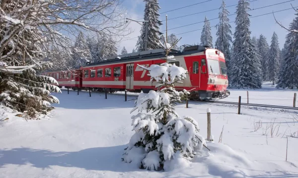
Heater image: not in fact Te Wai Pounamu during this week’s cold snap, but a train in Jura, Switzerland, from The Guardian.
The week in Greater Auckland
On Monday, Matt wrote about AT’s new (and yet old) plans for a cycleway along Rathgar Road in Henderson. Feedback is open until 14 October.
Tuesday’s post was, of course, about the shock announcement that Kiwirail and AT are planning a series of massive shutdowns on Auckland’s rail network over the next two to three years. This post is fast becoming one of our most-commented and viewed.
On Wednesday, we shared a guest post by Nicholas Reid about his complete map of Auckland’s 2025-ish rapid transit network, a glimpse of what a functioning transport network could look like.
Yesterday, we followed Tuesday’s post with a summary of reactions to news of the rail closure, and new information that emerged during the week.
It’s election week
You know what that means…
Vote for the good of Auckland!*
If you’ve got your voting papers, fill them out and get them into a voting box before midday tomorrow.
If you don’t have your voting papers, you can do a special vote. Go to a council service centre, get your special voting papers, fill them out, and drop them in a vote box right there and then.
It’s now too late to put it in a post box, so make sure you find a VOTE box!!
*And for our other towns and cities, if you’re an out-of-town GA reader.
If you’ve got friends who you know haven’t quite gotten around to voting yet, why not organise them into doing so by buying them a coffee next door to somewhere they can get their papers sorted? It’s what friends do.
https://twitter.com/ilovetheeconomy/status/1577763996081754112?s=46&t=Y4_MhBxKL9vB8LDuSrU7Vg
In a timely reminder of why these elections are so important, Dr. Timothy Welch writes about the role Mayors played in turning Copenhagen into the people-friendly, cycling city is is today.
Copenhagen didn’t build its brand as a cycling-friendly city overnight. They slowly constructed cycle tracks in bits and pieces over a couple of decades, and enshrined the ideas of a multimodal city in two planning documents: the 1997 Traffic and Environment Plan and the Cycle Track Priority Plan. And most importantly, its residents elected city officials with the will to implement these plans.
The next Auckland mayor will hold the reins as the city works to implement its climate obligations, its efforts to eliminate road deaths and address broader issues of housing affordability and the economy.
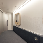
A majority of council candidates support climate action, reports Mark Daalder on Newsroom. A survey of over 1500 council and mayoral candidates across the motu got 600 responses, and over half of those were in favour of doing more to reduce emissions in their area.
The candidates were questioned about their stance on things like sustainable transport, housing density, managed retreat, and declaring climate risk.
Getting around Tāmaki Makaurau
…is about to get a little easier on the inner city ridgeline, with the Great North Road improvements beginning soon.
But we’re not getting across the Harbour Bridge anytime soon, nor are we getting anywhere else with the $695m that was, for a brief moment, going to plug that gap.
As Thomas Choughlan reports, we might find out where the money is being reallocated to in the next month, and there are fears that it could end up covering cost overruns on NZUP roading projects. Watch this space.
Green Party transport spokeswoman Julie Anne Genter said the Government should reallocate all of the funds to other active transport projects like walking and cycling improvements.”It is the minimum they could do,” Genter said.
“The New Zealand Upgrade is a significant investment in transport. If the Northern Pathway is entirely reallocated to highway projects, which have been blowing out in cost, that will influence how carbon-unfriendly the package is,” she said.<
The week in flooding: aftermath, and bracing for more.
There are absolutely horrific scenes from Florida where entire communities have been flattened by Hurricane Ian, which was still blasting the state’s coastline when last week’s roundup went out. Over one hundred people in Florida lost their lives in the storm and hundreds of thousands of households are without power.
Before and after of the Fort Myers Beach Pier pic.twitter.com/rT6zWXjQR4
— Sean Breslin (@Sean_Breslin) September 29, 2022
Australia is bracing for potential record rainfall across the continent this week, which will put pressure on places that have already suffered severe flooding this year.
Much closer to home, a particularly vicious pothole in the Kaimai Ranges took out dozens of cars in one evening. Potholes, the BoP Waka Kotahi Sytem Manager explains in the article, are often the result of heavy and persistent rain. A pothole is a humble example, perhaps, but helps describe a more unpredictable world in which we find ourselves at the mercy of the weather – and have to rely on one another to get out of sticky situations.
Getting people around
What does public transit look like in a post-COVID-19 world? Transit blogger Reece Martin explores that question in his Substack newsletter this week, arguing that it’s time to move on from the focus on peak hour trips, and spread services throughout the day to better meet the needs of more people and changing travel patterns.
During the worst periods of the pandemic, peak ridership was hurting a lot, and even now that things have returned to normal in a lot of ways peak ridership is still nowhere near where it previously was, and if Toronto’s GO transit (among many other systems) is anything to go off of; off peak, weekend, spontaneous, and occasional travel have truly surged (for GO specifically, weekend ridership has exceeded pre-pandemic highs).
The Minneapolis-St. Paul Transportation Happiness Map looks like an interesting tool. Researchers used smartphones to map people’s mood, how they were travelling, and when. Using the online map, findings can be broken down by mode and time, or aggregated to see patterns across different variables.
All together now: everyone loves trains
We spent the week wishing we’d been at InnoTrans 22, did you? Germany’s a bit of a journey for us, but thanks to the magic of the internet we were able to enjoy some of the highlights.
InnoTrans 22: Stadler and https://t.co/iYcLf2grsj Present First FLIRT Akku Battery-Electric Series-Produced Vehicle https://t.co/sAzW5fHqmq #news #rail #trains pic.twitter.com/VkmUYNlAUD
— Railpage (@railpage) September 22, 2022
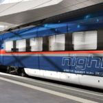
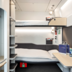
In Austria, ÖBB and Siemens Mobility revealed their latest NightJet carriages, which are full of innovative comfort solutions designed to entice passengers out of the air and into the sleeper train.
“With the new Nightjet, we are making an important contribution to making rail travel more appealing and to achieving climate targets. The trains are highly innovative: they will be the global benchmark for years to come, and they stand out due to their comfort for travelers and their sustainability and flexibility.
Melissa and Chris Bruntlett, of Modacity, took a tiki-tour to one of Europes quirkiest transport curiosities: the Schwebebahn of Wuppertal, a suspended railway that is not just the cutest thing you ever saw, but an integral part of the city’s transport system – a legit elevated metro line through the guts of the city that carries 25m passengers per year.
On behalf of transportation nerds everywhere, today we made a long-overdue pilgrimage to an unlikely corner of western Germany.
Opened in 1901, the 13.3-kilometer Schwebebahn is Wuppertal’s electric suspended railway; the oldest—and probably most famous—of its kind in the world. pic.twitter.com/6z4zNxgvNT
— Melissa & Chris Bruntlett (@modacitylife) October 1, 2022
And because it’s been a particularly bad week for trains in Tāmaki Makaurau, perhaps this soothing travelogue of a train trip through the Swiss province of Jura will give you something to dream about instead.
“We have our own way of doing things,” says my fellow traveller. “We even have our own rail operator.” Les Chemins de fer du Jura is a company with strong local values that offers bus and rail services throughout the Jura. It’s an area blessed with excellent public transport, and slow trains and bus services are the perfect way to enjoy the rhythm of life here.
E-micromobility vs E-vehicles
E-scooters took the world by surprise, everywhere. Remember when the very first Lime scooters appeared in Tāmaki in 2018? Most of us thought they’d be a passing fad that would quickly go the way of Onzo bikes. Not so.
A new OECD report says Irish transport policy needs to shift its focus from e-vehicles to micro-mobility like e-scooters and e-bikes, as well as public transport:
“Car-dependent systems make rapid electrification slow and difficult, by locking-in large and growing vehicle fleets,” the report stated.
“Even with improved (and fully-electric) vehicles, they also fail to reduce life-cycle emissions, address accessibility gaps and other negative impacts such as air and noise pollution, congestion, road injuries and fatalities.” It added that incentivising electric vehicle use may “also reinforce car-dependency, further locking the country into a system that fosters growing car use and emissions by design”. Instead focus should be placed on public transport, and shared forms of transport…
The report recommended that a “systemic, electric and integrated” roll-out of micro-mobility services – electric bikes and scooters- by 2030 in Europe, to the point that these would account for 50% of all trips under eight kilometres.
The benefits would extend to public space and better land use:
A shift away from private cars would mean that people travelling to work don’t need to leave their vehicle parked and unused for most of the day, the report continued. This would massively reduce the amount of car parking spaces needed and would allow for more public spaces and compact cities.
“Modelling a systemic roll-out of micro-mobility across Europe showed that it could liberate 48,000 hectares of inner-city land (the equivalent of about 4 times the land area of Dublin).”
And, to add to the evidence that cities with comprehensive protected cycling infrastructure keep people in all transport modes safer, new research confirms policy for e-scooters needs to include a safe protected cycling network. AT needs to pick up speed.
How’s this for flow and efficiency? 50 bikes in 25 seconds.
Over 50 cyclists crossing and clearing an intersection within 25 seconds. Now try that with cars… pic.twitter.com/bRAetmtewI
— De Filmende Fietser (@FilmendeFietser) September 30, 2022
Cities to live in
Play streets for kids are the ultimate outcome in a liveable city – and opening streets so that people can reconnect is a core tool in efforts to make neighbourhoods safer and communities stronger. Play streets aren’t a new idea at all: there were once 700 in the United Kingdom.

A local, walkable, accessible city is a liveable city, too. A deep-dive on Forbes explores the way the ‘fifteen-minute city’ concept has become a rallying cry for progressive urbanists all over the world. The fifteen-minute city, or versions of it, have become cornerstones of public transport policy in many cities.
One of its most powerful applications has been in Paris where mayor Anne Hidalgo has used the concept as the basis of an enormous programme of transport transformation and mode shift.
[Professor Carlos Moreno’s] motivation for developing the model was to disrupt the traditional car-focused approach that dominates urban design thinking, and replace it with one focused on “hyper-proximity”. Not only, he argued, would this result in huge emissions reductions, it would also lead to more sustainable, human-centric urban environments. There’s a growing body of evidence that suggests such neighborhoods promote everything from social cohesion to public health.
And you’re all up-to-date with the Quarter-Hour Paradise campaign out of Wellington, making the case for a right-sized, climate-friendly, human-scale new Kiwi dream? Check it out, not least for the before and after renderings of what could be.

A liveable city also has clean air that’s safe to breath, and London’s Low Traffic Neighbourhoods look like they’re doing their bit. Data gathered from the pilot Islington LTNs, which were mostly implemented in 2020, shows that pollution has stayed around 2020 lockdown-level lows.

Islington now plans to install LTNs across the whole borough by 2030. Fun to see the main response is: please can you do it a bit faster?
Islington council is setting a KPI for the whole of its borough covered to be covered by LTNs (so removal of through traffic from minor roads) by 2030. To meet it they will probably need to deliver at least a couple on average every year https://t.co/EISd33mLwo pic.twitter.com/HtdqEaNCJB
— Jon Stone (@joncstone) October 6, 2022
It’ll be fascinating to see a first-order objection to LTNs – that they just divert traffic to boundary roads – melt away, as a whole area becomes integrated and people discover other ways to make short trips.
In the meantime, worth noting this immediate positive effect on the boundaries of low-traffic areas:
100% agree. My nipper's walking route to primary school along a main road (A4040, Howard Rd, Bham) was made infinitely safer when it became a boundary/distributor Rd of an LTN. Side road junctions went from lethal to safe. Started walking unsupervised@LisaTrickett41 @David4BKH
— Jim Smithson (@BoredBrummie) September 29, 2022
It’s also excellent to see London’s municipalities helping citizens get up to speed on low-carbon and low-cost travel, too. The wording and the approach from Lambeth Council could work just as well here for communicating our own Big Shift. Someone want to tag a transport minister?
https://twitter.com/lambeth_council/status/1577677258726248450
And perhaps now the borders are open again, our local leaders could take some well-planned trips and check out how it’s done? Mayor John Bauters, who we introduced you to last week, is having a wonderful time exploring some pretty liveable-looking squares, streets and plazas in Europe.
Ghent, where he’s eating ice cream in this video, is famous for its low-car mobility plan, which it implemented literally overnight in 2017.We have the world-class ice cream already; can we have the rest of this scenario, as a treat?
https://twitter.com/JohnBauters/status/1576685432560971778
And then our leaders could hop a train to Paris, and see how much can be achieved in a single electoral period. Goals.
https://twitter.com/citycyclists/status/1578087368292061184
The apocalypse looks like a traffic jam
A scene from our nightmares evolved in the Westfield Newmarket carpark this week. So many people tried to leave the carpark into Newmarket congestion at the same time that some drivers spent hours stuck in the queue.
Sandra Macaulay and her friend left the mall at 3pm, as she needed to drop her friend at the airport.
By 3.10pm her car had barely moved, so Macaulay told her friend she would need to grab her bags and catch an Uber if she didn’t want to miss her flight to Wellington.
“By the time she was in the Uber, I’d gone forward about two car park spaces.” Macaulay was still in the car park by the time her friend reached the airport. She eventually got out at 5.25pm, after almost two and a half hours of queueing.
Tauranga City Council’s commissioners have voted unanimously to remove free carparking – which was introduced as a trial when COVID-19 struck – from the city’s streets.
And in Hamilton, multi-storey apartments could be built on an existing carpark. Residents of the ‘heritage’ neighbourhood of Claudelands have some concerns…
Congestion charging is slowly churning its way through parliamentary processes – but it’s not going anywhere fast. While its unlikely we’ll see congestion charging in Auckland before CRL opens, the policy does, at least, seem to have cross-party support.
The report, which suggested possible charges ranging from $1.50 to $3.50 in peak times, found implementing a congestion charging scheme in Auckland could result in an 8-12% improvement in network performance, similar to school holiday traffic.
In its national strategy, Te Waihanga, the infrastructure commission, recommended immediately removing legislative barriers to congestion charging, noting that pricing was one of the greatest changes NZ could make to the infrastructure system.
Meanwhile, we’ll be able to collect examples of other cities that are making congestion charging a core plank of their transport decarbonisation plans.
From today Milan (Italy) is banning 25% of the most polluting cars in the metropolitan area from driving within the municipality.
It will be enforced with automatic number plate recognition cameras and vehicle tracking devices. Fines between 150-650€. pic.twitter.com/mOP8ZgtUqN
— Giulio Mattioli (@giulio_mattioli) October 1, 2022
Interestingly, today in response to news of an inevitable rise in the direct consumer cost of fossil fuel, the NZ Automobile Association is encouraging people to drive less – and in particular, to walk rather than drive for short local trips.
There was not a lot that individual drivers could do to ease the pain at the pump, other than avoiding small unnecessary car trips, said [AA principal policy adviser Terry Collins].
“Spring and summer are coming so get out of your car and walk down to your local. Other than that there is not a lot you can do.”
Sounds like a recipe for healthier and more social cities, not just for easing the household budget. (Top tip: a bike will get you three times further in the same time, or down to the local three times as fast. Talk about options!).
Things to chew over this spring weekend
“If we don’t do the impossible, we’ll end up with the unthinkable.” GA readers who are interested in future solutions and systems thinking will enjoy this excellent episode of a podcast called Futurenauts: The Future of Systems with Michael Palwyn. The good stuff kicks in around 12 minutes, and it gets particularly quotable at the half-hour point. The perfect listen while walking down to your local.
Speaking of future systems, we’ve been interested in the idea of citizens assemblies and participatory democracy for a while now. Dr. Tatjana Buklijas published a guest post on the topic for Greater Auckland last year, and this week she wrote about the history of participatory democracy in the wake of a recently completed project she developed with Watercare.
What distinguishes the deliberative process in Aotearoa New Zealand from those held internationally is respect to obligations enshrined in Te Tiriti o Waitangi and the rights of the mana whenua holders. Our approach included involving the Mana Whenua Kaitiaki Forum, through Watercare, in preparation of the process; respecting tikanga during the process; inviting Māori experts to address the assembly; and, generally, ensuring that te ao Māori perspectives were considered alongside the engineering, environmental and regulatory perspectives presented to the assembly.
And some things to enjoy
Here’s an epic intercity journey: two primary school aged boys ride a pony and cart hundreds of miles to get to the 1967 Montreal World’s Fair. It’s a true story, and you can watch a short documentary about them on the New York Times.
Staying in North America, this drone footage of the Chicago Cubs stadium is a must watch – and it’s a great argument for surrounding stadiums with urban life, not carparks.
https://twitter.com/JoePompliano/status/1575875016436207618
Back at home: head to Aotea Square on Saturday or Sunday to experience this weekend’s Diwali festival. Queen Street will become a festival street for the weekend, and will be closed to cars between Mayoral Drive and Wellesley Street. Enjoy some streets for people, people!

PS Vote!!
Ka kite, have a great one 🙂

 Processing...
That Battery EMU – no mention of range.
But seems like the kind of thing we should buy for Hamilton to Auckland so that it can get into Britomart. Maybe it can charge in Hamilton inside 10 minutes etc and then use the battery to get to Tauranga as well?
Stadler EMU operating in Schleswig Holstein has an in service batt range of 224km. Easily plug Puke-Ham gap until strung up, and extend beyond the wires elsewhere.
The Wellington East by West ferry has a range of across Wellington Harbour, except when it doesn’t.
Oh so unfair miffy ! It was only the once !
But will it fit inside NZ’s severe size and weight restrictions to say nothing of the extra cost vs a standard DMU.
If you know German you could probably work it out or if you know how to get the translator to work.
https://www.stadlerrail.com/static/img/flirt-akku/Stadler_Datenblatt_Flirt_Akku_Nah_DE.pdf
Thanks. That says 80km official operating range.
It also says a vehicle height of 4.275m, which might be an issue in these parts.
The platform the Intercity Trains use to use well be demolished and Britomart then will go from 5 platforms to 4 .
Inner Great North Road getting bike infrastructure, ok fine. So where is the connection at bond street? This would connect to the western parallel bike path, the existing rail line and ALR (if it happens) + New North Road bike stuff.
This (Bond to City along GNR) will be the only bit of this infrastructure project, which will be very useful for people outside the inner west.
But nothing?
https://at.govt.nz/media/1988945/appendix-o-indicative-programme-maps.pdf
The reply I had was:
AT recognises that Bond Street is a strategic link, being one of the few roads crossing over SH16. The key design challenges at this location were:
• Bond Street at its junction with Great North Road is constrained by adjacent buildings.
• The provision of two lanes exiting Bond Street was considered a key design outcome, but to be achieved without compromising safety.
We identified that people riding up Bond Street towards Great North Road are travelling slower than vehicles because of the gradient. The short section of cycle lane on the Bond Street approach will mitigate this safety risk by providing riders some separation from vehicles and helping them access the cycle box safely.
An on-road cycleway could be accommodated by removing one traffic lane. This was investigated and we determined it would significantly restrict the capacity of the intersection, based on the current number of vehicles travelling through from Bond Street.
This will likely be looked at again in future, but as this project does not include a cycleway along Bond Street, we decided the best outcome was to reduce the footpath to a 2.5m width over a short section and provide a 1.5m width cycleway to safely connect people on bikes with the intersection.
Key to our decision was that this will enhance safety and is consistent with AT’s Vision Zero approach.
We acknowledge we will be removing a tree at this location to make space for the cycleway, greening Great North Road is a key aim of this project. Overall around 60 native trees will replace 23 trees being removed as part of this project, along with landscaping and ground cover planting.
So, AT Board members, do you understand the internal barriers to progress yet? If you need any assistance understanding how this answer demonstrates AT’s prioritisation of traffic capacity over pedestrian and bike amenity and safety, don’t hesitate to ask. I have dozens of other examples, all from the period in which AT’s Vision Zero policy means they should have been prioritising safety over capacity.
AT should be looking at Bond St with the understanding that the bike lane will be achieved through reallocation of road space (this should proceed even before they’ve been able to secure funding for active mode clip ons for the bridge section).
Instead, their response about being “constrained by adjacent buildings” and their approach of using the footpath shows that they have no solutions in mind other than road widening. And no appreciation of Council’s ‘streets as public spaces’ policy.
Absolutely hopeless.
Oh I see they are assuming the bridge pinch points goes the entire length of the road. There is heap of car parking that should get cut.
So nothing for decades by the sounds.
This way, you see, they manage to harness the desire for cycle lanes to provide an impetus for major construction. Same old, same old deficient car dependent destructive planning.
Why use the bridge on Waima Street? There’s a hell of lot less cars there.
I use that bridge a fair bit, but it’s a long way out of your way if that’s not where you’re going, and the steepness of the hill up to GNR is offputting for many.
A bike friendly city is one with a dense network of safe pathways; AT, WK and KiwiRail all need to be working to fix the severance created by the motorways, wide arterials and railway lines.
Wow yes crossings are pretty few and far between. That Waima St sure looks narrow with old fashioned motorcycle barriers too. Wonder if another active mode only crossing can be added around Grey Lynn Library, looks quite a bit of height difference but perhaps should link to the lower playground area. This could be near a future light rail station on Great North Rd.
Tom Scott found a monorail that isn’t stupid -finally.
I hear those things are awfully loud!
Could you imagine it in Oriental Bay in Wellington?
It glides as softly as a cloud!
+1
He did say in the video that (for some reason I couldn’t quite catch) the example one in the video is much louder than usual?
There are actually many of these in Wellington – hundreds in fact – not made by monorack, but single rail chair lifts are quite common to get up those steep cliffs. I went on one last year just up above Oriental Bay – absolutely fantastic. As the car does not deviate more than a few millimetres either side as it moves along, you can build very tight up against walls or through tunnel, and around multiple corners. Saves on legs and knees. And so much fun.
“ Sandra Macaulay and her friend left the mall at 3pm, as she needed to drop her friend at the airport.
By 3.10pm her car had barely moved, so Macaulay told her friend she would need to grab her bags and catch an Uber if she didn’t want to miss her flight to Wellington.”
Or – Y’know – she could’ve walked over the street to the station and got to the airport in a guaranteed 45 minutes for $1.95.
Two things about this story are so wrong:
1. Westfield being allowed to build a gigantic car park
2. People not knowing how to get to the airport
But what was the cause of the congestion? Did AT bugger up another traffic signal like they did at Mt Wellington?
The cause of the congestion was 7 decades of car dependent land use and transport planning.
Oh right 70 years of something that worked suddenly doesn’t work on one particular day. AT has form for making stuff-ups, maybe the same dude muddled up the through flow and the left turn flow in his model again.
The road network in Newmarket has worked for 70 years and is suddenly congested on one particular day?
This is exactly that. Yes and why they not think to use the train/bus option to airport? Perhaps no HOP card, but you could get that at Newmarket Station.
Cause? no demand responsive road pricing.
Don’t think there have been any signal changes, just this is the first time that westfield is really operating under more normal conditions.
(oh and it was a rainy school holidays weekend)
“But what was the cause of the congestion? “
Far too many cars, like always.
Like how some of the commentors stuck in traffic say it should be fixed by just having a few more ramps from the car park onto the roads.
Nope, that would not help. That’s just getting to the traffic jam faster.
I was driving in at this time.
Not really a mall person but had 2 hrs before dinner booking and the art gallery closes at 5. Plus it was raining heavily.
Newmarket was a traffic nightmare, the queue was about 1km long onto the motorway. The traffic lights at Morrow St/Broadway helped but it was pretty messy. Driving up to find a park it was cars all the way trying to get out. The design of the ramps seems to mean once you’re in the queue to leave the building you’re kind of stuck in it.
Anyway, we drove up to the top in about 5 mins, parked and went and played air hockey. By the time we left there was no traffic.
It takes brass balls to still get in a car after seeing other cars stuck in this level of congestion.
Then again, next year you may find yourself stranded if you try to take a train.
It would be interesting to see a scientific study on the adverse effects on road pavement caused by Stephen Joyce’s HPMVs
You would have to control for the lack of maintenance. The effect of that would likely be so large that spotting any difference due fewer trucks but more axles per truck would be like plucking flys from horseshit.
Whereas the policy’s effect on bridge and tunnel failures would be easy.
It would. You could count the number of broken bridges with 50-max trucks sitting in the river.
Is trucks sitting in the river the only effect of too much weight on a bridge? I guess heavy trucks over tunnels only leads to trucks sitting in tunnels, too.
Funny…
Not sure it matters given the original question was about the adverse effects on pavements and seems to exclude any positive effects. Why bother with research? You could just conclude the adverse effects are, well, adverse.
While I accept that both weather conditions and the changes to truck/axle loads have had some impact there seems to be a large element of revisionist history going on in pretending that NZ roads haven’t always had lots of potholes.
I would be more interested in a study looking at the types of vehicles (and particularly the tires and wheels) being impacted by the pothole problem.
I suspect the issue has far more to do with the motor industry trend towards fitting vehicles with wheels and tires designed for the race track and not the harsh environment of the public road network.
Do vehicles with standard deep wall tires have a problem with these potholes or is it primarily an issue of the low profile tires being unable to absorb the bumps and bending their oversized wheelrims?
Another big part of the problem is that some maintenance was deferred so the money could be used on RoNS. This left us with vastly more tarmac to maintain and induced traffic, instead of less tarmac and less traffic, and much of the tarmac under-maintained.
I’ve found the opposite in my travels.
Driving around Auckland I’ve seen a couple potholes in years. The one near my house was fixed within a day or 2 of appearing. I’ve also driven a lot around Southland and Otago, state highways and local roads. Have not seen a pothole on a sealed road in years.
Anecdotally, its like like some NZTA teams for some highways, or some local governments are dropping the ball. While most of the country has pretty damn good maintenance.
The Southland and Central Otago road is well built and I guess they use different materials. The road are in light grey in colour not black unlike in North Island. Loved driving on this roads.
Talk about road maintenance, road along SH1, lots of growing grass on the side of the road
I can get 50 cars through an intersection in 25 seconds easily. Just make the light orange and as a bonus, you’ll probably get another 10% through after it turns red.
Jason Slaughter is the Not Just Bikes guy, Melissa and Chris Bruntlett are not associated AFAIK.
Error fixed, thanks.
Lucky me went this morning to Sylvia Park mall, from Pukekohe, and I was the
only passenger, in the 7.35 am bus. The temperature outside was 4 degrees, and
inside the bus was about the same. Nope, they are not heated. About ten days
ago I did the reverse trip. It was a sunny afternoon, and the temperature inside
the bus was uncomfortably high. So there is no cooling, either.
I’m really looking forward to all the shutdowns in the next two years.
‘You could count the number of broken bridges with 50-max trucks sitting in the river.”
Fatigue failures don’t work like that so no more wisecracks, please.
And this Item from 3’s Newhub 6pm bullent on Thursday 7th October about the changes in Auckland’s CBD ;-
The progress results for the election are “interesting”. I don’t think it’s looking good for public transport, active modes and micro-mobility and I don’t just mean the mayoral race.