Tomorrow the Auckland Transport board have their first public board meeting for the year and here are the highlights from their board reports. You can also watch the open session of the meeting live between 9am to 10:15am via this Microsoft Teams link.
Closed Session
Below are the most interesting items from the closed agenda.
Items for Approval
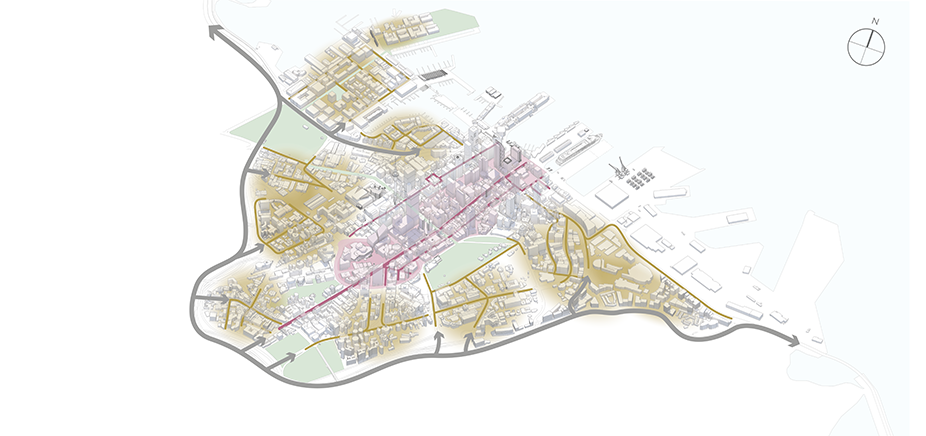
- Eastern Busway – Outcomes of Public Consultation on Preferred Scheme – Will we see the scheme change back to staying on Ti Rakau Dr or will AT continue with the Burswood deviation?

- NZ Police – Assistant Commissioner Bruce O’Brien – I wonder if the police will be committing to greater enforcement?
- Road to Zero Programme & Next steps – AT are getting ready to launch another round of speed limit changes but approval for that was given at the last meeting.
- Access for Everyone – A4E as it’s otherwise known is a key part of the City Centre Masterplan and is about making the city centre more people friendly by changing how traffic around the city works. AT have been working on a business case for how to implement this so presumably this is asking the board to approve it.
- Auckland Parking Strategy – Approval for Consultation – Auckland Transport have been reviewing their 2015 parking strategy – that they never bothered to try implement. There has already been some discussion about it, such as at Council.
- Auckland Transport Statement of Intent (2022 – 2025) – The SOI outlines ATs plans for the subsequent three years, though is updated annually. I wonder if there’ll be anything that stands out in this years version?
Business Report
Here are the items in the open business report that caught my attention.
Ash And Rata Streets
Last year Auckland Transport consulted on safety improvements to Ash and Rata, but as we’ve highlighted before, not for bikes. It seems they’ve not settled on the changes they’ll make.
AT is proposing to proceed with the following safety changes to Ash and Rata Streets, subject to funding:
- New signalised crossing on Ash Street next to Highbury Street and a raised table in the eastbound lanes.
- Raised safety tables at the intersection of Ash Street and Rosebank Road.
- Signalising the intersection of Ash Street and Wairau Avenue and adding a raised table.
- Raised safety tables at intersection of Rata Street and Great North Road.
- Electronic driver feedback signs along Ash Street and Rata Street.
- Road marking changes on the Whau River overbridge.
- Upgraded street lighting at those locations where changes are made.
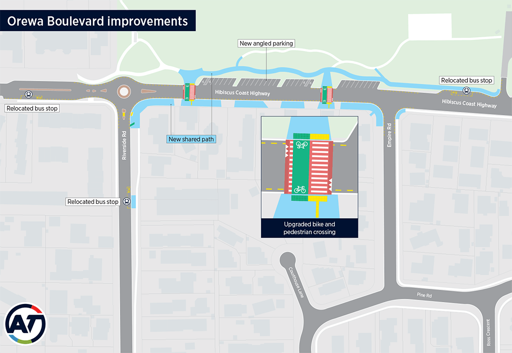
Orewa Boulevard Safety Improvements
AT say this project will begin in April/May. It’s a project that has a good name and has some good elements such as extending the the shared path further east and adding some raised pedestrian and bike crossings. However, it also increases (free) carparking in Orewa at a time AT should be looking to manage or even reduce it – inline with their existing parking strategy.
Special Vehicle Lane Programme
In a section on enforcing bus lanes, AT note
Queen Street is currently experiencing high volumes of bus lane non-compliance, and a review of the restrictions, current signage and road markings is planned.
Do the teams working on this realise changes to Queen St are currently under construction and will result in the removal of general traffic from the street?
They also say there are a number of new enforcement cameras either recently installed or on the way.
Procurement
AT always include in their report tenders and contracts issued that have a value of more than $2 million.
In the tenders section they include two. Hopefully this leads to better bus experiences.
- Bus Infrastructure Improvements Programme – Physical Works – Three year contract (2022 to 2025) – The programme will implement localised bus stop infrastructure improvements, geared to improving bus operations, pedestrian safety and customer amenity at bus stops and stations
- Bus Priority Programme – Physical Works – Three year contract (2022 to 2025) – The programme will implement localised bus route infrastructure improvements, geared to improving efficiency, reliability, and punctuality of bus services.
On the section of the contracts issued section is this one
- Northwest Bus Improvements – Westgate Station Detailed Design – This contract is for consultant resources to deliver detailed designs for the improvement of Westgate Bus Station. The project includes detailed designs of bus shoulder lane extensions, on-street bus stops and hybrid offline and on-street bus station in the Northwest Auckland area.
Construction isn’t due to start on the Westgate station till next year – meanwhile there is still no progress on the Te Atatu and Lincoln Rd sites.
Auckland Rapid Transit Plan
Auckland Transport have been developing a rapid transit plan but that has been thrown into disarray by the light rail announcement. AT now have to work out what impact the light rail decision has had.
With the Government’s announcement that the City Centre to Māngere corridor will be tunnelled light rail, work has commenced to determine how this corridor integrates into the wider network. A range of scenarios are being developed for testing, and from these results a preferred network will be identified and developed in more detail. This work is expected to be completed in April 2022
Pop up cycleway protection
AT have started work on the first route to get pop-up cycleway protection – eventually around 60km of painted cycleways around the region will get this. It also happens to be on the route I used to use regularly but haven’t lately due to working from home as a result of COVID. This is probably one of the easier ones for them to do as the painted lanes were installed with a painted buffer between the cycle lane and the general traffic lane.
Implementation of the minor cycling and active modes programme – pop-up cycleways providing segregation of existing on-road cycle lanes began in February. The first route is along Upper Harbour Drive, providing segregation on this popular route connecting the North Shore to the North Western cycleway. A further rolling programme will be delivered across the region.
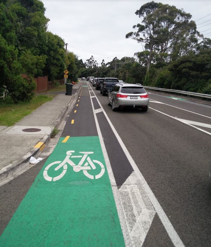
The Upper Harbour Dr cycle lanes before the protection is installed
I’m interested to see the quality of the separation they’re rolling out.
Monthly Indicators
Some of the comments in the monthly indicators really highlight how much worse deaths and serious injuries have been – meaning AT need to put a lot more effort in to improving safety. Of note there’s a 3 month lag in reporting so this is just up to September. Emphasis add is mine.
- For the 12 months to the end of September 2021, local roads DSI increased by 21.4%, to 545. This is 7.6% above the trajectory to meet the end of year target. Local road deaths have increased by 120.8% (from 24 last year to 53 this year). Local road serious injuries increased by 15.8% in the past year (from 425 to 492).
- For the 12 months to the end of September 2021, the DSI on all Auckland roads (including local roads and highways) increased by 19.0%, to 620. This is 7.0% above the trajectory to meet the end of year target. Furthermore, all road deaths have increased by 121.0% (from 28 last year to 62 this year). All Auckland road serious injuries increased by 13.0% in the past year (from 492 to 558).
- For the 12 months to the end of September 2021, DSI of vulnerable road users increased by 4.2%, to 270. This is 4.9% above the trajectory of this year’s target. Deaths of vulnerable road users have increased by 10.5% (from 19 last year to 21 this year). Serious injuries to vulnerable road users increased by 3.8% in the past year (from 240 to 249).
- All DSI indicators are not on track to meet the target. The high increases in DSI across local roads, all roads and for vulnerable users is likely due to lower police enforcement, alcohol and drug impairment, inappropriate speed, and lack of restraint use
Audio on Buses
An interesting paper titled Building a World Class Audio Experience on Buses looks at AT’s programme to add bilingual audio messages to buses to help those who are blind or have low vision as well as support te reo Māori. But as is often the case with these things, making it easier for these customers will make buses better for many other customers too.
Audio on buses will provide customers with simple and easy navigational support during their on-bus journey, including upcoming bus stop information and helpful guidance at transfer locations. With over 20% of customer trips including a transfer, audio announcements improve the transfer experience.
If you recall, last year AT renamed bus stops all over the region to make them easier to understand and it turns out that was the first milestone in this wider programme.
One of the things that stood out to me in the paper is that the equipment will also have benefits for HOP top ups.
In January 2022, the second major milestone was achieved with the hardware installed onto the first trial bus on 27 January. This provides three key benefits: faster AT HOP top-ups (from up to 72 hours down to one hour) which has been a pain point for our customers, bilingual audio announcements to help customers navigate easily with confidence and a new Global Positioning System (GPS).
They say their research found:
The main pain points included lack of accessibility and wayfinding assistance for blind and low vision customers, customers not knowing which stop to get off at (approximately 5,000 queries to bus drivers each day), 180,000 customers avoiding trips with transfers in them due to complexity and lack of wayfinding support and safety issues at night resulting in customers not being able to see their stops
The paper includes this example of some of the messaging users will hear.

This seems like a good improvement and hopefully AT have many more in the works to make PT easier to use.
If you’ve looked at the board papers Is there anything else that stands out?

 Processing...
WTF are they doing wasting resources putting in painted cyclelanes, what a joke
Would you rather nothing? Because that’s the actual alternative that AT will provide. See the critical link of Ash Rata for an example.
Anyway it’s sounds like Pop up bike lanes you mean. Captain Scott Road in Glen Eden has one in place from last year, parking getting converted into a bike lane with plastic bollards. Not perfect sure, but it creates a link to shared path and creates a hint of bike ablity.
Seriously the complaining about bike gutters and bike paths not being the highest possible standard, prevents space from being reallocated. Bike gutters as temporary options are a great stepping stone.
Ok I mis-read that, I thought they were adding more painted lanes, rather than adding basic separation on existing painted lanes
They haven’t said what they will be yet.
But still, bike gutters have a place. It’s probably not on arterial roads.
The usual alternative is constantly going parked cars, which is objectively more dangerous than having actual bike lanes even if it is only painted ones.
Just to be clear, they are putting physical protection on existing painted cycle lanes
The term “pop-up” is semi confusing here.
Why does the board even need to talk about this again? I thought they had sorted out all this out, funding allocated and paths chosen.
This is a good step, providing separation, in rolling out cycle lanes quickly.
The Burswood deviation is bad, but also the wiggly path through the park. While it might be fine for a Sunday joyride with the kiddies, it is hopeless for cycle commuting.
The need for work on a regional transport plan is telling. Clearly this has not been considered with the governments LRT design. No wonder it looks like a collection of ideas all trying to be solved with a single route. You’d hope the government would know more about planning but I guess they’re just doing what ministers are insisting on, and beggar the cost.
Slow progress on NW bus is disappointing.
The wiggly path at Orewa (if that’s the one you meant?) is designed to stay away from established trees/roots. https://goo.gl/maps/aW6irWBvrMKMupS19
I thought it was designed to go around that angled parking.
If you don’t want to use the safe path, no one is forcing you to. Stay on the road. It won’t be only commuter cyclists using it. It will be locals going to the bus stations. Or just kids on bikes getting around.
Stay on the road and … share with fast-moving traffic? Heavy vehicles? put myself at risk of getting run over and dying? Jesus, did you not read the earlier bit about the Road Safety performance and Deaths and Serious Injury stats for vulnerable road users?
Vision Zero and New Zealand’s Safe System explain how to design a transport network that would reduce DSI, hint it isn’t based on the principle she’ll be right.
And before you say well go around then, one of the core principles of cycle network design is Directness, that means like being direct. If people want to get somewhere they should be able to get there in a direct way, it’s doubly important for people walking/cycling and scooting as a deviation for these modes adds significant proportional delays and inconvenience.
AT said that they can’t build bike infrastructure on Ash Rata because, the standard safety intervention tool kit (released after the consultations) does not allow for the funding of bike paths. It doesn’t say this. Also how can NZTA justify spending millions on safety project that are not safe?
The safety tool kit does also allow you to narrow lanes and create side friction with separators to achieve reduced speeds. Maybe do this and then: hey look there is a 1.8m gap of redundant carriageway protected from cars, trucks and buses – let’s just leave it there and see if anyone can think to use it for anything …
“Auckland Transport have been reviewing their 2015 parking strategy – that they never bothered to try implement.”
Beautifully put Matt. It simply didn’t work because it was never implemented. And a phenomenal amount of money was spent not implementing it. Heading up Parking and Enforcement could be the perfect next career step for Lantern?
Lantern? The Green Lantern?
the nick name of the Police Commissioner
The angled parking in Orewa seems inherently very unsafe. With a large number of vulnerable road users who may or may not use the safer crossings to the beach, why would you introduce reversing vehicles to the mix? Not to mention that it is simply a travesty to use boulevard/beachfront space for car parking, gross.
Good to see all those speed changes on open roads from 100 to 80km/h have made a huge improvement to safety…. Oh wait *checks notes* they didn’t and have had the opposite effect! “ local roads DSI increased by 21.4%, to 545”
Now that’s not to say that some speed limit changes were needed. But we have them on country roads that are of better standard than many others both adjacent and around the country that are now 80km/h (and at great expense too).
My theory on the speed limit changes having apparently the opposite effect is that despite the changes, the average speed has increased dramatically.
Throughout all the lockdown, and even now traffic, is much freer flowing, rather than self regulating speeds from other cars. You used to not even be able to do the limit most of the day.
We need to have more breakdowns of the stats though. Were the increases in DSI primarily from streets where limits were decreased? or from places where the limits were not? Would the stats this year be even worse without the recent changes?
The other idea I have is sunday drivers used to always be the worst, now that less people commute and don’t do regular drives, way more people are essentially sunday drivers now. Not knowing where they’re going, not practicing as regularly at operating their vehicle.
They places they have reduced the limit is pretty small so far and yes I think it’s more to do with something about coming out of lockdown.
They haven’t had “the opposite effect!”.
https://at.govt.nz/about-us/news-events/evidence-shows-safe-speeds-are-saving-lives/
On roads where speeds have been changed there is a huge improvement on safety. Speed management works extremely well but, like most system change, it doesn’t work exclusively in isolation.
It’s just one important tool in the road safety toolbox.
Thanks, Ngaire.
“Good to see all those speed changes on open roads from 100 to 80km/h have made a huge improvement to safety…. “
Yes it sure is. Driving at that speed reduces energy by about two fifths. Amazingly effective eh. And it makes crashes less likely to happen.
Can’t wait for more.
Cool Jak… so you’re never going to use a vehicle ever again? Anything over 0km/h is risky. No trains or planes for you either. Even a horse and cart is more dangerous than walking. Back to the stone age… or even pre-industrial age where people lost their lives all the time from things that technology has thankfully reduced or removed for us.
https://imgur.com/a/IGkLIB2
Your kind of extreme / slippery slope argument is really silly. There is obviously a point of diminishing returns which we (by and large) will not cross.
Bringing down head on collisions to 70km/hr, generally means a limit of 80 (maybe 90) as people tend to have a few seconds to brake. This is a huge savings in death. It was a mistake to ever increase our limits to 100 on non divided roads, a political, populist, vote collecting move, that has overall harmed the country.
Here’s an interesting talk: Waka Kotahi Chief Executive Nicole Rosie speaks with Dave Cliff, former NZ Police Deputy Commissioner and now Chief Executive of the Global Road Safety Partnership in Geneva, about the evidence behind road safety.
https://youtu.be/QbihvZUmbSU
This new Chief Executive seems to be on to it, she also has a recent talk with the someone from Ireland about their light rail system they implemented, video is now flagged as private.
Really interested to see the comment about “Upper Harbour Dr cycle lanes”
I have asked AT before (with response pasted below), but this cycleway from Hobsonville/Upper Harbour drive to the North Shore has one horribly unsafe connection point with the Albany highway. I am really passionate about getting this fixed and have posted comments on here before about it
Anybody who has cycled the area (walking/running would be worse), will be aware of the intersection I am talking about, which dumps cyclists between lanes of fast moving traffic heading uphill with no easy escape.
I can’t imagine a worse connection from a cyclists point of view, and it destroys the network connectivity. How traffic professionals could look at this intersection and think it was good enough is beyond me; they even added a new hit sticks a while back as if to acknowledge that they can’t fix it, yet looks solvable to me as a non-traffic expert
There is some excellent new (and some older) active mode pathways around this area like under Constellation drive from Rook place, I assume put in as part of spending hundreds of millions on the northern corridor improvements, but until they spend just a little bit of time and money on this, it seems that these gaps derail the other improvements.
Images:
Coming up from Albany, the space on the left of the white line just ends, making cyclists climbing up the hill move into the path of fast moving traffic, with not enough width in the lane for people to give 1m of space. With the curve and concrete barrier of the slip road, driver end up cutting left. But there is room for a narrow path to be put in there to the left.
Route 26
Coming from Upper Harbour Drive, you end up cycling up hill, to the right of the hit sticks, with fast moving traffic to the left. If you have other traffic coming from Upper Harbour, you are squeezed with no margin for error between the lanes until there is a gap and you can cycle across the lane and get to the left
From Upper Harbour
Response from AT (from early 2021)
>”Thanks for contacting us regarding pedestrian and cyclist safety on Albany Highway
>I’m sorry to hear of your experience when riding through this intersection.
>I can understand how the current layout makes it difficult for cyclists and >pedestrians to navigate through this intersection.
>We’re investigating this intersection
>We’re currently investigating this intersection and also the lack of pedestrian >amenities from Korari Way to Unsworth Drive.
>While we don’t have any plans at present, we’ve taken the concerns you’ve raised >on board and will forward the suggestion to consultants that have been engaged >to come up with a scheme design for the project.
>We don’t have any timeline for works but we anticipate we’ll have some concepts >by the end of the year.
>We’ll now be closing your case
Thanks Grant. Have you talked to Bike Auckland? It might be worth it.
That is a standard reply from AT. I have received similar many times when asking for or suggesting changes to cycling routes. If the solution involves any impact on cars ( real or perceived) the answer is always no. If the location is anywhere near a motorway interchange and thus involves NZTA don’t bother wasting your time. The answer will always be no.
Re comment about more parking at Orewa beach. It is a very large beach and heavily utilised by a wide cross-section of people. People take more than a towel when they go. They use cars for very practical reasons: to transport people and equipment such as SUPs and surfboards, kayaks, kitesurfing gear, BBQs, food, trolleys, tents, music equipment etc. You can’t take that stuff on a bus and there is nowhere near enough affordable housing within walking distance, let alone enough enough housing full stop. Apartments don’t always have adequate storage. And the main car park is about to take a large hit with the new surf lifesaving HQ going on it. I figure a few extra car parks would be welcomed by the community. I accept induced demand issues – but the beach and reserve is a significant community resource and public transport and amount of development in the area does not serve it. By all means get better bus services down there, but some more parking is ok. It’s still ok to provide parking when it’s necessary right? Not sure angle parking and reversing into the highway is the greatest design though. A dedicated parking area would enable safer loading and unloading of vehicles and equipment than the current design. Paid parking might help managed overuse – but it does create an equity issue: the beach becomes too expensive for some families to visit.
This is where sticking to policy would help – it would demonstrate the value of the policy.
If you accept induced demand issues, you need to accept the impacts of this additional traffic. It slows public transport down – and randomly so, making it less reliable. It adds conflicts between vehicles and people on bike and foot, reducing both actual and perceived safety. It increases carbon emissions.
Parking therefore directly impacts public transport and active transport options, and it causes climate change. These three outcomes have more equity impacts than charging for parking does.
So no, Orewa should be receiving improved public and active transport infrastructure and services, its parking should be priced, and it should be having its parking supply reduced. Just like everywhere else.
Will reducing parking reduce VKT or will in just create more trips up to Wenderholm and increase VKT? Maybe it will just mean Orewa beach is reserved for those with the money to live walking distance away.
The outcomes of reducing parking supply are not in question. Consistent application of the policies are how to overcome any problems arising from relative attractiveness of different locations.
In many overseas cities people get to the beach using public transport. I am sure that if parking was charged at our beaches, and why shouldn’t it be because there is a cost to provide it, then many fewer people would drive.
Yes we have good frequent buses currently to at least Mission Bay, St Hellers etc & Pt Chev.
Counterpoint: Mission Bay and Pt Chev are already massively oversubscribed and realistically you’re not going to fit any more people in there on sunny days without the experience being hugely diminished to the point it’s not worth going.
Perhaps this would be viable if we had a city with half the population we do, but there is huge demand for most of our beaches on sunny days and suggesting more and more people just got to the central ones that are already overwhelmed is not really a credible substitute for going to one that has fewer people.
Non weekends/holiday’s these beaches are normally quite empty. These is buses to other places, would be good to have a service to the west coast ones.
Having been past Orewa on a busy summer weekend, what they need is bollards to stop parking all over the grass reserves.
Regarding taking your kit to the beach, sure: but why not loading zones and then parking away from the beach? The mindset of being able to park directly outside the thing you’re driving to definitely needs to change. See also, roadside parking on arterials.
The thing with Orewa is, you either drive there, or you go somewhere else. You’re talking here about covering 30 kilometre on public transport. It takes an hour to go from Akoranga station to the bus stop in Orewa. That is just too slow, and it will be too slow until we get intercity trains. I don’t see how those would appear here within our lifetimes. Or maybe intercity buses would work in the meantime?
Maybe the policy would be that we aren’t supposed to go all the way to Orewa in the first place. Fair enough, but I don’t expect businesses in Orewa to like that.
If the car parking is full then the policy should be that either:
-People choose one of the 19 beaches between Orewa and Akoranga (not even counting those on the Whangapararoa Peninsula
-People park on the streets back from the beach and walk; or
-People take public transport
In any of these cases, the parking at the beach should be pay and display at weekends.
Poor flightless, sightless kiwis. So utterly unable to imaging doing anything without their cars – regardless of how many problems those cars cause. It would be laughable if it weren’t so pathetic.
Have tried to, but you can see from articles dated back to 2019 and earlier, they see the same issues, but ultimately have to do the same and ask AT or ACC. Which is not working to get change made.
https://www.bikeauckland.org.nz/albany-so-much-potential-so-many-gaps/
I hate to say it, but probably will take somebody dying or serious injury on this bit of road for a manager inside of an organization like AT to be prompted to actually do something.
In the response I got, they say ‘forward the suggestion to consultants’, but no clue who the consultants are, and who/how they are consulting with. For my IT designs, I generally try and validate design proposals early and often with stakeholders before too much work is done
Would it be worthwhile raising with local body or councillors like Richard Hill?
I find the near-constant audio announcements on the Inner Link buses really intrusive and annoying. I wish there was another approach to help those who need this kind of extra assistance.
The trains are terrible as well. Especially at the start of the journey. It’s legitimately a few minutes of audio assault. Just when you think it’s done they launch into another paragraph.
All it needs is a “Next stop xyz” (repeat in Te Reo). with sparingly used extra info.
The example one shown in the graphic above “please remain seated until the bus stops” is exactly the kind of audio pollution that is so seemingly attractive to big organisations, but is so damn annoying for regular users.
Real effort is needed by AT to thin down even their examples shown above. It shouldn’t be Change here for eastern line trains to Britomart”. It should be “Change here for Eastern Line”. I don’t speak te Reo, but the counterpart for that looks like a paragraph, is that really whats required to convey that information? Google translate doesn’t seem to think so.
Its annoying enough for me, I cant imagine what it would be like if you had more severe sensory sensitivity. Would be a legitimate reason to get out of PT and take the car.
Or wear headphones (noise cancelling, if you have the budget).
Definitely agree that they should minimise the length of the announcements. Also, ensure that the speakers are of suitable audio quality! Cheaping out on that usually means cranking up the volume to compensate, and you end up with blaring unintelligible noise.
I notice in some trains the audio seems to be off, it must be driving some of the train managers crazy as well.
“I find the near-constant audio announcements on the Inner Link buses really intrusive and annoying. I wish there was another approach to help those who need this kind of extra assistance.’
There are options, but AT chose not to introduce them. The TeReo announcements are PC gone mad.
Well done to the new intern director, Izzy Horrocks, for asking at the meeting how cycling had performed during covid times.
Less credit to the AT staffer who in her response could only comment on inner city monitoring.
Even less credit to the Deputy Chair who started to talk about public transport. While he might consider it a form of public transport it certainly isn’t.
I came away from the public section of that meeting unconvinced that the stewardship of AT is in good hands. Good attention paid to road safety, but the attention to zero emissions was light.
Another interesting snippet from the meeting was the very significant impact that lower speeds have had on deaths, injuries and accidents. While the sample size might be small it was very encouraging.
The same AT staffer who I referred to above was questioned about PT patronage and what could be done to boost flagging ridership. It was very heartening that she expressed that trips other than the commute should be focused on. Hooray, a network that can be used all day/every day to provide the transport needs of many Aucklanders.
Well done to the Chair for asking about outlying residential developments and whether vkt had been modelled.
The Burswood deviation is a crucial decision for the local community. AT have been very deceptive in their engagement with the community. After excessive delays documents show Ti Rakau Drive will likely be the test road for congestion charging in Auckland. Plans also show Panuku development will take extra properties to intensify the area…all hidden from residents. This is a community of houses on mostly 200 square metre sections! It is one of the only suburbs in Auckland that do not have a single quarter acre section in it. Resident also do not have high flying corporate jobs in town. They have completely missed the mark.
“This is a community of houses on mostly 200 square metre sections!”
Blatant lies like this won’t win you any fans on this blog. Pretty much all of the sites are 550-650 m2 – https://homes.co.nz/address/manukau/east-tamaki/29-dulwich-pl/QnN9z
Good point. I was referring what I read in an article and didnt check.
https://www.nzherald.co.nz/the-country/news/the-nz-suburbs-where-the-quarter-acre-dream-has-all-but-died/
– for example, Burswood, in Manukau City, has none and Golflands next door has only one.
https://www.nzherald.co.nz/the-country/news/the-nz-suburbs-where-the-quarter-acre-dream-has-all-but-died/WJ3ZHDTI2TQLD75ZDIM5MYT6J4/?c_id=16&objectid=12348742
Thanks for coming back to clarify, FYI, A quarter acre is ~1,000m2. If the busway is built there, the whole suburb has to be rezoned to allow 6 storey apartments, so there is plenty of capacity for intensification. It’s just a dumb idea because it’s a huge diversion and the stuff on Ti Rakau Drive is much better for intensification.
“Resident also do not have high flying corporate jobs in town”
It might interest you to learn, then, that the Eastern Busway does not go all the way to the central city.
In fact, combined with the A2B mass transit project, and the interchanges with rail at Panmure, Manukau, & eventually Ellerslie too, it should open up a wide variety of non-CBD travel options for south and east Auckland.
Then why is is being marketed as a transport link to the city? You must not be a big user of public transport in Auckland. You’ll be transferring between multiple buses and trains. AT need to first focus on having services which are on time and go to where people need to go. This should be prioritised by need not disneyland transit.
Hahaha, mate. I am a disabled Aucklander, I can’t drive, and so I am very familiar with Aucklands buses trains, and transfers. And let me tell you from experience – when designed and operated well (i.e 10-15 min frequencies or better) transfers are a breeze. Some people should not be so dogmatically opposed to transfers.
Mass transit isn’t “Disneyland transit”. The Eastern Busway is meant to make Ellerslie-Botany buses more reliable and higher-capacity. The Airport-Botany mass transit will connect Botany to Manukau to the Airport – and most Airport employees live in those East Auckland suburbs along that corridor.
Yes, optimising existing bus routes is needed, but that does NOT negate the need for mass transit. Busways & rail provides capacity that buses on bus lanes can’t feasibly match – capacity for increasing demand and intensified development.
https://www.greaterauckland.org.nz/2021/10/28/the-shift-to-secrecy-is-damaging-transport-outcomes/
Interesting read.
re: the missing the mark with EB.
The 70, running from Botany to Britomart is one of the busiest bus routes in the country, second only to northern busway routes. The eastern busway makes the most important part of that route congestion free. The Botany town center is also a key destination, along with every station on the eastern line. Particularly silvia park. There is already massive demand for that route. I also know a number of students that go in to the city universities from out east.
“AT need to first focus on having services which are on time and go to where people need to go. ”
Perhaps AT could build a busway so that buses can run on time?
If they are in the most direct route. If you haven’t looked at the plans, these buses are not exactly direct and delays the inevitable that Ti rakau drive will need to be addressed. People shouldn’t be accepting a sloppy busway.
Yep, the diversion isn’t very smart, so why lie about it to make it look bad?
Eventually, that eastern busway will allow quick access to so many destinations with no more than one transfer – airport, CBD, Sylvia Park, Newmarket, Parnell, Mt Smart, Manukau. If the cross town line eventuates it will also get you out to the Western Line -New Lynn Mall, Eden Park, Kingsland amd Morningside restaurants etc – with a single, seamless change.
It really will be transformational for that part of Auckland.