On Friday, the council published the newly refreshed City Centre Masterplan that was consulted on last year. That the council had already done so much work on it has also clearly had an impact on what they’ve been able to roll out on Queen St over the last week in response to COVID-19.
Auckland’s City Centre Masterplan, the visionary document to guide the city centre’s development for the next 20 years, is now accessible to all via a new digital platform.
The masterplan, which was endorsed by Auckland Council’s Planning Committee in March, sets out a vision for a greener, safer, and better-connected city centre that celebrates our unique Māori identity.
Councillor Chris Darby, Planning Committee Chair acknowledged the changes COVID-19 is having on our city centre and the way we view street space.
“The adoption and digitisation of the City Centre Masterplan comes at a time when we are more focused on how our streets can function to allow people to physically distance. Being able to move around the city safely is a focus for those that live and work in the city centre.
“During Alert Level 4 Aucklanders have enjoyed having more space to walk and cycle and it’s given us a glimpse of what it’s like to have streets focused on the wellbeing and safety of people.”
Of the 542 Aucklanders who submitted feedback during public consultation, 76 per cent supported the overall direction of the masterplan. The most frequently mentioned theme was the masterplan’s direction towards greater pedestrian friendliness in the city centre.
Tim Fitzpatrick, City Centre Design Manager at Auckland Council said he is proud of the work they have done with the City Centre Masterplan and said the plan has proved very useful in formulating Auckland Council and Auckland Transport’s COVID-19 response.
“The extensive work on the City Centre Masterplan and its access planning has been invaluable in allowing us to roll out an emergency response that ensures physical distancing can be maintained on Queen St in COVID-19 Alert Level 3.
“Although this work is temporary it will give us an opportunity to move seamlessly from streets designed for physical distancing during COVID-19, to streets that reflect our City Centre Masterplan and the vision to reallocate more street space for people.”
Sometimes there’s nothing more permanent than a temporary fix, afterall, just look at the ‘temporary’ slug still sitting on Queens Wharf nearly nine years after the Rugby World Cup.
As we’ve discussed before, the to biggest changes to the plan are the inclusion of
- Access for Everyone – which aims to make the city centre more people friendly by changing how streets in the city work. It will it possible to still drive to the city but once fully implemented you won’t be able to drive through it. This then allows the reallocation of substantial streetspace away from cars and towards open space.
- The Grafton Gully Boulevard – that would see Stanley St and The Strand changed from a pseudo motorway into a tree lined boulevard that supports significant development.
The most interesting part of the newly published plan are the gorgeous digital maps and graphic what’s planned. There are eight interactive maps that show the key changes proposed by the plan – one for each of the transformational moves in the plan.
CCMP envisages ongoing redevelopment and regeneration of Wynyard Quarter, with mixed use development and green links leading to a flagship new green space on Wynyard Point.

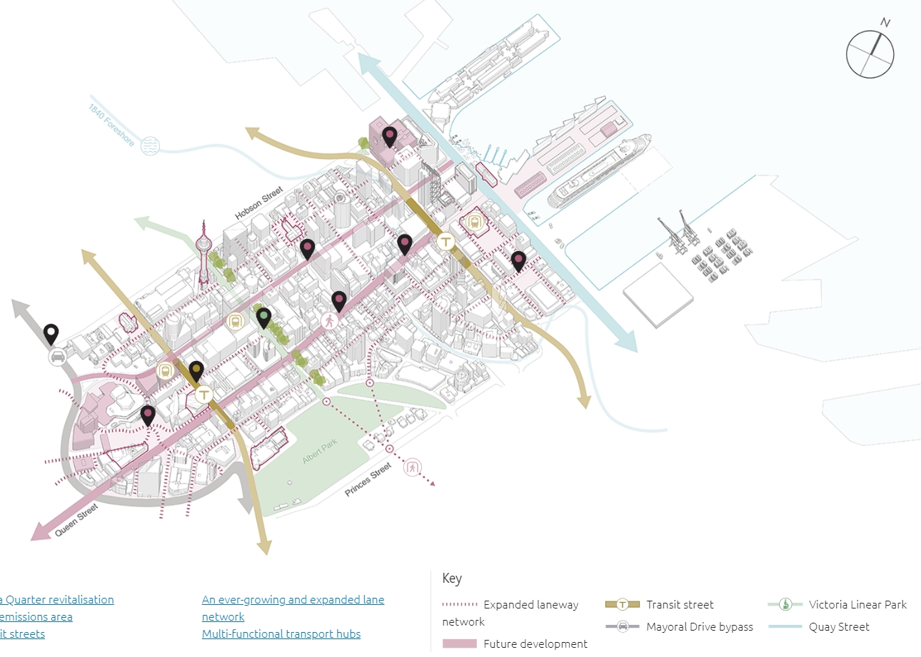
CCMP envisages staged redevelopment of cruise and ferry infrastructure to unlock new waterfront public spaces, with a transit street on Customs Street enabling enhanced access and integration with Waihorotiu / Queen Street Valley.

CCMP envisions a new multi-modal boulevard and future urban neighbourhoods for Grafton Gully and Te Toangaroa / Quay Park seamlessly stitching the eastern edge of the city centre with the heart of the city and eastern city fringe neighbourhoods.
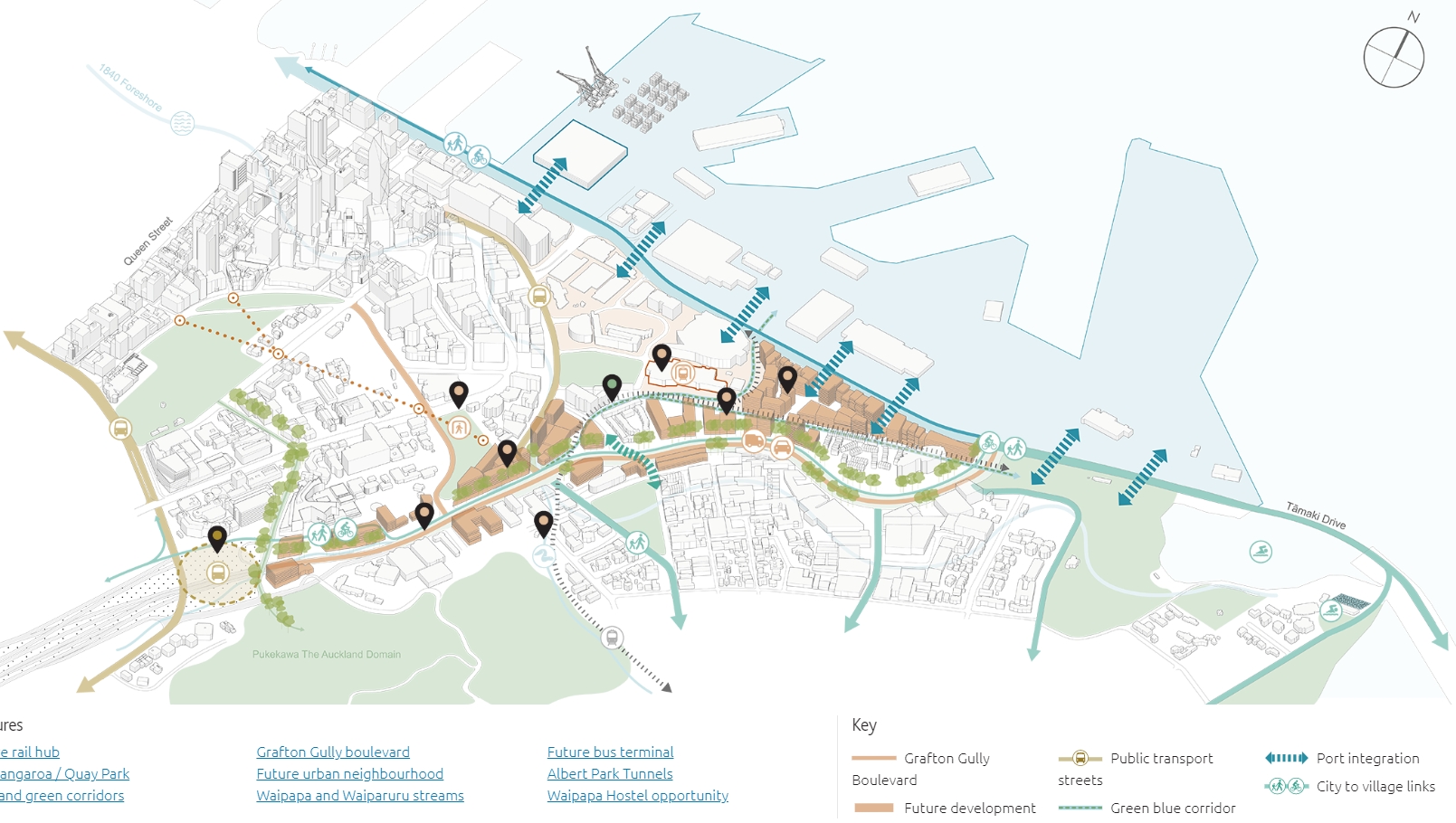
As mentioned above, the addition of the Grafton Gully multi-way boulevard (below) is one of the key changes to the CCMP. The plan also includes in it the reopening of the Albert Park tunnels

CCMP seeks to improve the network of big streets and blocks to be more human-scaled and people-oriented. It will also overcome the severance and movement barriers that isolate Victoria Quarter from both the heart of the city and western city fringe neighbourhoods.

Waihorotiu / Queen Street Valley
CCMP seeks to bring new life into the heart of the city with a revitalised, pedestrian-priority Queen Street. The laneway network would be expanded as the centrepiece of a new zero emissions zone, which is free of through-traffic.
The council’s response to COVID-19 is seeing some of the changes to Queen St start to be implemented already and helps to highlight the value of having plans. We really need them for more areas too. As a result of that, within the next 1-1½ weeks the main Queen St changes, removing private vehicles from driving along it, will be in place.
CCMP seeks to enhance integration and access to city centre universities through rapid transit, and walking and cycling connections. It will create a more attractive, expanded city campus environment through significant street network changes enabled by Access for Everyone (A4E).
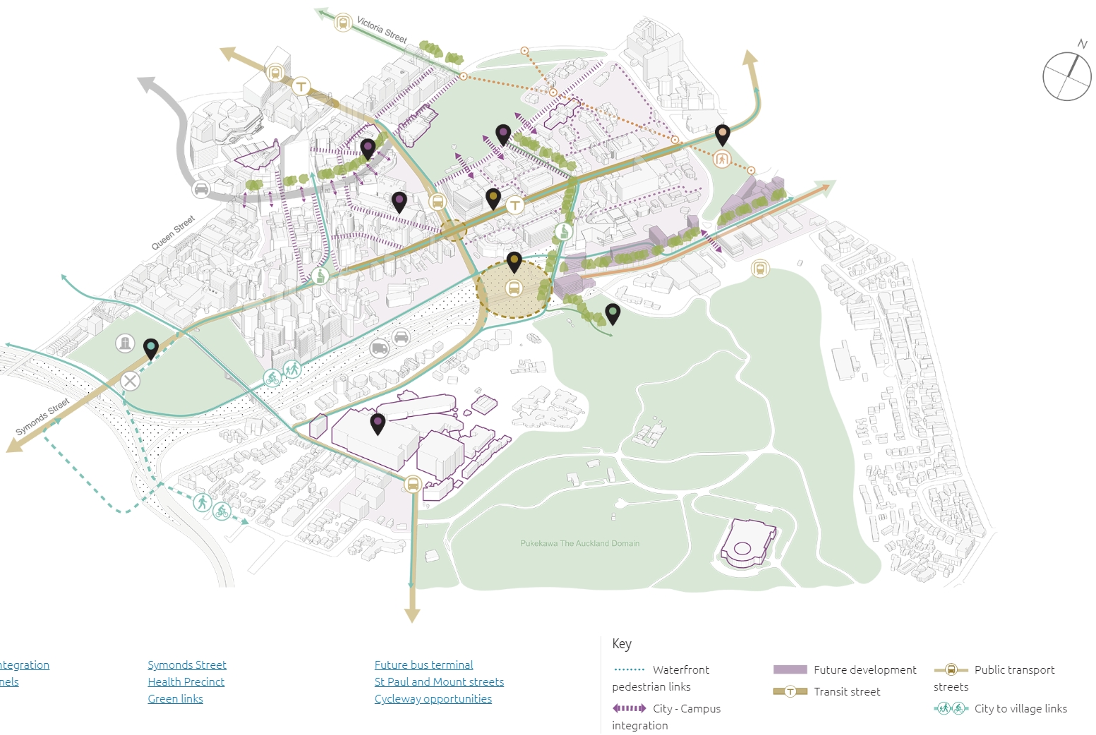
One of the key changes proposed in the Learning Quarter is to redesign Symonds St and the image below highlights what that could look like. The street would become a transit street with no general traffic through the heart of the Auckland Uni campus which frees up space for continuous protected bike lanes from Upper Symonds St to Britomart. It would also create more public space and have links to an interchange with buses on Wellesley St.

CCMP envisions a new hub of transit-oriented development, and pedestrian-priority streets and public spaces. These build on the massive place-shaping investment underway in rapid transit stops and stations.

One of the projects that can be seen here, and also in the previous Learning Quarter image is the proposal to close the Symonds St motorway on-ramp. This would help by stopping driving through the area to access it and also significantly improve safety for pedestrians and bikes. The CCMP also suggests linking it with Grafton Rd for improved connections and that could help take pressure off buses and bikes sharing Grafton Bridge.
CCMP envisages transit-oriented development to create two new urban neighbourhoods around Dominion Junction and the City Rail Link (CRL) Maungawhau / Mount Eden Station. This includes new and enhanced walking and cycling connections including a signature beltline greenway along Ian McKinnon Drive.

Combined, the City Rail Link site at Mt Eden and the proposed removal of the Dominion Rd flyover open up significant opportunities for urban redevelopment close to the city.
Overall the plan represents a fantastic vision for the city centre and is the result of a lot of hard work by the council and in particular the Auckland Design Office who have driven it. I just wish we could have it all implemented now, put perhaps if we can learn to love more quick and cheap temporary solutions, we could do large parts of it.

 Processing...
Great. I hope we don’t have to wait long for these improvements. It’s desperately needed. I’m really looking forward to the Symonds St changes. It’s such a dangerous street.
Shouldn’t they be closing that ramp now, making use of the lower volumes? If I was to get caught out by the change now, it’d be much better than when traffic’s returned fully. It’s just not such a big deal to change route. Then by the time volumes rise again, there’ll have been word of mouth letting more people know.
I suppose that holds for all the changes – Council could make it easiest for us by doing it now.
It would be cheaper to dig new tunnels under Albert Park than dig out the old ones, remove all the rotten timbers and replace them. Does anyone really think we need new tunnels under Albert Park? Then why the hell would anyone waste money on the old ones?
At best it will be like the ‘historic’ wishing well in Albert Park that marks the location of the original well used by the early garrison, which was actually built near the old well because the old well was collapsing. (The spoil from the new hole was used to fill in the actual historic well.)
I’d be surprised if it was cheaper to dig and reinforce a brand new tunnel, rather than just reinforce the existing one.
But regardless, the Albert Park tunnel proposal is awesome.
Miffy, there is no way it will be cheaper to dig new tunnels that to clear the muck out of the old ones and shotcrete fibre-reinforced lining to the interior, which is the proposal.
There’s no suggestion of restoring any ‘historic’ structures, they are dead and gone. All that is left is holes in the rock half filled with wet clay blocks and the odd scrap of timber.
Nick R you are a hell of a lot braver than me if you are prepeared to go into an unsupported Auckland clay structure and work. All the clay that was dumped in there has to be removed and the hole has to be held up while it is lined. It would be safer to just start again with a small TBM and probably work out cheaper as there would be fewer problems to deal with. then there is the issue of what in the hell would anyone want to go in there for. I can understand it if the Japanese were dropping bombs on us, but that seems unlikely.
Apparently when they ‘restored’ the well they found it and opened the top and saw wet clay basically falling in, figured ‘stuff this’ and dug a new hole beside it and dumped the spoil straight into the old well.
Yes the clay has to be removed, but the clay was brought in from New Lynn in the first place so that’s no big deal.
The tunnel will hold itself up because it’s primarily though ECBF sandstone and has been holding itself up for 80 years since it was dug. FYI the clay fill doesn’t go to the top of the tunnels, it’s actually doing nothing.
Oh and by the way the tunneling engineers report states the tunnels are in remarkably good structural condition, to the point where simple fibre shotcrete is a sufficient lining method.
This is awesome!
Who do we pressure to get the Transit Streets on K Road, Customs Street and Symonds Street in place right now?
Given all that has gone before over the last 2 years, either this assumes that the port has been shifted, or container trucks haul their way up Ngapipi Rd, about which residents will have something to say.
Either way, people will not enjoy a boulevard on The Strand and Grafton Rd, while container trucks are chugging past.
What’s the plan for Auckland’s freight needs ? And the time-frame ?
“Either way, people will not enjoy a boulevard on The Strand and Grafton Rd, while container trucks are chugging past.”
Why not? There are hundreds of pleasnat Boulevards with heavy vehicles in Europe.
This assumes that the port traffic will use the boulevard designed for it.
Are you saying that the boulevard doesn’t meet the port traffic’s needs? Why? Does the port traffic require an ugly and unsafe road?
Or are you saying that port traffic will spill onto roads unintended for its use? If so, there needs to be stronger clarification about where big trucks may travel, and enforcement.
So cos of port traffic a six lane road won’t replace a four lane one? Huh? What you smoking Kipper?
I don’t think quite you understand how the multi-way is going to work. Here’s the Octavia in San Francisco
https://www.sfgate.com/bayarea/place/article/SAN-FRANCISCO-An-urban-success-story-Octavia-2659608.php
Not following that logic, currently port trucks use the 2-4 lane road, but replace it with a 6-8 lane boulevard and suddenly they can’t?
https://www.aucklandccmp.co.nz/opportunities/albert-park-tunnels-realising-the-vision/
Is the graphic on this page wrong?
I thought the main tunnel was level with the paved area at the base of the stone columns, not several metres below?
An elevator, escalator or stairs up to the old arts building would certainly make for a good all weather access to Aotea (apart from crossing Elliot St, Queen St and High/Lorne St).
Not wrong, it’s and extra concept. Yes the old tunnel started at the paved area, but then dropped down quickly before flattening out. This is an add-on idea, basically avoiding walking up the last block of hill only to walk back down in the tunnel.
The Albert Park Tunnels concept has lifts and stair shaft at Princes St (in front of the Clocktower building) and again at the corner of Symonds St and waterloo Quadrant, plus the level entrances either ed.
How does the private sector make a profit from this? Do they draw a couple of sketches, encourage the public sector to do it then demand payment for their intellectual property? It worked elsewhere.
By creating 5,000 sqm of floor area in the middle of the city centre for retail, tourism and hospitality tenants with a massive foot traffic generator attached.
All looks good. So much that can be done.
Do you have it in PDF? Where do I go found all these information?