The Eastern Busway is one of the biggest and most important transport projects in Tamaki Makaurau right now. The first stage of the Eastern Busway between Panmure and Pakuranga is nearly complete and due to open next month.
Now Auckland Transport have launched consultation for their draft design for the remaining 5km stretch between Pakuranga and Botany, and there are some major changes to the compared to designs that have been presented in the past. The most notable difference here is at Burswood but there are also changes at Botany and to the bike network. Concerningly these changes all seem focused on finding ways to not upset existing traffic flow and priority. They also seem to be another product of the growing trend to secrecy where the public are presented with near finalised plans right at the last minute instead of agencies canvasing the issues of previous designs with the public before coming up with solutions.
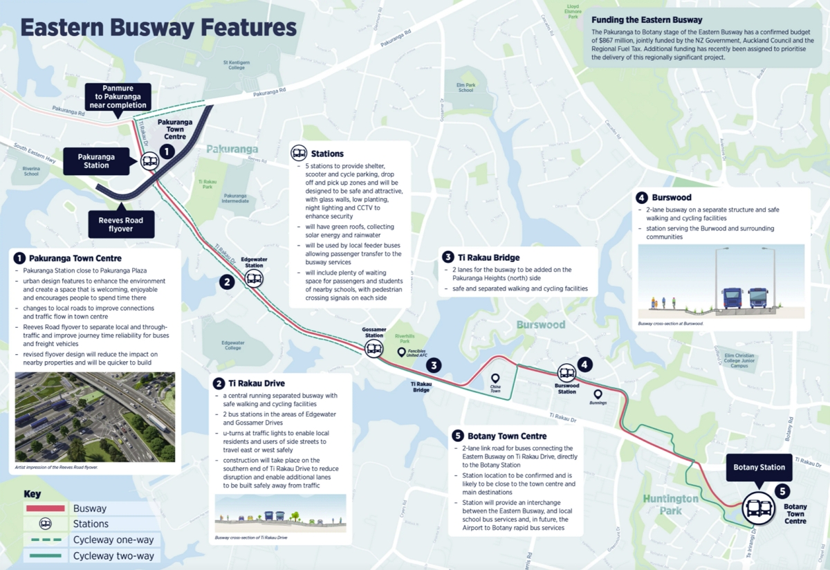
The Burswood Deviation
The northern section of the project between Pakuranga Rd and Gossamer Dr remains the same as we’ve seen before with a major station to be built at Pakuranga and then the busway down the centre of Ti Rakau Dr.
From Gossamer the new plan is to shift the busway back to the northern side of Ti Rakau and then for it to go around the back of the commercial area at Burswood to a station, taking out 30-40 houses, before sending it back to the northern side of Ti Rakau.

The primary reason AT give for this change in design is the cost, saying that sticking to Ti Rakau Dr would see the cost of the project exceed the $867 million budget. They also claim this option has benefits for safety, is 12-18 months faster to build so results in less disruption, is better for bus speeds and reliability and is better for general traffic.
The argument for improved bus speed and reliability is that buses would only have two low-traffic intersections to pass through. Those intersections would have lights added and buses would be given signal priority meaning the only time they would normally need to stop would be at the Burswood Station. By comparison there are currently five major traffic light controlled intersections on this stretch of Ti Rakau.
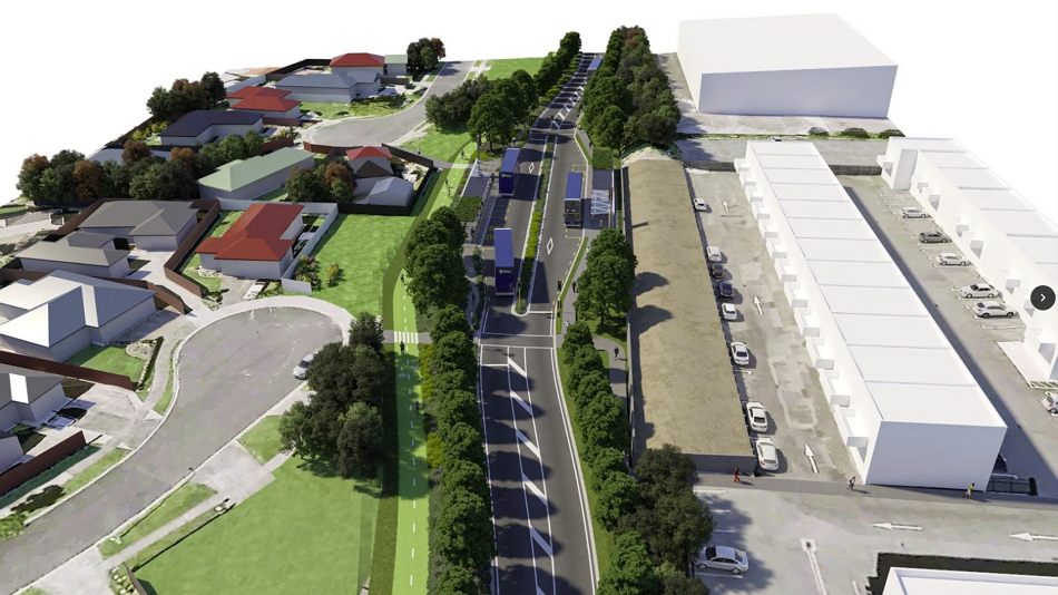
The proposed Burswood Station
I understand the argument and also note that while it looks significant, it does only add about 300m to the overall length of the busway. But I’m yet to be convinced this is the best outcome and here’s why.
They say this is not the case but the strong impression I get is that even though it’s not in any of the outcomes they say they’re seeking, someone in the middle of AT has decided the project needs to reduce the impact it has on general traffic. The project team then work backwards from there to come up their proposal and the justification for it.
For example, the main reason for the high cost is because the engineers say the busway can only be achieved by widening the entire corridor to accommodate not just the busway but also all the existing turning and other auxiliary lanes on this section. The lack of reliability is due to right turns being permitted at every intersection. In addition they said the widening would impact on the access to the commercial properties on the south side of the corridor.

Yet both council and government plans call for significant mode-shift away from private vehicles and for a reduction in amount of kilometres travelled in vehicles to help tackle both emissions and congestion. The traffic models being used to justify the need for those lanes and for diverting the busway will almost certainly not be taking that kind of change into account.
Instead, changing most of the intersections by removing right hand turns so they are left in/out only would reduce the need for property take an make buses more reliable. Drop some of those other additional lanes and that cost could reduce further.
The image below is what would fit within most of the existing corridor now.

It would be interesting to see the outcome of the consultation if an option like this was presented alongside the new preference for a diversion.
Urban Redevelopment Potential
Another factor that AT say counts against keeping the busway on Ti Rakau is that they say it has ‘reduced future land use opportunities’ compared with the diversion option. At the very least it seems like it would be much easier rezoning and redeveloping the large commercial blocks on the south side of Ti Rakau than it would be acquire a lot of the small residential properties in Burswood.
Burswood Connections?
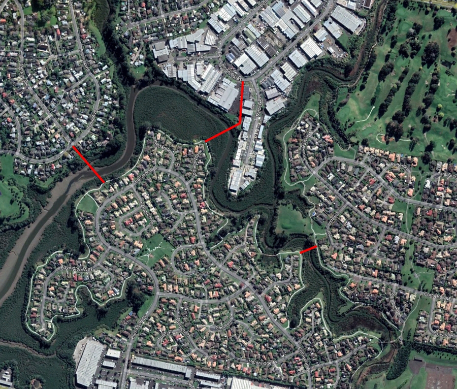
One thing that strikes me about looking at Burswood is that it is a peninsula that could easily be connected up to the nearby areas with some simple walking and cycling bridges. These could also enhance the catchment of the station and I wonder if the locals should be asking for some of them as mitigation for the proposed change in route. Some options could include:
- To the West to make it easier to get to Riverhills Schools
- To the North to link to the industrial area around Ben Lomond Cres – there’s a Watercare site with access down to the water which could be useful here
- To the Northeast which could put houses there within walking distance of the station.
The Botany Deviation
The busway is also being diverted east at Botany end too with the proposal for it to cross Ti Rakau Dr and then through Guys Reserve to a station which appears to be around Te Koha Rd. That station would also be the end point of the Airport to Botany busway that is being planned. This route would be a slightly faster journey than going through the massive Ti Rakau Dr / Ti Irirangi Dr intersection.
What surprises me is that AT have gone for the option that paves over part of a reserve.

There are no images yet as to what the Botany station might look like.
One less station
An additional change from previous plans is they have dropped the proposal for a station at around Huntington Dr.
The Bike Network
You’ll noticed from the maps above that at Burswood the proposed cycleway also diverts off Ti Rakau. AT say the reason for this is safety and avoiding having it cross multiple driveways on Ti Rakau, even though it will need to cross almost just as many driveways on Burswood Dr.
Looking at the map there are only a few properties that don’t also have access a side road like Burswood Dr or Torrens Rd. I wonder if AT couldn’t have just worked with those property owners to rationalise driveway access and keep the cycleway on a direct route.
A similar issue exists at the Botany end but Botany also raises another question, how do those from east/northeast of the area access the cycleway?
I appreciate this project can’t deliver everything but it feels like at least getting a cycleway as far as the Ti Rakau / Ti Irirangi Dr intersection should be in scope here.
Reeves Rd Flyover
As mentioned earlier, the plans at the northern end of this stage remain unchanged and that means the Reeves Rd Flyover is still on the cards. Like with the Burswood deviation, AT continue to claim this is all about making the buses more reliable and reducing congestion even though it’s really about making it easier for drivers which will encourage more people to drive and make congestion worse. Also, if this is what a major public transport project looks like …….
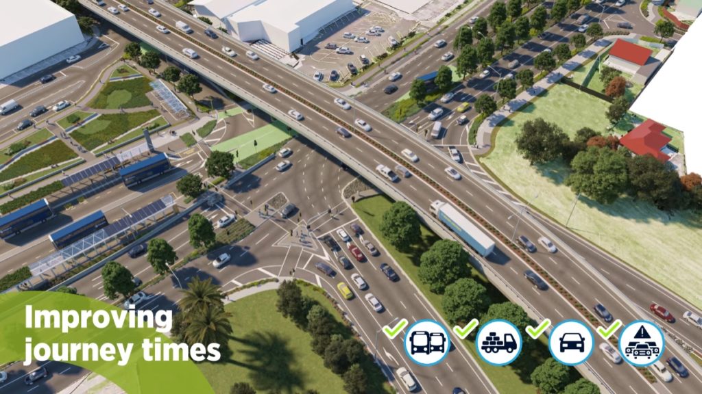
Why are AT adding in or retaining slip lanes. And for pedestrians there are up to five crossings they will have to make to get from one side of Ti Rakau Dr to the other, such as from the Southwestern side (right hand side on the image above) to the mall. That’s hardly a way to encourage more walkable and cyclable communities.
Consultation is open till 10 December and AT say they hope to have some enabling works underway late next year with the whole thing finished by 2026 – which is a delay with it previously being 2025.
https://youtu.be/5XXkiyA9UEM

 Processing...
I can’t understand why public reserve land (which is for the benefit of all Auckland) is sacrificed to avoid purchasing privately owned commercial or residential property. IMHO that should be a non-option.
Wouldn’t one of the benefits for putting cycle way/busway into Burswood mean it is better placed for residential area there? Same with the cycle way. Your suggestion about putting extra cycleway connections around Burswood make sense….. but neither deviation really detracts from the project. Sorry, I don’t see them as necessarily a bad change.
It looks like improved connectivity for Burswood residents, improve bus times, cost control, less disruption.
I wonder if putting the botany bus station where it is means easier connection to A2B project. (Or at least less disruption of botany carparks
Yea, the deviating to be more accessible to Burswood thing feels kinda overblown. People in Burswood would be in for a long walk to access this busway if it goes the other way. 300 hundred meters extra, to access more people and avoid 5 set of lights does not sound too terrible for AT.
With a busway like this you have to play the long game. This commercial area, plus the south edge of Ti Rakau Dr can be developed into a substantial town centre. Access from Burswood can be provided by building bike lanes.
Are you trying to design long cycle trips from east to west? From residence to hypothetical workplace at a distance?
Those trips are only one type of trip a cycling network needs to serve. To provide access for the whole array of journeys that people do, means providing access to all the industrial and retail properties, as well as to residential properties. If you deviate to Burswood and keep Ti Rakau Drive unsafe for cycling, how do people on bikes get to the Ti Rakau Drive properties, and to all the workplaces south of Ti Rakau Drive?
If they keep the protected cyclelanes on Ti Rakau Drive, people can still cycle along Burswood to access residences there, but the future connections to protected cycling on Harris Rd and the other “this decade” routes for protected cycling will be much easier.
If they not only kept the route straight but also used modern transport planning, putting Ti Rakau Drive on a diet, there would be so much money freed up from the budget, the entire area could be treated with LTN’s and arterial cycleways.
It’s projects like this that mean AT’s budget is getting chewed up and there’s no money for the good stuff.
With all due respect Heidi, I think you are suffering from tunnel vision and do not appear to be familiar with the area. The cycleway appears to detour to the residential area which is going to be the starting point for people. Then allows them to go south or north. Matt makes a good point about needing to be additional cycleway provisions from Burswood but I think the 300 m detour will make the cycleway/busway more accessible to people not less. The change make F/A difference for bus users but I agree it does add 300 m for cyclist which might put some people off- it is a flat 300m.
On the face of it it appears to be safer by moving away from a number of high traffic volume commercial driveways to a similar number of low traffic volume residential driveways. Everything is a trade off with something and this does not seem to be too bad. Not thrilled about the Reese Road fly over…. But I think that was an always going to be chosen. Too many road users support it.
As a busway it is going to be a much needed improvement for the city.
Are there two types of properties, Arum? Those that people who want to cycle to, and those that people don’t?
Do you have data to support that?
All the data I’ve seen shows that people want to cycle to factories, big box retail, entertainment, health providers, commercial properties and so on, as well as to residential properties.
My vision is fine; I’m able to see that the traffic levels we have today are multiple times what they could be, and what they would be, if NZ had simply started to follow best practice planning when it was clear for the need to change.
“The cycleway appears to detour to the residential area which is going to be the starting point for people.”
Because no one ever cycles to o from a shop?
The busway, to me, looks like it doesn’t lose too much, if anything, by the deviation.
The bike lane should obviously be both following the busway and continuing along straight.
Similarly, the busses should be forced to dogleg in the road corridor (take some existing lanes, this area’s insane) while the bike lane follows the proposed bus route through the reserve (but closer to the edge).
Whoever is planning cycleways at the council needs to be shown what a ruler looks like. Making routes longer, with a whole lot of dangerous bends is not a good thing.
Doing away with slip lanes on Te Rakau will not be easy, simply because it will make access to areas such as Fremantle and Edgewater quite difficult for the residents. Further along the road you have Trugood Drive, which gives short cut access to the East Tamaki industrial area, but could possible be done away with all traffic coming via Harris Road, which is one intersection that is essential. As for pedestrian access, anything would be better than what is there at present
So, instead of fixing the Ti Rakau arterial that is inefficient for inefficient for people in PT, inefficient for people on bicycles, inefficient for people walking and inefficient for people driving(!) — they’ve just left the inefficient road as it is and changed the PT and active modes transport corridor away from existing and future activity zones.
The solution to unreliable travel on Ti Rakau would be to close-off most of the dangerous turn-ins, intersections and driveways on the Botany side. The property rationalisation on the Pakuranga side means that this is mostly already happening there. Most of the shops are connected by parking lots and attached streets accessible via other roads. Cancel the flyover that cuts through a town centre and let Ti Rakau be a functioning road while Pakuranga Road is changed into a proper calmed street.
As it stands, this plan doesn’t feel like it fits into any kind of vision for what a modeshift future looks like.
Burswood resident here. We have supported the previous bus way plan that was set to go through the industrial area along Ti Rakau Dr. The new layout comes at a cost of 40+ HOMES and if you ask anyone in our area if they would rather 40 families loose their homes or have to walk a little further to catch the bus, they will say they are happy to walk further.
Our community is wonderful, our current layout is two road entrances to Ti Rakau Dr and one foot/cycle bridge to golflands. We love it. We don’t want more entrances or the crime that they bring.
We have worked hard to control and trap pests in the area and our birdlife is flourishing as a result using the mangroves and surrounding bush as nesting areas.
We don’t need a bus way on our back door steps. We don’t need 40+ HOMES to be destroyed. There’s only 720 odd houses here already. Many of the owners are the same as when the suburb was built 20+ years ago. Our area is sought after because of its geography, people move here for that. Don’t destroy that.
Keep the bus way on ti rakau where it’s safe for everyone to use it and walk to in the dark… where it’s in the public view… rather than people walking from Harris rd etc through an industrial area that is closed at night. Women wouldn’t want to walk down alleyways at night to get to buses…. We stick to main roads where it’s safe.
Leave our neighbourhood alone!
“We don’t want more entrances or the crime that they bring.”
If this is the community spirit that Burswood has then perhaps AT should buy all of the homes and just start over.
Its so telling of the level of Value PT is given in NZ that a resident group, set to win a massive asset, will fight to make it less convenient.
Bizarre, isn’t it.
Though it’s amazing how at the drop of a hat they can propose bulldozing 40 homes and ask them to buy/rent elsewhere in a market with a shortage, but re-purposing traffic lanes or prioritising PT at intersections is in the “too hard” basket….
A well-delivered project wouldn’t be getting residents offside. We know road expansion – and refusal to reallocate – has been Auckland’s problem. Here, the road expansion has got so out of control it has extended to incorporate the parallel road as well.
Put Vision Zero at the core of the planning, and the number one action would be to reduce the size of the intersections on Ti Rakau Drive… put Climate Planning at the core of the planning, and the number of traffic lanes would be reduced. This is all compatible with having a direct, cheaper, buslane and cyclelane along Ti Rakau Drive – without the need to deviate or to remove houses.
Heidi, yea AT are terrible at reallocating road space, they appear to fundamentally hate it. They are also pretty inefficient at dealing with the public. The thing is here there are legitimate positives to the Burswood deviation. Having a station could be transformational, having to walk kilometres to one, is entrenching auto dependency. A bike lane taking the long way and skipping 5 set of lights sounds far more convenient to me.
Yes Auckland absolutely builds too many roads, space should be relocated on massive scale, speeds reduced, but terms just in terms of PT outcomes the Busway servicing Burswood is probably better this way. Yes they they don’t like it and it’s shame that houses will be removed.
“Having a station could be transformational, having to walk kilometres to one, is entrenching auto dependency.”
But isn’t this just really moving that kms of walk from those in Burswood residential area to those in the commercial area? Sure, you have it closer to the residential but you are moving it further from the potential commercial users too?
I also wonder if dropping Huntington Dr is the right move too. Looks a decent catchment there now stranded between two stops.
KLK I was trying to figure out the alignment for putting it through Huntington Drive… it’s one of those networks which are designed to make rat running inefficient and, therefore, there’s all these tiki tours you’d have to do (and sometimes there isn’t onstreet parking allocation to remove).
KLK. Yea it is moving the station a very long way. Most Burswood residents would need to walk around the block and potentially cross multiple light controlled intersections. The vast majority of walks would be more than a one kilometre. There would presumably still be busses going down Ti Rakau road and into the industrial park, a simple transfer is easy. Accessibility to where people live is incredibly important to Make PT actually viable.
It’s a dog leg that we will be either be stuck with forever or need to remove at some point resulting in Burswood Station being relocated.
Burswood might be where the houses are now but there is a lot of development potential on Te Rakau Drive. It’s crazy to demolish 40 houses to make a busway longer.
Yes, Jezza. Keeping the busway and cycleway on Ti Rakau Drive brings customers directly to properties there, so businesses thrive and the properties can be developed into medium density mixed use. There are so many benefits to the existing property owners and businesses of doing this; it should have been easy to communicate.
@Whirlsler – The Huntington Drive station wasn’t going to actually be on Huntington Drive, it was going to be on Ti Rakau Drive by the intersection of Ti Rakau and Huntington by the Gull, Lighting Plus, and the Howick & Eastern bus depot. The busway would’ve continued along Ti Rakau*.
*One earlier plan had the busway end at Te Koha Rd intersection and then buses would turn down Te Koha Rd to head straight to the existing Botany Interchange.
Sorry to hear this, Gee.
In this location, the best design would have created a boulevard on Ti Rakau Drive with safe cycling, safe walking and lots of trees, as well as a rapid busway, and there would be no need for removing the houses.
Would you like to ask AT to show their projected vehicle travel for 2030 for the East Auckland area with this design? And to explain why they have ignored the specific requirement they’ve been given to reallocate road space, and to reduce vehicle travel substantially.
You will need to respect the business activities taking place through this area. Having un-disrupted cycleway + busway is just day dreaming here. There are well-established shops, restaurants, businesses and true they would evolve over times but not by losing all access and make everyday peoples’ life harder to get in/out (by all modes). on top of this, not all people going to/from the city and the eastern suburbs – lots of trips connecting to the wider East Tamaki business areas. I do think many of you need to walk, cycle, bus and drive through in order to get the true perspective (and i have done all of these regularly including commuting on bikes to/from city).
the point on whether this option is best for environment through reserve is of surprise and certainly not ideal to see people living in the Burswood community being forced to leave.
I respect the business activities happening. I also respect planners who enable businesses to shift to sustainable operating models.
I have no respect for planners ignoring:
– key tenets of Vision Zero such as repairing unsafe transport infrastructure such as the whole of Ti Rakau Drive.
– the fundamental need our children have for radical transport change – as the IPCC and climate scientists have laid out
– that traffic evaporation is real and needs to become central to our plans.
all the best for east…….. I think it’s high time AT start listening to what the majority of people want, not a very small core of fanatics. ATs consultations are already highly overrepresented by these fanatics, they even get invitations to them , whilst the views of the vast majority get swept aside.
@all the best for east
If we kept the road the same as it is now, then it’s still an inefficient dog’s breakfast for people driving — let alone how hostile it is to other people trying to use it. What Heidi is describing is a completely reasonable road rationalisation that will make the road more efficient and safer for people in cars, people in buses, people walking and people on bicycles.
Right now, despite Ti Rakau Drive being speed limited at 60km/h, most people driving will experience an average speed far lower due to the number of dangerous driveways, turn-ins and intersections. You can’t go anywhere quickly while dodging cars trying to change lanes that are trying to get to the local pharmacy 1km away from their house.
It would be easy to connect businesses with their internal parking lots (use them as slow-speed access streets effectively) while keeping intersections on the main road to a minimum. This will make it much safer for people walking and cycling and much more efficient for people driving and using buses — therefore also encouraging uptake of walking, cycling and PT, which further reduces traffic volumes.
In fact, most experts would probably suggest a rationalisation like this would speed up journey times for people who need to drive (tradies, etc) and increase the number of people visiting businesses on Ti Rakau Drive.
One of the best NIMBY rants I’ve seen in a while, unfortunately left out a few buzzwords like ‘future slum’, ‘retain character’ and ‘i’m not against xxxx but’. Did throw in a few rare ones though, so bravo on that.
I agree with you totally Gee. As for the cycleway detour, they will no doubt continue to use Ti Rakau Drive, and how many cyclists are there anyway. More and more cycle lanes are popping up anyway, pedestrian footpaths are already adequate. But as you may notice, greater auckland and bike auckland etc are mainly cycle fanatics. No cycle lane and a buslane is what most people would agree too.
Theres already a housing shortage, but theres no bisiness shortage! Where are the 40 odd residents going to find housing that won’t put them in a worse position?
Living in the Burswood area is like living in a small village. Its quiet and friendly. The people that live here like it like that. For most, thats why they moved here.
Opening it up like this will change the whole community!
Looking at that section of Ti Rakau a bit more, I’m not really seeing the issue with buying land, tbh. AT could buy the grass set back the whole way along and get a 38m wide corridor. That’s big enough to have 7 lanes (the most the road ever has), plus the busway, plus a two way cycleway, plus 2m footpaths, plus a 1m planted front berm. You can then slot your station in pretty easily in a midblock or carefully choose a spot where the turn lanes allow it.
A lot of Ti Rakau drive is Micky Mouse business located in over sized premises. Constant churn of owners and bankruptcies. And large empty carparks it would be better to repurpose this land rather than houses around Burswood. The Industrial area south of the road is more sustainable with well established business and work force. So for me Ti Rakau drive seems best. I am surprised with the route through the reserve but having walked along there many times it where you want to go as its more direct also the road is Intersection central with huge numbers of traffic lights. It would be desirable to site the Botany stop as close to the Town centre as possible the present site is ideal although buses have to go through many intersections to get there. Maybe the Town centre owners and the council can come with some kind of a swap or deal to use some of the car parking for the bus station. Just a question why put the buses in the centre of the traffic.
“Just a question why put the buses in the centre of the traffic.”
Because the centre of traffic is located at:
The centre of land use and potential for land use to intensify;
on the straightest route from A to B (of P to B in this case)
on a road that needs to be retrofitted for human use anyway.
So the Burswood deviation runs on the northern side of Ti Rakau Dr but the straight alignment is centre-running? Could it not also run on the northern side of Ti Rakau Dr to avoid the Harris road intersection completely?
The centre-running of the busway through the Ti Rakau Dr – Harris Rd intersection seems unnecessary and doesn’t provide a like-for-like comparison with the Burswood option.
I’m a bit disappointed to hear the A2B terminates at Botany. I should have known (it’s in the name!) but I would have thought long term it’s better Airport to Ellerslie (via the east Auckland busway). Although I guess transfers will be fast and frequent.
A2B is the infrastructure, there’s nothing stopping AT having an airport to Ellerslie running pattern using both busways. In saying that I expect it will be split at Botany as it is not the actual route anyone would take between Ellerslie and the Airport so little need for it to be single seat.
Its really all about the trips in between.
Agree, I’m not sure there will be enough trips that pass through Botany to make it worth the difficulties that come with running long continuous bus routes though. If the transfer is frequent enough they will be covered in the same way someone travelling from Smales Farm to Ellerslie is.
$900m on 5km, so we are spending more on a short Busway than most cities spend on fully electric high capacity light rail??
Is the cost broken down anywhere, surely 200-300m is the insane flyover
Nail on the head, Kraut. We could even have light rail here at a fraction of the cost. These high costs, as usual, are to retain driving amenity.
Just a small thing but Pakuranga to Botany is stage 3. Panmure station and vicinity was stage 1, and Panmure to Pakuranga is stage 2. Stage 2 should open next month.
The anti-sliplane agenda keeps popping up. Slip lanes (especially on multi lane arterial roads) help to break up the distance of a crossing for pedestrians while also speeding up their journey (if they desire). Many elderly/children/disabled people struggle to cross a very wide intersection in the allotted time. Reducing the span of the crossing by introducing traffic islands makes this easier for them.
If they do go with the slip lane, then it should be a raised pedestrian crossing, with the lane significantly narrower than shown, with a ridable curb or other structure so they could get their turning circles, but the lane for normal vehicles significantly narrower & sharper
Its all well and good breaking up the crossings, but if its a multi minute wait at each leg and say a worst case crossing would be 4, maybe 5 seperate lights. That is making it an extremely arduous and time consuming process to cross.
“but if its a multi minute wait at each leg”
It won’t be. That’s half of the point of breaking up crossings. You get much *more* green time for pedestrians on multi stage crossings.
These intersections are not Vision Zero; they are way too big for the crossing delay to pedestrians to be reduced to anything vaguely acceptable, regardless of how they are phased.
Heidi, you’re right. But making them single stage crossings would be much worse.
Hey every now and then Sailorboy and me agree on something!
Breaking up a huge crossing for pedestrians is much better especially taking elderly/children/disabled into consideration. Greens can be timed and each green is more generous for the distance than a single crossing is. It also provides less disruption for everyone else including buses.
The walking and cycling route as it veers south to Botany looks like it meanders a bit. Why not build it alongside the Busway if they are already paving some greenery? Would be more direct.
Active modes infrastructure is meant to be “scenic” so therefore it must never travel in a straight line.
I thought Public Transport was supposed to be distruptive? The more distruptive it is, the more people will ditch private motor vehicles, and more people will use Public Transport. Win-Win?
Also is the route future proofed for Light Rail Metro? Adding in kinks makes it less likely.
Agreed, but logistical freight would be the biggest winner of this, they wouldn’t have to deal with the traffic so much.
That part of Auckland is simply car hell. I avoid it like the plague.
Off topic slightly but would A2B have a cycleway? Could it be joined up with the eastern busway in future? Could it be used as cycle corridor backbone project that the local board could develop cycleways/feeder routes off it?
they should take the land of the shops that’s on ti rakau drive. seems to be mostly carparks anyway.
I am for this route, however feel that there should be 2 bus stops to enable both residents of Burswood & Workers in the area to easily access buses.
the first could be at the intersection of the new bus route & Burswood Drive (Chinatown entrance) and the second opposite Bunnings, before the route goes back onto Ti Rakau drive.
i have no issue with the cycle way – it would be much nicer riding behind Ti Rakau Drive.
It would be much nicer driving behind Ti Rakau Drive, but how do you teleport to the places on Ti Rakau Drive you are actualy visiting?
Yes, Im for this proposal, ease off congested Ti Rakau
Correct Matt, the deviation is there so as not to impact traffic. It’s standard AT approach which tries to achieve mode change without impacting current traffic levels. It’s the same reason the bus lane roll-out and cycle network expansion has not occurred. Trying to reallocate space (corridor) and time (intersections) to other modes doesn’t work if you are unwilling to take some space or time away from drivers. AT cannot accept the last 40 years of transport planning was based on a flawed model and that millions of dollars have been wasted on the wrong solutions. They are still using the same traffic models to inform decisions and the model just tells them to add more lanes, in this case on the parallel route.
Burswood Connections is so useful yet missed out in decades. spending some money would increase catchment and encourage local cycling and walking connections.
Resident of Burswood here.
This is a Disneyland solution for a problem that was already solved by the 2018 consulted plan for a busway and roads on Ti Rakau Drive. The building of a bus station to replace 40 + homes does not meet the needs of this area. It was built with locality in mind- as part of the then Manukau City. We were encouraged to live close to where we work. I work at most 10 mins from Burswood but have never been able to get a bus to work because of an focus only on the CBD, not on local needs. Many Burswood residents did the same as me and work south in Manukau ,or perhaps at the airport. Some go to the CBD. Who knows if students w go back to lectures. Most seem to live in the Halls these days.
Many residents are the nurses, border workers, teachers, and ECE workers who can struggle to pay high rents and cannot pay exorbitant mortgages, or are here because were lucky to buy when the prices were less inflated. Many of the residents live in multigenerational homes with a variety of home types. Most are on small but adequate sections for their needs. We built up, as the land size was too small to fit us all on one level. No one has ever had a 1/4 acre. The community reflects the recent waves of change, and has many older immigrants, some without any English, who have settled to live out their lives here.
One thing that has been forgotten is the 24% of the population who live with disability. In this area there are lots of older people, some who need walkers to be able to go shopping. Many shop locally at Chinatown and the local shops. Some used to use the local bus that was canned several years ago due to lack of patronage. I am yet to hear the plan for how they will negotiate the busway and the traffic congestion with more lights within Burswood. Or don’t they count?
I totally oppose the Burswood deviation, and support the planned Ti Rakau option. I am yet to hear any reason other than money to make me change my mind. Where are the conservation values, protection of wildlife esp birdlife, and the fish in the mangroves, and the protection from flooding in the area provided by mangroves? How about the creation of more noise pollution, already a problem from Cascades area?
What about destroying houses and the lives of the whanau?
One thing that has been forgotten is the 24% of the population who live with disability. In this area there are lots of older people, some who need walkers to be able to go shopping. Many shop locally at Chinatown and the local shops. Some used to use the local bus that was canned several years ago due to lack of patronage. I am yet to hear the plan for how they will negotiate the busway and the traffic congestion with more lights within Burswood. Or don’t they count?
The 2 new sets of lights will provide safe, signalised places to cross burswood drive where currently there is no intended way, waiting for a gap in traffic accross a hostile road. The traffic on the busway will be so light pedestrians will get extremely favourable sequences crossing it, almost never having to wait.
https://goo.gl/maps/ZruS3vnYsv47z3QQ6
Would you rather cross this road right here with a set of responsive lights or a dart across between cars? What about someone slow, with a cane or slow mobility scooter? There aren’t even any curb ramps at the moment is how poor the accessibility is.
There is a new cut-through for peds to the commercial park from dulwich / heathridge. This will decrease walking distances to the commercial park for almost every resident of Burswood, even if you never use a bus in your life. Even 50m saved is a big deal for someone with a walker.
The bus services themselves provide phenomenal value to the large portion of the community that doesn’t drive (or shouldn’t drive). Going congestion free to every major town center from Botany to Panmure and good service to Ellerslie, not to mention the world opened up by transfer to rail at Panmure. Having that kind of mobility on your doorstep will be life changing for non drivers.
The bike path will allow far better mobility scooter access for elderly / disabled people travelling to neighbouring communities. And of course kids have far better mobility being able to travel safely by themselves.
Having the station closer to the community means people don’t have to walk so far before getting to the station. Navigating the extra 400m and across huge, busy roads, would make the busway far less useful for elderly / those with mobility disabilities.
There are plenty of other valid complaints (whether or not they outweigh the benefits idk), but access for disabled or elderly residents, or anyone that lives in Burswood for that matter, is not a valid complaint about the new route. The new deviation provides far, far better transport access for Burswood residents than the old solution. Especially those walking.
The other point I’ll address:
I work at most 10 mins from Burswood but have never been able to get a bus to work because of an focus only on the CBD, not on local needs. Many Burswood residents did the same as me and work south in Manukau ,or perhaps at the airport. Some go to the CBD.
The Eastern Busway combined with the future Airport to Botany project will cross swathes of the east and connect to massive employment centers like the Airport and Manukau. The deviation will provide this access to local burswood residents far better than the old route. Connecting the east Auckland centers is one of the primary selling points of the eastern busway.
I am yet to hear any reason other than money to make me change my mind.
Theres the better access to Burswood, far less construction disruption to Ti Rakau. And of course keeping cost down for the ratepayer / taxpayer on public projects is fantastic, we could buy more transport elsewhere with that money. Adding cost to existing projects just denies others transport.
There is a heavy focus here on the elderly and I agree that there are those who will benefit from it. A local survey indicates that this could be anywhere up to 234 people (10% of the community). But the medium age in Burswood is 36 years old with most houses having 2+ cars per household. I don’t think anyone could say that the increased safety for the 10% of the community based on having a station 200m closer would outweigh the negative safety for the rest of the community, and the less-abled, based on an additional two sets of lights at the already congested ends and predicted increase crime rates.
In terms of the whole picture it does little good to move it off Ti Rakau onto Burswood. The reasons provided by AT have been backed up with little to no supporting documents so remain somewhat heresay. Current engineers working with the Burswood Collective are yet unable to find legitimate reasons why it would be so much cheaper and faster based on the removal of houses ($40+ million alone) and the impracticalities of a non-linear path.
I would heavily suspect that survey numbers will not reflect the reality if the station is nice and accessible, over the longer term. Over time peoples lives will adjust and would make far more use of that line. Someone might take a new job that is convenient for PT now that it’s a good option, renters will preferentially move in that use the line.
In time the numbers of users will be far more than the people that happen to be able to use it with existing travel habits on day one. Infrastructure attracts people that would be able to use it.
“ I don’t think anyone could say that the increased safety for the 10% of the community based on having a station 200m closer would outweigh the negative safety for the rest of the community, and the less-abled, based on an additional two sets of lights at the already congested ends and predicted increase crime rates.”
negative for safety? I don’t follow. Improving pedestrian safety (with more lights for example) is good for everyone. I focused on the elderly because they seem to get lots of sympathy in society, but really everyone benefits. The less abled (like the elderly) tend to disproportionately benefit from public transit and walking improvements compared to the general population.
Predicted increase in crime rates? again I don’t follow. If it’s the “looser cruiser” theory, that was put to bed long ago. People stealing TV’s don’t take the bus. The last thing you’d want as a criminal is to be on the internal bus or station cctv, with a hop card, tying you to the place / time. I can’t think of a dumber way to commit a crime. A private car is way better to commit crimes.
“Current engineers working with the Burswood Collective are yet unable to find legitimate reasons why it would be so much cheaper and faster based on the removal of houses”
Ask them about traffic management costs / difficulties. It will probably be the biggest line item in the project and any chance to minimise it will be a boon in AT’s book. Avoiding various sets of lights and the associated construction disruption too.
And buses don’t really care about a corner like that, especially with a bit of super elevation.
I agree AT needs to be more clear with what they want to achieve here with this deviation.
For what it’s worth I think the Reeves Road Flyover is a good idea and I am glad it is going ahead. The South-Eastern Arterial is already there and has already induced demand for itself. The flyover just counteracts it’s negative impacts on the road network and pedestrian accessibility at the Pakuranga end. It also allows us to get the proper value and utility from an expensive road that is already there and essentially always will be.
As a commuter cyclist, the proposed cycleway meanders at Burswood, and even more at the Botany end, look impractical to the point they might force me back onto the road. I’m medium fit and easily cruise at 30km/hr+, and pretty much anyone can cruise at close to 30km/hr on an e-bike. If a cycleway is to work for people wanting to get from A to B, it needs to be direct and allow people to ride at cruising speed most of the way. This is not the place for a cycleway aimed at weekend leisure riding.
– Have the cycleway go into Burswood and go directly along Ti Rakau
– Follow the Busway to the Botany Station and continue down Ti Rakau to Botany
If there is to be a Burswood deviation, why not along the line of Torrens Rd? The road itself is wide and flanked with carparks. Well suited. Some business properties at either end would need to be acquired – but 40 residential properties would not. The location of the station would be better – inside the Burswood shopping area rather than on the outside of it.
As an impacted Burswood resident the newly proposed Burswood section of this proposal leaves a lot to be desired. For instance it adds a station for Burswood residents without any parking measures, if you’ve spent time in this community you would know the parking is already horrendous. This station is mentioned to included to service Burswood and surrounding areas buy Burswood is the only residential area between the Gossamer Drive station and the Botany station. In a local survey only 8% of the neighborhood are in agreeance with this proposal and data most Burswood residence work and travel within the greater East Auckland area solely. It doesn’t account for the predicted increase in crime rates. It is suggesting removing an additional 40 residents in a housing crisis without suggestions that they will receive enough compensation to buy anywhere near the area again. From an engineering point of view – how can it be so significantly shorter with a limitation in hours of operation/noise in a residential area? How can it be so much faster for buses when you are including turns? The residents were given a little over two weeks for private consultation and provided nothing that they asked for in terms of proof or responses. Less than a month for public consultation. Over 5 weeks in and there are still home owners who have not been contacted by AT and whose houses will be removed, with 4 days until consultation concludes.
“Over 5 weeks in and there are still home owners who have not been contacted by AT and whose houses will be removed, with 4 days until consultation concludes.” That’s no good. Are you able to get this tabled so it’s on record?
The deviation to Burswood is poor transport planning. The reason they’re doing it is for the bus to avoid oversized intersections on Ti Rakau, when in fact the solution to the oversized intersections is to shrink them to a size that doesn’t create long delays for the people on buses, and in the process improve the experience for everyone else.
Auckland is a city where wide strips of suburbs have been wiped out to create motorways. The Burswood Deviation isn’t as bad as the road building that mars our history, but it’s still unnecessary and it’s still stemming from transport modelling that is faulty.
Adding parking at the station is not a good solution. It takes the land that is the most connected and useful, and wastes it on storing people’s private equipment. Cars are really inefficient of space and are one of the reasons why people need to stop driving so much. If they had to pay even a fraction of the cost of that land, very few people would. If you study the best cities for how they arrange stations, you’ll find it is with no or little parking right and instead by providing alternative networks that mean people don’t need to drive to the station.
What AT haven’t managed to do here is explain the possibility of increased freedoms for Burswood and other residents and visitors to the area that the Eastern Busway can provide. Most people would be willing to drive less if the alternatives were better. That’s what this project is supposed to be about.
What Burswood, and the whole East Auckland area could have had with this money is a complete transformation of the transport system, so that everyone feels so safe they are happy to walk, cycle, or use public transport without having to drive part of the way. Done well, this would take so many cars off the road the roads can be much smaller, with room for trees and all the things that people need.
I have sympathy with this change of design being a bad idea but you don’t help yourself by introducing nonsense stuff like “predicted increase in crime rates” and begging for parking
I know, Kraut. I agree. But we’re interested in planning here and most people haven’t really started to think about these issues. There’s a difference in my mind between people who’ve stepped into the planning debates willingly and those who have it thrust upon them suddenly. It takes a while to think through concepts of planning, particularly since Auckland’s has been so dire.
Yes Heidi, a great point.
I do oppose the Burswood deviation and feel that there are other options to even the old 2018 plan. There would be greater improved flow with a bus/walking cycling bridge connecting from Gossamer Road -Ti Rakau area through to Highbrook and thus move people south and west by roads with better flow. A bus going that way to Airport would be well utilized, and still allow for continued growth in the Dannemora- Flat Bush area south.
If the busway was placed on the commercial side of Ti Rakau, there is room, and almost all businesses can enter and leave via Greenmount with greater safety than currently. A bus station there would be an asset to a commercial area.
All of these options deliver better outcomes for local users, and do not make local roads more dangerous for pedestrians.
By the way there is a walking and cycling path already around Burswood, getting one is not a novel idea and links with Golflands
It needs to be stated that there has been as many versions of the truth about when and why the Burswood Deviation was dreamed up , as there have been AT spokespeople so yet to hear actual facts about anything.
Yes Heidi, a great point.
I oppose the Burswood deviation and feel that there are other options to even the old 2018 plan. There would be greater improved flow with a bus/walking cycling bridge connecting from Gossamer Road -Ti Rakau area through to Highbrook and thus move people south and west by roads with better flow. A bus going that way to Airport would be well utilized, and still allow for continued growth in the Dannemora- Flat Bush area south.
If the busway was placed on the commercial side of Ti Rakau, there is room, and almost all businesses can enter and leave via Greenmount with greater safety than currently. A bus station that side would be an asset to a commercial area.
All of these options deliver better outcomes for local users, and do not make local roads more dangerous for pedestrians.
By the way there is a walking and cycling path already around Burswood, getting one is not a novel idea and links with Golflands
It needs to be stated that there has been as many versions of the truth about when and why the Burswood Deviation was dreamed up, as there have been AT spokespeople, so yet to hear actual facts about any of it.
The pedestrian connections to Ennis Ave, the industrial area off Cascades Rd and Golflands should be an absolute must. This would increase that access and use of the proposed public transport system to many more people which should be the goal for this development.
I hope they can look into modernising Botany Town Centre, lack lusture’s quite a lot interns of proper place of transfering. It would be great to turn it into a bus station than a bus stop instead for those who need to transfer there to get to the city. Also it would be nice put a specialised carpark for those who want to get to places too.
I agree too, if you end up having to wait outside during a rainy day and the bus shelter already full, you have no choice but to get soaked and freeze, while hopping that your bus will get to your faster and not delayed.