The discussion surrounding another harbour crossing has unsurprisingly been running hot over the last week or so given the current issue with the Harbour Bridge. It’s been reported that Waka Kotahi NZTA has completed a new indicative business case for the project but that they’re not releasing the results of it just yet. It also seems that it still leaves many key questions unanswered,
“The indicative business case builds on previous work exploring the feasibility of a tunnel crossing, and while this remains the most likely option there is still further planning required to investigate the need, timing, function and form of an additional crossing before a final decision is made.
Perhaps a useful frame of reference for where the discussion is at internally comes from Transport Minister Phil Twyford in the debate with National Party transport spokesman Chris Bishop last week. He said:
It’s going to be a tunnel. It has to include transit, rail. The question is does it also include extra road capacity and the argument against it are that Spaghetti Junction, and the Auckland motorway network, and the central city, cannot cope with thousands of extra cars per hour flooding from the northern suburbs into the city. We’re trying to get cars out of the city, we want fewer cars in the central city, the nature of the design of Auckland’s motorway network is that the engineering simply can’t cope with more, look at Spaghetti Junction now.
The other scenario there is with transport pricing, with congestion charging, you can use that to manage demand on the motorway network and in the central city and you may want to for resilience reasons have some extra road capacity across the harbour. The argument hasn’t yet been finished.
Up until a few years ago the discussion was always that another crossing would be a road one that we may look to public transport to, or build separately at a later date. This has now completely flipped and a rail crossing is the essentially the base case and it’s the road aspect that’s uncertain. That change was essentially confirmed last year with the release of modelling showing that a rail crossing combined with road pricing performed the best in terms of overall network speeds, modeshare and in the reduction in vehicles to the city centre.
While there was certainly significant initial disruption, this past week has also given us an unexpected trail of using Traffic Demand Management (TDM) on the bridge and by the end of the week the impact was significantly reduced. That should give us some confidence that a rail only crossing combined with some form of TDM, most likely road pricing, will work.
While the evidence currently points to a transit only crossing being the best overall outcome, there is still a significant push for combined tunnels. These would see large diameter tunnels bored under the harbour with rail in the bottom of the tunnel and cars on top.

On the surface, excuse the pun, these sound like a good idea but they also potentially limit ourselves as both modes need to go to and from the same location and have the same grade constraints.
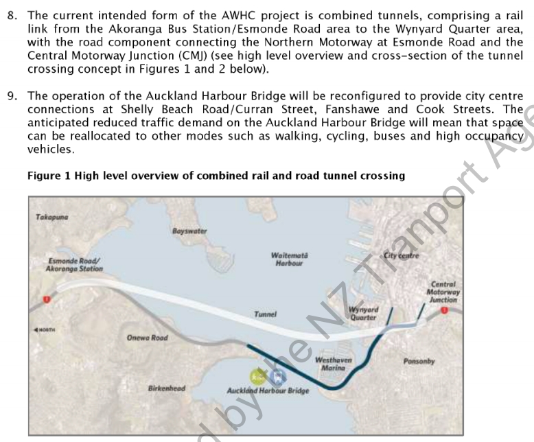
Even if on the same general alignment, building both road and rail as separate tunnels allows us to time each one for when they’re needed. It means we could put the rail crossing and road pricing in and then assess the impacts to see if the road crossing is still needed.
One thing I’ve been thinking about a bit recently is, if we do build a rail crossing to the shore, where should it go. I think that at a high level there are three main options (there may be some variations of each of these). Below I look at these as well as some of the positives and negatives of each of them. In all cases these are not mode specific and I’ve assumed that they would involve the upgrade of the busway. At the city end they would have a station under Wynyard and then travel under Wellesley St to connect to the Aotea station, which City Rail Link Limited say has been “future-proofed for any future decision to create a North Shore rail line“.
The three options are below. Yellow for the tunnel and blue for the surface route. I also haven’t included where the line would go east of Aotea as that’s a discussion for another post.
Northcote
This would see the likely see the tunnel emerging somewhere around the old toll plaza just north of the bridge and then travel up along the eastern side of the motorway, like the southbound bus lane does now, till it reached Akoranga after which it would replace the busway.
Positives
- This would be the shortest and therefore presumably the cheapest tunnel
- It would enable a Northcote Station which would make it a lot easier for people using Onewa Rd buses to connect to head north – for example, if you were living in Birkenhead and working in Albany.
Negatives
- Getting it from the toll plaza to Akoranga may be difficult to consent as it would likely require more reclamation – something that was already controversial last time it was done, for the bus lane.
- Given more than half of the potential catchment is water, there are not huge opportunities for urban redevelopment in and around a potential station site. Also, a station there was proposed for the busway but was dropped after strong opposition from some locals.
- While a rail only crossing is the best option for our next crossing, it’s probably a good idea to leave the ability for another road crossing sometime in the future. This option may rule that out.
- Takapuna would still need to be served via transfer to a bus. Alternatively we could also build a spur but that may complicate operating patterns

Akoranga
This option is same as the alignment for the combined tunnel and would see a tunnel from Wynyard directly to Akoranga.
Positives
- This is the shortest and most direct route. Combined with no new stations it would make for the fastest journey from the shore to the city.
- Space could be left alongside the tunnels for potential future road tunnels.
Negatives
- It would add no new stations and catchments to the network.
- Akoranga has the worst station catchment of any station on the network and most of the immediately nearby land is undevelopable.
- Takapuna would still need to be served via transfer to a bus. Alternatively we could also build a spur but that may complicate operating patterns
- It doesn’t allow for connection to Onewa Rd buses

Takapuna
One of the biggest frustrations with the busway is that it just misses Takapuna which is one of Auckland’s key metropolitan centres. I can understand missing it when we were spending just a few hundred million on the initial busway but If we’re going to be spending billions of dollars on rail crossing, we should consider putting Takapuna “on the way”. Depending on the route, this could also give us the opportunity to add a station at Hauraki.
Positives
- It includes Takapuna on the Rapid Transit Network.
- While not the only consideration, catching the train to the beach would be extremely popular at summer.
- Both new stations could have significant development potential around them (note: there is probably not enough development potential to also have one at Bayswater too). Combined both stations currently have about 10,000 people and 9,000 jobs within close proximity. These could both increase considerably.
- It would also improve public transport for others on the Devonport Peninsula as it would make it easier to connect to a fast and frequent service to the city.
- It wouldn’t prevent a future road tunnel.
Negatives
- This option would require the longest tunnels and be the longest overall, adding about 2km to the Akoranga route.
- The length combined with the additional stations would make it the most expensive and meant it took a few minutes longer than the other options – however, it would still likely be faster to get to the middle of town than it is now via bus. Also it’s worth noting that experience from CRL and from overseas shows that long bored tunnels are not necessarily super expensive but it’s the stations that tend to be.
- Getting the route from Smales Farm to Takapuna could be tricky
- Locals, particularly around Hauraki, may oppose having a station as it will require and encourage urban redevelopment.
- It doesn’t allow for connection to Onewa Rd buses
- We would need to come up with a new use for the existing busway between Smales Farm and Akoranga. Perhaps it stays as a busway providing additional PT capacity over the harbour and becomes the option for those going to the downtown area and Ponsonby.

Personally I would still like to see a new bridge be considered regardless of the option. That’s because one of the best things about crossing the bridge by public transport is you get to enjoy views like the one at the top from Councillor Richard Hills.

 Processing...
The options for going east of Aotea would be very interesting. University & Hospital stations presumably, but then what? Tunnel all the way to Panmure and join the Eastern Busway? Join with the Southern line at Newmarket?
Rapid transit stations should be added where there are already major trip generators and/or big opportunities for urban redevelopment. It is likely that any new line would be incompatible with the existing rail system (so the tunnel under the harbour could have steeper grades) and this is actually a good thing for network resilience.
So stations at the University and Hospital and Newmarket are all no-brainers. The station at Newmarket would be separate from the existing station, maybe on or under Broadway.
After Newmarket is up for debate but I’d suggest continuing south down Manukau Rd. Additional stations could be at Green Lane West (serving Alexandra Park and Greenlane Clinical Centre), Royal Oak and Onehunga. Such a line could eventually be extended to serve Mangere.
I think the best option is Greater Auckland’s RTN map, trains are balanced. 2 lines co-running through the central section. But splitting at Akoranga and somewhere where the northwest line and south Isthmus line would connect.
Only gripe I have is I really want that University and maybe Hospital stations. The uni’s are major transport drivers, and Symonds st is packed with busses in the morning / evening peaks, its pretty crazy to see double decker after double decker disgorging basically the full bus load there.
None of the proposals in this blog post fit within Greater Auckland’s proposed Congestion Free Network 2.0. And that’s ok, CFN was always destined to evolve as different parts of the city changed.
Option C is a strange one, a huge dogleg to get to Takapuna, although it really should be connected somehow, would make it much easier for people from Milford and the Bays to get the bus to a station
Looking at the map you almost would rather want to dogleg to the left via Birkenhead/Northcote/Hillcrest etc because the catchment would be so much greater than Taka & Hauraki
You get the feeling that a spur line from Akoranga to Takapuna/Milford will be the most likely outcome.
That first option could be an elegant Light Rail and cycling/walking bridge, Wynyard to toll both area, convert whole busway to LR. This would be by far the cheapest option, and stunning.
The Takapuna/Hauraki metro tunnel option is intriguing; an actual solution to Lake Rd, ie whole upper Devo catchment would be just a couple of minutes from city or the rest of the Shore.
How to deal with Takapuna means choosing between one of the two core tenants of rapid transit planning:
1. ‘be on the way’ ie don’t do a Manukau City type spur which spilts service pattern, or
2. ‘be direct’ ie take the straightest line possible.
Can’t do both; pick one my friends.
True, but is that town centre worth it’s own spur & station, if that just takes capacity from the core Shore line?
The curve could be a bit more graceful looking. I think this has massive potential though. I wouldn’t be surprised if this is what people that live there would want, a semi solution to their traffic woes without the bus lanes etc etc. One issue is this alignment doesn’t quite go far enough to connect with a potential ferry ( which I really doubt you’d get consent for anyway)
I wonder what would be better overall though, onewa interchange, or taka dogleg. That interchange is so sorely needed. The next question is mode though, I really like Seattle’s light rail, it’s honestly almost on the same level as the skytrain (not quite though) and easier to build.
I’d think Option C would be better if there was an interchange station at Quay Park, with trains from Parnell Station running straight through to Devonport and on to Takapuna.
But I prefer an option A, with a station at the end of Onewa Rd. This would be much cheaper and serve a larger catchment. From what I’ve seen of previous cross harbor tunnel work, the station would need to be below sea level to achieve acceptable grade.
It won’t be trains connected to the current network; that is struggling enough and CRL hasn’t even opened yet; it’ll be a new system separate from our current mixed Freight/Metro/Intercity one.
Connection by transfer like pretty much every city’s urban transit networks.
Rather than trying a difficult dog-leg to get to Takapuna, an alternative would be to add a road-median RTN line from Takapuna-Akoranga-Northcote-Highbury (and eventually continuing on to Glenfield and Constellation to create some “net” in the network.
Good idea, a shore shuttle.
Not every rail line need to terminate in central Auckland
I’d like to see a bridge considered too. It could be a new icon for Auckland if we did it properly.
+1
Honestly the bridge option is lost to me at least. If we can hardly reclaim 3 or 4 meters then there’s no way we could get a full bridge. Plus I think it’d look worse. I don’t know why but the visual of having two bridges at different angles to each other, completely different styles and heights would seem like clutter. Obviously this all objective, and you can’t explain to someone why you like the look of something (or don’t). I know it makes sense from a cost perspective. Also im weird in that I really like going through tunnels so there’s that.
The bridges in the Firth of Forth are a really interesting similar case study for Auckland. They now have three bridges of each engineering type: Counter lever, suspension, cable stay.
Some may say they don’t work together but I like it and like that each is representative of the time they were built.
Side note: they also had to close down the road bridge before the new one was open causing over a month of delays and a much longer detour than Auckland had.
The newest of the three, the Queensferry Crossing is a really nice bridge. The longest 3 towered cable stayed bridge in the world at 2.7 km. Cost £1.3 billion for the complete 22 km scheme.
A new bridge anywhere near the old bridge will never be “a new icon for Auckland” because it’ll have the fugly old bridge right behind it in any photo.
Not if the photos are taken from the Skypath on the old bridge.
Agreed, although I think the old bridge has a certain charm. If you did a full replacement then I could get behind that from the looks and icon perspective. I really like these cable stayed bridges. https://en.wikipedia.org/wiki/Port_Mann_Bridge#/media/File:Vancouver_Portmann-Bridge_2015.JPG
https://en.wikipedia.org/wiki/Cable-stayed_bridge#/media/File:Abdoun_Bridge_(7).jpg
Perhaps you could build a new bridge right beside the old one. And on most perspectives you could design the new one to compliment the old one in its silhouette.
Although I think a replacement is pretty much out of the question from a cost and pointlessness perspective.
The current bridge had a lot more aesthetic appeal when it was just the original 4 lanes. The clip-ons make it look ungainly. I also don’t agree that another bridge would ‘clutter’ up the waterfront. Plenty of cities have multiple bridges of different ages and design which look great. The idea that there should be just the one structure spanning the Harbour is dumb.
Yes the original four lane version looks more elegant. If you could take the clip ons off once a new bridge or tunnel is done it could all look nice together but can that now be done once the “Skypath” has been added on.
Of course the recent damage done shows another reason to keep the clip ons on.
I would like to see a low bridge that people can walk across, cycle across and fish from. Something that would allow regular people a chance to get close to the harbour. They would just have to tell anyone with a mast they have 10 years to choose which side of it they want to be on.
And the sugar company will have to get a super-long conveyor belt.
Think of a public transport bridge that could link the people and their harbour. Do you deny them that so the sugar company can carry on at the wrong location?
To be fair to the sugar company they’ve been there since 1884 and I’m not sure you could call it the wrong location if it is still fit for purpose.
Or people could go out on boats to be close to the water and fish. 🙂
Or, we could reallocate the harbour bridge to more space efficient modes, and create a lovely Westhaven Drive, with light rail and a whole lot of people space… where we can walk and cycle close to the seas level. Glorious.
Unbelievable that they are talking about this. This has been talked about it before. see this https://www.greaterauckland.org.nz/2019/06/05/a-history-of-harbour-crossing-options/
Yes, but first we need to get to the point where they drop the idea of a road crossing
I’m struggling to figure out where you could actually land a bridge on the City side assuming any bridge would need to maintain a certain minimum draft for navigation purposes.
You don’t need to. The old bridge was built to that height to protect access to a future port at Pollen Island. But shipping now uses ships that can’t get under the structure they thought they were future proofing. The only ships going under now are reefers to the Chelsea sugar works, which let’s face it doesn’t belong there anymore and some ships carrying explosives to a magazine at Kauri Point that should have been moved elsewhere 60 years ago. Oh an a few wealthy dudes with yachts.
Yeah, I thought you were a bit salty about yachts in your other comment. Its a fairly accessible sport. I used to have one, cost 3 grand. And if you don’t want the overhead / upfront costs like that, you can join a local club. They are usually looking for people to sit on the rail or pull some ropes. Its really a really fun sport, Auckland has drifted away significantly from the it in recent years though. Although I agree that we shouldn’t be building bridges as high as the harbor bridge, if we were to build a new one. Its way too far on the extreme end of height. It just needs to be high enough so that any conceivable ferry could go under at full king tide. + some safety margin.
Yes like the Sydney ferries. I have nothing against Lasers and 470’s or Optimists. But do we screw up future links to suit a wealthy few who claim rights as incumbents?
Chelsea sugar works provide work and jobs for Aucklanders ,which is far more important than being able to bike or walk over the harbour on some new lower bridge that ships can’t pass under,so get over it. Get on a ferry with your bike, maybe push for vastly improved ferry services and vastly improved ferries that you can comfortably take your bike onto .
We’re addicted to sugar, it will create jobs wherever it is located.
The whole lower walking / cycling / PT bridge is a little bit of a moot point anyway, with the skypath essentially almost being confirmed. And the NZTA heavily favoring a tunnel for PT or cars. Although I mostly agree with you, NZ is going through a real phase where heavy industry is getting pushed out. If we want to import all this stuff instead, then we will have to export something. We already have quite the trade deficit (this year excluded) and a pretty low value dollar.
I think NZTA had some plans floating around for a cable-stayed bridge adjacent to the current bridge at Northcote Point and landing at the eastern side of Westhaven where the northbound motorway tunnel surfaces at Victoria Park.
At a easy 6% grade for light rail or light metro, a bridge need only be 1,500m long to get up to the height of the existing bridge, then back down again.
The harbour is 1,800m wide at the narrowest point in the city, so you can literally land the bridge anywhere you like and keep a navigation span as high as the existing bridge has.
Not sure why miffy is so grouchy about bridges that let boats go underneath, that’s kinda the point…
If Light Rail is the plan then they should be making this decision fairly quickly as they could have been fitting the new Busway from Albany with tracks, buses can drive on them / over them easily enough and means it wouldn’t need to be retrofit.
I prefer option B, feel like the Devonport / Taka board / residents have given up their rights to get platinum treatment since they veto everything that isn’t carparks or making Lake Road into a 20 lane motorway. Make sure his line gets to Albany as quick as possible, re calibrate Albany Roads a little (if possible) and start cranking up development there ala Hobsonville. Add some local amenities (cafes, shops etc that aren’t strip malls) and turn it into a true Town Centre that is pro development.
I have always thought a bridge from herne bay area around the existing bridge to somewhere around Chelsea sugar refinery and then a tunnel through under Highbury centre Birkenhead to Northcote shops and run at ground level to and over the motorway on to the busway, yes bypassing akoranga station but 2 new stations at Birkenhead and Northcote will more than make up and those areas have huge potential for development.
It would likely also require a tunnel under Ponsonby also possibly a Ponsonby station with it.
What modes would you put on that bridge?
Possibly light metro or driverless Metro.
Well there is a designation for a causeway from Meola reef to Birkenhead that was supposed to link into the Western. I’d have to put my nimby hat on if that ever came up for serious consideration.
Whilst getting from one side of the harbour is a huge problem for extra road lanes, heavy rail, or light rail, the first two modes mentioned have another, potentially even larger problem.
What to do shoreside at both ends ?
The motorways leading onto the bridge at both ends are already at capacity.
The Central Rail loop ultimate capacity, will be very nearly fully committed on opening.
Any further harbour crossing cannot be considered in isolation without first considering shoreside connections especially at the incredibly built up southern end, the most densely built up area in the whole country.
I think this favours street running of Light Rail, replacing some buses, through the CBD area and reallocation of road space away from SOV’s as already accomplished in many European Cities faced with similar dilemmas.
Disagree Don. Street-running for a catchment as major as the North Shore would be like running the Southern Line on-street. Cross-harbour rail would be stymied from Day 1 if this is all we design for.
If North Shore heavy rail were to connect into the city rail loop, it would form an extension to the planned Southern-Eastern service which is currently proposed to loop around on itself. Instead of trains arriving via the Southern then looping around to return via the Eastern, they would simply continue to the shore. Usage of the CRL and Britomart would be the same, but with through-services running via one leg or the other, instead of looping-round and using both legs. How and where the NS line would connect into the city-loop is beyond my skill to suggest, except to say that it s a pity provision for such a connection was not planned from the start.
If demand eventually exceeds the capacity of this, then a 2nd CRL of some sort would be needed, but a scheme such as I suggest would allow for a train every 5 minutes and would provide adequate capacity for much further into the future than a service that mixes with pedestrians in the street.
I think you’re probably right that volumes will eventually exceed street running capacity. However, that just requires the tunnel to be built to handle this in the future. It could initially be made up of street running LR, with an additional CBD tunnel being built once demand requires it. This will probably be some sort of Light metro to take advantage of the fact existing busway bridges are already built to take it.
I don’t think it well ever connect into the CRL as this would mean some services missing Aotea and others missing Britomart under your proposal, somewhat defeating the point of the CRL. It’s more likely an underground North Shore line will arrive at platforms below Aotea station running perpendicular to the CRL.
You are right on the demands, not on the outcome. The Southern Line isn’t that busy, it moves less people than the Gold Coast light rail or the Sydney light rail.
@ Riccardo. In terms of daily ridership you may well be right. However in terms of passengers/hr during the peaks (the measure that really matters) I suspect the Southern Line is way ahead of Gold Coast or Sydney LRT. I haven’t got time now to ferret for the figures to validate this, but both Auckland and Wellington have an unusually high “peakiness” which is masked by relatively low off-peak demand when considering daily ridership figures.
The southern line doesn’t even fill it’s 5,000 people capacity in the peak hour. Street running LRT could do 12,000 in an hour based on 66m units at 2 minute intervals.
Street running LRT will probably cope with the North Shore’s numbers for 30 years. In the interim, we can build a NW line or a SE line, or a SW line with the money we save by not building another CRL.
Quick check, and I stand corrected:
Auckland:
6-car CAF AM-unit (max 746 pax) @ 6 tph = 4476 ppd/hr
Sydney SW LRT:
2-set Alsthom Citadis 305 (max 476 pax) @ 15/hr = 7140 pphpd
The twin-Citadis at 15 tph (Sydney Line 2+3 combined) has a significantly greater capacity than the 6-Car AM at 6/hr (Southern Line). However to compare fairly, we should perhaps also count the Southern+Eastern together, so 6-car AM at 12 tph = 8952 pphpd!
@sailor boy. Totally agree. Plus we can incrementally improve the light rail systems by adding more and more transit / signal priority, get rid of more and more busses from the same routes. Put sections in tunnels as required, or build relief lines or bypasses as it is necessary. Rather than build a big heavy rail line that has overhead capacity for 50 years for the sake of future proofing. If the Queen street corridor becomes so successful and saturated with light rail, then you have the opportunity to build another nearby corridor to expand the network. Or replace with better infra as to be decided at the time (when you would know much better than now)
I’ll note that the 2-set Alsthom Citadis 305 models used in Sydney are 67 meters long, which is pretty short compared to the CRL stations, and its not infeasible that with a bypass under queen or alternative, you could extend the platforms around the network and make a 3-set and get an extra 50% capacity.
Link light rail in Seattle is even gruntier. Potentially 3 minute headways, comfortably 193 passengers per car (more with seating changes), up to 4 (29 meter) car sets = 15,400 passengers per hour through a single point.
Long story short, “light” rail can have very high capacity, and potentially having to build more lines / routes is a feature, not a bug
Dave, peakiness is something that flattens out as a network matures. It’s not so much the thing that has to be designed for, as the thing that indicates the network is unable to serve all types of trips.
If we use our money on one (more expensive) line, to address the peak, peakiness will reduce a little, but still remain a feature of the network.
If we use our money instead, on several less expensive lines, to address the need for a network to serve all types of trips, peakiness will flatten out and access for all types of users will become a feature of the network.
Dave B – you’re right, the Wellington rail network especially is very peaky, but that’s not a good thing. It’s basically a one trick pony, with a lot of money having been spent on getting people from the north to and from work each day.
In contrast the road network in Wellington serves many more purposes and is therefore less peaky (it still has its peaks). This is why even in NZ’s best PT city far more trips are still done by car.
Jack, Heidi, Jezza – We have a situation where road transport is not coping during the peaks – especially if growth is to go on occurring as-projected. If we can ‘spread the peaks’ or find effective ways to discourage peak demand on road as well as PT then maybe we can solve this without further major infrastructure. However this remains a big “if”. Prior to Covid at least, the indications were that both Auckland and Wellington are facing a looming transport crunch, which there may be no cheap way out of. The choice is to keep expanding roads, or to develop a PT system that is good-enough to offload the burden from the roads.
Historically, many cities worldwide have met (or preempted) ‘transport crunches’ by building extensive metro networks. For many large cities, their rail systems are now the mainstay without which they could not effectively function. Auckland is ‘tiny-town’ by comparison, but it is on the same trajectory as many larger cities previously were. And although Wellington is even smaller, it behaves as a “slice” of a much larger city where that slice may have exactly the same issues and problems as Wellington does. Overall size and population do not necessarily define the treatment that individual corridors need.
Street-running of rail is not a new thing, but has historically been confined mainly to localized, non-arterial networks. Many cities with metro systems also had (or still have) street-tram networks which fulfill a different function. In general this means short-distance, slower-speeds, frequent stops, and high-capacity achieved through many passengers standing. You don’t expect to travel far under such conditions.
A few examples exist of where street-running systems do achieve high-end capacities of >10,000 pphpd, but I suggest these are not the norm, and the streets they occupy tend to resemble rail-corridors rather than city-streets. This is not to say it can’t be done, but it is far from typical for on-street systems.
If Auckland is to go to the length of building a hugely-expensive cross-harbor rail-connection serving what is effectively a separate regional city, this needs to be a metro, not a street-tram. To skimp on this even as a short-term or temporary measure seems a thoroughly bad idea to me. If the rival scheme is another 6-lane fully-segregated motorway, we need to do better than a couple of rail-tracks in the street. IMHO.
@Dave B – Road pricing would do a lot to “un-peak” the peaks.
“… but it is far from typical for on-street systems.”
Possibly mainly because a lot of the existing systems are quite historical in nature.
@ Dave B (wellington):
The Sydney LRT’s, while crossing road intersections as at-grade with the street, run in corridors that are segregated from automobile traffic.
Light rail can run completely separate from the streets. All light rail is; is rail that does not conform to mainline standards.
My take is that Light Rail is just a configuration of Metro Rail, but without a driverless option, and with some, or all off the route, at grade on existing roads.
The Light Rail proposal to the airport would have about it’s route meeting the criteria to be able to be classified as Metro Rail, running on a protected corridor.
Similarly the existing north shore busway re fitted with steel rails and excluding buses would meet the criteria of Metro Rail.
Progressive retiring of street running portions by replacement with elevated or underground sections will result in a progressive improvement in journey times. Entirely analogous to the recent undergrounding at the city end of a section of the Adelaide O bahn.
Complete the replacement of street running sections and voila, Metro Rail, but until then most of the benifits will have been in place for many years, and that money much better used by laying rails elsewhere.
Dave – your being disingenuous here, the majority of the proposed North Shore and North Western lines will be on a dedicated corridor as you suggest. The only street running sections will be in the CBD.
When the CBD section nears capacity simply (except for the cost) build a tunnel and divert the trains of whatever description into the tunnel and probably make them driverless at the same time.
No jezza, not disingenuous. My concern is that none of such a major route as North Shore rail should be on-street – even the bit from the cross-harbor tunnel/bridge to the terminus (and a dead-end terminus itself is undesirable – like the current Britomart).
I was careful not to mention light rail as being somehow inferior for the task. My concern is over street-running (even just a little bit) being inappropriate for such a route as this, rather than the weights of the vehicles. However I do feel that adding North Shore rail as an extension of the existing rail system carries some significant advantages for regional ‘single-seat’ connectivity, if it can be achieved economically. And this is where I am inclined to rebut some of the claims I too-often hear, to the effect that heavy-rail would be prohibitive because it has to be designed to heavy-freight standards.
I hear what people are saying about starting with on-street sections now and upgrading them later. Certainly this is a strategy that has been followed successfully elsewhere – Karlsruhe comes to mind, where they have now undergrounded their CBD tram-routes. And Don, very interesting to hear about the Adelaide O-Bahn being extended underground, I did not know about this.
My concern over North Shore rail is that this route is too important and potentially too major to slug with temporary weak-spots which may well end up locked-in and regretted for decades, knowing what ‘temporary’ can mean in reality. If peak-demand for travel can be successfully regulated by management- means then I concede that a full-blown metro service may be unnecessary. But the precedent for anything like this being effective in Auckland is currently non-existent, and many of Auckland’s problems today stem from a failure to expand its metro system as the city grew in the past. If there ever was a case for paying more now to better-prepare for the future, I suggest that North Shore Rail is it. This is the stance of the road-promoters who would love nothing more than to ditch rail and build another motorway to the Shore – no expense spared!
I’ll shut up now.
If I remember The Proposed Greater Auckland Rapid Transport Network LRT is a system of two lines sharing the section between a junction at southern entrance to the CBD to a junction at Akoranga Station for a Takapuna spur to the terminus of one route.
The other northern route being the repurposed busway.
The southern routes would be Dominion road to Airport, and the NW busway.
The elegance of this is that passengers disembarking after a journey the CBD will be largely replaced by passengers embarking for their journey away from the CBD. Like the London tube lines.
On reflection, having the section surface running through the CBD to a tunnel portal in the Wynyard Quater is actually an advantage.
These stops will be very busy for embarkations and disenmbarkations. So dwell times here will be a significant part of the transit time through the CBD wherever the stations are located. The time penalties for slower street running between stops will be negligible as a portion of the CBD transit time. The huge advantage is that street level stops cannot be equalled for ease and speed of access.
And surface street stops are so cheap to construct compared to anything else so the money saved can be spent instead on enlarging the network to increase catchment.
Yes Don R, I agree on the advantages of the city surface stops. While the NW line is also on topic at the moment with yesterdays post: For more capacity, flexibility and resilience another line can always be added running down Albert St. This would provide more access and could join to more of a slower all stopping service along Great North Rd etc rather than alongside a more express service on the motorway that would suit those further out west.
Basically we come to the fundamental disagreement about how detrimental on street running would be to a service. There are dozens of examples where it works just great and some very prominent examples where it runs like hot garbage. In my opinion it will not be that bad at all. Signals can change when a tram is about to arrive with timings, GPS, and in street sensors, the lanes that these vehicles operate in would be exclusively for them, or almost (some busses too perhaps). This is effectively separate running. You could even block normal vehicles from accessing these lanes with fences etc along most of the street section. The sole advantage is that its cheaper now which means we can build more, and more quicker which is really the goal. Like I said in my earlier reply building something once and massive is a trade off and usually its better to upgrade every 20 years-ish than build something once for the next 100 – 150 years. Doing a massive capacity light metro system now would not be better in this respect, in my opinion. There are actually not that many advantages you cant get in light rail either. Automated train control is used around the world in light rail systems, once a section is completely grade separated then ATC can be used for closer running and greater capacity and control handed back to drivers when you approach the non grade separated sections. Plus the majority of the proposed routes will be grade separated, Queen street and dominion road are pretty much it.
I’ve posted before – Future tunnel/bridge from PoA land over to Stanley Point/Devonport. Run it all the way up the peninsula towards Takapuna.
Also put in a future teminus station setup on Portside for future Waterfront stadium.
So an 11km long tunnel with 7 stations? Double the cost of any other option and probably 5 times the cost of a bbridge option to cover 15,000 more people and delay everyone else my 5 minutes?
Why? I want to see the entire peninsula rezoned for apartments, but this seems like a pretty extreme method to achieve it.
No not a 11km long tunnel (Absolutely ludicrous to imply that I meant that total distance, and just completely dumb financially)
No, Just long enough to get under the water at either end, then back up towards road level for a PT only crossing be it buses, cycles, trams, LR etc.
Do me a favour – Pull up google maps onto a desktop monitor and move the top half of your monitor over Devonport and the bottom half over CBD. If you draw a straight line from where SH16 ends at the bottom of Quay St straight across to Devonport Ferry terminal you will see that the distance across the water isn’t that much longer than the current harbour bridge/CRL.
Again I emphasise – PT/Cycle access only, no private vehicles other than emergency vehicles.
So your going to spend all that money on tunnelling across the harbour just to run at street speeds along the Devonport Peninsula?
That makes an 11km tunnel seem quite sensible.
Or a bridge
A bridge would be on the seaward side of the port, it would have to be taller than the current harbour bridge to allow modern ships to pass under it. That would make it a pretty steep bridge.
Either way you’re still running light rail at street speeds through the low density Devonport Peninsula.
Another possible alternative route – Wynyard quarter @ Brigham street straight across to Stanley Point @ lookout – This is the shortest possible route from both ends.
Bridge or tunnel – Whichever, but restrict it to PT, cycle and emergency vehicles only at all times.
It doesn’t have to be LR running all the way up the peninsula to Takapuna, we can have priority PT lanes similar to other like Manukau Road, or exemptions for scooters/motorbikes.
So you’re going to build a tunnel or bridge to make all journeys slower than they are today by forcing a whole load of street running? Even if the busway didn’t exist, I’d chose the busway as currently built over your crossing idea.
How would all journeys be slower with one of my outlandish ideas?
You are proposing to take an existing busway that runs direct from Akoranga to the city and replace it with a railway that runs on street through Takapuna and Belmont then via Quay Park before getting to the city. You are slowing down all existing journeys.,
Where did I mention removing any existing busways?
That was merely your assumption.
I’d have the existing busway as well.
How am I slowing down all existing journeys?
Ok, so you’re proposing a multi billion dollar light rail network solely to link Takapuna and Belmont to the city. That seems like a collosal waste of money.
Where did I say it was just Takapuna and Belmont only?
Wow you lot all come across as a bunch of know-it-all, “you’re an idiot” type people.
No wonder this site is never really truly appreciated as best as it could be with all your negative condescending dismissive attitudes…. 🙂
Sorry but that is a really silly suggestion for a whole raft of reasons.
Reasons being?
I understand that we’ve locked in about 1 metre of sea level rise by 2100 already (though I recall the US Army Corp of Engineers thinks 5 and a half feet more likely).
Given we’re talking about 200 year infrastructure, should we plan a route that’s already sea-level adapted?
[*There are of course a range of scenarios, and the IPCC’s most optimistic scenario predicts about half a metre by 2100]
Good question.
And should we plan for ever increasing volumes? What happens to freight volumes in a green, circular economy? What happens to person trips across the harbour if we place our intensification well and if we create the healthy transport system we need?
Yes, if we are going to reallocate away from general traffic, we could run light rail or metro system over the existing bridge (Northern Busway upgrade) by using the very centre two lanes (don’t think there is any engineering reason why we can’t it’s as strong as an ox in the middle isn’t it?). This can join the future city to Mangere & NW proper light rail upgrade as per this blogs CFN2. This leaves 3 either side for general traffic aka present day temp situation.
Tricky bit is a station allowing for good Onewa Rd bus connections so that bus lanes aren’t required on the bridge itself because we are probably running out of lanes. Let’s not forget we will also have the Northern Path/”Skypath” for active modes too. If the NW is running a proper rapid transit system this would also be a relief valve for general traffic taking the Western Ring Route.
Longer term an underground driverless metro system tunnel could be built as per this blogs option “C” above through Takapuna.
The two centre lanes aren’t enough, they’re only 6m wide. In practice you would need the whole centre span for two tracks of rail.
Well I guess you could use 3 of the four which would be plenty of width (I understand you need 6.6 m for two LRT corridors). You would have enough room for 1 general traffic lane or a tidal bus/freight lane perhaps if you had a barrier on the median bits.
I see the original four lanes is a carriageway with of 12.8 m. I’m looking at a moveable lane barrier document and it shows a diagram 3.050 mm each lane as you loose 600 mm with the moveable barrier. Note the clips on are 3,700 mm each.
Could be too much loss of lanes perhaps but one thought is that there could be a bus only (& freight?) lane in each direction full time or just one lane in the peak direction or when moveable barrier is moved. This would give better PT travel (& freight) reliability during hold ups etc.
A variation of option C is to start at Wynyard and travel East under the city with a station at the CRL and university then cross the harbour under the port area with a station at Belmont and Takapuna.
Neville, you and I have a similar idea for alternative route, however I’ve already been shot down in the comments section for a similar idea.
Option A but a bridge…
– lowest cost, shortest route
– doesn’t preclude future tunnel
– allows walking and cycling
If it has to be a tunnel, head through Northcote rather than Takapuna
Are there other means of connecting Takapuna to Akoranga?
There is an open route between the two going via either Huron or Northcoft roads, Over the inlet, then under Barry’s Point Rd. About 1500m.
Shuttle tram? Travelator?
What If we think about this as connecting commercial centres and areas of existing/planned high(er) density:
Starts at Aotea station and head west via Mayoral then Cook St, under motorway and straight line to a Ponsonby station. Tunnel follows Curran St and goes north to align with Woodside Ave (potential station at corner of Onewa Rd with an ok catchment). Station at Northcote town Centre (Kainga Ora / Panuku regeneration area). Tunnel runs under Collage Rd with a slight curve to ANZAC St with a Station at Takapuna (Potters Park). Option for interchange with busway, but keep busway as is with a bus only lane on the bridge.
Total length approx. 10km, 3 key new stations, 2 optional additions. Massive catchments.
Let’s learn from NYC and build 4 tracks from the start.
Allows for express / stopping all stations / freight flexibility etc. in perpetuity.
Thinking out loud here, but why are we limiting ourselves by having Wynyard as the starting point?
If Labour were to proceed with their Metro plan running up Queen St to the airport, what if this proposed line then continued under the harbour through to Hauraki, Takapuna, then further north? Other than dealing with the dogleg from Takapuna back to the busway this would be pretty direct in terms of alignment.
While I think light-rail to the airport is more feasible, on the surface I can see merit in this being one long transit spine from Albany right through to the airport and I feel this could’ve been what really appealed about the Metro plan.
If you mean for a north shore line then that’s silly. We aren’t going to become New York or have close to the demand for New York frequencies especially from the North shore. We would build a section of track at incredible expense that wouldn’t be used close to capacity for at least 50 years (probably ever) and deny the rest of the city any transport upgrades. It would be better to build a smaller more frequent system, and in the future if it were needed build relief lines with greater station spacings, like crossrail in the UK, this would give a greater coverage to the network and give better bang for buck with way less risk. People seem to think its a great idea to build something once so it reaches capacity in 80 years instead of doing upgrades every 20 – 30 years, but in reality that is a fantastical failure of planning and money spending. I agree we shouldn’t re-do stuff every 5 years with slightly higher capacity, but having such latent capacity and narrow network coverage for such a long time wouldn’t make any sense either.
This was supposed to be in response to Tony above.
So many options and variations for a north shore line especially when thinking of expansions at either end.
One option that is more expensive to build but would serve Takapuna well but save on running costs is a fully grade separated driverless system all tunnel & underground stations from Aotea to Takapuna. Optional extra alignment to pass under & connect with a new or future Onewa station & also the Akoranga one.
If you’re advocating for a Takapuna route then you might as well go under Bayswater which would not only reduce the costs of the tunnels themselves (vents emergency access etc), would allow for redevelopment of Bayswater into medium/high density (with a station there) it would also solve the Lake Road/Devonport traffic problem. Bayswater is ripe for redevelopment being physically so close to the city but currently much further due to backtracking through Takapuna.
A Takapuna spur isn’t a problem if they build four tracks. Ideally six tracks would allow a third route coming in from west of the motorway. The North shore will require a full network at some stage in the future .
I think the best way for a number of reasons to provide 4 tracks underground is actually 2 parallel double tracked tunnels.
Resilience is improved, evacuation options enhanced, and volume needed to be excavated reduced. And the biggy, the expenditure is staged .
Does this mean that we have abandoned Mad John T’s ridiculous promise to build a 18 lane clip on to the existing harbour bridge, 100% paid for by Wellington ratepayers and built in one afternoon, with no disruption to the existing traffic??
See: https://www.stuff.co.nz/national/115058488/john-tamiheres-18lane-auckland-harbour-bridge-plan-would-be-costly-and-disruptive
Will the new tunnel under the harbour stop off at Waiheke Island? This would allow the citizens of The Republic Of Waiheke to ride their rick-shaws into the CBD.
Not sure why we would remove perfectly acceptable transport routes to replace with something else – why not keep both, hear me out. There is no point in a half baked solution that doesn’t future proof for the next 50-100 years (minimum) spend the money now, it is only going to be more expensive due to the miracle of inflation.
New Rail Link – From the new Aotea Station, to a new station (maybe) in Wynyard Quarter (1) (to link this area with Auckland and South via the CRL), from Wynyard, North to Highbury/Birkenhead via a tunnel, (2) through to North Northcote/Hillcrest (3), through to Glenfield etc… The catchment there is deep in congested road territory, plus a huge amount of intensification options, plus you are taking cars off the commute in to the motorway, i.e. remove cars from the suburbs and feeder roads rather than compounding the problem. The options to develop this further north are endless and allow for many additional spokes, e.g. Northern Northcote to Takapuna. Highbury/Birkenhead out to Birkdale + Beachhaven. With a Taka spoke, this would connect this whole area cleanly
Keep the Northern Express route – the feeder roads are already well developed with bus routes, these buses will eventually become auto-driving, electric, frequently commuting buses – let this play out, why remove this bus route. If you take all the back suburbs off the motorway it is a win win for the existing motorway commuters and those who no longer have to commute to the motorway.
Replace two Harbour Bridge lanes with the sky-bridge for foot traffic and bikes if you must.
I am assuming your new harbour tunnel is rail only?
Its adding no new car capacity and in fact, reducing it via reallocation of lanes on the AHB. You’ll get slaughtered by a host of ratepayers and councilors, despite me endorsing it wholeheartedly.
KLK – I realise you get this, so read the below noting the initial disclaimer.
The focus should not be how many more cars can we get on the road, it should be how to get get people from A to B effectively. Cars should be the last option.
Adding to my above rant, to help fund the cost of such infrastructure, I would have the developers and land owners, who benefit enormously from a value uplift (having modern public transport at their door step), pay for it in the form of [development contributions, “DC”s] as land is intensified. The DC increase could be tiered based on proximity to the station, i.e. <10mins, <20mins (walk) etc and paid for as the land is intensified, (there are flaws to this, but as a high-level concept – this is similar to the Japanese rail model). AT should own the stations, and also develop these extensively, for example the "mall" in Highbury, could be several floors of retail and then multiple floors of apartments, being a few minutes train ride to the city – this would be prime real estate. This could be repeated at every station, and every area that benefitted from the value uplift (efficient rail would bring, including the business's with more foot-traffic) should pay for it.