While in general I was somewhat critical of the National Party’s recent transport announcements, their commitment to completing Auckland’s rapid transit network was a huge positive and something that I could not have imagined a few years ago.
The second project I am announcing today as part of National’s Delivering Infrastructure Plan is Auckland Rapid Transit. We will measure our progress against those goals, of 30 minutes to get to work and one hour to get across the city, that I mentioned earlier.
Auckland’s motorway network is now nearly complete, thanks to National. The motorway network will remain absolutely essential in the rapidly approaching era of zero-carbon, self-driving, electric and hydrogen cars and trucks. Today I am announcing that National’s Plan is to also complete Auckland’s rapid transit network.
At a high level this is really good. There’s recognition that rapid transit plays a critical role in moving people quickly and efficiently around Auckland, and also recognition that it must come together as a network. Many of the problems with the development of light-rail over the past few years is that it seems the Government forgot that it forms part of a wider rapid transit and public transport network, and needs to do a whole variety of different jobs – not just quickly link a few people from the city centre to the Airport and back.
While saying the right thing at a high level, National’s transport policy then goes and undoes a lot of that good work through a whole pile of ill informed reckons about the merits of different modes for these corridors.
We don’t support light rail. National believes light rail will be to the 2020s what monorails were to the 1980s. We do support completing Auckland’s existing train and bus system. We support the vision of Len Brown’s Auckland Plan of 2012.
I am announcing, therefore, that there will be rail to the airport from Puhinui, starting in 2026, and then up to Onehunga, to create a rail loop. This was the plan for Auckland for decades, as Mike Lee will tell you.
Rather than just doing a third main rail line Quay Park to Wiri, we will do the third and fourth at the same time. This will allow the separation of commuter and freight traffic, and for express commuter services and regional rail. In the 2030s, we will look seriously at a new rail line from Avondale to Southdown, which would have major benefits for freight.
I am also announcing today that Phil Twyford’s Ghost Train will be replaced by rapid buses or trackless trams to Onehunga. National will also build the eastern busway to Botany and the northwestern busway to Hobsonville.
![]()
There’s a lot to unpick here, but to start with it is very odd to see the National Party mentioning Len Brown and Mike Lee here – the very politicians they fought so hard against in the early years of Auckland Council. There are also a number of lines missing, lines that National agreed to in their 2016 iteration of ATAP. The notable bits missing are the crosstown routes of Upper Harbour, New Lynn to Onehunga and Botany to Manukau.
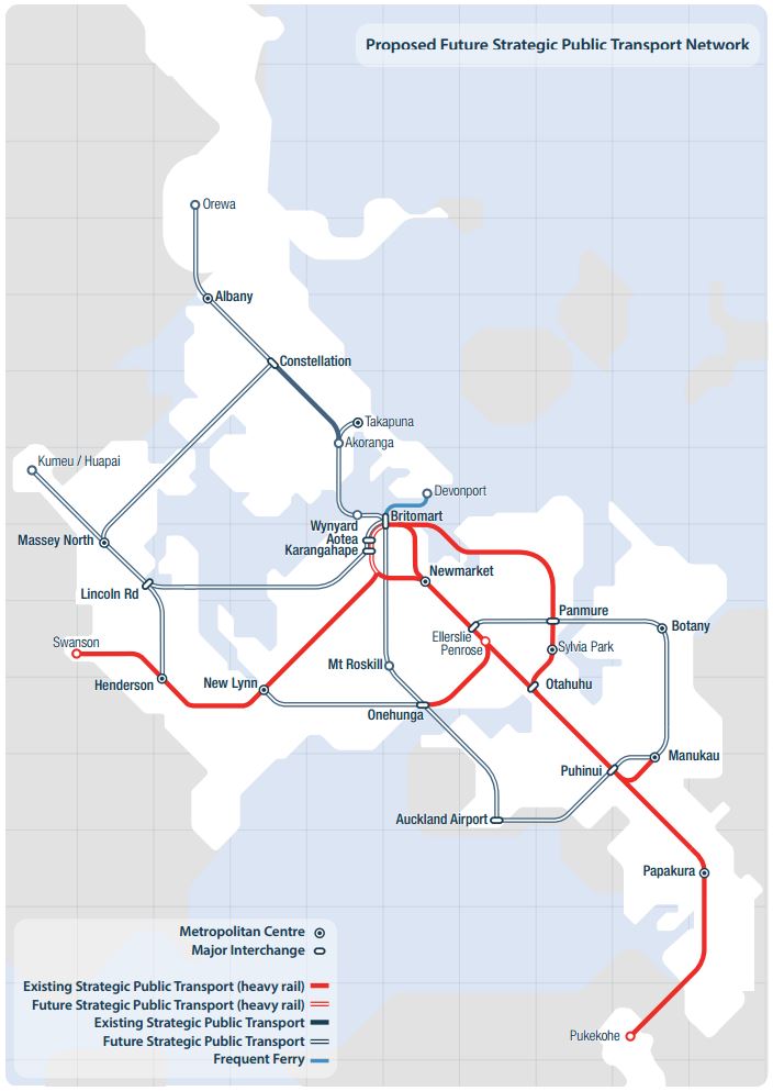
The 2016 ATAP Strategic Public Transport network
Perhaps what’s most frustrating to me, and something that has been happening for some time, is that different rapid transit modes have become increasingly politicised. Heavy rail, light-rail, light-metro or bus rapid transit shouldn’t be an ideological expression, they are all simply different ‘tools’ for delivering rapid transit and each have their strengths and weaknesses.
As I discussed in October last year, the right mode for a rapid transit corridor will likely vary according to the scale of demand and the corridor’s characteristics. In some situations, bus rapid transit will be the right mode – because the level of demand might be low enough for bus volumes to remain manageable, or there might be sufficient space to accommodate very high bus volumes without hugely negative impacts or massive cost. In other situations, demand might be extremely high and heavy rail becomes the right answer, especially if there’s an opportunity to unlock latent capacity in the existing heavy rail network (e.g. City Rail Link). However, building new heavy rail corridors is likely to be extremely expensive and difficult but if demand and/or corridor constraints are too high for bus rapid transit then surface level light rail can be a really good option.
I put together a table to help illustrate some of these different strengths and weaknesses:

What’s important for rapid transit is not the specific mode but that the various routes come together to form a coherent network. The RTN map was originally introduced in the 2016 ATAP but the 2018 version took that a step further and showed – at a network level – the likely future mode of each rapid transit corridor in Auckland.

There’s a nice logic to much of this map (which is very similar to our Congestion Free Network we developed in 2017). The cross-town corridors like Henderson to Constellation, New Lynn to Onehunga, Airport to Botany and Botany to Ellerslie/Penrose are suggested for bus rapid transit – because it is generally the cheapest way of delivering rapid transit and these corridors are likely to have lower demand and there are fewer corridor constraints such as needing to run through on city centre streets. Many of the ‘advanced bus’ ideas that National suggest for Dominion Rd would work well on these corridors.
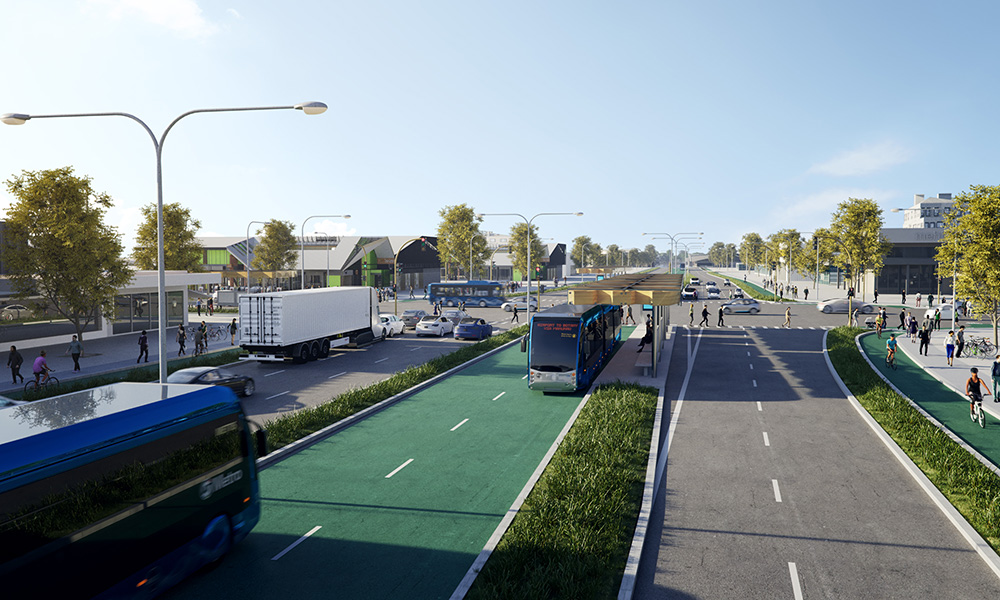
The proposed Airport to Botany rapid transit route using electric, high-capacity articulated buses to provide a near light rail like experience
Improvements to the heavy rail network are predominantly focused on getting more out of the lines we have today, such as the third/forth mains, better signalling, improved reliability etc. – because building new lines will be costly and difficult.
The third network – light-rail – provides the three big, new corridors to the north, northwest, and to the Airport. This third network serves big radial corridors that are likely to have high enough demand in the long-term and/or corridor constraints for bus rapid transit to struggle.
As I mentioned earlier, the Government hasn’t exactly covered itself in glory either when it comes to making sensible mode choices. A lack of evidence in the mode conversations around the light-rail project has led to a bizarre situation where it seems like the coalition is split three ways, with Labour preferring a ‘light metro’ option, the Greens preferring light-rail and NZ First preferring heavy rail.
Now this doesn’t mean the map above is perfect and might not need to evolve over time. I remain convinced that light-rail is likely to be the best mode for City Centre to Mangere, in part because we’re also building the Airport to Botany route. However, I’m not as sure this will be the case for the Northwest or North Shore. These two corridors have higher long-term demands and as they will mostly run next to the motorway they may well be suited to some form of light-metro. I’ll expand on this idea in the coming weeks.
For now though, I remain a mixture of mildly optimistic, confused and annoyed by National’s rapid transit proposal. Mildly optimistic because their high level messaging is good – Auckland’s motorway network is now basically done and the city now needs to complete its complementary rapid transit network. Confused because it’s hard to understand the logic behind some of their decisions about mode for the different corridors – especially their preference for bus on Dominion Road when many studies have shown that doesn’t solve the problem, or heavy rail to the Airport where once again years of analysis has shown why this mode is so expensive and difficult. I’m also annoyed about the poorly informed ongoing arguments about mode and the absence of evidence our transport agencies have brought to this conversation. It’s now more than two years since ATAP was completed and it doesn’t seem like the diagram above has really gone anywhere or been further developed – leaving a vacuum of information which has been filled by uninformed reckons.

 Processing...
I strongly favour heavy rail both to North Shore and the Northwest. Firstly heavy rail to North Shore will be our main opportunity to build CRL2 (a Wynard Newmarket tunnel) and offer competitive speed all the way to Silverdale (and in the more distant future to Wellsford after the line heads west from Silverdale to join to North Auckland line. Is Aotea to Wellsford in one hour feasible?). Heavy rail to the Northwest can feed into the exisiting North Auckland line and again provide another cross CBD tunnel, this time from around the strand station underneath customs street to a station next to Britomart to Wynard then head southwest with underground stations in Ponsonby and Grey Lynn before running alongside the NW motorway to Kumeu. Imagine the rail network around the CBD/inner suburbs if these two heavy rail lines were built. We could become like Sydney.
We could also go broke. We have to find solutions that are affordable or we’ll end up another three years down the line (no pun intended) having the same conversations all over again. And our rapid transit network will be no further advanced.
I’d love it if politicians stopped treating Auckland public transport like some sort of Sim City exercise and got down to putting the RTN in place ASAP, even if initially some lines are bus with 24/7 bus lanes and signal priority and pre-emption in the short term pending an upgrade. As passengers, that’s really the most important outcome and it’s critical we keep that front and centre. .
Govt needs to fix traffic now with RTN.
Or we just pony up and build the infrastructure that we need. Typically in NZ we never look to the future and build cheap, the existing CRL build is a great example of this, they should have built 4 tunnels instead of 2. It would have been good having them ready and waiting for when they are needed.
Mate ya dreamin.
But seriously, everyone knows the coolest option is to have heavy rail zooming through tunnels all over the city. But that is not based in reality at all. There are limited resources and if the new hr scheme won’t be saturated at any point in the foreseeable future, then it’s best to save the money and spend it on cheaper, rapid transit, that goes to significantly more places.
*your new heavy rail scheme
Mainline systems aren’t always a better option for rapid transit than a metro or light rail system anyway.
They are constrained to larger chords and larger stations, which can compromise the service they deliver. Plus they have gradient limitations.
When you look at rapid transit systems built to the mainline specifications such as the system in Hong Kong or the RER lines in Paris or London’s Thameslink & Crossrail: They really more deliver people to transport nodes in the CBD, from which a lot of commuters transfer to another mode such as a metro line, tram or a bus to actually get them to where they go.
Having the Northern busway upgraded to a light rail or light metro offers a lot more in possibilities for the cbd end in terms of station locations and alignments for any extension.
That would be impressive but expensive. There’s nothing stopping us running light rail to the North Shore and NW and putting tunnels in the CBD at a later date if there are capacity issues.
I would suggest a light rail tunnel under the Harbour from a new bus interchange at Onewa with stops at Wynyard, Victoria Park, and Aotea would be significantly more practical than a heavy rail line that might only have two stops and be far more expensive to both tunnel and retrofit the busway. Also nothing stopping you from extending the tunnel to Newmarket via the unis and/or hospital.
There is no practical speed advantage in using mainline garage over a light rail gauge for suburban rail given the station spacing and accelerations, needed alignments, etc. If anything, a light rail system could provide a faster transit given it could have much quicker acceleration and deceleration from speed.
Given that there is no need for a future North Shote rail to carry any freight; there is NO reason to spend the extra billions and make it to mainline specifications.
The CRL is costing over $4b, and being the first this is the “easiest” one: the shortest route, the easiest alignment, the biggest benefits.
A second CRL doesn’t get the benefit of the ‘easiest’ corridor, it will have to be longer, more constrained, harder to build. If you think building Aotea station is a nightmare, try building another station underneath Aotea while you keep it running. The second CRL would cost at least twice as much as the first… and a third?! Twice as much again. You’ve spent $20b before you’ve even made it out of the city centre, let alone the astronomical cost of making it to a wellsford or kumeu.
Urban heavy rail is like urban motorways, the network is done and improvements will only be around adding track/lanes in places and tweaking junctions/intersections. There is no good case to build new heavy rail or motorways within Auckland. Other options will always have bigger benefits with less cost and impacts.
Avondale-Southdown?
There’s at least a freight argument there. Heavy rail to just serve solely residential areas is just feeding into the idea that some parts of Auckland have to have the biggest and best solution, usually before anyone else gets anything that they already have *cough cough NEX*
I think the North Shore would suit light rail & would good give good flexibility, bang for buck, to extend beyond or to the left and right branch lines into town centres if necessary in the future.
Sorry, but we absolutely do not need underground stations through any inner suburbs. Light rail is so much cheaper to implement and so suited to our city with wide arterials which used to have trams going down Jervois Rd, Great North Road, New North Road, Sandringham, Dominion, etc etc.
There is zero point in tunneling. We need less cars on the road anyway for climate change targets not to mention reducing congestion, so why the expense of burrowing under the roads.
Light Rail needs to be Auckland’s future in the inner suburbs.
Those roads aren’t that wide. They didn’t have a lot of vehicular traffics back then either. And now we have stupid very low speed limits which does not help traffic flow, adding teams into the mix is going to create chaos.
They’re wide enough for light rail.
Having less traffic again would be a great thing. I don’t know anyone that wants more traffic.
Dominion Rd’s speed limit of 50kmh doesn’t seem very low to me.
We need to get it out of our heads that people driving cars have some sort of G-d-given priority over those who are not. They don’t, quite the opposite in fact.
People on foot spend money in shops, people passing through in cars do not. People wanting to get to their job in the city should be taking PT, end of story. Amazes me how many people still drive in to the city when the alternatives are there pretty much everywhere. Light rail is a very good answer to our increasing population density. More roads for cars is not.
The map suggests a trip on the Botany bus way to Manukau and the Airport would be quicker than travelling via Panmure then train. But I am not sure how much patronage the bus way would pickup along its length or whether it would be significantly faster than just catching one of the local buses which already travel to either Manukau or Botany given there would be an additional change required in most cases. Presuming the bus way runs on Te Irirangi drive which won’t have many walkup passengers.
Looking at National’s map makes me wonder if they’d draw a road network like that, requiring drivers to come a long way back into town from each direction before they can change onto a different road.
It looks like a map made by someone who thinks public transport is something people use for maybe a commute in and out of town, not someone who uses public transport for trip-chaining in all sorts of directions for multiple jobs, errands and caring responsibilities.
But I suppose National can only work with what it knows.
I am not defending National but if you are using local buses to do your life in off peak time the current setup isn’t bad especially if your not working or if your working locally with short or convenient hours. However if your working a full day things are much tougher. It just grinds you down especially if you have a physical job. Hence the park and rides which National is promoting. And then there is the airport thing and transfers. For the public transport uninitiated transfers are a big thing my brother who lives in the South Island and visits Auckland a couple of times a year is clearly in the one seat ride camp. I have explained the Puhinui transfer too him a number of times pointing out the simplicity of piggy backing onto an existing train network and the lower frequency which will be necessary if we have to have dedicated airport trains and the difficulty, disruption and shear amount of time it would take to build a Puhinui link. And not to mention that the fare for the train will be at least double if not more than train and bus. But he still doesn’t get it. I expect when Puhinui is up and running next year and the naysayers get to use it there will be a massive “Road to Damascus moment for a sizable portion of the skeptical public. Some may have to be lead by the nose though so maybe at its inception one free ride too or from the airport should be given to all incoming passengers and Auckland ratepayers.
We really shouldn’t design Aucklands mass transit system to suit South Island brothers who travel here a couple of times a year. We should design it for Auckland residents who travel here a couple of times a day.
Local buses to do your life in off peak time — wait, what? I guess it may be OK on the west half of the isthmus, but that’s it.
PT is kind of OK for commuting into the CBD, but I can 100% assure you that for daily errands, having to rely on PT is a crippling limitation.
Not for me on the north shore. I have a frequent all-day seven days bus on my doorstep which goes direct to takapuna, browns bay and Albany, which also connects to the busway which runs super frequently almost 20 hours a day.
I get it’s not great all over, but there are big chunks of the north, east and south that also have really good buses now, not just central to downtown.
Royce, there are issues at peak (overcrowding, slow journey legs due to general traffic, air pollution from congestion). There are different issues at offpeak (infrequent services in many places making multiple leg journeys hideous). And there are major issues related to the deficiencies in the street environment for people approaching the stops and transferring between services.
People trying to get between daycare, multiple jobs, shopping and visiting sick relatives catch ALL of these issues and are far worse off than those who just use public transport to commute.
National’s plan, compared to ATAP, worsens these issues by focussing on radial services without all the required rapid crosstowns. This isn’t a network, and it’s a major flaw of National’s plan. Unfortunately, it’s not rare. It’s a flaw that arises whenever people don’t understand networks and don’t understand the equity issues involved in planning transport.
As for p’n’r (“passenger numbers reduced”) – the evidence is they are a very poor use of money and land except on the very outskirts.
No plan should prioritise people who visit twice a year over our people’s daily transport needs. The occasional taxi ride by people who don’t get public transport is not going to break the city’s carbon budget. But failing to provide a functioning network for day-to-day needs is, and creates transport poverty, to boot.
I am not advocating for a one seat train ride to the airport in fact the complete opposite just highlighting the beliefs of non public transport users. I wonder if you or Ricardo actually read my post.
Royce, you replied to my post which was about the map with a road analogy that it’s like “requiring drivers to come a long way back into town from each direction before they can change onto a different road.”
You brought up off peak use compared to commuter use. Since you were replying to my post about the map, I assumed you meant that lacking the crosstowns and focussing more on the radial routes in and out of town, will better suit the people “working a full day” for whom “things are much tougher. It just grinds you down”.
Sorry if I misunderstood, and you weren’t referring to the map… and weren’t replying to what I’d written.
Good post, thanks Matt. I agree that National is missing some of those key links – ie extension from Onehunga to New Lynn and from Puhinui through to Botany. Seems so obvious that I don’t know why they are being blind to it – plus trying to swap modes on the Botany side would be much harder than the Congestion Free Network plan yo guys have developed. I guess just a question: what plan has Labour committed to (I know the Greens are on board with the CFN), but what about Labour? Can anyone confirm?
They committed to the CFN last election. Perhaps a more better question this around is ‘why should we actually believe you?’
Thanks Matt, very good even summary.
It is obvious that the official ATAP map is significantly better than the much more limited Nat one with its needless gaps: a clear illustration of why mode-first thinking always leads to a poorer outcome!
“National believes light rail will be to the 2020s what monorails were to the 1980s” – yet they also like to call them “trams” when it suits, which are something much more useful than monorail ever was.
In reality a lot of these types of statements are meant to be stupid because that is the type of voter they are appealing to. It works for Trump.
Also maybe when National say “Light Rail” they mean “Street Level Light Rail”. I can see why they may oppose that (potentially removes space for cars).
And yet, they’re referred to as trams in Melbourne and nobody has a problem with that.
They are trams in Melbourne, almost all of the network are legacy tram lines. Melbourne only has two modern light rail lines, both from the late 1980s, which are indeed called light rail locally.
The Burwood Road line was built (or extended) to light rail standards in the 2000s.
https://www.google.com/maps/@-37.8214286,145.0254843,3a,75y,293.43h,90.26t/data=!3m7!1e1!3m5!1sYHRv_LxNsHqEyluPNoB5MA!2e0!6s%2F%2Fgeo3.ggpht.com%2Fcbk%3Fpanoid%3DYHRv_LxNsHqEyluPNoB5MA%26output%3Dthumbnail%26cb_client%3Dmaps_sv.tactile.gps%26thumb%3D2%26w%3D203%26h%3D100%26yaw%3D332.17648%26pitch%3D0%26thumbfov%3D100!7i16384!8i8192
Really Geoff? This doesn’t look much like light rail to me.
He means the Vermont South extension on burwood Highway, which is street median light rail segregated track. Not a terrible example of what dominion road could be. However is the last quarter of an otherwise old school tram line, and still uses tram sized vehicles with no signal priority, and has no real platforms with street level boarding, so debatable whether it counts as light rail overall.
Actually I believe Geoff is referring to the extension of route 75 on Burwood Highway – see https://www.google.com/maps/@-37.8517011,145.1287362,3a,75y,270.95h,84.32t/data=!3m7!1e1!3m5!1sVf4uBDkUP7XfiLE5eU8BHg!2e0!6s%2F%2Fgeo1.ggpht.com%2Fcbk%3Fpanoid%3DVf4uBDkUP7XfiLE5eU8BHg%26output%3Dthumbnail%26cb_client%3Dmaps_sv.tactile.gps%26thumb%3D2%26w%3D203%26h%3D100%26yaw%3D59.231644%26pitch%3D0%26thumbfov%3D100!7i16384!8i8192
Somewhat confusingly, Burwood Rd and Burwood Highway are entirely separate roads; Burwood Highway becomes Toorak Rd as it approaches Inner Melbourne, while Burwood Rd lies a few km north of Toorak rd.
That being said, route 75 actually manages to travel down both Burwoods, running as a separate ROW on Burwood Highway before turning into a more traditional tramway and taking a somewhat convoluted route through Camberwell and Hawthorn to reach Burwood Rd.
Wiki: The basic concepts of light rail were put forward by H. Dean Quinby in 1962 in an article in Traffic Quarterly called “Major Urban Corridor Facilities: A New Concept”. Quinby distinguished this new concept in rail transportation from historic streetcar or tram systems as:
– having the capacity to carry more passengers
– appearing like a train, with more than one car connected together
– having more doors to facilitate full utilization of the space
– faster and quieter in operation
By the way I didn’t mean to imply that all National voters are stupid, just that this policy is designed for a particular target demographic. Not everyone that votes for a party will align with that party’s target demographic.
National will be hoping their voters are unaware of the large number of LR/tram lines being built around the world.
Isn’t the target demographic for National voters still mainly just the cow-cockies? Farmers = blue = conservative with a correlation that is probably near 90%. As New Zealand steadily urbanises, and the amount of people left in the countryside gets smaller and smaller, the National vote gets reduced as well – except for the rich Auckland eastern suburbs of course. But it’s a problem that Collins et al will be facing – the Bill English / Jim Bolger / Gerry Brownlee option of appealing to the farmers really isn’t going to be working any more….
Where do Nats plan to build this Ellerslie terminus for connection to an eastern bus link ? There’s simply no space left there that’s practically accessible to the existing train station for that route.
Would the “Race Course” do?
Expensive version is you could build it over top of the motorway.
“The third network – light-rail – provides the three big, new corridors to the north, northwest, and to the Airport”
But this contradicts your own belief that each mode has its own strength or weakness, so why do you support it when it has such strong weaknesses?
Right now, in 2020, the SH16 commuter belt extends from Auckland to Helensville. Right now, in 2020, half of that commuter belt, from Kumeu to Helensville, has rail in place, and is in fact being upgraded as we speak. Furthermore, it’s very direct, being a shorter route than SH16 itself.
Yet you want to build light rail over the other half of the SH16 commuter belt, from Auckland to Kumeu. 1435mm gauge ending at Kumeu where the 1067mm gauge begins. You want a continuous rail route along the SH16 commuter belt, but with a good ‘ol fashioned 1860’s-style break-of-gauge transfer station at the midway point.
Ditto north – whatever you build to Orewa will eventually extend to Warkworth, and then eventually extend again to Wellsford. Just six weeks ago the council up north identified Maungaturoto and Kaiwaka as locations for commuter rail stations by 2030.
In both instances it makes sense to build the northwest and north lines either as 1067mm heavy rail, or 1067mm light rail that could be used by light rail vehicles in the Auckland area, but also be accessed by long-distance tram-trains.
1435mm light rail northwest and north would be seen by future generations as a mistake made by our generation. They would be struggling to understand why we inserted the different track gauge within an established network of another gauge where having the same gauge would have created a useful network.
Let’s dump the mode-bias and plan for the future when commuter rail will effectively extend from Maungaturoto to Hamilton.
You’re overemphasising the importance of the commuter belt west of Kumeu and under-emphasising the importance of it east of Kumeu. The section east of Kumeu has a much greater population and will continue to do so in the future.
LOL, so it’s going to run to Maungaturoto but not to Whangarei or Tauranga!
The population difference beyond the Kumeu section is going to be vastly different to the city side section, so a transfer is fine. The inner NW (light rail) line is likely to end up with 5 min frequencies, yet beyond that I can’t imagine it would.
Err slight difference Geoff, the half of the corridor from the central city to kumeu has 200,000 people living in it, and around a third of the Auckland regions growth planned for the next three decades.
The next half of the corridor out to Helensville has 4,500 people in it, and no growth.
Why would you cripple the first half with the legacy system of the old freight line running in the second.
“Why would you cripple the first half with the legacy system of the old freight line running in the second”
You wouldn’t be, light rail can still be built to Kumeu. Just make sure it’s gauge compatible for tram-trains. There’s a wide range of metre gauge trams/LRVs, so it’s not difficult to build them for 1067mm.
Do we know what gauge light metro is going to be? I understood the NZ Infra proposal was 1067mm, but I’ve not heard what gauge NZTA were looking at.
I would be very surprised if either proposed anything other than standard gauge, for standardization, with third rail power, given the amount of tunneling involved.
The infrastructure speech began by painting a picture:
1) Congestion and infrastructure crisis in Auckland caused by decades of short term thinking. It takes us too long to do anything. Just in time approach. We build things when we need them and generally build cheap. In practice just in time means too late, sometimes much too late.
2) It was forecast in 2004 that we would reach 5 million by 2050 but we got there this year. Transport planning from 16 years ago is out by 30 years.
3) Pledging to transform upper NI & Auckland, and get projects built before a crisis, providing a 20 year pipeline of work.
Some comments above talk about cost but if the goal is to achieve an average 30 minute commute and 1 hour to cross the city, deliver projects before a crisis and build for the future, its not going to be cheap. This might also be driving some of the one seat thinking, where changing between services might make achieving the 30 mins hard (in spite of a service being less frequent). Also the choice of “heavy rail” with a dedicated corridor vs street running LRT. Clearly there is a lot of detail that would need sorting out but the vision can be reasonably understood.
When other parties offer their alternatives it’ll make for an interesting comparison around what the majority might achieve. A 4th main would be a good start.
I can’t see much in National’s plans that’s a one seat ride that isn’t in Labour or GAs plans. The exception might be say GI or Panmure to the airport, however that is balanced by the loss of Mt Roskill to the airport.
I agree 4th main would be good but given it would likely delay work on the 3rd main, I’d prefer they just get on with the 3rd main for now.
Wouldn’t it be easier to do both at the same time , as when/if they do the 4th main parts of the 3rd main may have to be closed while the earth works are done in the tightest sections ? .
Possibly easier in the long run but the delay to this long awaited project is not worth it in my opinion. We needed the third main a few years ago, lets not delay it any further.
If we wanted to stage things cheaper and not make LRT about the airport so much. We could extend the Botany to Airport busway line up via Onehunga to Mt Roskill. This could meet the LRT from city down Dominion Rd.
You could take the bus line into Mangere Bridge down Coronation Rd, probably quite wide enough, taking out on street parking. Back onto the motorway with bus only lanes (so no additional bridge needed). Through Onehunga connecting with HR station & bus interchange could be a bit more of a challenge to do efficiently.
Now I can’t stop…could have the flex of taking off purpose built if any busway on SH 20 through Carr Rd and/or further to Stoddard Rd, up Richardson Rd even as far as New North Rd. I’m sure that BP station could be converted into a bus turn around/station. 😉
There are already bus lanes on either side of the Mangere Bridge. The buses I travel in don’t use them but they are there. Maybe they get used at peak times. The problem is the bus getting on and off the motorway. If the busway to Mount Roskill was to bypass Onehunga altogether you could have a pretty speedy trip to the Airport. The other thing would be if the passengers for Onehunga and Mangere Bridge, Mangere Town centre etc went to motorway bus stops instead of the bus coming to them. Of course there would be safety issues which would need to be addressed. Actually I can’t see why light rail couldn’t run over the bridge.
I’m sure at peak and or during disruptions the bus lanes would be used.
Getting on the motorway not so bad but yes, getting off the motorway heading north into Onehunga looks difficult with what looks like no more room than the existing one lane on Harbour View Rd in that direction that goes around under the bridge.
From Onehunga north best to use a Princess St and beyond proper busway like the LRT alignment was proposed with the next station at Hillsborough Rd. Would want some good walking etc links to this station to the surrounding areas.
Plenty of options in staging though with a no new bridge option. I don’t think LRT can go on the existing bridge for some reason from memory…or maybe that just assumes not taking any lanes off general traffic.
Would the “Race Course” do?
There is an area outside of the racecourse where they have the weekly car sales they could use and between Greenlane and Ellersile there is an old platform that could be used to get to the buses ?
Sorry about that irrelevance.
Like your ideas Grant.
The completion of the Botany to Airport bus system is likely to be operational before anything happens with the additional heavy rail links to Wiri so we will have had a chance to see how the Puhinui interchange is working and it is possible that will serve for a good number of years before anything more substantial is needed. Particularly if we take climate change seriously the passenger numbers to AIA may no longer be the focus, but those working/commuting there could well be the majority of passengers if they aren’t at the moment.
The present bus system from Papatoetoe to the airport works fine but it Botany to Puhinui will be much more direct with fewer stops.
I’ve seen a, ahem, light discussion about what we, in the comments section, would prefer to happen. I will join that discussion:
1) LRT solution for Dominion Rd in line with the original AT proposal
2) Light Metro down Manukau Rd to go to the Airport, with four stops in the South West in addition to the Airport (Favona, Mangere Bridge, Mangere and Ascot)
stops per: https://i1.wp.com/www.greaterauckland.org.nz/wp-content/uploads/2019/10/Light-rail-delivery-without-NZ-Infra.jpg?ssl=1
Manukau Rd per: https://www.greaterauckland.org.nz/2019/11/04/if-light-metro-is-the-answer/
(Why do it this way? It’s pretty clear that we’ve lost the ideological Airport battle. Best outcome seems to me to separate Dominion Rd from the Airport idea and just return it to the original, Airport-less, concept. It also seems to me that the only way to do this would to simultaneously have a different “look at the Airport” option… thus Manukau Rd.)
3) Future proof BRT from Airport to Botany via Puhinui and Manukau for easy conversion to LRT. (I think this might already be planned.)
4) Co-Opt the Mill Road project to have a BRT component to join the Botany/Airport BRT route in the vicinity of Manukau
5) Otherwise as per the Congestion Free Network
6) Remove Phil Twyford from power and Ardern’s confidence (this is, confusingly, the first and also the most necessary step)
Also, speaking as one of Judith Collins’ constituents… where’s the love?
I think there is too much focus on getting the “right” mode and everybody seems to think that they know what it is. Choice of mode is not as simple as selecting the right mode for a certain transport task.
We need to recognise that there is emotional attachment to a certain mode, transport vehicle etc. Those who arrive at a certain mode through some model often get it wrong, because they do not take into account people’s emotional reaction to it. Car manufacturers know this and exploit it. But it is even more important for public transport, where people often form some emotional attachment. Indeed, the highest buy-in for public transport projects is through this emotional buy-in. So mode does matter to get a project off the ground. I would argue that mode is less important on how people later use it. As long as it serves people relatively well, many will use it.
Therefore, the whole argument about what mode is the best is a bit fruitless. It is more important to ask what mode has the highest chance of being implemented. What mode captures the imagination of the people and creates the least resistance?
Looking back over time, I think that abandoning heavy rail to the airport for light rail was a mistake. If AT had decided to stick with heavy rail and continue the process, there is a good chance that construction would already be under way and Mangere would have a very good RTN soon. If there is a groundswell for light rail, let’s go with that; if there is for light metro, we should pursue that. But going against the long-held dreams of people in an arrogant manner is a sure way to lose them.
Did they ever leave room under Kirkbride Road for a rail line, or was that just too bloody obvious a good thing and so they decided to leave it out instead?
Agree, but you are missing the single most important factor in the chance of being implemented: the cost.
I doesn’t matter one iota what the emotional groundswell is, it matters if you can secure a budget and actually build the thing.
Heavy rail to the airport failed to get funded after years, because it couldn’t deliver enough to justify its high cost. Light rail did get funded, the first $1.8b at least. however Twyford had a sudden emotional brain fart and went off on a tangent for a mode that’s even more expensive, and even less fundable, presumably because some Canadian salesmen fluffed him up with glossy brochures and bullshit.
If yes simply gone with the plan he actually funded, we’d be building it already.
Matt, I’m glad to see you are now open to the idea of light metro (at least for the Shore and Northwest). Although I think you advocated for this several years ago (or was that Patrick?).
A North Shore Light Metro line could start in Newmarket heading past (under) Auckland Hospital and Auckland Uni then under Aotea station (using the provisions in place there for a North Shore link) then down to Vic Park, Wynyard and under the harbour to the Shore. It would be nice to see it go through to HBC but for now I think Albany would do fine with BRT onwards from there. Same goes for the NW. Light Metro is just so much faster, higher capacity and being driverless makes for longer operating hours.
This then leaves the Dom Rd/Mangere/Airport situation.
My thinking on this now is to build LR along Dom Rd (and into the CBD) with possible future additions on some of the other nearby roads in future.
That then leaves Mangere and the airport. Any mode will work for this, I think extend the Onehunga line to the airport. Doesn’t affect the CRL, makes that line more useful. The BRT to the airport from Puhinui will do the trick in the medium term (provided there is a HR line to the airport also in the medium term).
HR on the Onehunga line would add stops in Mangere Bridge/Favona, Mangere, Airport business park, Airport. I think that is only 1 less stop than LR would offer while providing greater capacity (6TPH).
In the interim, HR needs to be added from Swanson to Huapai until such time as LR/LM (or even BRT) is actually built out there (at least a decade). Might not be perfect, but its certainly better than having thousands of people turning SH16 into a parking lot for hours each day (including weekends).
Time to think outside the box with this one. Why don’t we automate the bus network, with buses driving in their own lane (almost complete from CBD to Albany, and can easily be extended to Silverdale). Buses can drive a meter apart. We’d have to elongate the bus stations and multi story the park and rides, but this solution still removes much of the cost compared to rail options (hundreds of millions, not billions), capacity and space issues. It could be adopted in years, not decades. The technology exists, we already have 80% of the infrastructure and it’d not bankrupt NZ.
Because the technology doesn’t exist.
We can’t even get bus lanes for regular buses, not sure why you think we can get them for non existent automated buses.
Perhaps we should cease referring to Auckland’s existing emu service as “heavy rail”. They weigh-in at 132T per 3-car-set tare (~160T crush-loaded). They can negotiate curves of 95m radius or less. They can climb gradients of 3.8% while potentially pushing a another failed unit. Their maximum service-acceleration is 1.0m/s² (but this is reduced due to reasons of alleged passenger discomfort). Their emergency-braking capability will be something like 1.3m/s².
There is a world of difference between these and say, 1500-ton freight trains. There is also a world of difference in the required infrastructure-design required for them to run on.
Let’s stop bracketing them with true “heavy rail”, and insinuating that they require the same standard of infrastructure as heavy freight.
Oh I agree Heavy Rail is a daft term. How about we call it Conventional Rail, or would you like the Americanism Commuter Rail? Or Clunky Rail? Or Muddled in with Freight Trains Rail? Or High Platform Narrow Gauge Rail? Or Workround Rail? Or Vogel Trains? Urban Passenger Rail?
The whole sector is fraught with terminology confusion. Light Rail is not Trams, like Christchurch or Wynyard, but is Trams like Melbourne or Sydney. Light Metro is Vancouver’s SkyTrain and London’s The Tube…
Porto and Seattle use Light Rail like many places use conventional rail, or other places would have a Metro, which is generally, but not always, an underground system, or a most u/g one, but they also run on streets, but aren’t Streetcars…. arrrrrrrrg!
I could go on for hours; what’s in a name?
The term “Heavy Rail” isn’t really used much amongst the railway industries and and enthusiasts. Generally there’s just either “mainline”, “light rail” or “metro”. “Light rail” has nothing to do with any physical attributes, it related to REGULATIONS. So yes; Trams of any kind are within “Light Rail”.
“Commuter rail” is not an Americanism at all. It’s been used in British Empire terminology since the early 20th century.
“Metros” are rapid-transit, where the service is completely grade separated and intended purely for highly frequent & fast moving of people into & around a CBD (which is why they’re usually underground within that CBD). Of course, this blog (and allegedly Auckland transport) completely misuse the term “rapid transit”.
Light metro is basically a cheaper, lower-capacity version of a grade-separated metro and which often uses light rail systems & components.
Siemens S70.
45 ton. 25m radius curve. 7% grade. Service acceleration 1.34ms/s. Emergency braking 2.32ms/s. Several times ‘lighter’ in every regard.
Oh and before someone calls them trams:
Max speed 120kmh. 243 passengers per unit. Can be run in trains of four units for a thousand passengers.
https://assets.new.siemens.com/siemens/assets/api/uuid:9a185a1e0da027446d67bb4b07876b6477aeec62/version:1527245444/portland-s70-data-sheet.pdf
Is it a train? Is it a bus?
No.
It is a tram.
Nothing wrong with using common English words.
The S70 is a smart-looking vehicle indeed, and at 45 tons is certainly light.
However at max capacity of 243 people, you would need 1.5 of these to carry the same passenger-load as a fully-laden 373-passenger AM unit, so that would equate to more-like 70 tons of S70 to carry the same load as a 132-ton EMU. Of course, much of the weight of the EMU is a result of it being built to withstand impact with other trains. No equivalent mandatory requirement exists for LRVs (as for buses). It is simply hoped that they never collide with each other or heavy trucks.
Remove the requirement from the AM to be able to assist a dead unit up the 3.8% grade and hey-presto – it can climb perhaps 5% (I’m guessing there – it might be 6%!).
And take away the acceleration-cap that is there to give passengers a smoother ride (apparently not needed in LRVs or buses), and with 2 out of every 3 axles motored it could if-desired shoot away at 1.5m/s² (guessing again).
The thing is, the design of a train (and its operating environment) is determined by the specifications set for it. Rightly or wrongly, the specifications set for conventional rail are much more stringent than those set for road vehicles or, it seems, LRVs. The result is a very safe, but very heavy and expensive railway system, compared to a less-safe, lighter and cheaper road or LRT system. Who’s to say which is better? But it is important to consider why the disparity exists.
Thank you Matt, the table of options was very enlightening. It is nice to see an accceptance for most of the congestion Free Network proposal from Judith, I’m sure you could persuade her her to adapt it in full.
It seems we are being offered some vastly different options with very different costs.
While I’m not a fan of the joint venture proposal I do like the idea of unmanned 24 hour service of the Metro proposal. The feeder services to those routes would probably need just as many buses but would be better in the long run for a ZVV type pulse service.
The real need is to get over the problem of bus congestion in the city and simplifying changes from the north to south east and west routes.
When large passenger volumes on a route are being moved (such as Dominion Road) then the buses no longer viable. The capacity of the Metro system is probably not needed at an early stage to the airport as the Puhinui service will likely be up and running before either light rail or Metro system is completed along Dominion Road). So it would probably be best If Metro or light rail were to extend to the west New Lynn with buses linking the route to Onehunga and the Airport from Mt Albert.
It is likely to be fairly long time before airline passenger numbers are back to pre-covid levels by which time we should have fairly hefty carbon pricing limiting that recovery, so I envisage th route carrying a lot of commuter traffic needing more stops.
We should not get hung up with providing airline passenger transport only having one vehicle between Queen St. and the Airport or limiting it to half hour travel time.
As a National supporter myself, also hoping National gets elected into office in 2023 election! As of 2022, gone into the future, hahah, I am disappointed that there mostly going for roading projects ahead of public transport. Unfortunately Christoper Luxon the now current ‘National Party leader’ couldn’t name a few public transport project they plan to do, when questioned by One News reporter John Campbell on the Breakfast Show. But however Transport Minister Simeon Brown, when he had interview with NZ Herald, ‘National’s new transport spokesman Simeon Brown on scrapping Auckland light rail and building two new city highways’, he said that National Public Transport Plans they intend to invest in are Eastern Busway – Pakaranga to Botany, Onehunga Rapid Bus Lane, extending Puhinui to Airport and lastly Northwestern Busway with proper stations. That’s a start but not enough, especially if there wanting to help middle income people and lower income they should really invest in public transport more! Don’t get me wrong National, I do agree we do need bit more roading projects like Whangarei to Port Marsden, SH1 second stage Papakura to Drury upgrade, Second Harbour Crossing, second stage Tauranga Northern Link,. But National should really should focus more on Public Transport.
We definitely do lack quite a lot of public transport in this country and we need to keep investing it more than just building more roads! To be fair we haven’t heard a lot of public transport projects they intend to invest if they get elected to parliament in late 2023 and while their administration is running. Public transport is really important for New Zealand, particularly if you live in big urban cities such as Auckland, Wellington and Christchurch. It can be really beneficial for all those people stuck in urban cites since they would have more access to reliable transport, faster commute, cheaper housing and creates economic opportunities for business as a whole since it brings more resilience and reduces carbon into the atmosphere.
Public transport we need once elected are:
Nationally:
* Investing more Electric Buses for big and small cities
Auckland:
* Onehunga Rapid Bus Lane $1.2 Billion
* Third and Fourth Heavy Rail Auckland Southern Line $1.2 Billion
* Northwestern Busway with proper bus stations $2 Billion
* Eastern Busway – Pakuranga to Botany $970 Million
* Passenger Heavy Rail Puhinui to Airport $4 Billion
* Passenger Heavy Rail for North Shore $5 Billion
* Extended Onehunga Line to Airport $6 Billion
* Heavy Rail Electrification Pukekohe – Te Rapa total cost $10 Billion, Phase 1 Pukekohe – Mercer $500 Million , Phase 2 Mercer – Huntly $7 Billion, Phase 3 Huntly – Hamilton $3 Billion
Wellington:
* Double Tracking Pukerua Bay – Paraparaumu unknown cost, imagine its $2-3 Billion once completed start Levin to Palmerston North electrification, imagine it’s $500 Million, Also New Zealand’s very first intercity rail link!!!!
Christchurch:
* Passenger Heavy Rail $2 Billion
After 2026 election:
* More investment going towards Passenger Heavy Rail to create intercity links
* Extension of Northern Busway from Albany – Millwater
* Extension of Christchurch Passenger Heavy Rail to Amberley and Ashburton
* More investments towards constructing busways
What’s these “two new city highways”?
Mill Rd and East-West link, tbh least important projects right now and also massive blowout cost. We should be focusing more on cheaper public transport infrastructure that we need!
I’d definitely be keen to see any political party commit to that level of public transport
My only comments to your suggestion
– I don’t think Puhinui-Airport heavy rail is a good idea. It would force poorer service patterns and limit train frequencies further south, nor would it effectively connect the Airport & Puhinui to Manukau & East Auckland like an Airport-Botany busway or light rail would.
– Is there any reason why you haven’t included light rail or light metro for the Airport, Northwest & North Shore Lines? Regardless of the current government not delivering light rail and coming up with inexplicably expensive options, I think it should be logical for Auckland to have a second mass transit rail system in order to maximize frequencies on all lines. Overseas costs for light rail ($50-100M per km) or light metro ($200M per km) would be competitive with your cited heavy rail costs.