As I pointed out last week, making sensible mode decisions is about matching the mode to the demands of the corridor. In Auckland’s case, light rail along Dominion Rd appears to hit the sweet spot between coverage, demand, speed and capacity.
However, the revelations over the last few weeks have suggested that the priorities of the government have changed. That instead of getting the best overall outcomes, the focus has shifted to getting to the airport as fast as possible, something I call Airport Derangement Syndrome. It also appears the NZ Infra proposal at least is suggesting using a light metro type system similar to Vancouver’s Skytrain. The big advantage of light metro is that by being fully automated, services can run very frequently throughout the day. Trains on these systems can be as little as 90 seconds apart giving them significant capacity but the downside is they need a dedicated corridor so can be expensive to construct.
In this post I thought I’d look at the question of “if fast light metro is the answer, are we looking at putting it in the right place”.
First, some assumptions:
- This is not just about providing a connection to the airport but also providing a new rapid transit line through the isthmus, thereby expanding the rapid transit network as opposed to just adding an airport station.
- There are four key corridors between the existing rail corridors, Sandringham Rd, Dominion Rd, Mt Eden Rd and Manukau Rd. These will be the ones I look at as the assumption is any tunnel would largely stick to road corridors where possible.
- The route from Onehunga to the airport will be the same for each option – alongside the motorway corridor.
- As light metro requires a complete grade separated route and as both surface and elevated routes are unlikely consentable, that through the isthmus it’s going to require expensive tunnelling.
Let’s look at some of the factors.
Bus Volumes
One of the key reasons for Auckland Transport looking at light rail in the first place was to find ways to reduce bus numbers in the city centre. Key corridors such as Symonds St are already over capacity and this prevents us from running more buses. Replacing a lot of buses from a busy route with light rail would then free up space for more buses from other routes. The Central Access Plan, which was what recommended light rail, says an “internationally accepted level for reasonable operation of 80 buses per hour and an absolute limit of 140 buses per hour“.
So I counted up the number of buses that arrived in the city centre that use Symonds St based on the hour in which they arrived in the city. At peak times there are around 108 buses an hour between both 8-9am and 9-10am. The four central isthmus corridors are the biggest contributors to this and the number of buses from each of these are shown below:

I was surprised that Sandringham Rd is the highest and also that it peaks after 9am. Dominion Rd is not the peakiest route but it does have the most buses throughout the day with about 50% more buses overall.
Ridership
If we’re going to invest a significant amount of money on a a high-capacity light metro system, we need ensure that it gets a lot of use. While we would expect such a system to encourage more people to use public transport, current bus usage can give us an indication for how busy each of these respective routes could be. Using some data provided by Auckland Transport, I’ve estimated the annual usage of services on each of these corridors. However there are a few things to note:
- This is just the total number of boardings and is not adjusted by location so might include trips outside of where light rail/metro would run e.g. a student going to Lynfield College.
- For trips from the southern isthmus it would introduce the need to transfer which may have a negative impact on PT use in those areas – although they would be transferring to a faster service and we know that people will transfer for this e.g. at Newmarket many Western Line passengers heading to Britomart will transfer to a Southern Line train also going to Britomart just to save two minutes.
- The Outer Link also runs on Manukau Rd for a significant section. I’ve made an estimate of the level of usage for this section.
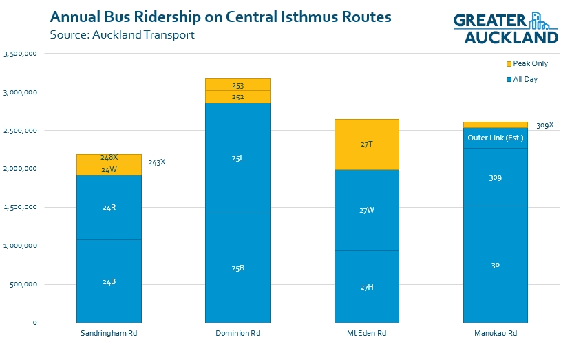
Dominion Rd buses are by far the most used with close to 3.2 million trips annually on them compared to 2.6 million on Mt Eden Rd and Manukau Rd with Sandringham Rd seeing 2.2 million. As a quick comparison, the NX1 buses have 4.9 million boardings and the NX2 buses have 2.9 million.
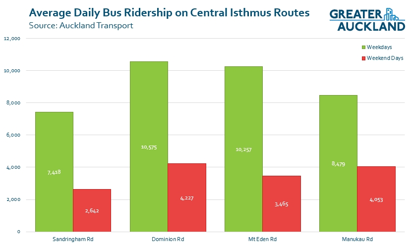
I’ve also broken the usage down by weekdays vs weekend days. Most notably here Manukau Rd has a higher proportion of use on weekends.
To put this in perspective, most light metro systems are built with an expectation of over 100,000 boardings per day with many lines carrying a few times that. Auckland’s entire current rail network sees about 76k per weekday and that should at least double once CRL opens. While we certainly would get more usage from connecting a route to the airport, we’re probably talking about needing a ten-fold increase in usage.
Zoning
While current bus usage can give us an indication of current levels of usage, enabling more development along the route will encourage greater usage in the future. The map below shows the zoning currently enabled in the Unitary Plan. In my view if we’re investing the kind of money likely to be needed, we should also be having a conversation about additional up-zoning but short of that, this is what we could get. First, a quick description of what the key zones allow for, although there are a bunch of other factors which can increase or decrease this. More detailed information on the zones can be found here.

I’ve added a couple of locations where we’d want stations (black circle) but there are a few other locations they could be useful.

From this we get
- Sandringham Rd – Much of the route is surrounded with THAB zoning, particularly around Balmoral Rd and at the Southern end at Stoddard Rd meaning there’s a lot of potential development allowed. What’s more, much of that THAB at the southern end is already owned by the government and can be developed by Kāinga Ora. (see map below from some of the previous work on light rail).
- Dominion Rd – Most of the route outside of the town centres is lined by Mixed Use zoning which allows for a lot of development but in most places, just back from Dominion Rd is locked in single house zoning with heritage overlays so doesn’t provide as much as Sandringham Rd does. The government does own a number of sites towards the Mt Roskill end of the route.
- Mt Eden Rd – This is probably the worst of the four routes with the only significant new development allowed at the southern end of the route around Three Kings.
- Manukau Rd – Like Dominion Rd, Manukau Rd allows for Mixed Use for much of the corridor (from Newmarket to Greenwoods Corner) but also has some decent chunks of THAB around Greenlane West and a lot around Royal Oak. The town centre zoning in Royal Oak also has a higher than normal allowing for up to eight-storeys. This probably puts it on par with Sandringham Rd for potential but it doesn’t have as much government owned land.
Other considerations
There will be many other things we should consider but one of the most important of those will be how it interacts with the rest of the network. For example, with the Sandringham Rd route, a station at Kingsland would provide the fastest option for those transfering from the Western Line – but there are better ways to deal with that.
The routes
The routes are kind of shown above but one difference is how they might connect to the city. In the case of Mt Eden and Manukau roads I’ve looked at running it under Wellesley St to take advantage of ‘the cross’ station that the Aotea station is designed to enable. This could also allow for a university station and for the Manukau Rd route, a station close to the Hospital. It could also see the route extended to, or end at, Wynyard Quarter before heading to the shore in the future. Because of the tricky grades through here, for Manukau Rd, it is less direct through Grafton Gully so crosses under the motorway higher up the valley.
For each of these routes we get the following distances from around Aotea to Onehunga and then the airport.
- Sandringham Rd – 12.9km / 22.4km
- Dominion Rd – 11.5km / 21km
- Mt Eden Rd – 11.2km / 20.8km
- Manukau Rd – 9.7km / 19.3km
Given tunnelling and underground stations are incredibly expensive, the Manukau Rd route being at least 1.5km shorter would save a considerable amount of money.
I’ve then run these routes through my travel speed calculator, which I’ve calibrated to match what Vancouver’s Skytrain achieves. This gives us the following travel times to the airport from the centre of the city (Aotea) with the routes taking 11 minutes from Onehunga to the airport.
- Sandringham Rd – 29 minutes
- Dominion Rd – 27 minutes
- Mt Eden Rd – 28 minutes
- Manukau Rd – 24 minutes
So because it’s a shorter, more direct route Manukau Rd almost three minutes faster to the airport than the alternatives and would be even faster than a non-stop heavy rail train, even if it was practical to build a line from Puhinui (which it’s not). As a good rule of thumb, each additional station would add about 1 minute of travel time so we could even include a couple more, such as at Greenwoods Corner and between Greenlane West and Newmarket, and it would still be faster while supporting a lot more development along the line.
Conclusions
Sandringham Rd
Sandringham Rd has some good potential but is the longest route and effectively duplicates the Western Line and CRL for a substantial distance, which seems pointless. My guess is that post CRL we’ll see large numbers of Sandringham Rd bus uses transfer at Kingsland for a faster trip so most of the benefits from using Sandringham Rd could probably be achieved from ensuring the bus lanes along the route were improved, the services streamlined (the timetables/operating patterns are messy compared to the other routes) and that transfers are made easy at Kingsland.
I also think our crosstown light rail proposal could really help in also serving that significant potential development near Stoddard Rd and even with an extra transfer, would be faster for people from the west to get to the airport than transferring at Kingland.
Dominion Rd
While it doesn’t look like a lot, all of the mixed use lining Dominion Rd means there’s lots of potential growth there, just not as much as some of the other routes. In saying that, it probably doesn’t have enough development allowed to justify light metro but with a few extra stations it still looks ideal for a surface level light rail route that would also further enhance the local town centres.
Mt Eden Rd
It’s hard to see Mt Eden stacking up due to the lack of sufficient development allowed around it. Like Sandringham Rd, it could do with a lot better bus lanes to improve the existing route though.
Manukau Rd
If we’re going to build light metro it should probably be along Manukau Rd. It’s not only the shortest and fastest but also probably enables the most development. It’s a route that with a future extension to the North Shore would see it link up three hospitals (North Shore, Auckland, Greenlane) and six university campuses (Albany,Akoranga, AUT & UoA in the City, Grafton & Newmarket). The downside is it is similar to the heavy rail network between the city and Newmarket and of course the cost of 10km+ of tunnelling wouldn’t come cheap. To me this is still the 2040+ option for after we’ve got our current rapid transit expansion priorities (including Dominion Rd) completed.
As to why not just do that route with surface level light rail, while it is more direct, it would actually spend a longer time on surface roads than Dominion Rd so a surface version wouldn’t be as fast.
If we were to build all of the above it could give us an RTN network on the Isthmus of something like this (with an assumed North-west too).


 Processing...
This could be a good long term network, but seems like what Auckland might need in 30 years time rather than now.
How possible is it to build Dominion Road, northwest and North Shore as light rail that link to Queen St…. and then in the longer term do the tunneling as demand overwhelms Queen St?
How, in two years did the government go from the Prime Ministers promise of Wynyard to Mt Roskill by light rail by 2021 to public transport courtesy of Star Trek sometime deep into the 21st century?
It’s really hard to either not laugh at the disarray of the decision making or be deeply cynical at any fantasy (policy) this government trots out!
Perhaps 108 filthy 8-10 litre diesel engines in varying degrees of tune running down Symonds St alone plus a thousand private motor vehicles looking for a better alternative is what “climate change is our generations nuclear free moment” was really all about.
How? Well that is easy. Some idiot at AT thought linking LR to the airport would be a great way to get people on side with the Dominion Road LR project. Instead people liked the airport connection idea and couldn’t give a damn about the dominion road part. Contrary to what might be written on this blog the justification was always about passengers and not primarily about airport workers, even connecting the poorly served residential areas was secondary.
The truly funny part is the AT strategy failed dismally. The connection to the airport focused attention on the shortcomings of the Dominion Road route. Like the previous LR scheme in the 1990’s the only answer now is do nothing for 15 years until people forget about the whole debacle.
The AT scheme didn’t have an airport connection. It had three branches coming out of the CBD.
What has bjorked the Dominion Road route is the Council and Panuku playing silly buggers over what can be built along it. It should be a slam dunk but I worry we’re locked into what we’ve got for another decade, and it’s holding up the rollout of a decent network to the Northwest and North Shore as a result
The first AT scheme in January 2015 had four branches but by August 2015 AT was already adding the airport on. It was an own goal.
https://www.greaterauckland.org.nz/2018/12/06/a-brief-history-of-the-light-rail-project/
Good post Matt. But I would go further and say even if the answer is light rail then it should probably go along Manukau Road as it joins more centres as well as the Hospital and Universities while still having space for development.
I would agree if it weren’t for that inner section with the hospitals and campuses. The section from the top of great south road to the middle of the city is very constrained, overloaded and has a number of awkward right angle turns as it wiggles through.
There is no way you could add LR and keep the already major bus corridor running well. No point in adding one big LR line if it means taking out a dozen other busy bus routes to do so.
The beauty of the dominion road to queen street route is that the only routes affected are the dominion road buses and the red link, which are directly replaced by the LR anyway.
Would it be possible for Dom rd light rail (which we need now) and Manukau rd light metro (which may be an awesome future option) to use the same tracks? Cause light metro seems like it would be awesome for the northern busway but we would probably want to convert that to light rail long before light metro is needed. Having the shore line connected to the old Dom rd lr and then connecting it to the new Manukau rd LM would presumably save a lot of money
It would certainly be possible to start with LR on the North Shore then replace it with LM in the future as long as the new system had the same gauge and similar weight.
It would be more difficult for driverless LM and driver LR to share the same tracks. The logical long term solution would be for LR to terminate in the CBD and people to transfer to LM to get to the North Shore.
I was thinking that LR would run on the shore until LM is ready and then it would replace LR on the shore.
If rapid transit to the airport was the be all end all then why reinvent the wheel at massive expense?
Why not spend up at Puhinui and design the rail junction with over passes to direct link that branch to the airport and run trains direct from Britomart, at the same time putting in those 3rd and 4th mains through to Southdown.
The Light metro is brilliant for a city that has light rail already but for the likes of Auckland, still in the PT dark ages its madness.
It isn’t always easy to identify, but I assume this is sarcasm?
No, I’m serious. As I said if the new objective is to speed up public transport to the airport by building light metro then there are more simple quicker and cheaper ways of doing it by adding to existing infrastructure than going through a PPP with a Canadian Superannuation investment fund that fleeces he public of Auckland whilst pocketing profits for themselves.
Having said that I don’t believe transit time to the airport should be the objective rather far better improvement of PT on key existing routes.
Agree with you on the Superfund.
And it’s an RTN through SW Auckland, currently a PT desert.
Puhinui is a completely different solution for a completely different issue. If Puhinui is ever put forward as an alternative to LRT through the Isthmus, its clear there is a misunderstanding on what is being proposed.
Perhaps the best idea is to determine the entire LR design (or at least significant amount) like in your last one, then the government commit to a “20” year plan of x km per year?
Would allow for better ability for all in terms of planning.
Would also allow for routes like the Manukau one (if not done first) to be on land well in advance to protect the route.
All this seems to make ever more uncertain as to why the NW line is not further ahead.
One problem I foresee with that is our electoral cycle runs 3 years and the philosophy of PT depends on what government you have. It would be all too easy for advocates of motorways to easily handicap such a development and have every excuse under the sun as to why the proposed additions to the system be abandoned.
Which is exactly why this whole project should have stayed at Auckland Transport. I think Auckland Council and its CCOs aren’t as affected by elections as they pay more attention to previous masterplans and reports instead of politics. Twyford giving it to the NZTA people in Wellington killed light rail’s chances.
I agree that this is one of those occasions where the CCO’s being at arm’s length would have been a good thing.
I think AT is not actually much more independent than the NZTA. However, local council isn’t whipped in NZ. So changing a couple of members doesn’t lead to a massive shift.
If National had one 5% more of the parliament’s seats they’d have a majority and transport policy would be radically different. You could change Chris Darby for Cameron Brewer (5% of seats) and make very little impact on council/AT’s transport policy.
Excellent data analysis, Matt. Thanks.
“we’re probably talking about needing a ten-fold increase in usage.”
Obviously this is huge. But let’s think it through. If growth was to happen on one of these corridors, rather than on the outskirts, we’d be taking a big step towards a compact city.
The thing is, what else would be required to support that growth?
Ten times as many schools? Will the MoE buy that land?
Ten times as much water and sewerage infrastructure? I assume this means separation of stormwater PLUS the central interceptor PLUS expansion PLUS treatment of the stormwater.
Ten times as many small plazas and parklets?
Ten times as many street trees? (I had to add that!)
And of course full cycling infrastructure and wider more walkable footpaths.
What about power?
I’m not opposed to the idea, but all of this will take 20 years to sort anyway even if things went well (and golly we’d need some agreement from the population). So racing ahead with the transport infrastructure without doing all the other infrastructure work doesn’t seem wise.
Mind you, neither does piddling along with greenfields due to inertia…
Surely if Airport to wherever has become the objective, then both wherever, and station locations between, need to be established by load modeling and surveys.
As both my employment and residence were located in the immediate CBD fringe, and as a regular air holiday traveller, and formerly regular business traveller, I have been in a lot of taxis, shuttles, and airport busses. on the corridor between the CBD and the Airport.
For outbound business travellers relatively few live in the CBD, so CBD to Airport travel options are largely irrelevant.
The same can be said of outbound recreational travellers and upon their return.
Business travel is usually very time sensitive, get as much done in a day as possible and scurry home for the night to avoid overnighting expenses. The fare is picked up by the employer. For inbound business travellers most work destinations are not in the CBD. The CBD just has the greatest concentration of such destinations. Even in the CBD, there is a distance between the office and the public transport pick up , drop off point. So Taxis prevail, even more so if a group are travelling together. A CBD to Airport public transport freed from general traffic congestion could however be more attractive at peak times because of increased journey time reliability. Inbound holiday travellers usually have their full airline luggage allowance. If staying with friends and relations then it is unlikely that their Auckland destination is the CBD anyway. The door to door shuttle service is convenient with luggage and cost effective when travelling together to the same destination.
The cost sensitive, intrepid solo travellers do provide a market for public transport options. The existing Sky bus patronage suggests that this market between the Airport and the CBD is not huge, certainly far far short of that required to justify perhaps the most expensive transport project ever proposed for NZ.
Let us get on with a solution to CBD ultimate bus capacity issues now, and see how the Puhanui interchange works out before spending a massive amount of money providing something like Stephen Joyce’s RONS that the builders want to build rather then lots of smaller, but collectively more important transport improvements needed first.
Added to the above. It is clear that continuing growth in air travel patronage is already environmentally unsustainable, and increasingly socially unsustainable, and eventually likely to become politically unsustainable. So demand modelling of transport requirements to and from the airport may well become overstated.
Has the airport yet again become the deciding factor purely because politicians are frequent flyers?
Even if they are frequent flyers, it is a massive step for them to become even regular airport to city public transport users. Can’t see it happening.
James Shaw is a frequent flyer. So much for the so-called ‘climate emergency’.
However, the airport is not just about flyers, it’s also about a rapidly expanding industrial area.
no where has it been shown that journey time to the airport is the most important outcome (or even an outcome at all) for the LR proposals – its pure speculation at this stage and based on the leaks of the old material from last year. the outcomes MoT want for the LR proposals have not been made public yet.
Amazing what happens in a vacuum of information. More adherence to the “transparent decision-making” aspects of the GPS might have prevented speculation based on leaks, I guess.
SDW
What exactly is the MOT being tasked to do?
If they are primarily being tasked to identify and quantify public transport problems in the CBD and central isthmus area, as a first stage, and then perhaps onward extensions that could be leveraged of any upgrades adopted for this area I would have no problem.
What I fear is that they have embarked upon finding an application for one of two competing light rail proposals to fix with only scant regard to first adequately defining the problem intended to be mitigated and the desired outcomes of any chosen solution.
Hopefully I am wrong.
Yes, good comments, Don. The GPS on Transport is clear that we should be expecting transparent decision-making and value-for-money over the whole lifetime of the project, and that all benefits and costs should be considered, as well as the need to be flexible as times change.
NOT a silly focus on a subset of particular benefits such as travel times to the airport.
Value for money in GPS 2018:
– increases the emphasis on value for money to maximise the impact of money spent to achieve the Government’s outcomes
– indicates that decision-makers should take into account the full range of benefits and costs over the whole life of investments, and be cognisant
of possible future changes and uncertainty, so that investment is made in options that perform best across a wide range of different scenarios
– places greater emphasis on transparent investment decision-making and on enhanced reporting on the outcomes achieved by investment.
How different is light metro to our version of heavy rail which is not that heavy anyway. For instance could the light metro run in the CRL. If it could that could wipe a couple of billion dollars off the project. It seems to me that the light metro could branch off somewhere on the southern line and then proceed down Manukau road. Obviously it won’t be automated well at least not in the CRL. I am assuming light metro uses DC voltage overhead or maybe third rail. That poses a problem. We could still build the light rail up Queen Street and eventually to Mount Roskill this should have started years ago. Recently I was in Konya in central Turkey. I was astonished to find they had a light rail system running through their main street. Very nice interestingly there were no overheads in the main street for a distance of about 3 kilometres. They must use batteries on this section. Maybe if the light Metro only ever ran down hill in the CRL we could get away with batteries however they would still have to negotiate their way up to Newmarket. “Out of it I know.”
Why would you put it in the CRL? All of the CRL slots will be taken up by the existing lines.
Well I knew you would say that but why not at least it won’t burden the CDB with another dose of construction disruption plus save a couple of billion dollars. As for the CRL being full up I will believe that when I see it unless you are thinking about running a large number of near empty trains through it. And it hasn’t even being built yet so we only have the faith of a number of Evangelical supporters that it will be a rip snorting success. And why don’t you try thinking outside the box a bit you might surpriseyourself. Maybe only one idea out of many will be any good but that idea could change the city and your life.
If the CRL is a dismal failure and despite all that is spent on it and we don’t need to increase frequencies from what they currently are then yes you are right there will be available slots.
However, if the countries’ biggest ever infrastructure project fails to significantly increase patronage on the rail network, then it would be next to impossible to build a case to spend any money on a light metro line.
Of course it wouldn’t have to go through the CRL it could just go to Newmarket or maybe Britormart. As long as its built to a sufficient standard that it can run on the national rail network for a small distance. That way we leave Queen Street clear so we can build the light rail to Mount Roskill and we get rid of the stupid idea of running light rail all the way to the airport. And we won’t have to double track the Onehunga branch.
I agree regarding keeping Queen Street free for surface light rail, it’s the worst place for an underground line anyway as it is in the bottom of a valley.
The best route for light metro through the CBD is exactly the yellow route drawn by Matt in the last picture above. I can’t see it sharing track with the existing rail network though so it should be built to whatever the best specification for its own operation is.
Oh of course if Matt.L says it should go there then that’s what should happen. But some times I like to make up my own mind.
The power on non wired sections is usually inductive
Looked up the Konya light rail apparently it was built in 1992 imagine if we had of started building light rail in 1992 we would probably be halfway to the airport by now. I had a careful good look and I couldn’t see how it was powered unless the inductive pads were buried under the concrete but I didn’t know what to look for anyway so assumed batteries. So maybe its is inductive given it was built in 1992.
The term “light rail” relates to the different (usually fewer) regulations, standards etc. that networks that don’t have to conform to mainline standards have.
It has nothing to do with any physical weight of the network nor the rolling stock that run on it. Theoretically: a light rail system could be physically heavier than the mainline and it’s rolling stock cold be heavier than passenger trains that run on mainline networks.
So no; light rail could not run down the CRL as it inherently wouldn’t meet mainline standards.
Thanks Matt for this analysis. In particular, you’ve highlighted the fundamental issue re the RTN – are we trying to build a real network, or are we trying to find the means to get to the airport as fast as possible? This issue seems completely lost on the proponents of heavy rail to the airport, and their deafness to this point makes me truly scratch my head – I can only assume that they have other, unstated, agendas. Quite apart from the ridiculous notion that being able to save two or three minutes of travel time will be make-or-break as far as airport patronage is concerned. Practically speaking, the effect of their argument is that a trip taking (say) 44 minutes will be brilliant and a huge success, while a trip taking (say) 47 minutes will be shunned by passengers and be a dismal failure. Really? As a regular air traveller those kinds of consideration are completely irrelevant to me when I arrive in a new city and, I suspect, to almost every other passenger. If time is really that critical for air travellers then they can do what they do now and take a cab, and be in the city in 30 minutes. It’s not like that option is going to disappear.
The problem with building a real network is that most of the corridors which we discuss here are very unlikely to get any kind of RTN for decades, but the need for an RTN network is now. What should we do in the interim?
In my view we should be concentrating less on mode and more on building a truly interconnected strategic (I hesitate to use the word “rapid” as this just provokes definitional arguments) first-level network. Now. In the interim this will be mostly bus with significant priority measures allowing something approaching “segregation” but with the ability to convert/upgrade to a faster/shinier/sexier mode in the near future. Only when we actually have a decent strategic network can we get on and promote PT as a viable alternative that allows you to ditch your car. So establishing that network, using seriously prioritised buses to me is the first and most urgent issue. Let’s work on a LR network or whatever to incrementally replace it in five, ten, fifteen years or however long it takes to move the politicians from their inertia. But right now, I need a network. A real network. Not in twenty years from now, but right now. And I’m picking that this would be the view of most PT users who experience the frustration of trying to navigate Auckland without using a car.
Yes. Absolutely.
But from what I’ve seen recently, AT are STILL stuck in 1970, thinking bus priority can be provided by making sure the traffic can flow.
Their engineers aren’t keeping up with basic transport concepts, such as traffic evaporation, low traffic neighbourhoods, the usefulness of bus gates and of the need to prioritise pedestrians (bus passengers) at intersections.
Yes to all of the above. None of that is hard – or even expensive when compared to the benefits of having a network. An ACTUAL network, not one that may or may not arrive in twenty years.
Heck my guess is the removal of on street parking and replacing it with bus lanes on key routes you could eliminate the need for a lot of transport spending.
Yes, that would be a brilliant quick fix which would greatly facilitate the strategic network.
To spend billions on a metro, the stations should be surrounded by zoning for large scale development, 30-50+ story apartment towers, etc.
There would be too many NIMBYs with lawyers within the Manukau Rd route, just think Orakei station.
From this point of view, Dominion Rd has better chances of being successful.
Greenlane racecourse is doing that right now.
If we took the Manukau route, then the Onehunga line could easily be switched to the cross town route.
What impact would that have on the planned HRT network after the CRL is complete? Remove the purple line?
I also note that Royal Oak Mall could easily become a TOD node. The 30 would be replaced by the light metro and the 66 would benefit from direct connection. The 66 then would feed from both East (Oranga and Penrose HRT) and West (Three Kings).
🙂 I’m imagining the pedestrian and cycling amenity improvements!
An underground TOD station would make a major difference to the
pedestrian (and cyclists if designed for them as well) connectivity at this roundabout.
Running the risk of keeping the streetscape unsafe, I suppose?
Removing the traffic via transit options would help alot.
If you also got Hillsbourgh Road feeding to this section of the network. Then Royal Oak or Onehunga would be a good transit junctions.
Yes, I think you’d replaced the purple line in CRL plans with this one and get better outcomes. Even to the likes of Ellerslie it would probably be faster.
And yes, Royal Oak would become a great location for a TOD which is one of the reasons I think the Manukau Rd route is better for a LM line than Dominion Rd is (which should have street level LR)
I think we’re getting carried away with projects that will cost gazillions of dollars and won’t be even considered seriously for 20-30 years. What I’m looking for is a plan that gets huge numbers of cars off the road now, so that we stand just a chance of our planet being habitable in the midterm future. We don’t have the luxury to prevaricate – we need a strategic network that can be promoted as such, and we need it now. Practically, the only way that’ll happen is with buses and bus priority measures. Sure, let’s get LR lines or whatever under way as well, but let’s not sit on our hands while we wait for someone to figure out how to fund it.
We need 83,000 per year cars to convert to convert EV or be mode shifted.
https://twitter.com/stateless/status/1184700157394214913
My opinion, the best way to do this is increase the walking/cycling budget by at least x5.
The NZTA allocation ($114million) in ATAP is allocated to NOMB, Seapath and Skypath.
Im still trying to dig into the AT allocation ($491m), but the reality is we need to increase the roll out from 5-9km to 100+ km per year.
An ebike can do 100km per 1KWh. An EV does 6 km per 1KWh.
Then if you factor the space vs roading and parking costs. eBikes are a major decarbonisation tool.
The 83,000 is just for Auckland.
Agree about the potential of e-bikes. I have clocked up nearly 6,000km in two years. Helped by having great off road cycletracks nearby. The wind now no longer affects me!
Yes, we need more walking and cycling money, for sure. But many of the trips that generate the most carbon dioxide are much longer than would be practical for many people, so it would be a mistake to think we could achieve what we need to just by funding walking and cycling.
And of course, all new buses to run a “strategic network” should be electric, from now on. If we want to shift away from fossil fuels then AT has to set the example by specifying electric now, not in several years’ time.
Is the rollout of more bus priority being delayed by the LRT fiasco? Attention being focused on covering @**es rather than getting on with the rest of the PT plans?
I agree that its the quick, low hanging fruit and that parking on major arterials and thoroughfares should be first to go.
Given that any congestion toll cordon coming for Auckland should bound the Isthmus then any rail alternative towards the Airport would cross the cordon.
This both strongly suggests the need to for rapid transit and future PnR sites.
Light rail just doesnt cut it and the only sensible solution is grade separation (either light metro or heavy rail extension) & that decision should be left up to a business case to sought out (taking into account as a sensitivity test the congestion tolling & PnR.)
Why does LRT not “cut it” but Light Metro might?
LRT “rapid” would be fine if grade separated
Which it will be, right?
Even on Dom Rd it will be separated from general traffic lanes and have priority at intersections
In many cities, light metro is just light rail on a fully grade separated right of way (tunnels, bridges etc). Often using exactly the same trains as we would get for street running Light Rail.
Two Points:
1) The Southdown-Avondale corridor is not available. This has been confirmed.
2) The NZ Infra proposal is at ground level, fully fenced, with a tunnel beneath Queen Street, and a mix of flyovers and underpasses across CMJ and various roads/town centres along the way.
1. as I understand it that’s not entirely correct as there would still be corridor available should it be needed. Not that Kiwirail need it as even if tracks are built for Northport, they’d be moving trains to a yard somewhere in the Northwest and only sending them through the city at night – at which point there’s no benefit to the corridor over just sending them via Newmarket.
2. And what source do you have for NZ Infra’s proposal? Also even if true, which I doubt, that would be an awful solution
Your graphs and charts are really fascinating, Matt. The far steadier ridership on the top graph for Dominion Rd during the day is noticeable. Surely that’s a really important input to the planning for the isthmus – unless future demands are likely to change these corridors relative to each other significantly.
Is that graph for a typical weekday or for 1/365th of the year?
And Manukau Rd looks pretty peaky on the top graph (although less so than Sandringham and Mt Eden) and has next to no peak-only services. But it is really well used on the weekend.
I’d love to hear people’s guess for the reasons behind these differences.
The data I have shows how many boardings there are on each route for every day so I added up all the weekday boardings and divided that by the number of weekdays and did the same with weekends.
I think the fact Dominion Rd has strong all day usage is also reflected in the first graph showing buses by hour of arrival in the city. Dominion has many more services which will be both to serve demand but also some of that demand probably exists because of it.
One thing that’s interesting to note is how those peak only services are used differs by route. For example on Sandringham Rd the 24B and R both see a lot of extra services added as well as some on the 24W so extra peak only ridership occurs on the regular service pattern. But on Mt Eden Rd the all day services stay the same through the peak (3 per hour each) and all the extra peak buses are on the 27T. So perhaps it’s not as clear-cut as it appears on the graph.
Matt, could it be you’re warming to the idea of a light metro?
It’s not a case of warming to it, I’ve always liked it as a mode and we’ve talked about it before. It’s just I don’t think it’s the best value for money for us right now when we also desperately need so much RTN expansion. Likely a case of us being able to get 2-3 light rail lines for the cost of one light metro lines.
Edit: I should add that while I don’t think it’s the priority, if we’re going to do it, we should at least do it in the right place
Matt L
Yes, great analysis.
I wonder about your timing though: “each additional station would add about 1 minute of travel time”
One thing that impressed me was the speed of exit and entry for the (relatively) new light metro to Bignami in Milan. Dwell time seemed negligible with the easy ingress and egress. I acknowledge that on that line you don’t have passengers with bags, but you also don’t have narrow aisles and stairs to negotiate.
It assumes a 30 second dwell time, although I’ve been on systems that can do that in 25 seconds. The other 30 seconds is the time from slowing down and then accelerating back up to speed again.
The CBD to Airport obsession is the transport version of cultural cringe.
Trying to blindly emulate London/Sydney/Hong Kong without understanding the idiosyncrasies.
You need to learn how to walk before trying to run. Get London or Hong Kong’s bus network first, then their rapid rail, then think about luxuries like airport rail.
Sorry should say Auckland is already doing very good things with buses, now needs step two.
We need a completely separate discussion of/for airport access. Mixing the two has muddied the waters something awful.
None of the Light Rail Tram networks are in anyway close to the patronage of the Light Metros e.g. Sydney Metro has gone from 20k per day as commuter rail to 77k (after 6 months) and is expected to hit 100k per day in the first year (the Canada Line has 147k per day). You also need to ask yourself: If you could build three tram networks for the cost of one Light Metro could any of them achieve 1/3 of the patronage of the light Metro networks? Stage 2 of the Sydney Light Metro will see daily riders jump to 250k and that is more than Melbourne’s entire 25 route 250km Tram network and 206m daily riders. Melbourne Trams has 2,200 staff including 1,200 drivers – Sydney Metro has no drivers.
The fact that you’ve chosen Melbourne trams as a comparison diminishes the strength of your argument somewhat. Melbourne’s system has lots of mixed traffic running with relatively small vehicles, unlike modern light rail systems including that previously proposed for Auckland.
GK. I also looked at Sydney Light Rail, Gold Coast Light Rail, Adelaide Light Rail, Newcastle Light Rail (more of a tourist rail) and Canberra Light Rail. I have run out of new build Australian light rail systems and none of these will exceed one of Auckland’s commuter lines post-CRL (except Onehunga). My point still stands.
You missed the part where Sydney’s metro northwest cost AUD $490m per km.
Apply that to aucklands Mangere route and you get $11b dollars. Add in the northwest route at another $16b and the two line network would cost $27b dollars.
The same with light rail was costed at $6b, same lines, same stations.
The metro would cost four and a half times as much as light rail for effectively the same thing. Can we afford it? No. Would we get better patronage from a network four and a half times the length and four and a half times the number of new stations for our money, of course!
One thing this does show is maybe the Manukau Road route is better for stage one LRT.
Especially if it is combined with integrated network planning around Royal Oak with a bus priority network feeding from Three Kings/Hillsborough thru to Penrose.
Then also acts as an anchor for a cross town New Lynn to AMETI/Panmure. And A2B extending the BRT network thru from Mangere/Onehunga.
Sydney’s metro isn’t a light metro.
Patronage is rarely a function of ultimate capacity.
Patronage is primarily determined by walk up catchment population density, the effectivenes of connecting services, and also service levels.
Undoubtably the service levels of a LM service will be better then LR but it would many years before this difference in service level would have any influence on walk up catchment density.
I’ve quoted patronage not capacity. Actual capacity is targeted at 40,000 per hour and if they go from 20k patrons per day to 100k patrons per day in the first year it is not catchment density as it is time capacity (speed is not what you are factoring in) this is twice as fast as the fastest Tram service in Australia.
One of the big justifications I kept getting offered for building light rail to the airport (instead of extending the Onehunga branch) on this blog in the past was that it (allegedly) would cost a lot less.
I think most people of even average intelligence can appreciate that If you put the light rail in its own dedicated & isolated/grade-separated corridor (much of which would need to be either subterranean tunnels with subterranean stations or elevated viaducts with elevated stations) for metro-like operation; that’s going to greatly increase the costs.
And far beyond what simply extending the Onehunga line would be.
And I recall that many of the frequenters of this blog were anti-tunnel, on the basis of (alleged) expensive maintenance. Or is that for only when that tunnel is replacing the Auckland Harbour bridge?
Did you read the opening paragraphs of the post?
The rest of the post and the comments need to be read in light of that logic.
Oh I’ve heard this Matt Lowry saying for years how “its not all about the airport” and trying to say that Dominion road needs to become rail.
Of course, the Auckland Council’s highly dubious commissioned report was all about… …a rail connection to the airport (and Mangere).
And the pros and cons of different modes are discussed in the post linked to in the intro. This post is about “if fast light metro is the answer…”
It doesn’t mean that the author’s (or any other contributor’s) views on the pros, cons and best solution for Auckland’s transport needs have changed.
Extending Onehunga still has the issue of adding little capacity to the overall network, but this has been explained repeatedly so there is no need to go over it again in a post specifically about route options for Light Metro.
This is a point that is repeated over and over. HRT in Mangere is adding demand to a network with capacity for new supply.
Why do the HRT proponents keep ignoring this issue?
Of course I meant “without capacity”
“Why do the HRT proponents keep ignoring this issue?”
Because we know it’s a fabricated red herring.
Fabricated why?
Why do you think?
Because they’ve decided that they support the light rail and will now come out with anything to justify it rather than entertain that they could be wrong.
Why do people usually fabricate things?
I mean anyone with common sense can see that the ono LRT-option would merely be an extension on an existing branch anyway and that post CRL, the two-track tunnel will be shared by what will essentially be 2 lines. It will be ample capacity for decades to come.
Right. So “wave your hands” and you are right?
Give us some analytical answers and we’ll take you seriously.
Hey at least I’m the one who’s given some explanation so far.
Where’s your “analysis” again? Oh I know, accusations of “wave hands” only applies to people you don’t agree with this never to you…
This has been argued over in several other threads (one if them linked to in the introduction), and again, there is no need to re-hash it in a post specifically about route options for Light Metro.
That is still the case that surface light rail using Dominion Road is still the cheapest option for providing rapid transit on the corridor between Onehunga and the airport.
The option described here of elevated light metro is definitely not the cheapest and I don’t think anyone has claimed that.
Sydney’s metro isn’t a “light metro”.
It’s a regular metro. It’s just that some of it is on a raised viaduct.
Interesting post I hadn’t commented on unusually , so putting this here now to get any new comments.
I’m a fan of a Manukau Rd line of light rail or light metro, seems a good fit.