One thing the light-rail debate over the past couple of weeks has re-emphasised is there remains a lot of confusion about the different modes that can be used for rapid transit and also how we should make decisions about what mode to use for specific routes. Firstly, I think it’s important to put these discussions in the Auckland context and rapid transit is described in the 2018 ATAP as:
Rapid transit forms the backbone of Auckland’s public transport network, providing fast, frequent, high capacity services along corridors that are separated from general traffic and therefore unaffected by road congestion.
When thinking about the different modes there’s always plenty of debate to be had over different terminologies but there are generally four types of system we are discussing:
- Bus rapid transit – like the Northern Busway. I also classify trackless trams as one form of bus rapid transit as essentially they are just “big buses”.
- Light rail – like what was originally proposed for the City Centre to Mangere corridor, what’s being built in Sydney and what has been built in Seattle in recent years.
- Light-metro, like Vancouver’s SkyTrain – with modern versions usually being driverless. Wikipedia sometimes calls these “Medium capacity rail systems“.
- Heavy rail, which can be either a system fully dedicated to passengers like the New York Subway, or run on tracks that are shared with freight services like Auckland’s current rail system.
Each of those scale in terms of capacity, complexity and cost with the key differentiators being the size/type of vehicle and the extent of the priority they have.
For quite some time now, Auckland has had a broadly agreed “rapid transit network” This was outlined in the 2016 Auckland Transport Alignment Project – although at the time it was called the “Strategic Public Transport Network”. This network of different corridors shows where high quality, high capacity public transport is required to make Auckland work successfully over the next few decades. There are no big surprises here – essentially the map links up all the major centres of Auckland and ensure that most major parts of the city have some proximity to rapid transit (accessing by walking, cycling or feeder bus).
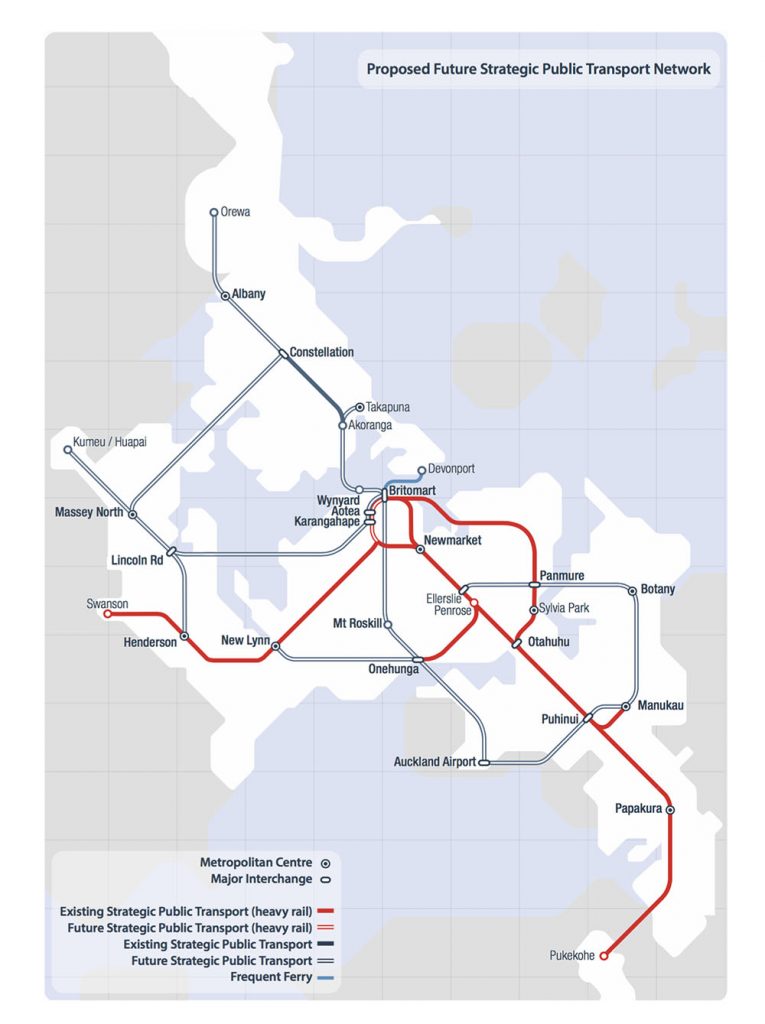
Aside from the rail network (and the Devonport Ferry) this map didn’t specify mode for the other corridors (although one could assume that they were generally thought of as “not heavy rail”). ATAP also set some direction about how mode decisions should be made through future work:
Mode choice for strategic network improvements should be driven by capacity requirements to meet forecast demand, integration with the wider network and achieving value for money.
These three factors – demand, network integration and value for money – provide some useful guidance for how sensible mode choice decisions should be made.
The 2018 version of ATAP was pretty similar to this network, although it did provide some guidance about “likely future mode” of the different corridors – matching the proposals in our own Congestion Free Network to use light-rail for the North Shore and Northwest corridors:
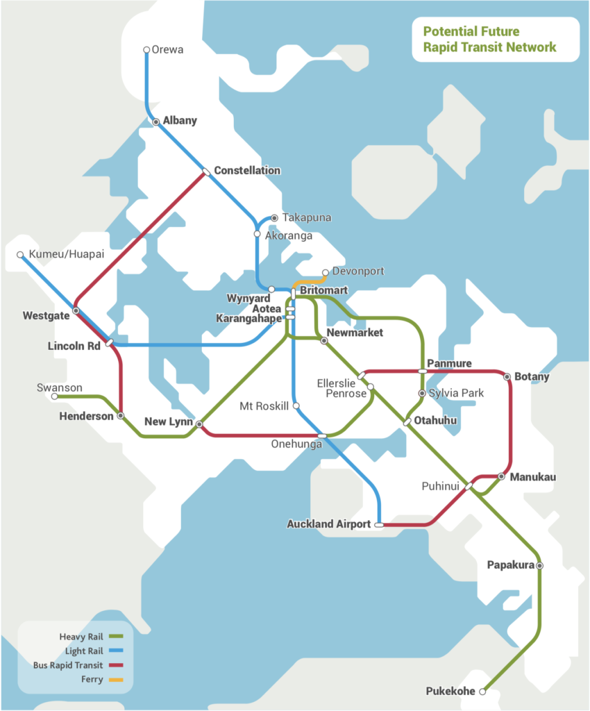
There’s a bit of discussion in the ATAP document around the preference for light-rail for the Northwest and North Shore corridors – mainly focusing on the point that light-rail provides a higher level of capacity than bus and therefore better meets future demand. It’s also noteworthy that rail of some form or another is proposed for all the corridors feeding into the city centre – with bus rapid transit focusing on “cross town” routes. This is most likely due to the higher demand on these ‘radial corridors’ and the lack of space in the city centre for terminating large numbers of buses.
What the map above illustrates is that a rapid transit network can be made up of a number of different modes, because the characteristics of the corridors are all pretty different from each other. For example, the demand from Akoranga and the City Centre is going to be much higher than say the New Lynn to Onehunga line. Put simply, many more people want and need to travel on some of these corridors than others.
Another important difference between the corridors is about space and level of priority – how easy or difficult it is to add a dedicated high capacity public transport corridor. The distinction here comes between the modes that can run ‘on street’ – like light-rail or bus rapid transit – and those that cannot, such as light-metro and heavy rail. Modes that are able to run on street allow for a corridor to be delivered at surface level where it would otherwise be very difficult/expensive to provide for e.g. the Northern Busway buses use the motorway and local roads when outside of the dedicated busway. This can be especially useful for stageability as if you go for the fully ‘off-street’ modes then the corridor needs to be either:
- At surface level in their own corridor (expensive and next to a motorway or cutting a swathe through an area by demolishing houses).
- Elevated (very expensive, ugly and possibly un-consentable in some areas)
- Underground (extremely expensive)
You’ll notice that many of the future rapid transit corridors are next to motorways but others, such as Dominion Rd, aren’t.
Pulling together some of the key factors, each mode has its strengths and weaknesses. I’ve elaborated on this in the table below:
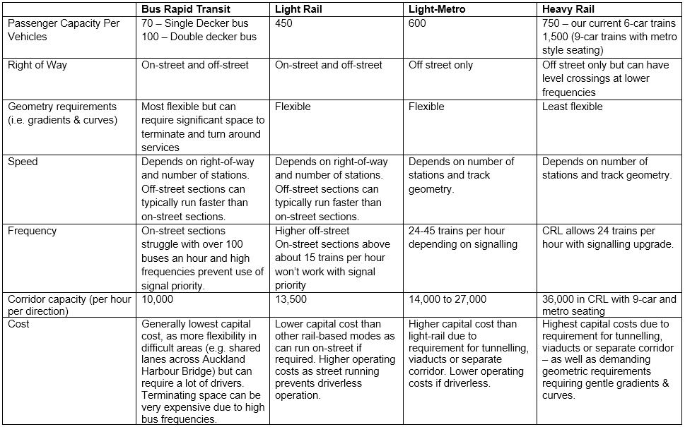
Generally cost increases as you move from left to right, but you are also able to carry more people more efficiently as well. Importantly, speed of the corridor doesn’t really depend on mode, instead depending on the right-of-way and how many stations there are. Some of the most important distinctions are:
- Because light-rail can carry more than four times as many people per vehicle as bus rapid transit, you need at least four times as many buses (and drivers) to meet a certain level of demand as you’ll need light-rail vehicles. At low levels of demand this is fine, but as demand grows it can become increasingly difficult to maintain an efficient bus system – especially where all these buses end up terminating or picking up and dropping off large numbers of passengers.
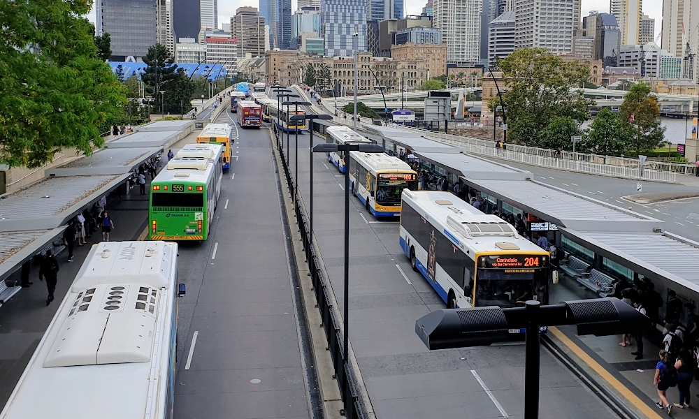
Brisbane’s South Eastern Busway has buses tripping over themselves
- Because light-metro cannot run on street, it requires much more expensive infrastructure than light-rail if there is no existing corridor to run on. Vancouver’s early Skytrain lines used an old railway tunnel through downtown but outside of that is generally built on high viaducts (hence the name). Later lines have required extensive tunnelling that was costly and disruptive, as well as having short station platforms that will be extremely difficult to extend. Driverless operation does mean that these systems usually run very cost-effectively, which over time will offset the highest construction costs to some extent.
- Because heavy rail has much more demanding geometry than light-metro – a very low tolerance for sharp curves or steep gradients – it has the highest construction costs of all. But heavy rail also provides the highest amount of corridor capacity as very very large trains can be run. The Yamanote Line in Tokyo – for example – carries over 4 million journeys a day on trains that are 11 cars long and come every 2 minutes.
Putting all this together we can pull out some pretty basic questions that help point towards the right mode:
- Can the corridor easily accommodate an “off street” mode, or do sections of it require challenging tunnelling or elevated sections?
- Is demand high enough that bus rapid transit would not work effectively (without massive infrastructure like underground city centre stations)?
- Is demand high enough that surface level light-rail would struggle to operate effectively, and tunnelling or elevated infrastructure is justified?
- Is demand high enough to require heavy rail and justify its cost?
So let’s apply this approach to the City Centre to Mangere corridor and see where we get.
- The southern part of the corridor, between Mt Roskill and the Airport, can accommodate an ‘off street mode’ next to the motorway. There are some tricky sections, like getting through Onehunga, over the Mangere inlet and accessing the Airport, but generally an off-street mode is feasible in this section. The northern part of the corridor is a different story, with no available space between Mt Roskill and the city centre to ‘easily’ accommodate an off-street mode.
- The demand seems like it’s high enough for bus rapid transit to not work effectively, especially at the city centre end of the route. A few years back NZTA explored this option in detail before eventually agreeing with Auckland Transport that light-rail was a better long-term solution.
- It seems unlikely that demand is high enough for surface level light-rail to struggle, and therefore conversely for major tunnelling or elevated infrastructure to be justified. Light-rail can carry up to 500 people per vehicle and can run at frequencies of one vehicle every 2-2.5 minutes. This means around 10,000-13,000 people per hour can be carried – substantially higher than any existing rapid transit corridor in Auckland. Furthermore, while Dominion Road is one of Auckland’s busiest bus routes, it still carries far fewer people than the Northern busway or the main railway lines.
- In the long-run, especially if the ATAP rapid transit network map becomes a reality and all three light-rail lines plug into Queen Street, then it’s feasible to see light-rail no longer working and there might be a need for a different mode. But that feels like a 2050 issue that can be solved in a while variety of ways (more light-rail corridors through the city or keeping more North Shore bus services using the Harbour Bridge like we propose in the Congestion Free Network).
Many media articles over the past couple of weeks highlight that the Super Fund proposal seems like a ‘light metro’ option. This means that it will need to be tunnelled or elevated between Mt Roskill and the city, with some reports suggesting they’re looking at an elevated track above Dominion Road and then a tunnel under Queen Street. Given it’s pretty impossible to see elevated rail down the middle of a main street being consented, this probably means the whole Mt Roskill to city section would need to be tunnelled – which is over 7 kilometres! It seems unlikely demand will be high enough for this to be justified, even if the operating costs are reduced by having driverless trains.
Therefore, we come back to light-rail being the most sensible mode for the corridor. As has been pretty clear for many years now.

 Processing...
You forgot the row at the bottom of the table headed BusSnake, Manbearpig and other novelty impacts on the CBD.
Also missing is the row: “How readily can aging traffic engineer dismiss operational constraints and poor user outcomes by hand waving dressed in cynicism dressed in humour?”
hahaha
Boomer Humour, there’s nothing quite like it
Nick I honestly think this is one funniest things I have ever seen in transport. An overly aggressive boss at AT decides he wants a big legacy project. He he casts around for justification for it and someone says “well it would replace a lot of buses”. Then he surprises the Mayor with it. Looking for more justification someone suggests running it to the airport. Problem is they already think heavy rail could do that job with space for 450 people and their bags, and light rail only carries 210 with most of the seats gone so some spark says “why dont we say we can link two units together for 420 people”. Boss says “call it 450, nobody will notice”. Aggressive boss leaves and so they convince incoming government to take it on. Naive minister says “hell yes, but will people really crowd into two light rail units kitted out for short running and go all the way to the airport with their bags?” Superfund managers see a chance to get a good return (at least to their fund ) at no risk to themselves. New plan “we will go under, over and through everything but you can’t see our pictures!” “Shit who gave them our pictures?”
You know that Trey Parker and Matt Stone have apologised to Al Gore for “Manbearpig” because it turns out he was right all along, right?
He was right, but he is still a boring old arsehole who lifted himself from an obscure position by flying around the globe telling others they needed to go without carbon. By the way Daphne I am not a boomer. You should be able to see that by my extreme cynicism and depressive manner.
Good article. I guess the good news from this is that the government will have a no brainer decision next year to push ahead with NZTA’s option. Which seems like a good result, given how dodgy CDPQ is.
Just a pity 18 months have been needlessly wasted.
I wouldn’t be so sure. Much of what we’ve been reading about light rail is part of an organised campaign by road lobby and National party aligned right wingers in the MOT and NZTA. Put simply, they’ve knifed Twyford (whose has shown an unbelievably level of political stupidity – does anyone think Winston Peters would have allowed himself to be so comprehensively stuffed by leaks?) in what is an existential struggle for the future of transport.
Given the level of ambient and active institutional resistance to light rail in politically appointed circles in Wellington it isn’t a given that right option will be chosen. It isn’t beyond the people behind wrecking Twyford as minister to deliberately select the wrong option then sdit back and obstruct it until an incoming National government cancels it completely.
NZTA officials will just sit back and do nothing. They can wait out Twyford, Ardern and co.
NZTA seems to have a lot of dirt that needs to swept under the carpet.
https://www.lawfuel.com/blog/transport-agencys-lawyer-problem/
Isn’t that a shocker!
Both NZTA and AT, stacked with National party people, have been obstructive and opaque for many years. For a time they had offices in the same building
Phil Twyford 19 Sept announced the appointment of five new members to the NZ Transport Agency Board.
The new Chair Sir Brian Roche will deliver the Government’s transformative agenda along with a stronger regulatory focus.
“Our Government has rebalanced transport spending to tackle the long term issues of boosting regional economic growth, reducing greenhouse gas emissions, easing traffic congestion, and preventing deaths and injuries on our roads.
“The new board members bring the right mix of skills to deliver our transformative agenda and refocus the Agency on regulating the land transport system.
“I anticipate releasing the review of the Transport Agency’s regulatory functions in the coming weeks. I expect the board to implement the direction signalled from that review and to make sure vehicles are safe on the road.
“We’re getting the Agency back on track after it was failing to regulate under the last government.
Catherine Taylor who brings deep regulatory expertise, including knowledge of regulatory roles and experience being a regulator. She will also provide risk management expertise and familiarity with the Crown operating environment.
Ken Rintoul whose background in engineering and construction will bring good operational knowledge and practical procurement experience.
Cassandra Crowley brings great strength in financial perfomance and understanding regulation. She will also provide additional strength in risk and assurance to the board.
Patrick Reynolds brings a strong knowledge of the integration of transport into urban development and a well-developed understanding of transport systems.
Victoria Carter brings knowledge of innovative transport modes and approaches, including experience with car sharing. She also has local government experience and experience leading organisational change.
There remain two vacancies on the NZTA Board which will be filled in due course.
Christopher Bishop (N) said previous members were sacked but Phil T replied those people’s contracts had expired.
Patrick Reynolds was a previous GA writer and so we can hope for more progress
Ha! Oh please. Patrick Reynolds, photographer to the stahhhhhs and blogger, had a cosy dinner with the Minister who circumvents process and gets him appointed. The cronyism works on both sides of the aisle.
The NZTA guy in the paper said they weren’t even looking at Dominion Road anymore. Who knows what random scheme they cooked up. NZTA are highway men, they don’t have the skills to build a bus stop. Odds are they’ve made a complete hash of this.
“They don’t have the skills to build a bus stop.” Come, there are many people in NZTA, and some of them will be quite capable of building a bus stop. But, I do need to add, I’ve been finding out what NZTA know about regional buses and bus stops in this country, and it doesn’t add up to an awful lot… they’re certainly not an agency even vaguely able to advise on investment to deliver regional access…
That is why all urban, semi and rural, intra and inter-regional public transport systems needs to under 1 national public transport agency responsible directly to the Minister of Transport through the Ministry of Transport and working with city district/regional to plan, fund and build frequent sustainable, environmentally friendly, integrated public transport service networks through under one brand and ‘tap n travel’ payment/ticketing systems for all people regardless where they live instead of the current disjointed and public transport services that NZ currently has.
As far as I am concern that NZTA is not up to handling the planning, funding and implementation of any urban, semi and rural, intra and inter-regional public transport systems and they should stick what they know best is roads, vehicle/driver licencing, etc.
“weren’t even looking at Dominion Road anymore” – that is a bit of a slap in the face isn’t it considering the old Auckland City Council were about to start a big upgrade of Dominion Road (including cycle lanes and town centres) which has been on hold for 10 odd years waiting for Light Rail.
If the only point of the whole exercise is to get people to the airport quickly, then it may as well be heavy rail. But I would love to see the business case for that!
They are all “Gammie’s men”. The old King’s court. :/
https://twitter.com/stateless/status/1189661681066004480
+1. There’s a big mess at NZTA. Someone needs to clear it out.
Great summary.
One thing missing however is that transport decisions are always also placemaking ones. The quality differences between car and bus dominated cities and walking and rail ones are profound. And between types of surface transit; Light Rail streets are orders of magnitude better than bus ones, esp for the same number of people delivered. Look at the glorious transformation of Sydney’s George St for example from car/bus sewer to great street.
Also, beautiful is valuable. Transport decisions are never just transport decisions.
Matt the numbers you put in for capacity per line are based on a train every couple of minutes. That puts the numbers at the top end of what can be achieved. In practical terms the airport light rail assumed 6 trains per hour with a capacity of 2500 people/hr based on nearly 2/3rds standing (420 max each). The heavy rail option assumed six 3-car units every hour with a capacity of 2700 with around 1/2 standing.
‘That puts the numbers at the top end of what can be achieved.’
I thought that was pretty much the definition of capacity.
There is practical capacity, capacity and bullshit. Most light rail spruikers will claim the biggest, fastest, grandest statistic from a range of rolling stock rather than give you the statistics of a specific actual system. In this case the system is designed for 6 trains per hour, the heavy rail option was for short trains with lots of seats with 450 people, the light rail option assumed clipping two actual unit together with bugger all seating giving 420 people. Funny how they didn’t assume doubling the length of the heavy rail trains at some later date like they did with the light. Did they want a particular answer maybe.
I would have thought practical capacity would be more like a 66 metre LRV every 4 – 5 mins.
Promoters of what ever solution are capable of choosing ‘facts’ to suit their argument. That includes those promoting the no improvement to PT at all option.
What are you promoting ?
“What are you promoting ?” I honestly don’t give a rat’s arse either way. I just find the whole process amusing. Light rail is always promoted by ‘true believers’ who find far fetched numbers to back up their belief that it is the best thing always and everywhere. They use capacity instead of forecast demand and don’t even restrict themselves to a reasonable capacity. Imagine if a traffic engineer claimed you can get 28 people in a mini and traffic lanes can carry 2000 minis per hour. Hell imagine if we even designed motorways on the basis of capacity and claimed four people per car. This is the sort of bollocks public transport enthusiasts claim for their pet projects. The system used to require a positive analysis of transport projects, now a normative assessment is all they seem to require. So I find sport in it all.
What’s the answer then Miffy? I can tell you I will have spent a working month of extra commuting time in the evenings stuck in traffic going home by the end of this year. 8% deadweight loss of productivity, family time, etc, only going to get worse.
Fortunately there is a bit of a safety valve because young people get fed up with making little money in a city determined to go nowhere and just leave NZ altogether, but eventually we are going to have to do something.
The first step is provide rapid transport to Westgate. That whole area has been opened up on the promise of a non-existent busway or light rail. Either will do. Light rail down Queen St has the advantage of giving the CBD a distributor system. For Dominion Rd either a light rail or busway as far as Mt Roskill but widen Dominion road using the road widening designation that Auckland City has had forever. That way you get footpaths, cycle lanes a traffic lane each way and PT. You can’t do that in a road reserve that is 20.1m or 1 chain wide. Don’t run PT beside the Hillsborough section of SH20 as that is a waste of money. Build a PT bridge from Onehunga to Mangere Bridge and use any mode that works on it. Stop giving a damn about the mode, they all work. But what ever you do don’t promise a high quality rail system to the airport for passengers as that just diverts attention from the daily needs of the area, oh shit they already did that. Oh well do nothing in that area for years until people forget about all the fuss and focus on things you can actually win. that is what I would do.
New Lynn to Onehunga needs to have a heavy rail corridor so the freight from the Northland rail upgrade can avoid Newmarket.
Why does it need to avoid Newmarket? Even with Avondale to Southdown it will still have to go through New Lynn, which will be just as busy as Newmarket.
The reason they are upgrading the northland rail line is so there will be a dramatic increase in freight volumes especially if North Port expands. With the increased services for passengers (post CRL) and freight there would have to be a third line through Newmarket a cope. So it makes more sense to run one from Avondale to Southdown where the designated corridor already exists.
Doesn’t that also imply a third line is needed through New Lynn? How would that be achieved?
There is currently one train a day on the North Auckland line. Even a dramatic increase to say 10 per day wouldn’t necessarily require a third line, especially with a freight hub at Kumeu and the majority running at night.
If Ports of Auckland moves to Marsden Point then I agree there will need to be a third line and thus ASL would be logical. The most difficult part would be a third line though New Lynn.
However, I doubt PoA will close anytime soon, what is much more realistic is Marsden Point becoming an additional container terminal to help with growing volumes.
The AvS route is too late. The city has built up around it. Putting grade crossings on Onehunga Mall (in town), Church St, Pah Road. Crazy!
That’s ignoring the grade issues = lots of bridges.
Best option is the existing route = Third Main for NW section of the NIMT.
Matt, Once again good rational analysis of the choises and their limitations that are availalable to match the actual corridors available and the routes that need capacity upgrades. This is the way the mode decision should be made rather then the reverse method of afficiandos, or financial promoters selecting mode first, and then trying to find a route for it, and someone else to pay for it, without regard to cost.
Keep it up Matt, it is important that a rational decision making process must triumph over politics in this matter.
The only suggestion to make is you could have added add a further row to your table, showing the time honoured system of just adding another couple of roadway lanes.
Choosing a particular alignment and mode for a line should also consider the potential for traffic reduction whilst increasing people flow capacity. This could take a couple of different forms:
– direct replacement of general traffic lane space with higher capacity lines
– no direct replacement in the corridor, but taking the opportunity to implement low traffic neighbourhoods in the catchment areas to the corridor, so they are no longer rat runs.
In the climate emergency, this consideration should be a high priority, or we’ll get decisions that act in the wrong direction – mode decisions being made on the basis that they retain traffic capacity.
If this was thought through fully, it does open up the motorway corridors without having to widen them. And could be used for BRT, LR and LM options.
Yes to this Heidi,
Also potential gradients, over the hill via remuera vs whatever gradient the Avondale southdown line would be. It’s a shame the new Lynn trench wasn’t future proofed for a third main.
Wouldn’t it be smart to build LRT rails into the new section of northern busway (Constellation northwards) to avoid higher costs and disruption later? Just something I thought of while daydreaming waiting in the traffic.
Not really. As long as the roadbed is built to take them laying rails will be relatively quick and cheap. It would also mean the rails would be brand new when they are actually needed and not 20 years old and needing a whole lot of work to bring them up to standard.
Can also use cheaper ballasted track rather than heavy concrete slab track.
All good stuff Matt.L except because of its route, length and complexity light rail is the wrong mode for the proposed rapid transit line.The project lost all its credibility when someone decided to extend it from a doable Wynard to Mount Roskill to an all out in your face political statement and totally undo able Wynard to the Airport via Onehunga. The bigger the project the bigger the mess which is what we are witnessing. Some sort of staging was needed at the very least. It would be better to start again as I am certainly not in favour of light metro either. If we must have rails going to the airport then an extension from Puhinui seems obvious but as has being pointed out by many on this site the proposed busway from Puhinui is a better solution as it avoids disrupting freight and passenger services on the southern and eastern line. So if we have light rail Wynard to Mount Roskill then we need another rapid transit line to service Mangere. I would suggest we extend the Onehunga branch across the harbour and along the motorway to a Mangere town center terminus. A single line with passing loops would be sufficient.
Agree regarding staging, it would make a lot more sense to start this as the Dominion Road LR project. I think it would ultimately still end up being extended to the airport in the long run though.
There are a couple of reasons a decision has already been made on mode. NZTA needed to design for it in the Kirkbride Road interchange and AIA needed to design for it in the airport expansion.
A single track line with passing loops is not rapid transit. It is not really possible to run 10 min frequencies with single track and the delays caused by trains having to pass would mean it would likely be a slower trip to the CBD than by LR through Dominion Road.
So my single track line is only going to Mangere town center probably about 2 miles from Onehunga. It could be double tracked from Onehunga and you would build a two tracked bridge. Additional passing loop could probably arranged at Penrose junction and maybe along Princess street. Single track automatic signalling would be used to control train movements. At the moment Onehunga passenger numbers are a bit light. An extension would help. Twenty minute frequency should be obtainable. I don’t care about the airport people can drive if they must and pay exorbitant amounts to park their jam tins there.
You would never get a business case to fly that requires Neilson St to be bridged, approaches and actual spans on the Mangere Bridge and a rebuild or significant modification of the Rimu Road and Walmsley Road overbridges based on running 20 minute frequencies.
You would need a lot more passengers to justify that expense.
You need to trench under Neilson Street.
Heavy Rail doesn’t make sense in Mangere with no existing HRT oriented development. It’s one reason why LRT is better option. On-street allows you to knit the RT into the existing urban spaces. Which adds to place-making.
One more thing I think you can guarantee that neither the light rail or light metro scenarios will get closer than 300 metres to the Onehunga Mall. So they may say its going via Onehunga but in reality it won’t. My Onehunga branch extension already has a mid town station. It will require re configuring though.
From memory the LR proposal has an interchange station with the Onehunga HR station at it’s current site. This would get LR just as close to Onehunga Mall as HR.
I wish we knew for sure. I think it would end up going over the existing motorway bridges and I can’t see how it would get close to the center.
Yes. Down Princes Street. Over the HRT station (= new public transit plaza), over Neilson Street and down the old rail corridor.
Problem is the New Old Mangere Bridge is not multi-modal.
So a third crossing is needed. This will be very hard to consent.
In the short term to delivery PT outcomes ASAP. I now think that A2B BRT can extend via Mangere to Onehunga. This let’s you run on the existing SH20. Builds the service. Convert to LRT when the third crossing is possible.
I’ve seen a map that follows the path Nicholas has just described.
It’s from the Jacobs SMART report in 2016.
https://at.govt.nz/media/1927342/draft-smart-indicative-business-case.pdf
“I’ve seen a map that follows the path Nicholas has just described.”
Detailed plans are still here (no webpage to these links now I think, this is via direct Google search of the document).
https://at.govt.nz/media/1927334/draft-smart-indicative-business-case-appendix-c.pdf
The other aspect that the public should be aware of is that in choosing the cheaper light rail down Dominion Road option. To make it fast, frequent and reliable will require the stopping of through traffic at the town centers.
https://www.greaterauckland.org.nz/2018/01/19/build-light-rail-right-close-centres-cars/
The creation of places. Have you seen the fantastic stuff they’re doing in London now, with road closures? Very important for creating the people-friendly and climate-ready city we currently lack.
Yes I can see the value of it. But others may not. Also GA needs to be honest. Dominion road is too narrow for light rail to share with cars in town centers. The public need to know that is a requirement for light rail to be effective and agree to it.
What the public need is information to fill the gaps that are being plugged with rumour and with sectors jostling for position. And they need things to speed up so that the whole discussion doesn’t get soured by misinformed opinions becoming cemented. They probably need a light rail project to be implemented as a demonstration as soon as possible.
A balanced public discussion is impossible when people are only experienced in certain modes. There is a systemic bias against change, and government should be acknowledging this and planning around it, as some other countries are doing. In some Chinese cities there are enormous Halls of Urban Planning which detail the particular geography, geology, ecology, climate, technology inputs to the decisions being made.
Leaders are required to plan for future generations, and they are required to use evidence. No-one should be giving the public the responsibility to decide planning questions that impact hugely on health, liveability and affordability for our children and grandchildren without also educating and informing them. Future generations cannot by stymied by ignorance.
Covered ages ago in this post and several others: https://www.greaterauckland.org.nz/2018/01/19/build-light-rail-right-close-centres-cars/
Dorian. Yes it was covered by GA and Matt should have included a summary of that analysis in this post.
There are a lot of implications for residents associated with retrofitting our cities with any one of these modes. This post was a broad overview, and GA has been working hard to get information out into the public sphere.
Point the finger at local or central government for not providing better information, Brendon, not the volunteers who are trying to fill the gap they are leaving.
Heidi I like what you and others are doing in your own time for GA. I know how much effort it takes to write these articles. But that doesn’t give GA a free ride from criticism. GA has spent weeks pointing the finger at the NZ Superfund and Phil Twyford, it has been trashing their reputations. Yet when I make the smallest of criticisms of GA you start to circle the wagons. Well that is BS. There are a number of different ways to look at this whole light rail debate. Some of which don’t reflect well on NZTA or GA (because GA has so strongly backed NZTA’s viewpoint.
Personally I think the following report about NZTA patch protection is probably closer to the truth.
https://www.nzherald.co.nz/business/news/article.cfm?c_id=3&objectid=12281214
I said from the start that a LRT demo line in Mangere was the right thing to do.
Unfortunately GA does have a central city first bias.
We also keep thinking that LRT is only hanging on the City/Dominion road section of the network. But there Mangere/Roskill and NW sections which are equally important to starting a integrated multi-modal transport network.
Re: the patch protection argument
The problem is that Twyford gave NZTA the project in the first place.
The problem is that he’s a megalomaniac who’s trying to dictate what’s appropriate for Auckland’s needs from Wellington.
That NZ Infra came along and distracted him like the dog in Up faced with a squirrel just compounded his natural incompetence.
It was not so long ago that people here were trashing NZTA.* That they’d get it wrong, like Twyford’s own failings, was entirely predictable. That’s the issue.
*Actually, it’s possible that this was mostly post-NZ Infra but pre this sudden and long overdue turn against Twyford. I’m pretty sure it goes back further than that but I started off with bad search terms and don’t have time to course correct.
Brendon, your fast, frequent and reliable matra is flawed by the omission of a fourth critical factor: effective.
It actually has to be useful for trips people need to make, and integrating with the network and putting stations in the right locations is absolutely critical to that. In fact, that is more important than any of those other three alone. The western line isn’t fast (although it is largely frequent and reliable), but it is very well used because it has a long string of stations that are very well located in town centres and communities, which provides for a good range of trips to be made.
Taken to the extreme, the best way to deliver fast, frequent and reliable is to have no stations at all… but how usefull would that be?!
I did not come up with this analysis. It is well known in urbanist circles. Jarrett Walker of Human Transit fame for instance explains what fast, frequent and reliable means in an article about light rail vs elevated rail in Honolulu.
https://humantransit.org/2009/05/is-elevated-acceptable.html
Yes very good points for planning service delivery. But you should read the rest of his book too, particular the points on network effects and the value of ‘being on the way’. You can’t take one aspect of good planning in isolation as the key to a good outcome.
FYI, I’m very familiar with Jarrets work, I used to work for him and we ran the redesign of Darwin’s bus network together.
All good. Ensuring there is an effective overal network design and integrating stops with existing and new communities is important too.
“Unfortunately GA does have a central city first bias.”
But don’t all major routes generally start from the city? Look at one of the best populated networks in the world https://www.wien.gv.at/statistik/pdf/viennainfigures-2019.pdf at p13
Then you build the feeders off the main network, so that by using the network you can go anywhere, albeit with changes.
South Auckland has as a population as the Isthmus. Plus it has 25% of all children in NZ.
Would be nice if the land use and transport system in Auckland was even half as good as in Vienna.
Matt, is there some errors in the table?
You have 15 trams per hour (pd) max on-street. Which at 450 (max) per tram is 6,750 per hour.
Later you mentioned 500 per tram max.
AT made their decision for light rail based on 210 people per tram and six trams per hour or 1260 people per hour. To make it look comparable with heavy rail they then said they could double them up later to 420 people per two-tram unit. They didn’t make that assumption about heavy rail they left it as short 3 carriage trains or 450 people per train. See page 13. https://at.govt.nz/media/1866351/item-11-6-smart-preferred-way-forward-final.pdf
Miffy to set the record straight: Above the table it says:
“The light rail service frequency would be ten minutes and this could be increased to five minutes by extending a higher proportion of services south from Dominion Road.”
The note underneath on that page also states that you could increase the LRT frequency or HR car sets:
“In practice it would be possible to increase LRT frequency to 1 service per 5 minutes (12 / hr) doubling capacity to 5000 passengers/hr/direction if required. Heavy rail could increase capacity by introducing 6 car sets – doubling its capacity to 5,400 passengers/hr/direction.”
Another thing, if you wanted to increase capacity even more, is that I’ve seen the costs of stations & it would seem you could make even larger LRT stations for less $$ than our existing HR’s, especially in some locations.
Don’t forget running pattern and/or costs of triple tracking the existing HR lines and junction upgrades.
Thanks for a very clear and straightforward analysis.
There is another important factor, though, which is pre-existing infrastructure. Heavy rail for passengers may be cheaper to build than light rail if existing freight-only lines run through a city centre. Hamilton is an extreme case.
“no available space between Mt Roskill and the city centre to ‘easily’ accommodate an off-street mode”. I think the opposite is true. The at grade LRT proposal takes two vehicle lanes, whereas columns for overhead rail would easily fit in one. So the off-street mode is easier to fit.
“Light-rail can … run at frequencies of one vehicle every 2-2.5 minutes”. But I don’t think it could on Dominion Rd as bunching would occur as a result of the Balmoral Rd, Mt Albert Rd, etc., traffic lights.
Driverless operation also has the advantage of being able to run extra services at peak. Employing drivers just for peak times is difficult/costly.
“whereas columns for overhead rail would easily fit in one”.
No way. To support modern LRT kit will need a column that will take most of two car lanes.
Its why elevated is pointless. It offers no discernible benefit and takes the same space as surface LRT.
Examples of elevated doubletrack rail where columns fit in one vehicle lane width:
Vancouver Skytrain https://goo.gl/maps/wor6bQ4iHgAsLYEY6
Singapore MRT https://goo.gl/maps/23jKfG4EkfEsecZY7
Manila MRT https://goo.gl/maps/hp4xj1oR4AEkKQPQ8
Bangkok MRT https://goo.gl/maps/g7kh1BxhZJuwXWUJ8
Taiwan 350km/h HSR https://goo.gl/maps/qpm6E9ULH7JydY9i7
Where the two tracks run side by side then a single row of columns less then 3m wide should suffice.
However as the tracks diverge in and out of stations, and the supports and access for the stations, will sterilise a large swathe of space below. This will seriously curtail linear access along the ground level corridor. What goes? Traffic lanes, cycle ways, pedestrian access?
The space under the stations on the comparable Melbourne Skyway is not great in amenity, but then nor was the space before occupied by the ground level stations.
.
Exactly Anthony!
Don – now you’re just picking red herrings. Of course a station is going to need more supports – doesn’t mean the rest of the route does! Find areas that are a bit wider, take away a few carparks here and there etc. There are ways to build a strong elevated structure that doesn’t need huge support columns area-wise (they are just more costly which is why you’d only use them where necessary and not for the rest of the route where other ones will do).
That Vancouver photo shows why this will never run down Dominion Road. It’s not the road space that it takes up but the visual impact on the skyline.
Yes Canada is bit like the USA if you ask me where a lot of even city areas are big, huge, wide & sparse. Coming from it’s origins of sooo much land on a new continent and not a lot of people then there is the cheap oil. They also have to build for the snow & extreme cold so need covered in big stations etc.
Don Robertson – Melbourne’s Metro train ‘skyway ‘ system, was to eliminated road/rail crossings on key arterial roads to speed up vehicle traffic flow, reduce vehicle/train accidents and provide better bus/train interchanges.
The Melbourne Skyway shows the space requirements of the supports and pedestrian access to the platforms. This is independent of any reason for building it.
The Dominion Road Corridor is only 20.1m wide. Stations with island platforms require at least two escalators and two lines of columns as shown in Melbourne. All subtracting from this 20.1m on the available corridor below which must still provide pedestrian movement, and preferably cycle and general vehicle movement.
Car parking is an irrelevancy in the equation of providing longitudinal pathways in this already overly constrained corridor.
The fact is that putting it in the air does not give you any more material space to maintain current private car movements down that corridor. You just screw up the visual environment.
Not happening.
“Light-rail can … run at frequencies of one vehicle every 2-2.5 minutes”. But I don’t think it could on Dominion Rd as bunching would occur as a result of the Balmoral Rd, Mt Albert Rd, etc., traffic lights.”
I think it will have priority at intersections?
4 mins is the design frequency for AKL LR at peaks
Excellent review, Matt. A couple of points, though:
* We need this RTN network NOW in order to make Auckland truly accessible for people. We should be putting express buses on ALL the RTN links identified as a matter of priority, whether or not they are the “final solution” and likely in future to be replaced by LR, HR, light metro, whatever. We have to get Aucklanders believing that there is a viable high-level network that extends beyond just the rail network and the Northern Busway, whether or not it qualifies as “rapid” under the current nomenclature. In a way, AT’s calling it “strategic” rather than “rapid” is spot on – that’s all we can manage right now, so let’s make the best of it. I don’t want to wait 30 years for the “rapid” network to come on line. We could do this within literall months if there was the will.
* Once the “strategic” network is established, it needs to be properly branded and promoted as a unity, so that the public quickly learn that while the S line (for example) is rail, the N line is a bus, the D line is bus now but will become light rail in the next xx years, and the B line is an ordinary bus now but will become a bus on a segregated corridor in a couple of years. Promotion of this “high-level” network as THE way to get around Auckland is critical to getting people out of cars and into PT. Right now, there is a (correct) perception that the RTN lines are useful only for getting into the central city – we have to change that by promoting a real network.
I’m a bit disappointed that you mention “trackless trams”, then dismiss them as glorified buses, and never mention them again in your analysis. I think that the autonomous rubber-tyred tram is the most promising development in PT right now, and while it’s still very much in trial mode (and there are a number of issues to be overcome) the mode’s strength is that it combines the capacity (and sexiness) of light rail with the ability of buses to divert from their route if required – and has a far lower construction cost than light rail, and way, way less than light metro. Just as rail is sexier than bus, and increases passenger uptake, so too will these trackless trams be sexier than buses and lead to greater passenger uptake. Which is after all what we are all seeking. Let’s not get ahead of ourselves and say that it is THE solution for parts of the “strategic” network, but let’s at least treat it seriously as a future option which has great promise.
Roger
I am interested to hear why you see trackless trams as the next big thing given that the single track rubber wheeled tram is being replaced in Mestre and I believe somewhere else.
“while it’s still very much in trial mode…”
Perhaps come back to us when its actually a tried and tested option.
Can you please explain why it is cheaper to have wheeled trams when the roadway would have to be strengthened anyay? Because the tram-bus runs on the same line all the time, I understand it will need similar strengthening of the roadway as for a tracked tram.
So the only cost saving is in putting down physical rail tracks, which is a minor cost. Also then the wheeled tram can’t just go off on another route, because those routes won’t be strengthened and also, if autonomous, wouldn’t they need to have that whole route to be programmed into the system? How would autonomous wheeled trams work in areas with pedestrians and cyclists?
Happy to be corrected but that is my understanding. If they are so great, why are they not being adopted more? Why are transit agencies still choosing railed trams?
The guidance systems for trackless trams provide much more accurate lane keeping then our bus and truck drivers. This lack of load spreading requires a corresponding increase in pavement/bed strength. Not your ordinary street construction. Steel rails are inherently load spreading ahead and behind the vehicle.
The other big advantage of steel rails is they provide one of the two electrically conducting paths for electric traction.
The guidance systems for trackless trams are proprietary, locking the system to one supplier with all the risks, including obselence that that entails. Steel rails on the other hand, at standard gauge are a big standard robust guidance system with a multitude of equipment suppliers.
Also the guidance systems don’t actually work, currently. All this trackless tram palaver is like driverless cars or drone taxis, the idea of things that might happen in the future but don’t actually work at the moment.
We definitely shouldn’t be a test case site for a new technology with a major capital investment.
Lets look only a proven solutions for a critical infrastructure project.
That was my undertstanding too. yet I never see any discussion of that when trackless trams come up. It seems a massive gap in the business case.
Good timely post and information. Matt L. Hopefully more of us lay people will get their head around the issue and be more informed.
A slow tram down Dominion Road doesn’t equate to ‘rapid transit’.
If speed limits are dropped along the route I would assume that would apply to trams as well?
Matt, would you agree that there’s a valid case for making light rail 1067mm?
Trains would stay on HR, trams would stay on LR, but we have the ability to also use both networks with a third class of vehicle – a tram train.
Such vehicles would be able to continue some NW line services beyond Kumeu, to Waimauku and Helensville. Likewise, you could have Papakura-Airport, or Papakura-Botany. If AMETI ever goes LR, you could have CBD-Panmure-Botany.
It would enhance the value for money of both HR and LR investment.
The short answer is no, I don’t agree
A slow train on the Western Line isn’t ‘rapid’ either, yet it attracts lots of users.
Surface Light Rail on its own path, and with intersection priority at the few cross streets; Valley, Balmoral, Mt Albert, (like Canberra LR), will be no slower than the current Western line, with its close stops, level crossings, and wiggly route.
It will deliver people right to the front door of many desirable destinations, esp in the city, will be lovely, and loved, like Light Rail everywhere, and immediately swamped with users.
If then extended to the Airport, well that part will be faster than the Western as entirely grade separate, except for a short section to access Onehunga… so this talk of ‘slow trams’ is an exaggerated nonsense that serves no one well.
In Portland Oregon, the light rail goes reasonably sedately in the central city area but ‘boy!’ really picks up speed as it starts to move into the suburbs – a really versatile system.
A similar system would be tremendous for Auckland and hopefully entice more people out of space inefficient cars.
Example of what could be used, walk through of inside:
https://youtu.be/z1J9RcgIx2E
Light rail capacity: in swanston st Melbourne the peak period trams run at 40 per hour per direction. Mostly one, occasionally two in a 90-second traffic light cycle.
So one in a two-minute cycle (assuming Dominion Rd would have something like that) should be fine. The real constraint of interest is, at what point are they too frequent for traffic light priority to be practical?
The Melbourne trams are mostly 15 to 20 metres long, but length is not a key constraint, since within the range we’re looking at a longer vehicle only takes a few seconds more to clear an intersection, which is not much in relation to the total headway.
I understand that Swanston Street is the world’s busiest tram-corridor https://en.wikipedia.org/wiki/Swanston_Street,_Melbourne
But if the vehicles are only 20m long (let’s say 24m for a convenient calc) and they come every 1½ minutes, then in length-terms that equates to a 3-car EMU (72m) every 4½ min. Or 6-cars every 9 min. That’s not much better than Auckland’s standard 10-min HR frequency.
And what speed do they achieve in Swanston Street? At 40/hr, do they suffer from bunching and delaying one another?
Are people under the impression that the equivalent Western Line capacity could be provided by trams and run innocuously down the street?
Yes but Melbourne has a lot of old school “trams” & why are you using the 20m example to compare with the Western line? This seems like a disingenuous argument.
Modern light rail with light priority will give you the capacity to compare. I think the recent Canberra & Sydney under construction ones are something more like it.
Julian – The trams on Swanston Street are are mainly single units like the Z3’s, A1’s plus the twin units B2’s. Occasionally three unit C1’s are used. Most of Swanston Street is more pedestrian mall like in appearance with limited non-vehicle traffic along it.
I wonder if LRT or busway from Botany to Manukau would be more sensible. Seems like busway considering AMETI & link to Airport from east is bus. Also don’t think that dense along Te Irirangi Drive (haven’t looked at UP zones mind you) although it has a look of screaming out for a light rail track along the centre there.
Busway. There is plenty of space, it is probably not going to have the patronage that demands LR and most importantly in my mind it would allow two running patterns:
One that goes via Manukau City Centre and one that bypasses the dogleg going Botany to Airport direct.
Yes running different patterns is a great advantage, could run it/one from Howick even.
Botany to Manukau to Airport is called A2B. It’s already started. Puhinui station is the first stage.
Some decisions about BRT vs LRT are still to be made.
One comment I’d made about the Brisbane Busway from memory is that main (only?) bottleneck on it is due to the bridge over the river right near the main city “station”. This seems to be the main cause of the issue but it does illustrate the problem of not been so spatially efficient as a LRT system for example.
Can you please explain why it is cheaper to have wheeled trams when the roadway would have to be strengthened anyay? Because the tram-bus runs on the same line all the time, I understand it will need similar strengthening of the roadway as for a tracked tram.
So the only cost saving is in putting down physical rail tracks, which is a minor cost. Also then the wheeled tram can’t just go off on another route, because those routes won’t be strengthened and also, if autonomous, wouldn’t they need to have that whole route to be programmed into the system? How would autonomous wheeled trams work in areas with pedestrians and cyclists?
Happy to be corrected but that is my understanding. If they are so great, why are they not being adopted more? Why are transit agencies still choosing railed trams?
I enjoyed this article. It broke down the elements for the proposed light rail down Dominion Rd to a level that even I understood them.
Like a lot of Aucklanders, I wondered about the justification for light rail in the Dominion Rd corridor. The CFN does advocate for it and there’s clearly a pressing need for improved public transport for this segment of Auckland as its quite far removed from any of the heavy rail lines.
Light rail does seem to solve many of the issues involved. Its relatively cheap to construct compared to heavy rail (which would need to be tunneled), turns corners easily meaning the route can follow the street layout and seems to fit within the ridership & demographic demands.
Were I riding it to/from the airport, I wouldn’t do so for the entire distance. What I’d do is change at Onehunga from/to heavy rail. It would likely be a faster journey and there’d be more room to boot.
That said, what does concern me about light rail/trams is its interaction with cars and their drivers. Trams stop in the middle of the road to offload passengers. It means drivers will have to retrain themselves not to drive past a stopped tram. Fine if the driver is paying attention, deadly if he isn’t.
Melbourne is trialling a solution whereby the rail lines “bow out” to the footpath but this risks the car impacting the tram instead. One possible solution might be to have the lines run on the shoulders of the road instead of the centre. I wonder if concentrating the rail lines on one or the other side of the street is practical?
Secondly cars travelling parallel to tram lines wishing to turn right. Potentially turning across the path of a tram can be unfortunate for both vehicles. Melbourne gets around it by the use of Hook Turns, a right turn from the left side of the street. Another solution that I’ve heard mooted is a raised curb to prevent cars right turning. The first requires driver retraining (again) and the second seems beyond stupid. I can’t see either of them being a practical workable solution.
Why would you change to a train at Onehunga? They will only run every 20 mins and the journey time from there by HR is still 25 mins anyway, it will likely make for a slower trip once the transfer and wait time is accounted for.
If you really value the space of HR over a one seat ride, wouldn’t it make more sense to catch a bus to Puhinui and a train from there? There won’t be many Aucklanders catching any of the options from the Airport to CBD anyway as not that many Aucklanders live in the CBD.
Also can you elaborate why you think raised curbs seem ‘beyond stupid’?
Using the LR from the airport to the CBD… I’d have to be convinced that it was the least hassle option. Personally I think that the projections for travel duration are way too optimistic. LR is subject to traffic jams, traffic lights, pedestrians etc etc. HR has right-of-way on a its own dedicated corridor so changing onto it as soon as practicable makes sense.
I’d hope at some stage that AT might double track the spur to Onehunga which would increase frequency. Especially with LR linking to it. They did it for the Western Line although I realise that that is a different business case.
As for the issue of raised curbs… I assume the type proposed cannot be driven across (I’m open to being corrected here)… a road where you can’t turn right… and you don’t consider this stupid?
Take a drive down Te Rakau Drive or Te Irirangi Drive and try and turn right into a side street or someone’s driveway. There is nothing unusual about a road with a raised median, where right turns are restricted to major intersections.
Hmmm…. you’re right. I give up…. I’ll be good!
But seriously, you are correct. Clearly I’m beginning to suffer from ossification of the brain. I understand that Te Irirangi Drive was future proofed with room for rapid transit down the centre. In fact, offhand I can think of another 1 possibly 2 out Clendon way.
That said, you’ll have to concede that:
– such roads are not particularly numerous
– Dominion Rd is much narrower than those boulevards
– those roads were originally constructed that way
– there is no precedent for converting an existing road into this type of carriageway (busways like AMETI don’t count).
Dominion road was originally constructed with tram tracks in the middle. We managed to convert it to not having tracks, so we can manage to convert it back.
True and True.
I accept your argument that Dominion Rd must have existed before the tram line of old. However I stand by my last point, that being that there is no precedent for retrofitting an existing road with protected right-of-way for LR.
Modern LR is substantially wider, longer and heavier than the old legacy trams (as a generalisation). If a protected RoW is installed, it means parking either side of the road has to go. I can’t see the retailers or the residents of nearby streets being happy about that. There’s only a couple of places along Dominion Rd where that isn’t an issue.
Also you miss the fact that times have changed, Auckland has changed. Nobody will accept driving behind a tram for the length of Dominion Rd anymore.
No one will drive behind a tram on Dom Rd, they will only drive beside one in their own lane. Times have indeed changed, cities all over the world are adding modern Light Rail to existing streets, especially in Australia where they are so successful they keep extending these systems. For example:
https://www.youtube.com/watch?v=jkyX7au-1t4
No – They won’t drive behind a tram ( I think you you mean Light Rail) if they don’t have to. They will opt to find another route…………….
The problem with the Mangere to city light rail proposal is that it has become conflated with rail to the airport. Light rail is quite obviously sub-optimal for an airport link, and so the whole discussion becomes ‘derailed’.
It would be better to separate the two. Reduce the scope of the light rail proposal to running from Onehunga to the city. And take care of the airport with a heavy rail spur from Puhinui.
Your suggestion leaves Mangere and nearby suburbs unserved.
Also is the most expensive option. Doesn’t add any capacity to the network – good luck getting freq service. Plus A2B is under construction, so it’s just duplication.
Presumably you’re talking about the heavy rail spur from Puhinui rather than the rest of my suggestion? If so, then yes you’re right, probably a moot point now that the busway is being built.
The main point is not to plan to extend light rail beyond, say, Mt Roskill or Three Kings at this time.
Yes it does of course, and there are many other suburbs in Auckland that are also not directly on the strategic network and probably never will be. The question is what can be got over the line, and what gives most bang for the buck. Extending light rail from Onehunga to the airport fails both of those tests, and not only that it undermines the much more robust case of connecting Mt Roskill to the city via Dominion Rd.
Residents of Mangere could get a bus to any of Papatoetoe, Otahuhu or Airport rail stations to join the strategic network.
Mangere is not all that unserved – the 380 bus leaves every five or ten minutes. Most of Auckland has to wait half an hour for their bus to arrive (which is the main reason that we have so many cars on the road)
‘the 380 bus leaves every five or ten minutes’.
Sure if you count both directions. It actually runs every 15 – 20 mins.
Agreed, and it’s even better than that in fact. One of three buses leaves from Mangere Town Square to Otahuhu Train Station every five minutes and takes about 15 minutes. Trains every five minutes from there taking 25 minutes to Britomart.
The business case for the Mt Roskill to Onehunga section would be very weak without the line extending further south. There’s only two stations on this section and one of them (Onehunga) is already served by the existing rail network.
Well it’s got to terminate somewhere, but yes I agree that it probably isn’t sensible to terminate it where there is already a rail station. You’d probably stop at Mt Roskill or possibly Royal Oak or Three Kings. All the better: more money saved, and so it’s more likely to happen.
It’s a logical starting point and is what AT originally proposed, then extend if viable. The Southern Motorway and Waikato Expressway weren’t all built in one go, I’m not sure why big bang PT projects have suddenly become all the rage.
It’s a kind of desperation, I think.
Presumably you’re talking about the heavy rail spur from Puhinui rather than the rest of my suggestion? If so, then yes you’re right, probably a moot point now that the busway is being built.
The main point is not to plan to extend light rail beyond, say, Mt Roskill or Three Kings at this time.
That makes even less sense. I guess if you don’t care about South Auckland.
Your comment is incomprehensible. And you don’t sound a particularly pleasant person to have a discussion with. Bye.
So much of the thinking here seems to assume we will still be driving cars as we do now. It does not seem to allow for the idea that we will need to adapt to far fewer individual cars and greater use of public transport.
We don;t seem to take seriously that we really need to change our transport option within the next 10 years.
please can I just make simple comment that we need tranformatal change to encourage people being cool on public transport rather than using cars. Forget about costs per mode as reasonably be business case. My saying is go for best high capacity transport mode and get train rides free apart from peak hours. Collect levies from rates to subside trains. Driverless trains and connectivity to feeder buses and cycleways are to be deployed. Council grants and government grants are massive when these are compared to users paying fares. How about letting be cool to efficiently use public transport as much as like fully loaded especially in off peak hours. Political will to make transformation in public transport is what we need before do measures to lower down patronage on trains. Car drivers should not complain about rates funding more on trains because there would roads be efficient when sparsely used and commuters traveling on public transport.
15 key stops between Silverdale/Hibiscus Coast and Pokeno in one dynamic route
Please support the Petition – https://wiztrak.nz/nz/ourvision_supercity/routes/travel_times/
Mono rail!, Mono rail, Mono rail?!
this particular proposal is based on Transrapid TR09 technology and you’re welcome to do more research on it before jumping to any conclusions 🙂 thank-you – Wiztrak.NZ
How much do you envisage this 1 line costing? How do you plan on the resource consenting?
I’m sure the echnology is great…I mean we could all go to the moon if we wanted, that’s technology for ya.
Ah yes the famous Transrapid that is currently in commercial operation in one single location on the entire planet?
Lol
you want to know the cost of this without a feasibility study? Sounds like you already know? My humble opinion… it will work out lower cost-benefit than CRL.
Seems to be too many cynics who don’t actually have a better solution.
You mean a better solution like an affordable connected network similar to ones used in literally every major City in the world.
Yeah definitely call me cyncial about some fantasy single line that only serves 1 weird doglegged corridor and the person who is telling everyone to buy into it literally has no idea how much it will cost or how it would even get built,.
Silly cynical me.