The work ‘Transformational’ is thrown around a lot these days when it comes to transport projects, but few have had as profound of an impact on our city as the Harbour Bridge, which celebrated its 60th birthday yesterday.
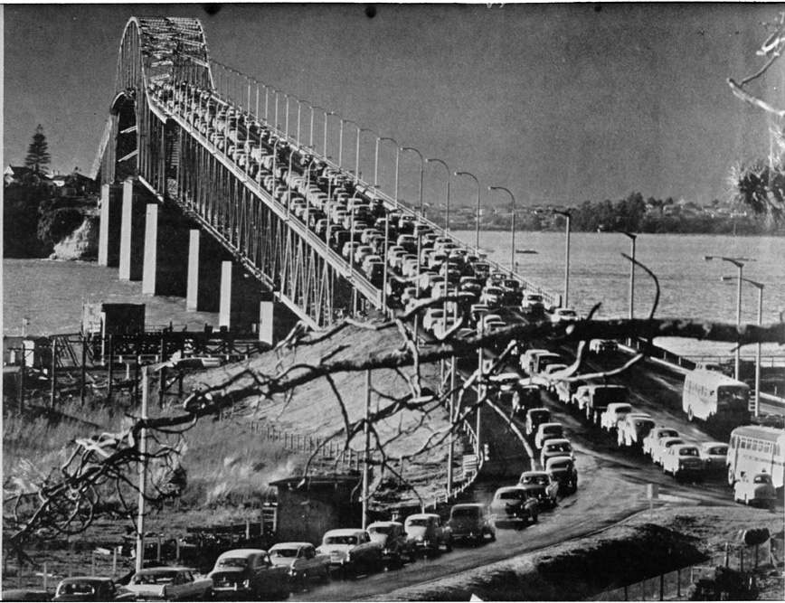
Auckland Harbour Bridge in 1959
The bridge was famously built as a scaled back version of what was originally intended in order to save money. Instead of a 5-6 lane bridge with footpaths the government of the day cut it back to just 4 lanes and no footpaths – something still missing to this day, although Skypath will finally sort that out.
While the decision to cut back the bridge to four lanes has often been suggested as on of Auckland’s biggest planning failures, the addition of the clip-ons has resulted in the bridge having more vehicle capacity than it would have had otherwise. That means those clip-ons have probably saved us billions in not having to build another road crossing.
https://youtu.be/pjFvU3m1DMA
When the clip-ons were added, only about 32,000 vehicles a day crossed the bridge but that number has increased significantly over the following decades. The 2018 numbers have recently been published and show that just over 171,000 vehicles a day cross the bridge. This means that since the bridge opened, just under 2.3 billion vehicles have crossed it. The only part of the motorway network carrying more vehicles than the bridge is SH1 just south of the city, between Grafton Gully and Gillies Ave with the section between Khyber Pass to Gillies Ave averages over 200k vehicles per day).

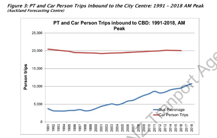
But while the number of vehicles crossing the bridge hasn’t increase much over the last decade, the number of people crossing the bridge has continued to increase. This is largely thanks to the Northern Busway and other PT improvements. As a result, at peak times now more than a third of people crossing the bridge are doing so on a bus. This data also suggests that most of the vehicle growth we’ve seen over at least the last 30 years has occurred ‘off-peak’.
Transport and land use are two sides of the same coin and perhaps the biggest transformation the harbour bridge had was to open up the North Shore. It effectively shifted the shore closer to the city, converting it from a series of largely sleepy seaside villages and farms to a major urban area home to over 260,000 people. Although some residents seem to still think it’s a sleepy seaside village. The image below shows what the North Shore looked like from the air in 1959 about when the bridge opened (from the Council’s GIS viewer). Most development was around eastern beaches.

Not only did the Harbour Bridge reshape the North Shore, it also transformed the area south of the harbour too, and not in a good way. The Central Motorway Junction was carved through the city displacing thousands and has long acted like a noose around the city centre’s neck. But many might be surprised to learn it was not part of the original motorway plans. They would have seen a route more like the Western Ring Route be the main road though Auckland with the central city served by an earlier version of the City Rail Link. The Harbour Bridge changed this though as local politicians wanted to ensure there were enough cars crossing the bridge and paying the tolls to cover the loan to build it. As such, they advocated for the bridge to become part of State Highway 1 and that meant it needed a connection to the rest of the motorway network, ultimately resulting in the CMJ.
Perhaps what’s most exciting about the bridge is that finally, at over 60 years old, it will soon have added the thing it should have had from day one, a way to walk and cycle across. This will come thanks to plans announced by the NZTA last week.

Perhaps tied in with the addition of Skypath the NZTA could also look paint the bridge something other than boring grey. They could treat it a bit like the Eiffel Tower which changes colour from time to time.
Since shortly after the bridge opened, there has been talk of building another road crossing to the city. Increasingly it is becoming clear that this simply can’t happen. The most recent information from the NZTA shows that building another road crossing, even with road pricing to limit demand, will result in worse congestion and is a waste of money. What would help though is building a dedicated public transport crossing, most likely light rail. We’d love to see a bridge be considered instead of a tunnel so that those using it can enjoy the view – at the moment crossing the bridge by bus, especially at the top of a double decker, provides one of the best views there is of the city. It would be a shame to lose that.

 Processing...
There’s a strong case to be made for City > SH1 to Constellation > Westgate > City as a ‘CRL 2’ in the coming decades. Given the limited industry on the Shore with a use for HR and the limited space for a freight yard, plus everyone strongly leaning towards the North Auckland Line hooking up with the Western, a dedicated LRT crossing has to be a dead cert for some time between now and 2050.
There is. The big mistake was not providing for intensification at Constellation Drive. It should have been at least a Town Centre and if not there then at William Pickering. Instead they took the view that motorway corridors should pass through an area and not serve an area.
But RTN from Constellation to Westgate and back to the city makes complete sense.
Thank-you… if you check the CFN, and now the official RTN, it’s there.
Need to start it like we did the Northern Busway, get the key stations in and run shoulder lane buses to start. The NB has shown how to do ‘Radical Incrementalism’™
This for me is the missing piece of the puzzle – no one is producing designs of stations and showing them in areas like Hobsonville, Tat Pen, Massey, Westgate etc and saying “This is what you could have” to get people on board.
For instance, I have never once seen a render of what Light Rail would look like in Westgate; where it’s going to go, etc. Dom Road, Queen St, etc yes. But showing people in the burbs what their rapid transit could be like is going to be more effective at creating buy-in than nothing at all.
Yes. Inspiration through information.
Couldn’t agree more…even a couple of shots of LR on Queen Street and Don McKinnon Drv got people excited. Do that in suburbs, with times tkane to get to palces they might want to go etc..can even throw some Balloons, Seagulls and possibly an Audi into the renders to keep it Auckland.
BWiz, that’s a great idea, I often thought what the LR rails and route along SH16 from Westgate to Kumeu would look like and the stations at Westgate and Kumeu.
If there were renders created for these the only problem I see is that it gets people thinking ‘what if’ but may also create an expectation. This could be a pressure that neither govt or nzta want to deal with.
What is the story with extending the Northern Busway to go over the bridge? It should be easy enough to justify that, shouldn’t it?
The problem for buses is in the evening peak. Northbound buses are slowed by being stuck with general traffic. The morning peak doesn’t have much of a problem since they run the bridge with five lanes south but only have four lanes of traffic feeding them. No idea why they do that but it means traffic on the bridge southbound travels at speed.
A simple T3 lane across the bridge northbound would fix the issues without reducing capacity.
The bridge is NOT the problem. Curran St merging is north bound, and city bound the buses have no issue forcing their way in, Ritchie’s are especially terrifying to watch their speed versus the much slower traffic they merge into.
Birkenhead Transport before going defuncted and the other companies are a lot safer merging.
Yes if you cross the bridge during the evening peak you can see the buses getting stuck in stationary traffic between the Fanshawe Street on-ramp and the bridge.
Given that the rush hour traffic is 50/50 between driving and buses, you would think that at least buses can have 1/5 of the lanes.
It wasn’t financial prudence that put the bridge where it is, it was the ego of Allum:
“This lack of foresight and common sense was compounded by Auckland city fathers led by former Mayor Sir John Allum, chairman of the bridge authority. He lobbied the National Roads Board to reconfigure State Highway 1 from its previous designated route around the city (ironically about where State Highway 20 is being retrofitted now at enormous cost) to a route directly through the centre of suburban and inner-city Auckland (causing great damage) and on to the bridge.
As former National Cabinet minister W.J. (Jack) Scott recalled in May 1999, State Highway 1 was moved because Sir John feared the toll revenue would be insufficient.
Sir John, he said, “had never been associated with a failure. No way was he going to run the bridge at a loss.” It was Jack Scott who pointed out that originally the southern and northwestern motorways were meant to be linked as ring road around the city – not slicing through it.”
-Michael Lee (Jun 1, 2009). Michael Lee: Sins of the fathers – legacy of harbour bridge.
I love this little factoid too 🙂
“At the 1953 mayoral election, Allum was defeated by J. H. Luxford who claimed the bridge would place untold costs on ratepayers for upgrading roads.”
-John Roughan (Aug 27, 2010). Auckland: The bridge builders.
Good to see Curran St onramp was shit even then!
The clipons were an engineering feat of fine Japanese engineering. IHI is a very accomplished company who make an array of things.
And some of those cars are to die for, I’m sure Heidi who is a closet cubic inch enthusiast will agree 🙂
Agree, great collection of cars. I imagine you would be able to see the fuel gauges going down in many of them!
I had to look up what cubic inch enthusiast meant, and you’d probably be right. This is what I pushed my babies around in: https://i.imgur.com/zCTkgG3.jpg
So yeah, if cars were my thing…
Ha ha. Go Heidi!
That pram is very similar to one we pushed our babies, toddlers and groceries in a generation ago, though it feels like just the other day.
Good to see the cargo-carrying-tray thingy underneath. A very useful feature for slashing grocery-shopping carbon-emissions and saving the planet. Everyone should get one. Plus you get a complimentary workout pushing 50Kg of kids+stuff up some of Wellington’s steeper streets.
I’m a bit out-of-touch now, but I wonder if anyone has come up with an e-pram yet?
sadly yes.
I don’t really like the idea of LR as a bridge. I feel like a more direct route would be possible with a tunnel rather than having the route meander through Westhaven it could emerge either onto the street or into a cut and cover tunnel in Wynyard before proceeding to Aotea. Plus I feel like it would detract too much from the present aesthetic of the Harbour Bridge. Two bridges without much separation would look really wonky.
Why would it meander through Westhaven? And why wouldn’t a tunnel equally meander? You still have to site tunnel portals somwhere, alight the tunnel with favourable geology, and run to and from them.
As for two bridge without much separation, separate them then! Make the new bridge direct.
1. I’m assuming it would follow the current SH1 through St Mary’s Bay, which has several curves.
2. You could either have the portals at Wynard Point (for example where the kink in Brigham Street is) or, if we were being really ambitious, just tunnel straight to Aotea using a cut and cover through Wynard and Vic Park.
3. Do we really want a bridge coming into Wynyard? Even if it’s only for LR it’s still going to massively change the ascetics of that area.
1. why? that’s not direct it’s just the way route… who wants to be there?
2. if tunnel yes could go to Aotea with a Wynyard Station and that would be ideal if a new system is used, like driverless Light Metro. But then the cost is great immediately; the option to stage and throughout with surface LR is lost.
3. An LR cycling/scooting/walking bridge could be great from Wynyard Pt and LR through Wynyard, also great.
1. It’s the route that requires the shortest bridge, presumably making it the cheapest to build and therefore a tempting option for NZTA and the politicians.
2. Surely there is nothing to stop a tunnel coming up in Wynyard Quarter somewhere and surface running from there to Aotea.
3. Maybe but people are getting sensitive to further intrusion into the Harbour like at the port. How will people react to a second 45 metre high bridge?
I’m not saying a bridge isn’t a good idea. It’s just there are other considerations than preserving the view for patrons to consider.
Last sentence should read.
I’m not saying I can’t be convinced that a bridge is a good idea. It’s just there are other considerations than preserving the view for patrons to consider.
I like the idea of bridge first. Future plan is, probably when most but the youngest of the readers of this blog are long gone would be a tunnel from Aotea to Takapuna direct or under the Onewa interchange.
An extensive government inquiry back around 2006 concluded that a second harbour crossing will be needed (because the already handled with kid gloves clip-on’s will have to come off one day) and that the best option is a tunnel.
Even though this inquiry was pretty solid and this tunnel would benefit public transport more than anything; the people on this blog seem to have been convinced by this Nick R that it can’t possibly happen. Even though this is the same person who thinks that Manukau harbour should be used or that the mainline-using (with level crossings galore) Auckland suburban rail network is somehow rapid transit for some reason they take his word like gospel. They pull every gymnastics to try and discredit the government report.
I think they might be against the tunnel because they know that it will be expensive and will therefore deprive funding for their silly light rail to the airport (which they want built ASAP).
I’m still expecting the second harbour crossing as a tunnel and and clip-on removal to be the next big Auckland transport infrastructure project once the CRL is done and dusted.
13 years has seen a lot of change in the world and especially in AKL. Work on any additional crossings has been ongoing since and thinking now isn’t what it was in 2006.
Last time I went to Auckland It didn’t look like it had changed all that much.
Thinking may have changed.But the cold hard facts about the nippon clip-ons has not. At some stage “thinking” will have to change back to facing reality.
I just wrote and published a post with data showing how much AKL is changing. Which beats whatever observations some occasional visitor may have.
Also it is well known that unless NZTA suddenly stop maintaining the clip ons there is no issue with their well being. Perhaps you have heard they are adding a new path to the bridge? Maybe not.
Regardless, you seem a little more out of touch with the reality here than your forcefully expressed opinions warrant.
Why are you so rude Patrick? Your words are just an opinion, no more or less valid than Daniels. Day by day you sound more like Donald Trump 🙁
“Your words are just an opinion, no more or less valid than Daniels.”
Opinions can be more or less valid. Patrick’s opinion is based on empirical data, Daniel’s is based on an impression from two visits to Auckland.
That is not true SB.
‘it is well known that unless NZTA suddenly stop maintaining the clip ons there is no issue with their well being’ is nothing more than an opinion dressed up as a fact.
Any engineer will tell you that the clip ons do not have an indefinite life and will eventually be replaced, either because of fatigue or the CBR of maintaining them becomes negative.
There is no need for such rudeness in these forums, Mr Reynolds may well be approaching 60, but there is no need for him to turn into a biter old man.
“Any engineer will tell you that the clip ons do not have an indefinite life and will eventually be replaced, either because of fatigue or the CBR of maintaining them becomes negative.”
Except for the several engineers on this page who haven’t said this, or the engineers commissioned to assess the structural integrity of the bridge. There is no reason why almost any steel structure, well maintained, cannot be used indefinitely.
The concrete piers on the bridge are probably more likely to fail as they are literally in the sea.
“Also it is well known that unless NZTA suddenly stop maintaining the clip ons there is no issue with their well being.”
The fact that considerable money has to be spent on this ongoing “maintenance” does not ring any alarm bells?
And exactly who are you to declare that something is “well known”?
Because I’ve always understood that there’s going to be some point when maintenance will no longer cut it.
deleted. boring ad hominem.
‘Patrick’s actually the owner of this blog.’
You’re really not big on facts are you!
By Sailor Boy:
“Patrick’s opinion is based on empirical data”
Hahahahahaha! What empirical data where?
C’mon let’s see it.
“Except for the several engineers on this page who haven’t said this”
And where are these engineers on this page? Where are they?
I’m an Engineer. I know that what is essentially supported by brackets that are tangentially thru-bolted is inevitably going to fail at some point.
” or the engineers commissioned to assess the structural integrity of the bridge.”
Where is their statement?
“There is no reason why almost any steel structure, well maintained, cannot be used indefinitely.”
Hahahahahaha! Actually there are plenty of reasons why it can fail nonetheless. Among them; the fact that it’s inherently not structurally sound.
“The concrete piers on the bridge are probably more likely to fail as they are literally in the sea.”
I think this tops them all for Sailor Boy’s complete pulled-from-bottom nonsense.
In any case; what do you imagine the clip-on’s are actually clipped on to again?
@jezza;
Now you’re just getting really petty and silly.
So if he’s not the owner of this blog, then why is he the moderator and why do al references to it express it as such?
If you can’t even figure out the relatively simple administration and moderation structure of this blog then it’s not filling me with much confidence on your ‘expertise’ on any other topics.
SB – are you a structural engineer? Do you know these things as facts? I have an engineering degree and you don’t sound very qualified.
Happy to hear from any NZTA engineer that is working on the Harbour Bridge, but until then, I am sorry, but I can’t take your comment seriously.
I’ll just leave this here for all you men of infinite knowledge, the source is NZTA 2016. It is not my opinion that the bridge can be managed structurally for a long time, but rather NZTA’s. In fact the word they use is indefinitely, which, as a non engineer, I understand to mean quite a long time:
https://www.nzta.govt.nz/assets/projects/auckland-harbour-bridge/AHB-Newsletter-October-2016.pdf
And again:
“As long as the live traffic load is carefully managed, the bridge can continue to be used *indefinitely*.”
https://www.nzta.govt.nz/projects/auckland-harbour-bridge/barrier/
They release a new study every 10 or so years and every one has had the date of clip-on replacement moved further into the future. The 2003 one had them needing replacement in 2020, I don’t think that is the case anymore!
I’d personally take the one released by NZTA earlier this year as the most credible source as it is the most up-to-date, but I’m sure you have your reasons for believing in an older piece of work.
Oh but apparently the NZTA is in disarray and is pro-road, etc….
…when it suits people.
Not sure what your point is there. Are you suggesting that because the NZTA is supposedly in disarray that there most recent report is not reliable? I don’t think there is any suggestion that any disarray is causing a reduction in quality of work.
Well it sees a strange about-face from them. Especially after it’s leadership has resigned.
And it seems an odd double standard how the people who post on this blog usually completely rubbish anything to do with the NZTa (with accusations of it being pro-road).
Not sure the leadership resignation would have much to do with it, it is likely a report that has been worked on for a while.
I don’t think it is an about face, more an evolution of understanding as more knowledge is gained. There is nothing particularly unusual about this.
Daniel, you make some excellent points but you are definitely wrong that NickR has somehow convinced ppl of this blog that harbour tunnel can’t happen. He hasn’t.
Can you cease your vitriol directed towards NickR? it’s achieving nothing and gives the impression you are more interested in attacking his credibility rather than discussing GA posts. Thanks.
“the same person who thinks that Manukau harbour should be used”
As did the Port Future Study; an independent study commissioned by Auckland Council. :
http://www.portfuturestudy.co.nz/docs/pfsconsultantsreport072016.pdf
Ref. page 169 Overall Quantitative Analysis. Of the options for a possible port location the 3 potential locations in the Manukau Harbour received the 3 highest ratings.
Maybe you should read it.
Well considering that amongst that 230 pages of glossy dross; there is absolutely no consideration whatsoever given for the physical reality of the extremely high sedimentation in Manukau harbour and how any attempt to make it a major port would be made impossible no matter how much continual dredging it got…
…all that report tells me is that Ernst & Young’s NZ office are incompetent.
I haven’t read the report. But if you hold down the control key and the “F” key at the same time it comes up with a little box that you can write something in, like “sediment”. That makes it easier to find things. The section about sedimentation starts:
“Considered together, the influence of tide and waves means that the surficial sediment in the vicinity of the Manukau Heads can be expected to be highly mobile and the possibility for bedforms of some description being formed is likely.
Sediment transport on Auckland’s West Coast is dominantly from south to north, driven by the predominant wind and wave climate from the southwest –occasional reversals occur during northwest wind and wave conditions. Various estimates have been made with respect to sediment transport volumes, with total gross sediment transport rate across the harbour entrance (in both directions) is likely to be of the order of 275,000-375,000m3per annum. It is likely that volumes of the order of 200,000-250,000m3per annum will require dredging. Dredging would be required through the terminal lobe of the ebb-tidal bar, a distance of approximately 4 km.The strong currents of the ebb-tidal channel mean that sediment that is transported into the channel is likely to be spread out along the length of the dredged channel. Based on the only other entrance channel on the West Coast, and the dredging requirements of other New Zealand port entrance channels with similar sediment transport rates (Taranaki, Tauranga and Otago) this would likely require annual dredging. However, numerical modelling reviews of similar sites would be required to provide a better idea of the distribution of sediment and likely dredging regime. Due to the predominant south to north sediment transport regime, sediment bypassing would be required to ensure the health of the coastal sediment transport system (i.e. Auckland City’s West Coast beaches). Dredged material would be deposited on the northern side of the entrance channel in a nearshore area where it would not be lost from the nearshore sediment transport system. A similar dredge disposal bypassing is undertaken at Port Taranaki. Identifying the location of deposition to best work with the existing sediment transport system will require targeted fieldwork and numerical modelling…”
“It ain’t what you don’t know that gets you into trouble. It’s what you know for sure that just ain’t so. “
Looks like you have dredged yourself a big hole there, Daniel. Best stop dredging.
Yes Heidi I saw that. And yes I know how to use the search tools.
That load of nonsense you’ve quoted was all I needed to know that there is absolutely no consideration whatsoever given for the physical reality of the extremely high sedimentation in Manukau harbour. The fact Manukau is even being compared to east coast ports like Otago or Tauranga further underlines how useless whoever did that report is and how little actual research they did. It’s even common knowledge that the entire west coast of NZ has extreme issues with sedimentation. That’s why Port Taranaki, aided by the steep volcanic slopes, is the only remaining major port on the entire western seaboard and all the other remaining major ports are on the east coast or somewhere unaffected by this sedimentation.
You only have to go and visit the said Manukau harbour to see with your own eyes why this idea of having any major port there is absurd.
If Manukau harbour could’ve ever been a viable port for anything except small vessels; that’s where Aucklands major port would’ve been all for of these decades. Because until about 40 years ago; most of NZ’s ships went to/from Australia or the UK.
It’s simply an unworkable idea. And the only revealed thing here is how incompetent the consultants hired by Ernst and Young (NZ) must be.
LOL MFD not only are you making yourself look stupid, but you’re also showing yourself up as someone lacking a bit of social decorum. 😉
Daniel, “there is absolutely no consideration whatsoever” was not correct, though, was it?
I suspect our good east coast harbours have blinded us to the reality that many countries have used harbours much more like the Manukau for their ports, because that’s all they’ve had available.
What would help a lot more than excited pronouncements of “incompetent” consultants would be some links to articles or research which could build up our readership’s understanding. “You only have to go and visit the said Manukau harbour to see with your own eyes” doesn’t quite cut it, I’m afraid.
“Daniel, “there is absolutely no consideration whatsoever” was not correct, though, was it?”
No it’s entirely correct. Whatever bumbling little crap-talker put that load of dross together clearly neglected to do any research whatever into that salient, crucial consideration.
Manukau harbour would need continual dredging to allow big container ships to traverse it, not a mere dredging every couple of years like Otago and Tauranga get. And it would be out of action until dredged enough everytime a storm hit.
“I suspect our good east coast harbours have blinded us to the reality that many countries have used harbours much more like the Manukau for their ports, because that’s all they’ve had available.”
And which countries would those be? C’mon start naming them.
You seem oblivious to something. Manukau harbour does actually have a port facility at Onehunga which has been active over the decades. The fact is that it sees little usage these days and only from shallow-hulled vessels (mostly from another west coast harbour, Westport), although back in the days of smaller sailing boats it saw a fair bit more. But as ships got bigger it fell into the same decline as:
* Port Waikato
* Patea
* Wanganui (which had several sedimentation-related shipwrecks BTW)
* Westport
* Greymouth
* Hokitika
Now especially in the case of Wanganui and Port Waikato; there’s a pretty sound reason for that.
To repeat: If Manukau harbour could’ve ever been a viable port for anything except small vessels; that’s where Aucklands major port would’ve already been all for of these decades. Because until about 40 years ago; most of NZ’s ships went to/from Australia or the UK.
“What would help a lot more than excited pronouncements of “incompetent” consultants would be some links to articles or research which could build up our readership’s understanding.”
Here, google is your friend: https://www.google.com/search?ei=1bLxXOKPJJbez7sPrsuKiAg&q=sedimentation+of+manukau+harbour&oq=sedimentation+of+manukau+harbour&gs_l=psy-ab.3..33i22i29i30.4682.10793..10929…1.0..0.225.4677.0j31j1……0….1..gws-wiz…….0i71j0i131j0j0i67j0i131i67j0i10j0i10i30j0i5i10i30j0i70i249j0i22i30j33i160.3oZGs_DD73w
“doesn’t quite cut it, I’m afraid.”l
Well… …that’s your loss. Because doing that simple thing would be enough for most people with any physical intuition.
Daniel, what’s really silly is attacking people’s motives, rather than focusing on the issues.
Pro-tip: attacking people’s motives will detract more from your own credibility than the people you apparently dislike. And generally makes you look like a tool.
+1. Tool?
Yes, I haven’t heard much about the clipons recently, other than their lifespan is finite. Completely agree a second crossing is going to be required.
My prediction, knowing how Auckland works (all sides of politics), the action will only begin when one of the clipons undergoes *unexpected* structural failure in morning traffic. Lets hope loss of life isn’t involved.
I think the clip-ons are rigged with strain sensors galore. Of course that’s not a complete guarantee that some series of catastrophic failures might occur in a short space of time.
But I would not be surprised if some headlines hit about some sudden complete ban of all traffic on the Southbound clip-on some time that suddenly ends people ignoring this priority.
Anyone want to offer up odds on the mythical creature that is Auckland Harbour Bridge ‘Skypath’ actually being completed before Sydney cross-harbour metro project opens in 2024?
I’m not expecting it to ever be anything more than PR fluff until the clip-on’s come off of the AHB.
To start with, we should stop calling it ‘Skypath’ as that project is dead. My understanding is that the new and better NZTA design still has to pass a feasibility study and then it will be tested if 100M + is good spending or not on a few eager cyclists.
I actually love the new design, but I don’t expect it ever to be built.
Now that’s a negative, depressing thought. It may of course be right, given how ridiculously long it takes to get beneficial transport projects underway in this country.