Waka Kotahi/NZTA has released an important new document for our region: the Auckland Motorway Strategic Plan (AMSP), which is fully endorsed by the Minister of Transport Chris Bishop and Mayor of Auckland Wayne Brown.
It’s really very good; comprehensive and reality-based. As the Minister says in the official Beehive press release:
“Auckland’s motorway network carries around 1.5 million trips every day and is critical to keeping people and freight moving. As Auckland grows, we need to get more from the motorway network we’ve already built while continuing to invest where extra capacity is genuinely needed,” Mr Bishop says.
“In many parts of the network we’ve already widened motorways as much as is practical, so a shift towards a more balanced and strategic approach with targeted investment will play an increasingly important role.
“The Auckland Motorway Strategic Plan (AMSP) sets out how we will achieve that shift in approach over the next 30+ years as Auckland’s population grows beyond two million people. The plan focuses on three core outcomes:
- Optimising the existing network – making better use of the network we’ve already got through smarter traffic management, quicker responses to crashes and breakdowns, small-scale improvements, and delivering Time of Use Charging.
- Targeted increases in capacity – adding extra capacity where bottlenecks are impacting efficiency, progressively delivering rapid transit, closing critical gaps in active mode networks where they interact with motorways, prioritising projects to increase capacity and address resilience risks.
- Wider system improvements – improving the wider transport system, including public transport capacity, rail network improvements, and local roads/active modes, so fewer trips need to use the motorway network.
“This practical, long-term approach supports the Government’s focus on improving freight efficiency, building a more resilient transport network, and supporting economic growth.
“The motorway network is only one part of Auckland’s wider transport system. Keeping Auckland moving means making sure roads, public transport, walking and cycling connections all work well together,” Mr Bishop says.
It is hard to stress how much of a welcome departure this announcement is from the thinking and language of the previous Minister of Transport. For example, this sentence is nothing more than an anodyne statement of fact:
“The motorway network is only one part of Auckland’s wider transport system. Keeping Auckland moving means making sure roads, public transport, walking and cycling connections all work well together,” Mr Bishop says.
And yet what an enormous relief to hear it so robustly stated by the Minister, and to see the transport agency produce a comprehensive and well conceived unpacking of what this means for Auckland’s transport networks.
The plan, and the language around it, also represents official acknowledgement that we are done with the spread of the urban motorway network in Auckland, as conceived at the height of last century’s global motorway-mania.
Here it is:
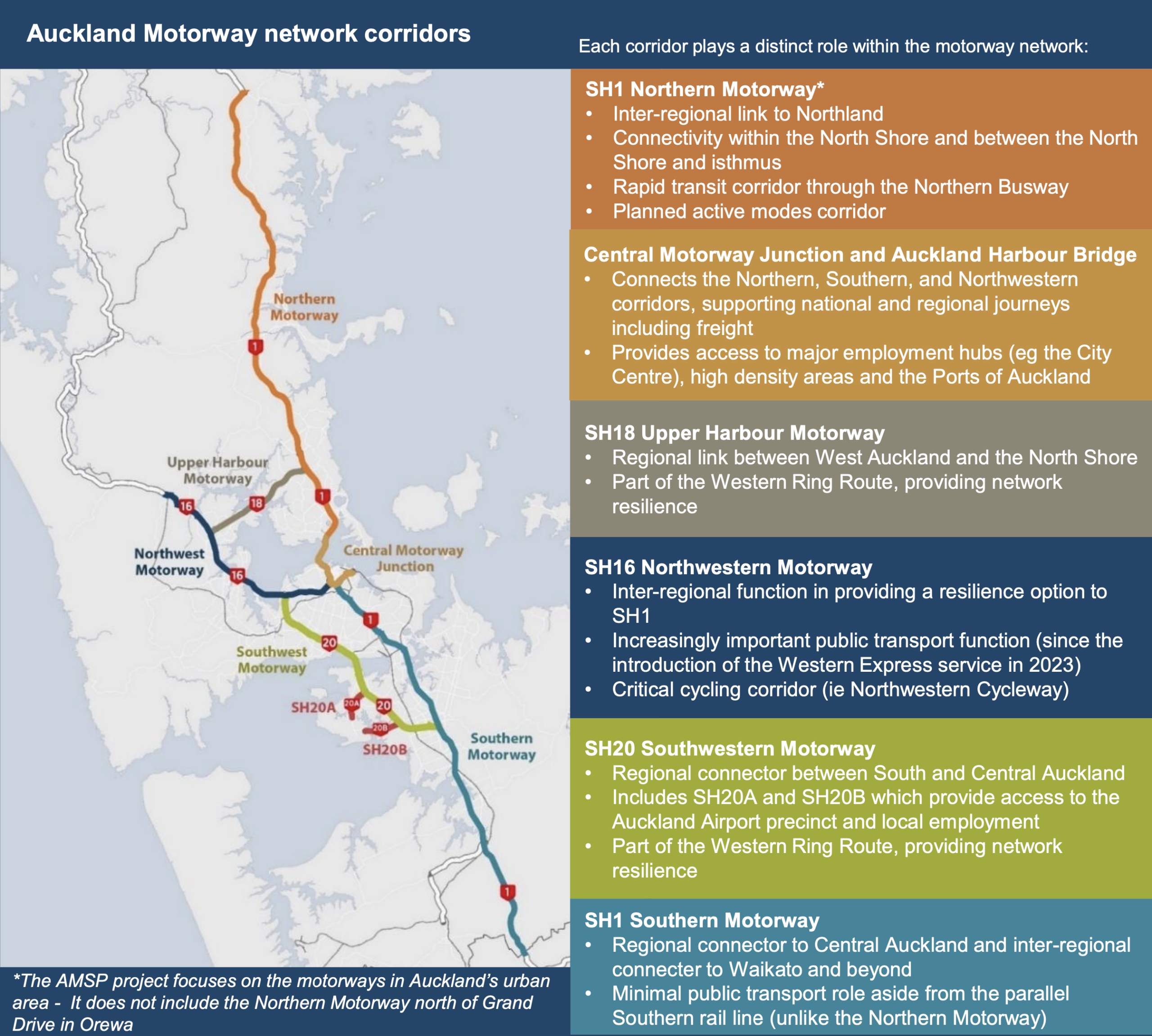
The complete Auckland Motorway Network, from the Auckland Motorway Strategic Plan.
This is the end of the post-World War II revolution in urban transport planning. Greater Auckland has long maintained that this vision is exhausted and no longer relevant for this century, so it is a great relief to at last have official policy and plans explicitly catch up to the reality.
The History
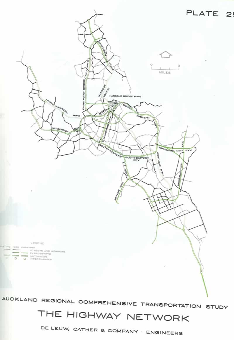
From the De Leuw Cather Plan,1965, showing proposed motorways across Auckland.
The basis of the Auckland Motorway Network pattern was set by the De Leuw Cather plan of 1965, which refined and confirmed the all-in-on-motorways direction of the city’s 1955 Transport Master Plan.
And yet, right from the beginning the 1965 plan proved unachievable: significant parts of it were either pushed off into infinity or quietly dropped.
The Henderson motorway was probably the first to go. The project of transforming Dominion Rd into a full motorway was actually begun, but only insofar as the stranded (and loathed) flyover interchange of Dominion Rd/New North Rd, which still stands as a monument to foolish notions, awaiting creative redevelopment.
The horrendous proposal for a double-stacked elevated motorway along Quay St (which would echo some ghastly waterfront motorways seen in coastal cities of the United States) thankfully didn’t make it from the 1955 plan to the 1965 one. In that respect, De Leuw Cather were a humane advance on the extremity of 1950s highway engineering.
The Kauri Pt harbour crossing has never been pursued, except recently by one Aucklander, basically because a better location was found for the same idea: SH18 and the Upper Harbour Crossing, which is the only motorway Auckland has which is not on the 1965 map.
The South-eastern Motorway cost another Mayor, John Banks, his job. He was the last champion of that terrible route. Its western end, the ill fated East-West Link, has only recently been properly killed off, alhough one bit between SH1 and MetroPort may return?
The Labour-led government believed it had nixed the East-West Link, but NZTA ignored them and kept pushing it through the design and protection pipeline, and it has only recently had an oak stake driven though its costly and wasteful heart.

Headline from Newsroom‘s coverage, July 2026.
The only new full motorway in the Auckland urban area that is likely to ever be built is the SH16 alternative route. A route that already carries way more traffic than Warkworth to Te Hana is ever likely to. On the assumption that is to be a full motorway and not just an expressway?
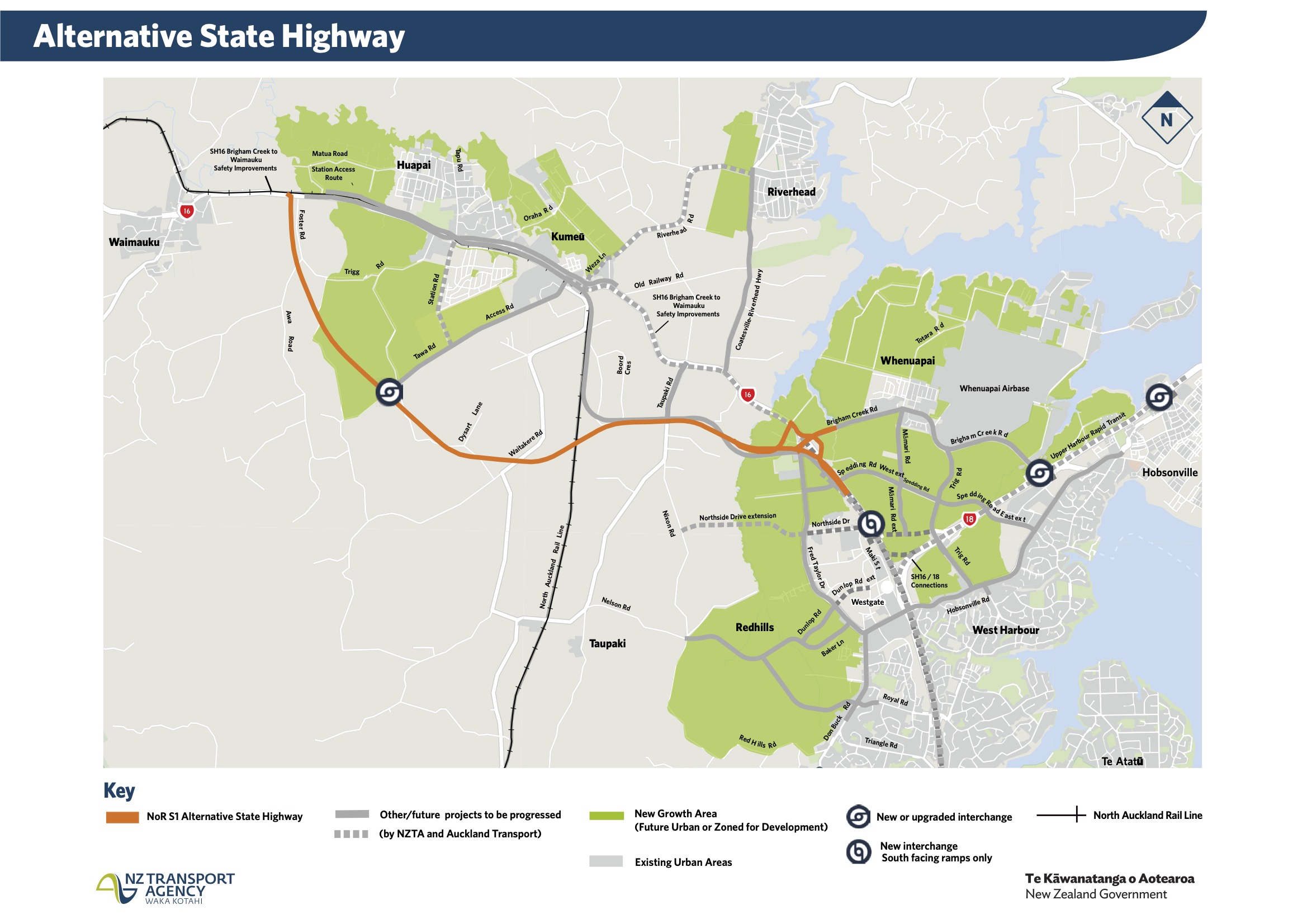
Alternative State Highway [sic], a Road of National Significance. Source: NZTA
And, that the best way to keep it functional is by investing in the alternatives: Rapid and Active Transit. To this should be added real demand management – hopefully via road pricing – because carrots and sticks are both essential to deal with the scourge of traffic congestion.
Hopefully, this plan heralds a new world in which all these parts of our transport system are understood together – and explicitly treated as such by our transport agencies – as interdependent, complementary networks and actions.
The way forward
This does not, of course mean the end of NZTA’s labours in the Auckland urban area – far from it. There’s still so much to do, but just not all on one mode, nor with one mindset. Per the NZTA project page, the-three part strategic approach is
- Optimising the existing motorway network (including time-of-use charging)
- Targeted increases in capacity (including rapid transit improvements, and fixing gaps in the active modes networks)
- Wider system improvements (including improvements to rail, bus, active modes, and local streets for local trips)
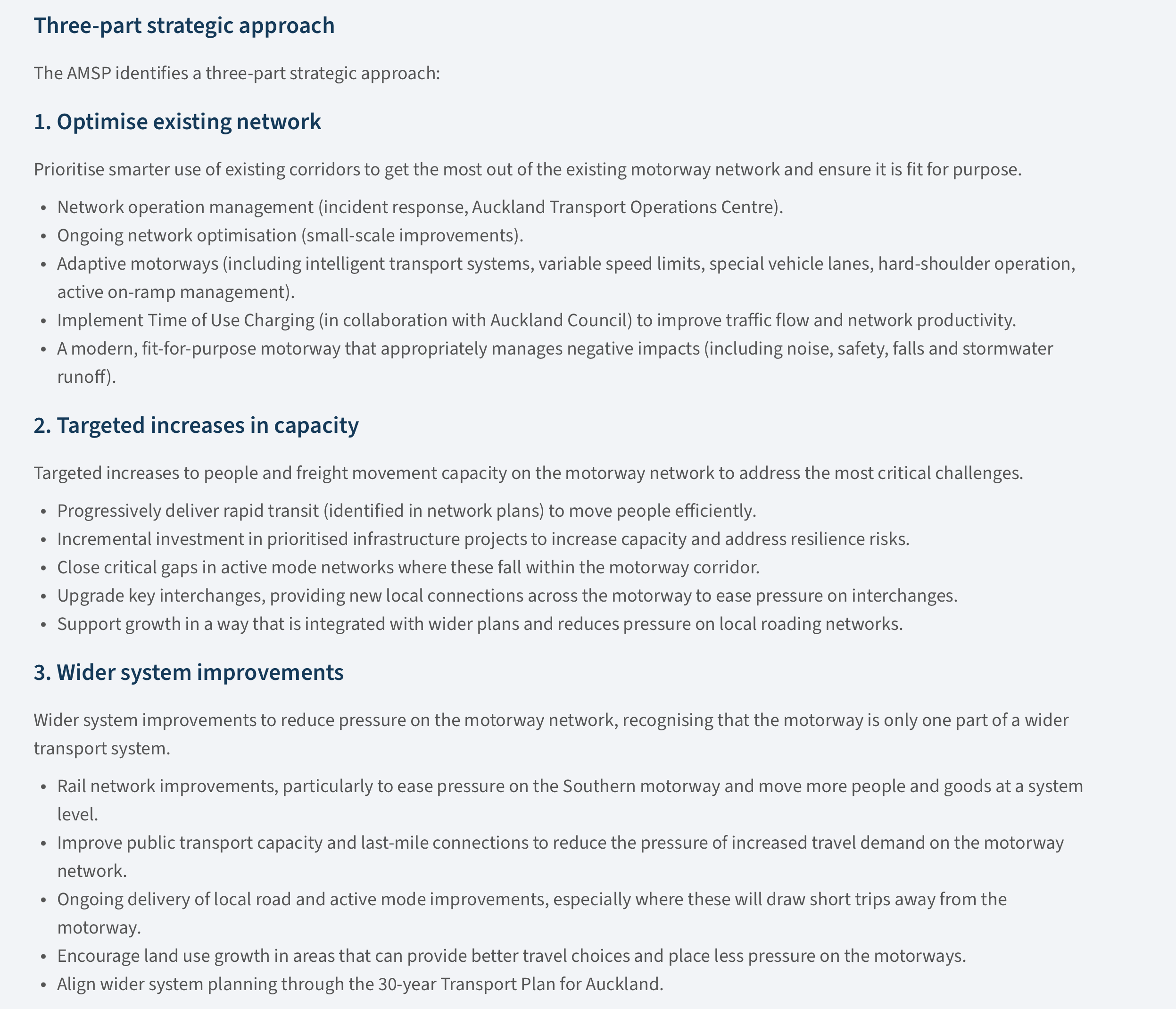
The AMSP strategic approach.
And here is the very busy plan in map form – see link here for full size:
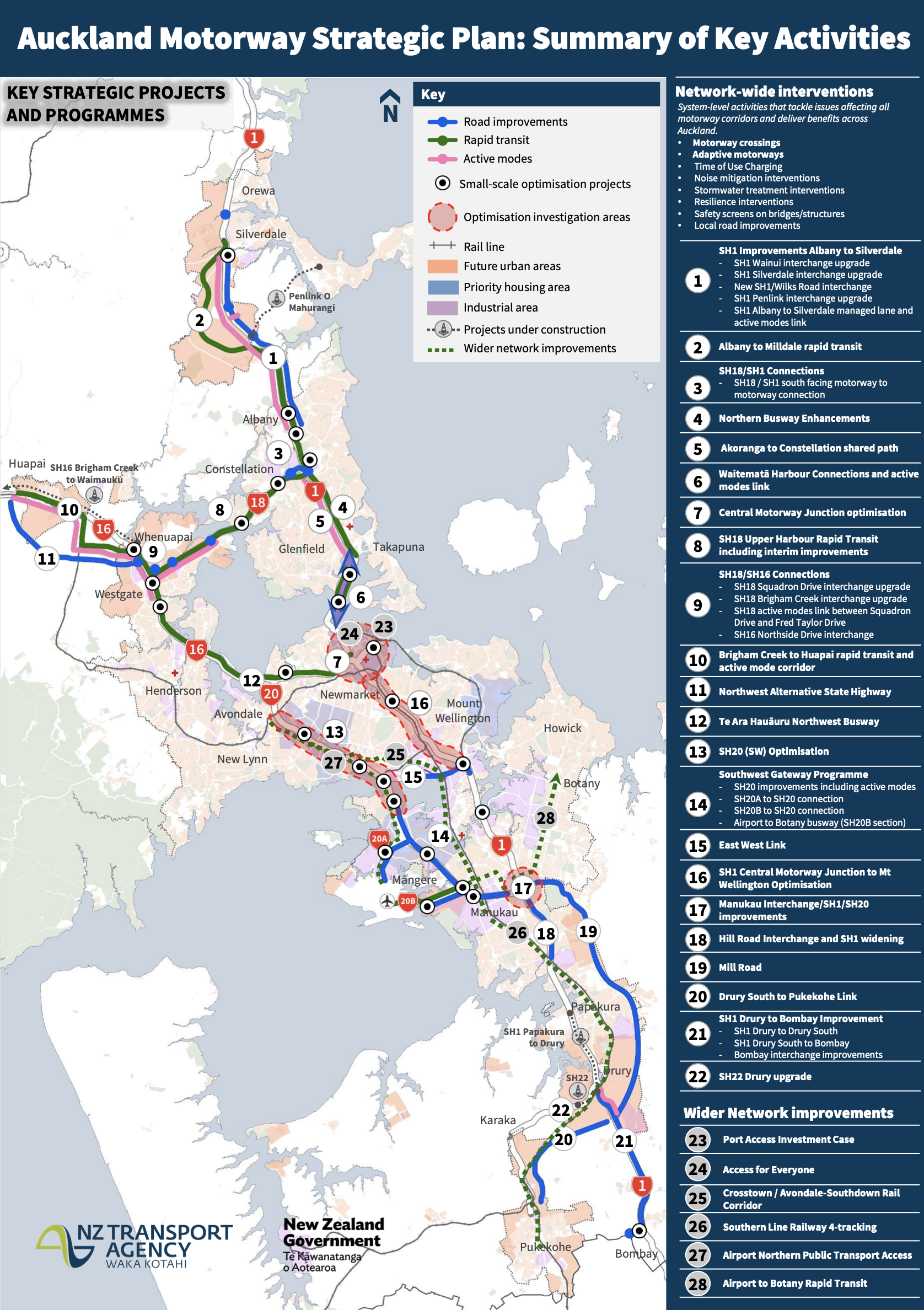
AMSP project summary
That’s a very long list of often very big projects, including:
- Te Ara Hauāuru, the Northern Busway (12), as currently conceived, is costed at around 1x CRL ($4.9b).
- All three stages of Mill Rd (19) looks like it will be even more than the CRL (~$6b).
- And whatever we might end up getting across the Waitematā will dwarf both of these.
On the rail network, urgent fixes include level crossing removals, plus a fourth track to Wiri, and a third to at least Papakura (ideally a fourth there too). Hugely valuable, too, would be a third freight bypass on the eastern line, as would fly-overing the Westfield and Manukau junctions. Not cheap.
There are smaller more valuable things here, like the urgent and long overdue sorting out of access to the Ports of Auckland in lower Parnell (23).
Pretty comprehensive, but there are still gaps. Plus of course the critically important question of what on this long list actually gets funding, and in what order.
What’s missing?
The most obvious glaring deficiency in rapid transit terms is the City-Centre to Mangere (CC2M) route, the site of the canceled Light Rail turned gargantuan Light Metro project of the previous government.
Canceling projects is every government’s prerogative. But to not replace it with anything and just leave that part of the map blank, is absurd. Although the southern part of the route does have a mysterious dashed green line titled: Wider Network Improvements. Which could mean anything.
But CC2M remains a key gap, long identified as such. For exmaple, here it is in the predecessor of the current work, the Strategic Public Transport map in the 2016 Auckland Transport Alignment Project (ATAP), as that grey line from Britomart – Mt Roskill – Onehunga – Airport.
The route demands light rail in the long run, of course. But what are the best options in the meantime? This is one of the city’s busiest bus routes, and will only get busier.
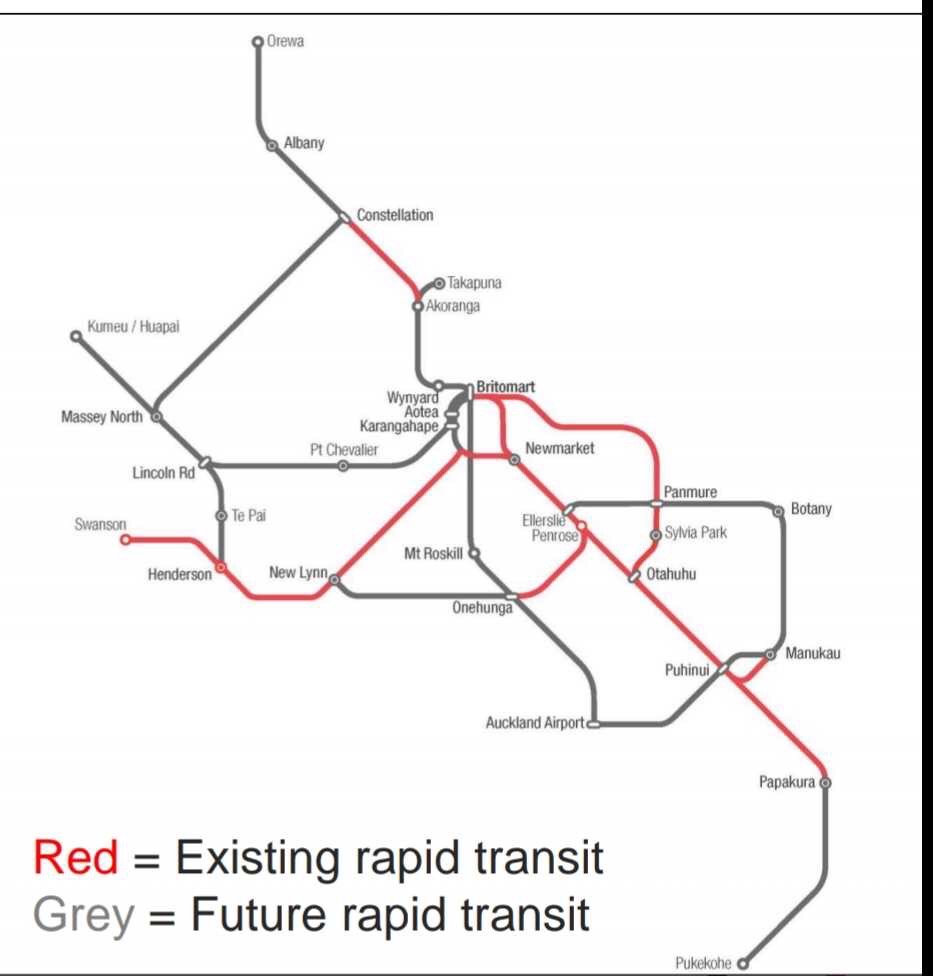
The “mode-blind” Rapid Transit Network in the 2016 Auckland Transport Alignment Project.
Active transport: walking, cycling and micromobility
It’s great to see the rehabilitation of this important mode, which not only accounts for many a first and last mile of trips by car and by public transport, but as we know also provides an affordable and healthy alternative for the many short trips that make up around two thirds of travel in our cities.
Moreover, ranges have been extended by electrified mobility (e-bikes and e-scooters and other mobility options), and stretches of long-distance dedicated infrastructure, many of which parallel existing or once planned motorways. For example, the Northwestern path runs along SH16 from Westgate to the city centre, and to the east Te Ara ki Uta ki te Kai links Glen Innes to the city centre, via the route of the ghost eastern motorway.
Here is the official Auckland Strategic Cycleway Network map for comparison. The darkest lines – Regional routes – are the most relevant here:
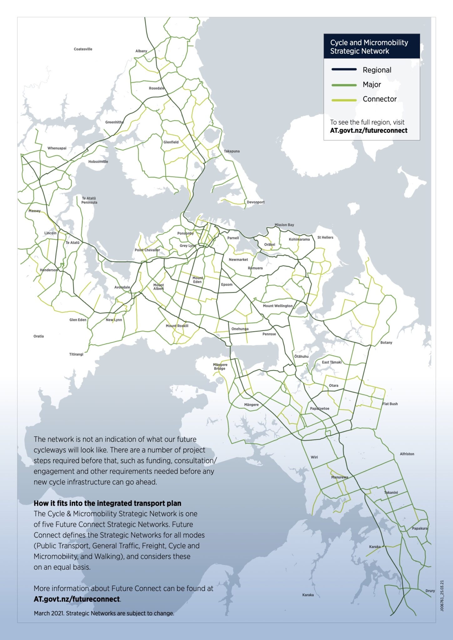
Auckland Strategic Cycle and Micromobility Network Map as of March 2021.
Large sections of this network were delivered and ugraded during a busy golden age of building bike/walk paths (including some beautiful bridges) to heal severance and improve access, as part of major motorway works.
All credit to the advocates who made the case during the Waterview Board of Inquiry for kicking off that era of strategic construction, building on the tenacious efforts of a previous cohort, on SH16 and SH20. That powerful community-led work normalised the idea that to be truly strategic, citywide networks must make room for all modes of transport.
It is true that in recent times, the completion of the regional (and local) cycle network has slowed alarmingly. But at the same time, it is also really encouraging to note that (almost) all the critical water crossings on the high-level network – especially those that previously made the Isthmus into an island – have slowly been completed (including the soon to open Orākei Basin section).
Of course there’s still one obvious and glaring gap!
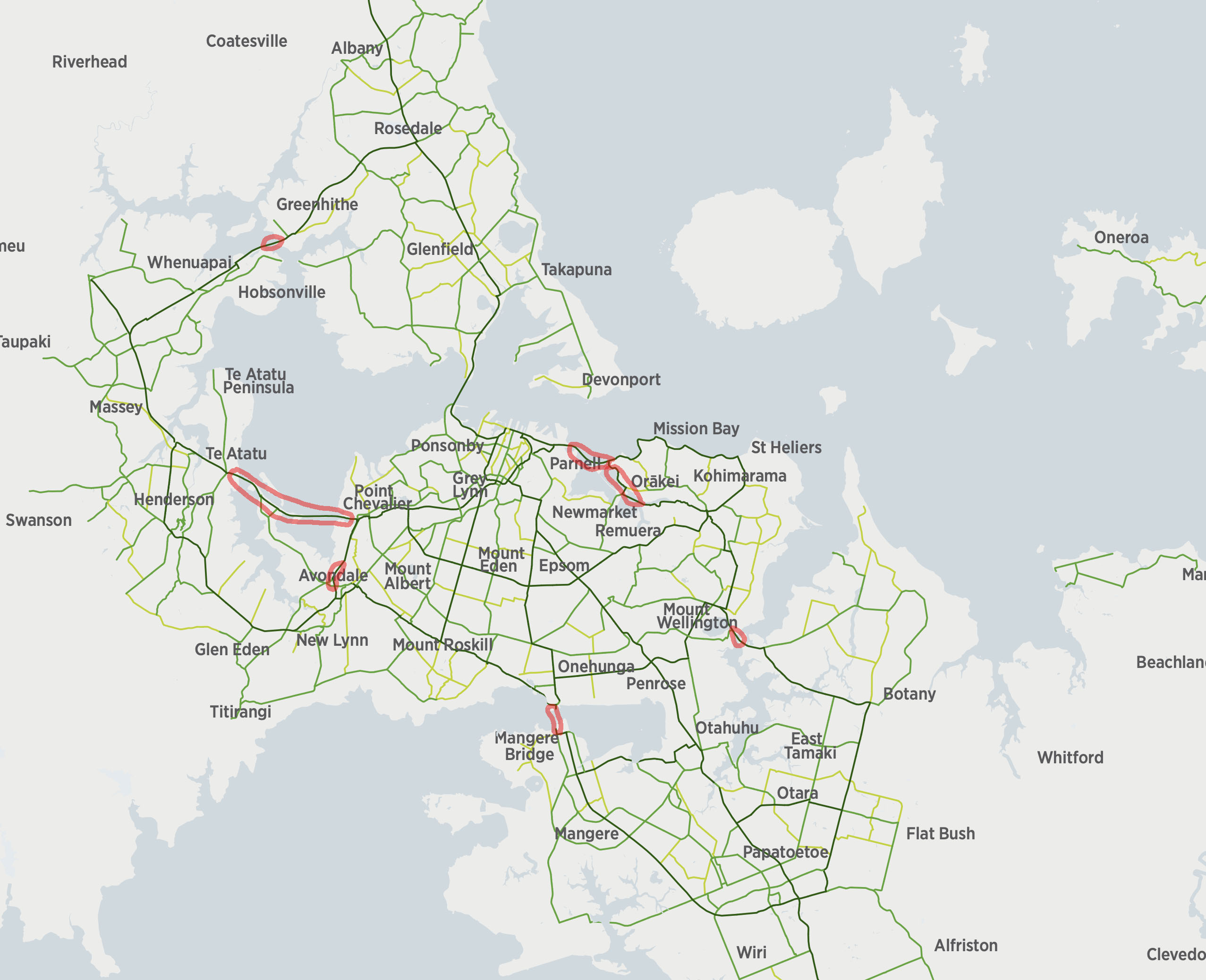
Auckland’s Cycle Network, with the key water crossings marked in red. Spot the conspicuous missing link?

Nga Hau Māngere, the new bridge for walking, cycling and fishing, as seen at the opening in 2022. It replaced the sinking Old Māngere Bridge, which itself was replaced by the New Māngere Bridge for traffic (which includes an accessway for walking and cycling, meaning the Manukau Harbour has two adjacent active modes crossings, while the Waitematā Harbour still has none. photo Patrick Reynolds
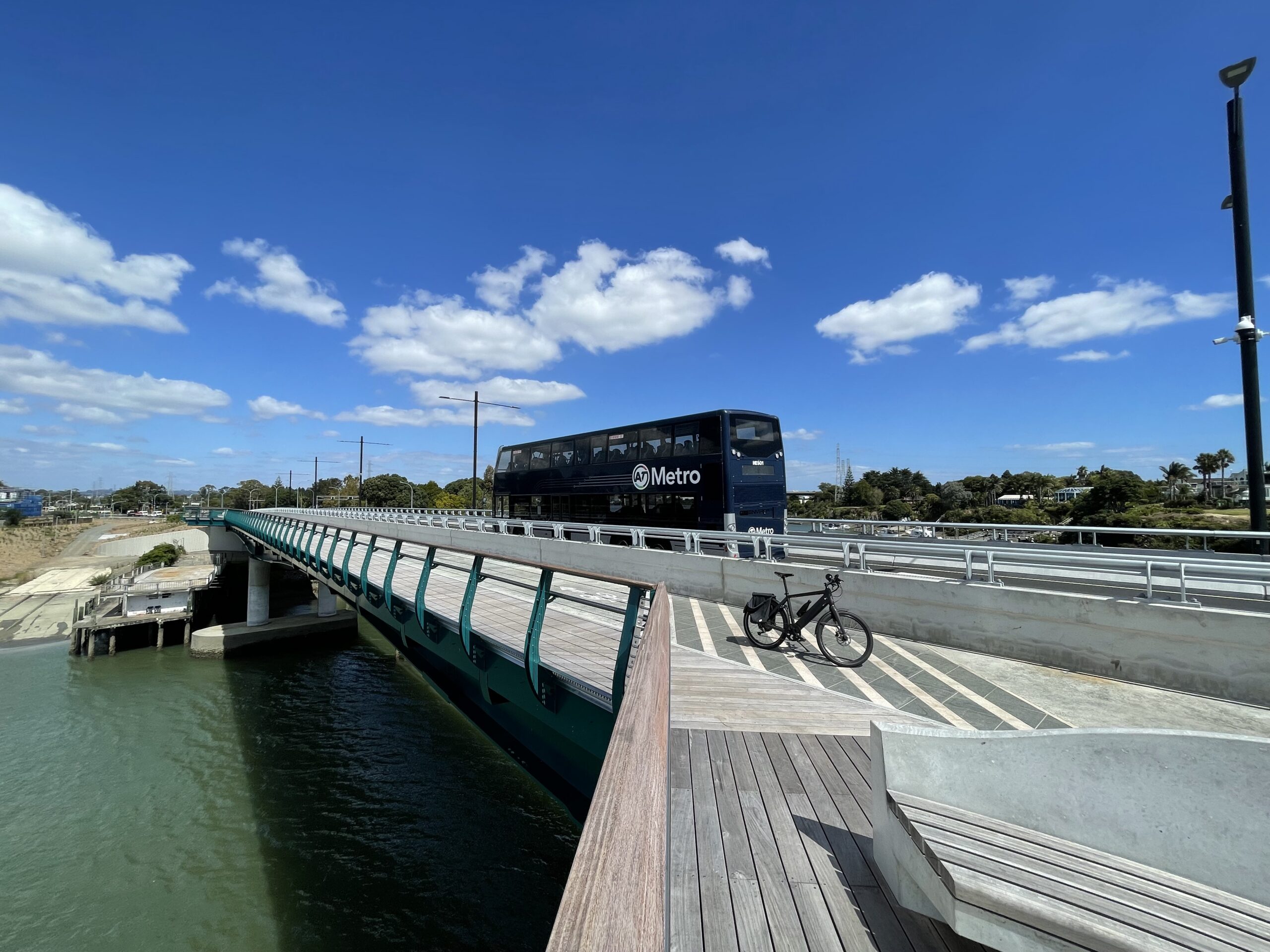
Tāmaki River transit and active bridge. photo Patrick Reynolds
Ranking
The full suite of projects indicated on the Auckland Motorway Strategic Plan can not be afforded anytime soon, even without politicians being politicians, so the real hard work ahead is prioritisation.
It’s great to see that Te Ara Hauāuru Northwest Busway has wide political support. However, it remains unfunded – and recent major party promises to freeze fuel taxes have cast a shadow over it getting under way any time soon, beyond minor improvements.
Road pricing, if done well, promises much – both in terms of network efficiency, and as a source of additional funding, especially for those complementary alternative mode projects. Given one of the immediate objections to time-of-use charging is “show us the alternatives”, completing the complementary networks should be an urgent priority.
Which projects would put at the top of your list? How would you spend any available budget? What are the quickest ways to achieve the desired outcomes, perhaps with interim designs ahead of more permanent ones?
Anyone up for building an Auckland Strategic Networks game, balancing the budget and the options?
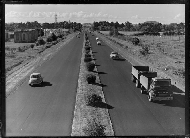
Auckland’s Southern Motorway, 1963

 Processing...
“Anyone up for building an Auckland Strategic Networks game, balancing the budget and the options?”
Great idea! Give people the options of what to spend funding on and see how the network performs. Choose to spend it all on roads, then see congestion. Choose to spend it all on cycleways and ignore road maintenance, then people can move and be healthy but freight suffers.
What remains very disturbing is the fragility of our entire planning system.
That the whims of one person when placed as minister of Transport, can have such a profound level of control over such a significant portion of government expenditure and our social and economic fabric.
The profound change in direction in transport planning, while very welcome, with just a change in minister just in the same government, shows the system is extraordinarily mono dimensional.
no so much “fragile” as “emotional”
The last GPS was a tantrum.
Got to balance it with not falling into a trap of bureaucratisation (where it becomes too hard to even do the ‘right’ things), but yes in general agree.
Minister’s job should be to set the overall direction and hold to account, the decision making around project prioritisation etc should be down to a well defined process.
Do you think we will ever see a plan to actively remove the Dominion Rd interchange and regenerate the area? I say ‘actively’ to refer to a 10-15 plan as opposed to just waiting for the bridge and other motorway infrastructure to degrade/get damaged in an earthquake.
I’d say only once property prices in the area rise again to some ridiculous level. Then some developer might offer the city (which will always be cash strapped) a deal.
Development of a new urban neighbourhood in the area currently occupied Dominion Road Junction is in the City Centre Masterplan. A lot of work went into it in terms of capacity studies, costings, etc. It’s a glaring gap in the urban fabric of the inner city and its anomalousness will become increasingly apparent once CRL has opened.
Loathed is so strong for Dom Rd interchange. Personally I don’t mind it, I agree it’s probably not the best use of space but I like driving through it as the speed limit is higher and there are less conflicts.
I agree. It’s nice in a car, not really as a pedestrian or cyclist though. I guess if they ever build light rail they could use the land to redesign it as a station and interchange, with space left for developments.
Favourable news on the interchange. The Auckland Urbsn Design Office is promoting what they call “Dominion Junction”, the concept of an urban renewal project for the blighted area around the flyover which would be demolished, freeing up about 3 hectares of Council owned real estate which would be worth over $100 million which could fund the work. I have been advocating this for over a decade and linking it to AT’s project to resolve the nearby George Street crossing and over 20 others on the Western Line. Hopefully AT will be in a position to indicate their preferred options in the next year or so.
That dom rd interchange would have been the better site for the Mt eden/ eden terrace crl station if only they had the political will to confiscate ian mackinon drive and say this is now a rail line/busway only.
Could have regenerated the area and not have Mt eden station in its current ultra hilly site.
Once mackinon drive, that travesty of a road, was for buses and the start of the crl then we could have buried it and reconnected eden terrace over the top of the rail line and station to heal some of the scars of the inner city.
Too late unfortunately.
Gosh this is all good. Did you know that it is only 2 months to the General Election? What a coincidence is that! How good to have the Minister who demonstrated that funds allocated for one purpose could be redirected to a cycle and walking bridge just like they can be redirected to any other pork barrel election project.
Simian Brown the primitive reptilian road transport brain of the National Party is currently maxing out on Health. Would anyone like to take a bet on whether he gets road transport back if they win the election? Even if he doesn’t there is the walking-dead, Hospital Matron Nicole Willis making financial decisions about ferries and, no doubt, about PPP for us all…. Meantime all you sensible decent cyclists and walkers still think that recreating the UK/London imbalance -a machine to produce deprivation and poverty – in our post-colonial paradise is a) good and b) inevitable. Who decided we should have 2 million (a conservative estimate according to some) people in one mega Zombie (thanks for this concept from the provinces to Shamabeel Equab) city? Why do you take this for granted?
The Northwest busway is critical given the massive increase in the amount of housing in Northwest and West Auckland, without equally increased businesses/workplaces and education, many people travel out of the area for work and school, and the traffic is diabolical.
“Optimising the existing network – making better use of the network we’ve already got through smarter traffic management”
This sounds like reallocating a lane for PT -would be a massive time and cost saving in getting people moving on the North West.
I feel like we’re closer to that becoming a reality than we’ve ever been in the past.
The challenge will be whether to wait for that time to come or get on and build it now. The lack of money might ultimately provide the answer.
We already do that on the North Western with buses on the shoulder. If there’s a way to avoid building mass transit in West Auckland, you better believe we’re already doing it.
Meanwhile, other parts of the city get fully separated busways and have had them for decades. Yet mop up a fraction of the growth the North West has over the last ten years.
But the buses on shoulders are only open for a short period of time each day and are not the length of the route.
The current plan specifically said it was not to impact on car traffic and lauds being better for car traffic even above its mention of PT.
The Shore has only had the busway since 2007/8. Technically nearly 20 years, but you’re over-egging the omelette slightly on that one, because there is similar growth happening further North (Orewa, Silverdale, Millwater, Milldale) and there’s no dedicated busway there either.
The other legacy of the Henderson Motorway is the overbuilt design of the Whau River bridge at Rata Street/Ash Street. It is built much wider than the 4 lane arterial road that uses it because the original design was intended for the motorway.
Which is lovely for walkers and riders.
Space for humans not “value engineered” into a grim punishment.
Sometimes, crumbs fall off the table for the non-car modes. Not the way it should be – but sometimes those crumbs DO contain seeds of something great (Looks at Nelson Street off-ramp / Lightpath).
It’s nice, but feels like they could expand it to 3 lanes westward there with a left only lane. As there is plenty of space.
Maybe get rid of parking on Ash and have bus priority.
I didn’t think there were many bus routes along it? As the 18 etc. turns down through Avondale and goes direct to New Lynn. Otherwise I’d suggest turning it into one lane bus lane and the other general traffic.
It kinda looks like the Henderson motorway was gonna go via Maioro down Tiverton Wolverton and through New Lynn? Tiverton in particular has a lot of width, but after Waterview tunnel they did a mini version anyway
That Henderson motorway in the 1965 plan was supposed to go through Avondale between Canal Rd and Riversdale Rd and cross the Whau to Kelston and then to Henderson. It was going to cut through my parents’ orchard and my uncles’ vineyard. Dad wanted to sell up as he wasn’t well but the motorway designation made that impossible.
Interesting, I looked it up and you’re right. I guess after the Riverside plan was dumped they moved the alignment to the current Whau crossing. Sorry about your Dad – when Govt draws dotted lines on maps it often causes problems until they’re taken off
Sometimes you go to a hearing and realise they just don’t want to hear what you are saying. It used to be more common but independent commissioners have improved things. The last time I saw that was the East West link hearings. It is good that is gone.
strange that the label for the Airport northern public transport access is located over the Avondale-Southdown corridor and that there’s no marking of the isthmus/dominion rd route. you could almost think they’re trying to resurrect the Avondale-Onehunga-Airport heavy rail routing
I had at one time thought an extension from Onehunga to the airport (heavy rail) would be ideal.
I could be wrong, but from the city to Puhinui by Metrotrain and then change to the very frequent bus link to the airport seems good, and would be a big cost saving over building the rail connection. If any correspondent could comment, I would be happy to be put right.
The other worry is would such a train line stop at all stations, or would it be airport fast to Onehunga and then all, or most, stations to the city or wherever the new CRL timetable has it.
Be careful what you wish for. Brisbane has a Skytrain. It is in every way similar to the rest of that cities suburban system, but with different rolling stock, but is run by a private operator, is direct to the city (maybe Roma St) and costs $AU23.50. For that and other reasons it is underused, and the advert for it is always popping up on my devices! The contract has several years to run, and suggestions have been made that QR should make a buy-out offer etc.
Further to my previous posting:
If a heavy rail extension (Onehunga to Airport) was built, would the powers that be be tempted (probably on financial grounds) to contract that service out like QR have in Brisbane?
If Simeon Brown became the Transport Minister, I think he would be the one to float/implement it. Bishop, not so much, but it has a National Party feel about it being a possibility.
The problem with Onehunga-Airport heavy rail includes:
– you can only have about half as many stations as LR (possibly LM) because of curves, gradients, deceleration needed, etc. So that reduces catchment, which impacts business case.
– once you go north and get to Onehunga, you hit poor frequencies because its single track from there, meaning lots of extra costs in double-tracking, junctions, etc
– HR tends to be more expensive so add in the downsides (above) and the BCR never gets off the ground.
It’s possible if you wanted to throw money at it, but the Puhinui bus-train option works well. I have used it quite a few times, with and without luggage.
Where the business case could work is if the line went to Onehunga and then up via a new line heading to Avondale (proposed Avondale-Southdown line). The limitation/disadvantages south of Onehunga would remain but there may be an argument that its valuable for freight coming to/from the airport, as well as opening up a whole new part of the isthmus to RT. Those wanting to go to the central city can change for the O’line. But then freight aside, you probably get most of the benefits via a Avondale-Onehunga-Airport busway.
Very unlikely there would be any rail freight to/from the airport unless mainfreight, tge or some other company builds a siding out there for some reason. But very unlikely.
I’d be pretty pleased with a resurrection of the Onehunga-Airport railway extension. It has some pretty decent benefits to the rest of the rail network in that it provides a full capacity tail for one of the other main routes. The current Onehunga Branch Line can’t do that without being double tracked and a six or nine car terminus built. By itself that would never add up, but with three or four more stations on the way to the airport it could.
The elephant in the room is the Avondale-Southdown line, which would almost certainly kill the branch unless they could justify a flyover, which seems extremely unlikely. A Roskill Branch veering towards the airport is an interesting alternative. Bold, expensive, but could answer some questions.
They might be on to something
here’s to a $15 billion rail project that will deliver (checks notes) less than half the peak hour train frequency as surface light rail (4TPH vs 15TPH), take 45 minutes to get to the airport, likely not have stations at Hillsborough, Favona or Ascot, provide little relief for the isthmus bus routes that interline on Upper Symonds St, as well as take train capacity away from the middle and outer Western Line
Also current rail network is full, we can’t even yet get to all day turn-up and go frequencies with the post CRL network.
Current system needs more track before any additional branches are even contemplated.
3/4 on NIMT, 3 on the E-NIMT (eastern line)
Fly a couple of junctions.
And this just to operate good metro service and grow freight and Inter-cities.
That’s part of why a new separate system offers way more value and service.
It might feel like extending the existing system is cheaper and easier, and even better, but it isn’t.
And yet still better than the light rail project we spent 200 million on and couldn’t get off the ground.
you heard MRB, chaps, we have to rewrite the dictionary. “Better” now means ‘more expensive, slower, less frequent service with less coverage.
Must be frustrating burrower when we talk up a projet, they try to build it, spend 200 million and it doesn’t work. (queue excuses). If it was a good project and feasible, politically, and engineering wise, then 200 million of consultants may have been enough to get it going at least.
But you may have to consider another possibility, that it was not a good project, and your back of the envelope analysis is incorrect.
Would you like to repay the people of auckland the 200 million weekly or monthly?
Surface v tunelled light rail. One of them was a good viable project, while it lasted.
LRT is probably a poisoned chalice for at least a generation.
Our busways work when done well, so go with that for SH20 and once it hits Onehunga, it can continue on via the bus priority provided between there and the airport. In a generation or two we’ll be converting these busways to LRT.
If Kiwirail really think the A2S line is necessary for freight, they can come up with the business case and get funding. Passenger rail can piggy-back on that, if it’s at all necessary.
We need to be going hard out on converting arterial parking into 24hr bus lanes and busways.
@mrb there’s a snowball’s chance in hell that Avondale-Southdown will be under $6 billion. I fully expect it to approach $10 billion, to say nothing of extending HR to the airport. Surface light rail could be done for, at a conservative estimate, $5 billion.
Maybe you should take your own advice and consider that your preferred option is not as good as… well, you’ve never shown any working for heavy rail frequencies or costs or viability, and you never show any awareness or response to the many valid reasons given why cramming all the RTN onto heavy rail is Not A Good Idea.
I get the impression that NZTA has conjured up so many imaginary megaprojects for Auckland to build (WW2TH included) that it is giving the city choice paralysis.
A side effect of this is that regional NZ is being starved of development opportunity.
WW2TH??!
World-war tooth?
I have just realised that WW2TH means: “Warkworth to Te Hana”.
Our city transport planning must focus on limiting private automobiles. These vehicles occupy excessive space, moving and parking, and often only transport a single person.
With the CRL making train voyages much faster, and increasingly frequent, there needs to be extra encouragement for any car driver to park near a train station, and move via public transport.
This will add capacity to the motorway, while also moving us from being a city of a low population, and high traffic; to a city of increasing population, decreasing traffic.
On a basic level, we are all human; transport devices are all machines. Humanity should be preserved, so priority should start with pedestrians, move to bikes / scooter / wheelchairs, then trains, then light rail, then buses and trucks. Lowest priority to private cars.
This will lead to less isolation, more social cohesion, less loneliness, more peaceful coexistence, less polluted areas, more breatheable space.
A dream becoming reality…???
bah humbug
While I agree Matiu, I feel the issue in New Zealand has always been “putting the cart before the horse”.
I’ve just come back from a work trip to the UK and loved getting around London and the wider area via PT. Trains, including the Tube, were comfortable, generally on-time (worst delay – 8 minutes), and easy to use with contactless payment.
That all works because the infrastructure is there. Owning a car in London is crazy, because the PT is so good. PT is overwhelmingly more convenient, so of course people use it.
In NZ meanwhile, the approach has been to try and force people into impractical PT by making private cars more and more inconvenient, when, in reality, it should be about making PT so convenient it is the obvious choice. Every so often a key project helps (Northern Busway, for one, and I really hope the CRL wakes people up too), but just making travel by car worse without improving PT at the same time isn’t accomplishing enough.
As an example, I live near Orewa, and generally work from home, but need to travel to Mt Wellington 2 days a week. I drive, because PT would involve – driving to Hibiscus Coast Station, parking the car, NX to the CBD, change to a train, train to Penrose, walk to work. Even with traffic, the drive takes less time.
Now, if I could walk to a light rail station near Orewa (alongside SH1?) and catch a train, I’d happily change at Waitemata, and walk from Penrose.
Pigs might fly though, given they can’t even give the Northern Busway its own dedicated lanes from Albany to Hibiscus Coast, just a piddly little priority lane between Dairy Flat services and Silverdale.
Define “making travel by car worse”.
In almost every decision on transport, its given priority.
Sure – failing to improve PT while simultaneously not widening/adding capacity to roads. That makes travel by car worse, without offering a valid alternative.
I agree cars are given priority (especially by National) in new roads, but in existing roads this is not the case.
So no one – council, government, etc – is actively making car travel worse. We just have a lack of alternatives. Its not about not widening lanes for more cars.
And I disagree cars are not given priority on existing roads. How much on-street parking is being taken away to add priority lanes for PT? Practically none. Because, well, we can’t disturb the cars. Even when they are parked.
So what you are saying is by constantly giving priority to cars our transport authoriites are actively making travel by car worse!
I use public transport a lot more than my car. However I would become isolated without my car – even though I live reasonably central in Auckland my family are scattered between Orewa and Mercer, and also extending out to Whitford. It is not possible or feasible to use public transport. I’m all for improving public transport and making it more attractive and feasible to use (I’d love to use it even more), however we have to recognise that it won’t work for every trip for every person.
Sue – was someone saying you would not be able to use your car?
Why is the Warkworth to Te Hana motorway not included in the Auckland Motorway Strategic Plan?
It’s the biggest motorway project in Auckland, seems strange it isn’t mentioned at all?
Because we get either this plan or W2TH but not both?
Why is the Warkworth to Te Hana motorway not in the Auckland Motorway Strategic Plan? Isn’t it the biggest motorway project in Auckland?
Where is the Warkworth to Te Hana motorway? Isn’t it the biggest motorway project in Auckland?
The plan is for the urban area only.
Is there a non-urban Auckland Motorway Strategic Plan?
Is this ‘urban area only’ stated in the plan?
OK found reference to it on one of the maps. Probably needs to be stated a bit earlier.
There obviously isn’t enough money to cover the cost of this plan over the next ten or so years.
Warkworth to Te Hana will possibly suck 9 Billion $ out of the National Road Transport Fund over the 25 year life of the project, it is not an urgently needed road, and as mentioned on this forum there is a bridge to build and soon.
Meanwhile going into the election carrots are being dangled in front of voters with one party saying no to 12c/litre excise tax next year (and not saying what they will do after that), and the other party saying no to three years excise tax and may borrow to fill the gap!
Where is the money going to come from just for road maintenance for the whole system, cost of which is steadily rising?
I’ll point out there is only one pedestrian/cycle crossing of the mangere harbour as the corridor built into the motorway bridge has been shut off for several years, which is a shame because it provided excellent views and very fast fully sheltered travel on a bicycle.