Two major new shared paths have opened in the last couple of weeks, excellent news for Aucklanders who like to walk, bike, scoot, roll, and otherwise get around in the fresh air:
- Section 2 of the Glen Innes to Tamaki Drive project, between Ōrakei Basin and St John’s Road
- The New Lynn to Avondale path, connecting the two suburbs and their train stations
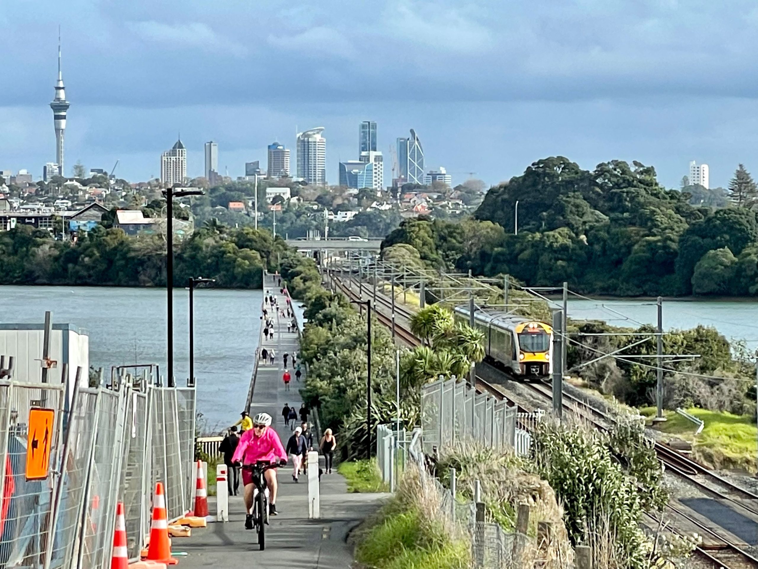
The freshly completed GI2TD Section 2 is 2.65km long, and New Lynn to Avondale is 2.9km. Together, these paths contribute to a 23km route across the isthmus from New Lynn to Glen Innes that’s almost entirely free from traffic danger, as well as free from traffic jams. In other words, more of the city is now a little more accessible to more people in more ways – as well as somewhat safer, and potentially a lot greener.


The two paths, while distinct in look and feel, have a lot in common besides their length:
- Both were in the original 2015-2018 Urban Cycleways Programme kicked off by John Key’s government.
- Both have been a long time coming – but, better late than never!
- Both are funded by government (through the UCP), Auckland Transport, and the respective Local Boards (Whau & Ōrakei).
- Both create access to and between neighbourhoods along the route, and heal significant local severances (road, rail, ravine).
- Both follow and connect into the train network, making rail and riding more mutually visible, accessible, and interesting.
- Both include practical features that were championed by advocates and communities (with more to come).
- Both lend themselves to short everyday trips, regular long commutes, and leisurely adventures (“urban rail trails”).
- Both include a few key issues that need prompt fixes (in one case, significant safety risks).
- Both projects will benefit from other links that are on the horizon.
- And hopefully both have automated counters on them!
They’re also both examples of a certain approach to cycleway-building that may be about to go out of fashion as the predominant style. Long-range shared paths, which take advantage of existing rail and/or motorway corridors – but which also seem to go out of their way to not overly disturb existing roads; this has an impact on the budget (although the $/km and the BCR are still better than the average motorway).
To sum up: both paths represent very welcome progress towards our sustainable transport goals, and highlight the broader opportunities ahead. Like: more safe local connections to these handy new assets, for starters. And also, faster projects, greater value for money, and the all-ages access to everyday bike transport that can come from redeploying the rich resource right under our noses: our streets.
Because that’s how the mode-shift we’re after will really kick in, once the rubber of thousands of bicycle tyres hits the road.
As Ariana Grande might say: “Thank U, Next!”
Check out our quick overview of the paths below. Have you had a chance to ride or walk either of them yet? What do you think?
GI2TD Section 2/ Te Ara ki Uta ki Tai
There are some lovely photos from opening weekend. Check out this Facebook album by John McKillop, Twitter threads galore, and this official video from opening day.
What and where: 2.65km of completely off-road path between Ōrakei and St John’s Road. Section 2 of Te Ara ki Uta ki Tai (the path of land and sea) links into the Ōrakei boardwalk at the city end. At the eastern end, it joins the existing section towards Glen Innes station, completed back in 2016.
Best thing about it? It’s not just a brilliant use of greenspace, it’s also really green! There’s been heaps of tidying up and new planting, with “nearly 35,000 native plants being planted across the route, 13,000 of which were sourced by the local Ngāti Whatua Ōrākei iwi nursery.” The path itself is nice and wide (mostly 4m the whole way), with great views – including of trains, including Te Huia.
Th future of transport needs 2 b low carbon 2 avoid climate crisis… th opening of Te Ara ki Uta ki Tai this morning shows it’s here right now if we want it. Electric trains, e-scooters & people walking, talking along the beautiful Pourewa Valley… the serenity! @WakaKotahiAkNth pic.twitter.com/2LKMBxEZPB
— Peter McGlashan (@PeterMcGlashan) May 24, 2022
Who’s it for? This is a people’s path, an attraction in itself. On opening weekend, people of all ages were out scooting, jogging, biking, walking with dogs and pushchairs.

And, as one of our commenters pointed out on Friday, it’s not just for weekend leisure or long-distance commuters – it’s also a “transformational traffic-free link” across the Pourewa Valley for hundreds of schoolkids who can now bike, walk, or scoot directly across the valley to Selwyn College, rather than going the long way round in traffic. It also puts many residents within an easy 5-10 minute bike (or 10-20 minute walk) of the train, for a 10-minute train ride to the city.
It’s also quite well lit for night travel.

Engineering highlights: This was a challenging build through some tricky terrain. Highlights include a 700m-long raised boardwalk, and the big bridge over the railway line.


Handy links: The standout is the connection to John Rymer Place – a desire line to Selwyn College, it was not in the original scope and was fought for and won by the community. There are also connections at Harapaki Road, Tahapa Crescent, Mamaku Street and through Tahapa Reserve West.
What needs fixing? Some have noticed a shortage of rubbish bins along the path, which will be important given the popularity of the path for dogs. Better bike parking at the stations will also be helpful.
The latest project update says wayfinding signage will be installed by Auckland Transport before the end of the year, and that a short section between Purewa Road and Ōrakei Basin will be completed, also before the end of the year.
What’s next? Work will be getting underway shortly on Section 4 along Ngapipi Road to Tamaki Drive, which will complete the full 7km route from GI into the city.
There are also reportedly plans for a link to Gowing Drive – which would be transformational for the south side of the path, both for school trips across the valley and for local access to Meadowbank station.
And of course there are AT’s long-planned safe routes in Glen Innes, most recently reconsulted in January this year.

New Lynn to Avondale
Lots of pics and videos of the Queens Birthday Weekend opening out there – people do love a new bike path!
Bumped into a few friends on the newly opened Avondale to New Lynn bike path today… if you build it, they will show the heck up! pic.twitter.com/hgdngG568y
— Jolisa Gracewood (@nzdodo) June 4, 2022
What and where? 2.9km of largely off-road path from Avondale station to New Lynn station. It starts at the Blockhouse Bay Road overbridge, follows the railway past the station, then ducks through Chalmers Reserve and under the railway line. On the other side it borrows a bit of Kāinga Ora carpark and a stretch of St George’s Road, then resumes running along the railway to New Lynn station.
Best thing about it? While not as glamorous as its easterly cousin, this path does exactly what it says on the tin: it goes from New Lynn to Avondale. Along the way, it demonstrates a number of different ways to deliver bike infrastructure. The underpass provides welcome access across the railway line, in an area with lots of level crossings. And there’s plenty to see along the way, including new housing development, mint views across the racecourse to the Waitakere ranges, and cool moments of industrial chic.


Who’s it for? Based on opening weekend, everybody! People walking and biking to and from shopping, free-range kids exploring their neighbourhoods, locals out for fresh air, weekend bike adventurers. It’ll be interesting to see the uptake for regular trips to work and school, too.

Engineering highlights: 1) The bridges at each end. 2) The underpass below the railway line, which is positively Dutch. 3) And the modest but inspiring section along St George’s Road, a great glimpse of what’s possible on ordinary streets.


Handy links: Because the path crosses several roads, there are plenty of access points – although not all of them are via bike-friendly streets. There’s also a nice new purpose-built entry to the path at Arran Street with built-in seating. A good spot for a water fountain and/or bike repair station?
At the Avondale end, the path links directly to the Waterview Path, and thus into the wider bike network including the Northwestern Cycleway, and the Southwestern Cycleway as well as Te Auaunga along Oakley Creek.
At the New Lynn end, there’s a short section of shared path (footpath) up the far side of Rankin St and on Margan Ave, which leads to a short section of separated cycleway on Seabrook Ave past the primary school.
What needs fixing? This route has some frankly awful safety issues where it crosses roads along the way (just ask Twitter!). This thread of video clips shows the range of hazards. You really have to hope the safety audit is all over this glaring risk and there’s a plan to fix it, fast.
https://twitter.com/hhb442/status/1534104746763554816?s=20&t=Q9uIOxN2FysXHBblSAI3Ag
There are also some tight pinch points at Avondale station, where riders are asked to walk their bikes, and on the approach to New Lynn. And, as with any off-road path, the underpass and the section through the park – while reasonably well lit – may feel a bit isolated at night.


Wayfinding is still a bit unclear at both ends of the path. If you’re coming from the Waterview Path, hang a left on the Blockhouse Bay Road overbridge to find the entrance. And at the New Lynn end, the desire line points you towards a footpath, but look for the designated path along the alley on the south side of the railway line (alongside Tyrepower).
What’s next? Logically, the St George’s Road section should continue directly to the Avondale town centre – as indicated on AT’s plan for more local links. We can also look forward to Te Whau Pathway along the Whau River (the wiggly purple line on the map below). And there’s promise of more links around New Lynn, as part of the Mayor’s climate action package.


 Processing...
Please explain to me how building 2.9Km of path for 44 million dollars!! is in anyway a sucess?
Sure, it’s less than a motorway but it does not go as far as a motorway or carry as much traffic as a motorway so the comparism is meaningless.
We cannot afford to build a network of paths at that per km cost.
That path existing was also used by AT as a reason to no build bike infrastructure on Ash Rata street.
Every transport investment that has to fight against the dominant roading network will cost a lot more. I’ve seen plenty of paths die on the table because the land acquisition was going to be too hard. Very very rarely the case for roading.
Does anyone remember how expensive the route through Grafton Gully was? Me neither. Now a massive success.
Also, no one ever gives a damn about how much it cost once it opens. Enjoy it.
Most of the land was already owned by either Auckland City or Auckland Transport.
None of the bridges were challenging.
“Also, no one ever gives a damn about how much it cost once it opens.”
Well, they should – where has it all gone? Additionally at that per Km rate you are going to have issues getting any more built.
The most expensive part in the New Lynn path was the rail underpass. You’d have to ask Dempsey Wood why.
The bridge parallel to the rail line was tricky due to both the live rail line and the overhead high voltage lines for craning anything.
Every new part of the transport network is going to get astoundingly expensive. From experience there are plenty of contractors now just passing on some major jobs. Both Kiwirail and NZTA are running out of money very fast and will kill off major jobs and instead offer up tiny packages.
We’re going to look back on SH18+Busway and Panmure-Pakuranga-Botany as the last big PT capex for a very long time.
Enjoy the ones we’ve managed to save.
These paths cost about $15 million per km. The opportunity cost is the issue. AT can protect bike lanes for 500k per km, so they can probably build them for about that cost.
These paths represent investment 30km of on road protected bike infrastructure per km. Imagine what Auckland would look like if we had 180 km of protected bike lanes?
Actually GI2TD section 2 cost at least $55 million or over $20 million per kilometre.
The opportunity cost problem is from spending money on new roads, and on widening roads when reallocation is possible.
Not from these paths.
To give you an idea of the scale, just looking at the projects in the RLTP that I know enough about to classify, I have identified programmes where:
– the entire budget should be reprioritised to other programmes. This would free up $4 billion!
– the nature of the programme should be changed to enable vehicle travel reductions and mode shift – this would put over $11 billion to better use.
That is where the changes have to happen. There is nothing to be gained from criticising the choice to build off road paths. We need them as well as the on road paths.
Heidi. Yes sure more should be invested from else where. But these paths are absolutely money sinks that are being used to protect car space.
NL2A was literally used as reason to not build on road infrastructure on Ash Rata.
The off road paths need feeder networks, we are not getting them or their scope is wound right down to token.
Jak, much of AT’s programme is about protecting car space. You’re falling for a trap by criticising these off-road paths instead of keeping the criticism firmly on the projects designed to ease traffic flow. Look at the numbers – $15 billion is just the start. There is money available for these offroad paths, and for the learning curve required.
Heidi. It’s not a trap, it was what AT does and says. This path was used as a reason to not make Ash Rata safe.
People live on streets and roads, that is where the bike space is desperately needed. Getting that short trip mode change, should be the low hanging fruit, these paths don’t let many people do that.
The later development of the city is framed along arterial roads, that where people soon enough need to ride.
What we will get instead is Te Whau path, building a bridge across the Whau river, which infuriatingly actually is is duplicating the NL2A.
A hundred million more dollars will be needed for that path, meanwhile, there will zero connection made between New Lynn and Henderson, (where you actually need multiple bike lanes) .
And we need both! We need a dense network, and we need both off road and on road paths.
If AT had been responsibly persistent in calling for legislation to allow parking levies, and had been charging for parking spaces all over the city, including on street and at stations, there’d be money for many off road paths every year, as well as other improvements all over the city, even at these bloated prices.
Heidi. We are only getting these mega expensive paths that avoid the large population areas tho.
AT is using them as way to avoid rocking the boat. The New Lynn to Henderson connection in ATs Henderson plans, involves use of Te Whau path. Great Northe Road and West Coast road remain as car land, while infill housing happens as fast as anywhere.
I am pretty sure the New Lynn bike network as part of the mayors, climate package, just got the chop. The “shovel ready” two years ago massively more expensive Te Whau path, is still go.
You got a spare 2.7 Billion?
City Rail Link now costs approximately $1.5 million per metre or $1.5 billion per kilometer.
But sure, keep comparing apples with chainsaws.
Ad.
This is surface bike infrastructure, to surface bike infrastructure. Its absolutely valid to compare them.
NL2A has a significant portion on the side to the road. A real bummer they did not bother to extend this the length of St Georges road so that path is more accessible. But free on street car parking is apparently incredibly important.
I actually don’t think it is that bad, its the cycling equivalent of a motorway to get people longer distances. Sometimes the harder sections of a network do have a high per km cost but are still worthwhile due the the connectivity they create. The thing that is now missing is the much cheaper connections to that “cycling motorway”. Most of these should be just the cost of some signs, paint and separators (and the removal of free car parking). Without doing those connections I agree it is a waste of money, just like building a motorway in a city that has no roads.
“I actually don’t think it is that bad, its the cycling equivalent of a motorway to get people longer distances. “
These shared paths are not that tho. They don’t have feeder networks, one has to cross 4 roads (without priority) in 2.9 km and the designers are specifically worried about people on bikes going to fast, so design them them for lower speeds.
The only way they are like bike motorways is cost and construction time.
“cycling motorway”.
It’s not even that. It connects nowhere that does not already have excellent public transport connections to New Lynn.
It’s full of bottlenecks that will become very apparent if traffic increases. (And if it doesn’t why build it in the first place). The end of the Avondale platform has 4 traffic flows jammed together. As pointed out elsewhere the road crossings are very challenging for groups of riders.
It’s like a “cycling motorway”. built on the cheap without it actually being cheap.
You are over looking the purpose of these paths. Just because it goes from a train station to a train station is main purpose is to allow people who live in between these stations to walk, scoot or cycle to the station to then travel further. This part of the path is also a missing connection to the wider network.
I would overlook all of that to avoid using the car and not cycling on a main road.
Happy to see if the cycle-counter suggests there are others who feel the same way.
Surely the problem areas can be sorted out over time and as usage increases, particularly the road crossings.
Are you saying we don’t need a decent connection from New Lynn to the existing cycleway into the city, or that you think there was a better route option?
Are you saying we don’t need a decent connection from New Lynn to the existing cycleway into the city,”
Is there any evidence to suggest that such a traffic flow would exist to take advantage of such a connection?
Pre-Covid the trains from New Lynn were full and the busses had to leave people at stops because of capacity limitations (it’s one of the reasons that we got the double decker’s out here)
I don’t see those commuters ditching public transport to purchase e-bikes to bike into the city. Except for dedicated riders New Lynn is just too far out.
There seems to be no demand to justify such a high expenditure.
Which brings me to my actual complaint. If they had spent $4.4 million on this experiment, then I would have no issues with it, but they spent ten times as much for no discernible reason. 44 Million will buy a lot of double decker busses (and a lot of bus lane) which will carry far more people than this alley ever will.
“There seems to be no demand”.
Is that what AT’s cycling team says? No.
Is that what international cycling experts say? No.
Is that what Aucklanders say? No.
Playing off public transport users’ needs against active transport users’ needs is out of date. We know the modes are complementary.
@Bob BAAL I regularly ebike ride from New Lynn to Fanshawe, along with many others, and this path will make that commute much nicer than riding on Wolverton and Blockhouse. I’ve found the trains too unreliable to make regular train trips.
A bonus of this new path is that I feel much more confident taking my kid on the back of my bike. Now I can get to Waterview / Zoo / MOTAT / Western Springs on a 99% car free route.
Comparison with a motorway is a bit strange: A shared path induces walking and micromobility trips. A motorway induces vehicle trips.
Thus, shared paths contribute to good public, social and environmental health; the net benefits per km are high. In contrast, motorways contribute to our problems: climate change, traffic danger, and poor public health, so at this stage of Auckland’s attempt to improve our transport system, the net costs per km are high.
The construction costs per km even for off road paths will come down when we have a steady programme of work and the decisions don’t have to skirt around minimising the effects on drivers. The construction costs per km for on road lanes will come down even further for the same reasons. To repair the biking networks after decades of decisions that have decimated people’s freedom to move without a car, we need both types.
Yes but they didn’t waste real money on these things. The used a different sort of currency called ‘other people’s money’ which according to AT is practically worthless.
$ 44 million is a fortune to me. But for people in Te Whau Ward, it’s about $ 550 each.
“And there’s promise of more links around New Lynn, as part of the Mayor’s climate action package.”
Well they talked about that in consultation sure, but the report released on 1/6/2022 made zero mention of New Lynn or of a bike network. So that’s not happening.
Its the typical Auckland solution of trying to spend “fairly” to provide a small amount of almost useless infrastructure for everybody and nobody.
Why not choose an area nearer the CBD where it will definitely be used and completely transform it with walking, cycling, PT and high density? Spend the money on something transformational instead of something mediocre. Then other areas may say “hey we want that too” instead of “look at the empty cycle lane to nowhere in the middle of suburbia that cost us $1 billion”.
I am not sure why people think connecting up train stations with bike/walking lanes is a good idea. They are already connected by busses and trains! If you want to get from New Lynn to Avondale would you not take the train?
I live in Avondale – I have walked it. One end is basically in the middle of nowhere. I took a bus to get to that end and then walked to New Lynn.
There are no obvious traffic flows that will use this. It seems to have been built as “build and they will come” philosophy.
Evidence, I guess, Bob. Walking and cycling to the train station works.
“I am not sure why people think connecting up train stations with bike/walking lanes is a good idea. They are already connected by busses and trains! If you want to get from New Lynn to Avondale would you not take the train?”
I wonder if a path that passes two stations will make it easier to get to the stations?
Buses are unreliable, uncomfortable, full of germs, and still costly.
Cycling is free and now after over a decade of waiting I have the option to leave the car behind, and avoid unreliable public transport, and cycle commute to town.
This is indeed my part of the world.
You need to tell the Dutch. They do it all the time.
Do we really need to play “my part of Auckland”?
The amount of infill housing in West Auckland is insane, there bike infrastructure black hole.
Jak I am not trying to play “my part of Auckland” at all. Of course it would be great if they chose my area but I doubt they would. But can they make the decision based on what will make the biggest transformation instead of “we don’t currently have much in xyz so lets put it there”. Personally I think the best place to start is closer to the centre but I am happy for other sensible places such as New Lynn due to connectivity to this new path.
Like I say we keep trying to build an entire mediocre city where everyone has some access to bad PT or the odd cycle lane or some pockets of density, instead of just picking some places and making them really good so people don’t have to move overseas to get be able to live in a proper city. At the moment the only choice in Auckland is suburbia, and there doesn’t seem to be any real plans to change that other than to make suburbia a bit better, but without the density or amenities to actually make it work properly.
The actual solution, is building not building these bloated paths and instead building 30 times as much on road bike infrastructure. But that requires AT to deal with people who say “what about my free parking”.
Imagined how much better it would had 180 km of bike infrastructure just been built, rather than 6?
Isn’t that like saying they could build 180km of bus lanes or 6km of train line? Yes building the bus lanes would give PT to everybody, but it would be sucky buses that take ages to get anywhere (I know this because I live near a “frequent” bus route that somehow takes 40 minutes to travel 10km at 15km/h). And the further from the city centre you go, the emptier those buses become.
Really we need a bit of both IMO.
“Isn’t that like saying they could build 180km of bus lanes or 6km of train line?”
No it’s like saying you can build 180 km of rail lines on the surface vs 6 km in tunnels.
Also, buses are fucking awesome. Are you a carist?
“Are you a carist” – I’d rather not have a car, I loved living in other cities where I didn’t need to. I use the bus when I have time and it goes where I want to go, but despite living near both a North/South and and East/West frequent route, they are just too slow to be of any real use if you have a busy life. The city end is particularly problematic on buses, it is a longish walk (particularly with kids) or a very slow transfer if I want to get to Quay Street or Wynyard Quarter (I never want to go to midtown where my bus terminates). All up from my house to Quay street is 3x longer by bus than car. Now if we had some rail in tunnels it would be a whole different story.
If you don’t want a car then sell it. You can absolutely be carless in Auckland.
Thankfully AT are more far more embracing of PT than bike stuff. The mayors frequent bus lines are set to service 90% of homes, with a stop within 500 hundred meters. 7 to 7 sub 15 minute waits. Hilariously, my carless household Is one of the 10%.
The rail tunnel is a decade or more away.
Yeah it would be nice if you could just take the bus to whatever place in the city but currently you would be a fool to try this as a casual PT user. You have no idea where the stops are this time. You have no idea where you can make the connection you need today because this or that bus stop is closed. Route planners tend to tell you where it was last month. You’ll get stranded every single time.
Case in point, what are they building on Lower Albert Street that takes 5 months? This is the sort of disruption that would be kept to a minimum in a city where PT is considered a serious way to get around.
You can’t blame people for playing the hand they have been dealt.
Roland. As an extreme PT user, I am always amazed by how bad other peoples experience are with Auckland PT. I have had minor unexpected delays twice this year, I must be incredibly lucky.
I am not talking about delays (car drivers get those all the time too). I am talking about other surprises, like having to walk the full length of Fanshawe Street because for some reason today the bus stops on that road are all weird and cancelled.
And no you’re not lucky, you just got used to it.
These huge bike infra projects may be less likely in the future but I would still like to see sea path completed and joined all the way up to constellation. And a bridge lane of course but that’s the reallocation style that we’ll need to ramp up.
The caption “The 700m boardwalk through Pourewa Valley. Photo: George Weeks” is wrong. This photo shows the much shorter boardwalk section through part of Tahapa Reserve East, not the Pourewa Valley.
Many thanks. Edited.
Meanwhile, AT explicitly puts safe cycling in the too hard basket at Hill Road, Manurewa, while making room for vehicle turning lanes and flatly stating the priority of heavy vehicle volumes.
‘Currently AT does not have plans to install cycle lanes along Hill Road. The strategic cycle route in the area is along Alfriston Road. Where possible we would encourage cyclists to use Alfriston Road rather than Hill Road as a commuting route as it is safer with clear lines of sight and dedicated cycling facilities.’
(https://at.govt.nz/about-us/have-your-say/south-auckland-consultations/hill-road-and-claude-road-manurewa-intersection-improvements/)
Are there any local history buffs who can explain the decision to shoehorn the half baked motorway access onto twisty Hill Road, rather than install full access at the aptly described clear, straight Alfriston Road ?
I used to live on Hill Rd but not before the motorway was put in! I suspect it was just for cost reasons, not that busy out that far and the conk in the motorway is where Alfriston Rd is.
Having riden both anyone else have the uncomfortable feels that the rich side of town sure did done got the brand new Mercedes grade path and the ol’ west a banged together panel beaten re-tread grade one?
Why, the both cost pretty much the same?
If there is anything to be dark about it’s they East is getting feeder network. New Lynn is not.
Ride them both; you’ll see the diff.
New Lynn is indeed a feeder network. It connects to the Portage Road cycleway which enables Green Bay and Titirangi people to cycle to New Lynn.
What about West of New Lynn, you know that area that’s moving massive infill housing, also fewer golf courses. That is right, that area (which would include Titirangi), got shafted by AT using this path to not build their planned bike Infrastructure along Ash Rata, the far more direct useful corridor.
Trying to put a cycleway up Ash Street was never going to be safe. Don’t kid yourself.
The other cycleway feeder into New Lynn is Seabrook Ave, which is indeed where a lot of the new housing density is going.
Anyone relying on the Te Whau Pathway is fooling themselves. They woefully underpriced it, and even the first two sections have stalled because they failed to price well. Te Whau a project on life support and will exist only in someone’s fanciful AMP.
Seabrook road has nothing on the infill along the rail corridor tho.
Ash Rata having a bike lane part of ATs plans (as above) Because of where it is, people are going to bike that road, infrastructure is still needed there.
ATs planned connection between two Henderson and New Lynn, is using Te Whau. The paths costing a fortune, taking an age to be built are minor compared to the issue, tht many people will need to use arterial roads to access them.
Portage road cycleway? You mean the door zone paint past all the car workshops? That sucks to ride on most of the way.
I’d like to see the shared path past the rugby club extended.
Chris W – it doesn’t look as if the Portage Rd section is part of the existing cycle lanes due to get protection added as part of this https://at.govt.nz/projects-roadworks/minor-cycling-and-micro-mobility-programme/ but it should be. Te Whau Pathway will extend it to Green Bay. And according to that list I linked Clarke St will also be getting protection added to existing lane.
There is expensive housing at the Kohi end but there is some low-income housing down by Meadowbank Station too. The path is likely to be used by people going between the latter area and Selwyn College.
The chalmers reserve playground was knocked down as part of the build but it is scheduled to be replaced, hopefully with something rather nice
It is a start.
It is good to see it happening.
I wish they planned for a scenario 10 years into the future. I am sure there will be lot more e-bikes, bikes once the whole link is completed and my main concern is that it will be too narrow in some place if lot more cyclist will be using it.
At least it is a step in the right direction
I don’t think rubbish bins should be provided on GI2TD. Your rubbish is your responsibility – as is your dog’s poo. Some people litter whether there is a bin handy or not. Bins have to be emptied regularly and tend to attract trash around them as well as in them.
In Tokyo, for example, bins are not provided. People take their rubbish home or, if they buy something from a convenience store, return the packaging there.
It’s about people changing their behaviour for the greater good. Driving less to help slow climate change might be beyond us. Hopefully, looking after our own rubbish isn’t.
Speaking of dogs and Tokyo, another cultural habit we can borrow from them is cleaning up after dogs: Japanese dog owners will typically have a water bottle with them when walking their dogs, to rinse down the area where their dog has toiletted (#1 or #2)
That looks like an epic loop, can’t wait to ride it next time I’m in Auckland.
It is! On the opening day last weekend I combined them with the Northwestern motorway path, the South-Western motorway path, Waikaraka Cycleway, and the Tamaki rive path, for a ride around the whole isthmus, largely off-road.
“I wonder if a path that passes two stations will make it easier to get to the stations?”
For those making similar comments like this, it looks superficially as this would be a good idea. However, get out google maps and look at the natural catchment areas for the stations and bus stops.
You will see that they have nothing in common with this path. For most people wanting to use the bus/trains the existing paths already provide adequate access that this path cannot assist with.
It basically runs parallel to existing flows, the bus routes and the train route.
Except for a small number of locations, it would take longer to access the stations/stops via this path than use existing options.
“Better travel options” is one of four strategic objectives in the governmental policy statement on transport.
“The primary focus of this priority is to improve people’s transport choices in getting to places where they live, work and play, and to make sure our cities and towns have transport networks that are fit for purpose and fit for the future.”
It doesn’t say, “we’re going to provide one sustainable mode only, on each route”. It’s sweet of you to assume people will want to use one particular mode, but it’s not a particularly useful reckon. People want choice.
“People want choice.”
I have no problem with that but its sweet that you think people want as part of that choice completely unnecessary replication of existing satisfactory options while staving other options of funds as a result of that duplication.
At no point were the people of Avondale or New Lynn consulted on this except in the general catch all of “who want better transport options”
You still haven’t said anything to justify spending 44 Million on this boondoggle.
““Better travel options” is one of four strategic objectives in the governmental policy statement on transport.” Fine now show how this wrong path in the wrong place contributes to this objective.
““The primary …purpose and fit for the future.”
Fine but how does this 44 million pork barrel satisfy this requirement.
“It doesn’t say, “we’re going to provide one sustainable mode only, on each route”. Strawman nobody said that – the route of this path already has two sustainable options that the people of Avondale and New Lynn have supported in large numbers.
What next a canal for even more illusion of people’s choice?
Bob, I think we all agree that as the post mentions, these off-road solutions come at a premium. And that there’s huge potential for more links in the area. And that they’ll be much more affordable to deliver. And even more compelling, now that this path exists.
But what’s the “existing satisfactory option” for the free range kids in the photo of Chalmers Reserve, or the family with the double-stroller walking to the train station? Not all trips are A to B along a train line or a motorway.
A canal does sound cool though. Rising seas might take care of that one for us.
You’re asking for justification for spending money on the most neglected mode, after giving no justification for your outrageous reckons that the path is in the wrong place, that it provides an unnecessary replication of options, or that there is no demand.
We all agree AT need to bring their costs down, but there’s no excuse for claiming PT and active modes are in competition for funding. We need both.
They were not satisfactory existing options. Tiverton-Wolverton is a heinous risk for cycling.
Yes New Lynn people were extensively consulted. Not sure where you were, but the consultation went on for a long time.
It is the right path in the right place for many in the west who have not had a safe way to connect to Avondale-SH16 and SH16-Downtown which is the new way to commute now.
There are many who will never use public transport again after COVID and its future variants. Also train reliability won’t improve until at least 2024.
Plus of course taking the train has a cash price, cycling does not. So as a Titirangi citizen I will now certainly be swapping modes to commute to town.
I have been waiting for this cycling facility since the New Lynn station was completed in 2009.
I have walked the Eastern path both ways its fabulous I will venture out west to view the other one soon. Let’s celebrate what has being achieved.
@Curious Cat (sorry my reply button is only working on alternative posts.
“But what’s the “existing satisfactory option” for the free range kids in the photo of Chalmers Reserve’
I am confused what makes you think there were access issues to Chalmers reserve?
There are/were about 6 safe access paths to the reserve that free range kids used before this “improvement’ and I expect the kids to continue using them after this. This change does not in any way make Chalmers more accessible. There is however a problem in that they have installed a very unsafe crossing at one end that I would not let any child cross without adult supervision. Certainly, I would be very worried about free range kids crossing that path alone. Even installing signals at that crossing would have problems.
“the family with the double-stroller walking to the train station?”
They are not going to the train station – they don’t seem to be going anywhere!
If they wanted to access the train station, they would turn left where the photographer is, and they would have flat access to the Swanson bound platform.
If they wanted the Britomart platform they would again turn left and have flat access across to the ped crossing to that platform.
If they were going to Avondale town center, then they would turn left and cross the tracks at the level crossing. If they wanted the shops at the end, then they should have turned left crossed the tracks then turned right and gone that way(all flat).
The only place that leads to is then end of the path which dumps you at a road junction. If they wanted to go there turning right, then up the hill would actually have been easier. I cannot think of any reason to go that way other than to get to the end of the path. They could have used the platform for flat access for a stroller as well.
“Not all trips are A to B along a train line or a motorway.” I am not suggesting that they are, I am suggesting the right path in the right place is what they want.
There are some real Negative Nigels or Downer Daves in the comment thread today!
…My experience outside of the GA bubble is that many friends are keen as to test these routes – the connected paths unlock their ability to explore Auckland by bike and scooter from closer to their homes. Both for local rides with the kids, and for commuting or travelling further afield across Auckland. The bonus of linking to the train network is that with young kids you can tailor the length of the trip to their energy levels and catch the train home. That’s the benefit for anyone, young or old, and not currently possible with the bus system. Bring on more paths (and improve the feeders for these ones)!
Well said, Lisa with explaining why the train connections are so useful! (tho you missed Belligerent Bobs 😉 )
As to costs, I am aware that these trails are expensive, but every job near a railway line has significant H&S compliance costs. Also all the cycle super highways require the implementation of lighting, drainage, planting plans etc. Removing car parks and leaving the street design alone (curbs, lights, drains etc) like St Luks Rd, must be dirt cheap compared to these new trails. I believe we need both. These trails are aspirational and as others have said will get people out in the w/e exploring. No-one is going to make a special trip to ride St Lukes Rd of course. Once these riders have tried these new trails they may see that they can make them part of their daily trips (commuting, school, running errands, socializing etc). These new cyclists will start pushing for more safe community cycling.
I note also that one of the criticisms of the New Lynn to Avondale is that it does not go far enough West. Those who want to ride the urban rail trail can get from New Lynn almost all the way to GI with only a short section on-road. This is too far for the trip to school or work for all but the ardent cyclists, but a good effort for an afternoon outing (say).
On protected trails from New Lynn you can now take rides to:
1. Sandringham, Mt Roskill, Onehunga, Mangere Bridge and on to Favona/Otahuhu,
2. Penrose
3. Most of the way to the airport,
4. Ambury Farm,
5. The CBD and Tamaki Drive,
6. Westgate too if you want to take the scenic route.
7. etc (but not the North Shore sadly)
Its all part of the network effect. The bigger the network, the more important these key sections become.
“Those who want to ride the urban rail trail can get from New Lynn almost all the way to GI with only a short section on-road”
Yea but that road is Great North Road, that not kind road to ride a bike along. If you deviate, you quadruple the time to New Lynn. New Lynn it’s self is a shit show for biking, and there what 4 maybe 5 sets of lights to get path from the west. It’s such a fart around that it’s probably quicker to bike Ash Rata….
Oh then the 2.9 km path crosses traffic 4 times.
Agree. The design had to be completely altered in 2014-5because in part Kiwirail simply didn’t want more of it near their corridor and needed a greater ‘hygiene width’.
Also land acquisition costs were a factor.
Negative? Guilty as charged.
One of these paths killed a far more useful connection and further postponed any road space being given to bikes. All for 30 times plus the cost per Km of ATs remedial work (making big gutters protected lanes).
With the amount that these two paths cost, could have transformed the city with 180 km of new protected bike lanes which could have been built in less time, instead, we get almost 6 km of shared path away from major population centres mostly.
@ad
“Yes New Lynn people were extensively consulted.” Yes I was there – please remind me when we were told that this was. 44 Million Dollar project? Also, when was the case made that this would bring benefits justifying that investment?
It was not just me – one of our local councillors wrote a long article in a local paper about 6 months ago bemoaning how much time they had put into these consultations only to have their input comprehensively ignored (sorry don’t remember her name, neither do I remember her points)
She made the accusation that the consultation was just window dressing.
Too much trolling going on. Ash-Rata is difficult. GNR needs perhaps more.
Now these paths are open, the missing connections have a good business case to build on them.
Avondale -New Lynn is part of a Waitakere City Council idea to get a cycle spine along the railway. This shows the engineering isn’t as easy as the idea, with a few things still to fix up.
GI2T – this is the finished Eastern Motorway. It’s cheaper, less destructive of natural environment, more enjoyable and now provides for feet, bikes, trains and birds’ wings – just not cars and trucks. And I think a heck of a lot cheaper than a motorway.
“Avondale-New Lynn is part of a Waitakere City Council idea to get a cycle spine along the railway. This shows the engineering isn’t as easy as the idea..”
The agency politics is the problem, not the engineering.
Is anywhere in the Auckland region getting a strictly local cycling network focused around its schools and transport nodes?
Too much fixation with long-distance and commuting routes to my eyes.
Substituting school driving trips can generate mode shift relatively simply. Then use that place as a demonstration for elsewhere about what is possible. Rinse, fund, and repeat.
Side issue: weren’t the eastern suburbs locals pushing for a station in between GI and Meadowbank?
Near where Kohimarama Rd/SH9 crosses the rail line (about smack bang in the middle of the two stations), the reserve previously cut off a lot of walk up catchment but the path would presumably change that dramatically? Plus with a bit of thought, major roads coming from/to Selwyn college, St Heliers and Glendowie, as well as the southern Meadowbank streets and St Johns Park could deliver a lot of users by bus and additional cycleways.
Extra stations add time of course, but its the only obvious addition on this line and it could move a lot of people out of cars and onto trains
Would be nice – but pretty close to the other ones and would be expensive as deep, need lifts etc. The trains run pretty fast through here so with slowing and extra stop not sure it would be worth it. Better to drive some more active modes via the path to the other stations.
Perhaps would be worth it if you take out Orakei, where the catchment looks pretty limited.
$15m/km or $20m/km…. right.
Now how many km of cycle lane could that much money protect with concrete tim tams?
Looks like a gold plated solution to me, while other areas of Auckland have absolutely nothing in the way of cycling infrastructure.
Next time AT has $55m to spend, instead of building less than 3km of paths, how about they provide some protection for cyclists in places like around the Royal Oak roundabout?