We live in an era of significant change to Auckland’s transport system – although not as much as it should be. While daily frustrations about a lack of progress are never-ending, when we zoom out it’s clear that amazing progress has been made over the past 20 years to improve public transport and (more recently) cycling. We still have a very long way to go, but it’s important to recognise that we have also come a long way since the 1990s. We are living through a transport revolution of sorts, where Auckland transforms from a highly car dependent overgrown town into a proper multi-modal metropolitan city.
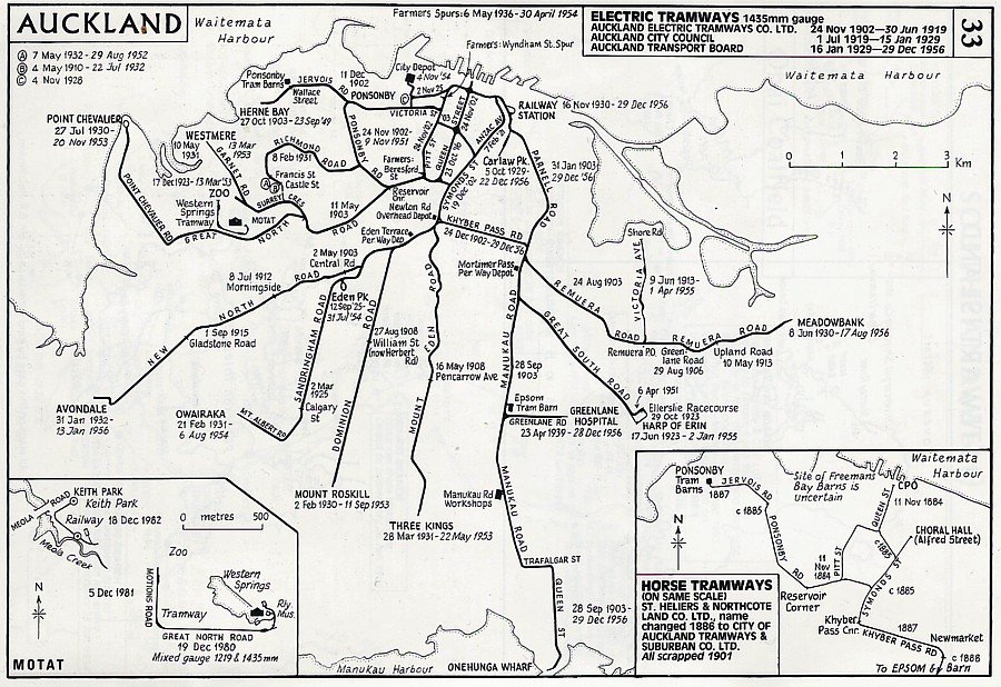
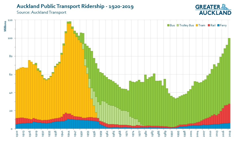
This is not Auckland’s first transport revolution. It is also a much more gentle, people-led revolution compared to our previous one – which mainly occurred over a 20 year period after the end of World War II. Back then Auckland had an extensive tram network and one of the highest levels of public transport use in the world:
In the late 1940s the Ministry of Works produced a reasonably balanced transport vision for Auckland – a mixture of new motorways around the edge of the city and railway lines to serve the centre. This is shown in the map below, which notably includes the Morningside Deviation, a precursor to the City Rail Link:

The recently completed Western Ring Route was, in this plan, the main way through Auckland – with the focus being on having highways largely bypass the city centre, which would instead be served by the rail network including a new underground link that we are just getting around to building now.
However, not too many years later this plan was replaced by probably the most influential planning document ever created in Auckland – the notorious 1955 Master Transportation Plan. This plan had a pretty complex gestation, but what’s probably the most important thing to note is how the shift from a multi-modal approach to transport planning to one that focused almost exclusively on roads was predominantly pushed by ‘behind the scenes’ officials and engineers, rather than by the public or the politicians they elect.

Source: https://research-repository.griffith.edu.au/bitstream/handle/10072/18502/49095_1.pdf
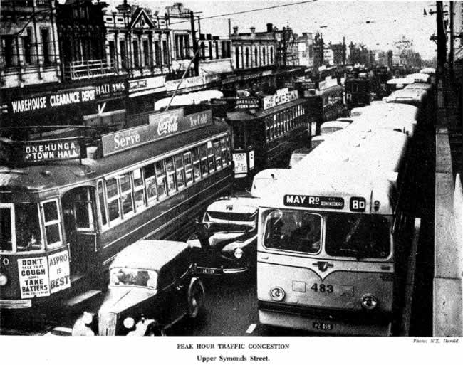
The 1955 Plan used imagery very effectively, to contrast congestion seemingly caused by Auckland’s tram system against the free-flowing motorways that US cities had started to build.

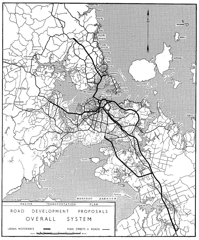
The roading network proposed in this Plan became the blueprint for many decades of motorways to come. This was largely based on the assumption that most future travel would be on the roads and that simply not enough people would use the rail network to justify investment in it. Of course this became a self-fulfilling prophecy as the rail system was left to decline for the next 50 years while a modern motorway network was built. It was the genesis of the ‘motorway noose’ that now surround’s Auckland’s city centre – which is also said to have been about encouraging enough people to use the Harbour Bridge to pay the tolls:

Fortunately the Dominion Road motorway (other than the New North Rd interchange and parts of Ian McKinnon Dr), the Eastern Motorway and the Quay Street elevated motorway were never built, but most of the rest of the motorway system proposed in this plan has ended up being built.
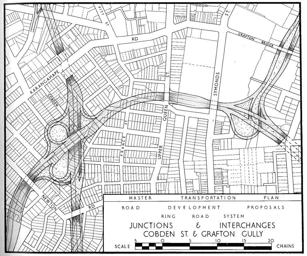
Many of the impacts from building these new motorways were laughably under-estimated by the plan. For example the property impacts of driving motorways through the inner suburbs have turned out to be quite a lot more severe than what was shown in these plans.
Perhaps unsurprisingly, the rail spur proposed as a cheaper option to the Morningside Deviation (basically the only rail investment proposed in the plan) was never built.

The map is a little bit tricky to read, but effectively the line would have extended in a spur from the old Auckland Railway Station, underneath Albert Park and then with an underground station beneath a bit of Albert Park with the main entrance being basically underneath where the Victoria Street carpark is now located.
Somewhat infamously, future mayor and rail advocate Sir Dove-Myer Robinson actually moved the resolution for the plan to be passed, which apparently haunted him for decades to come. After its approval, implementation commenced quickly and Auckland’s motorway network grew rapidly from the mid-1950s onwards. In fact, not too many years later another plan, prepared by the American firm De Leuw Cather, was prepared that included even more motorways:

Critically, De Leuw Cather produced a second report saying how essential it was to complement these road improvements with high quality rapid transit. In fact they made it really clear how important high quality rapid transit was to having a successful integrated transport system.
![]()
The system they proposed was quite extensive and would have seen the modernisation of Auckland’s rail network decades before it finally happened.
![]()
Again only the motorway parts of these plans were ever progressed during the second half of the 20th century. This led to an explosion of the use of private vehicles and correspondingly public transport use plummeted – aside from a period during the 1970s and 1980s when oil crises and rapid inflation pushed up fuel prices and people got back on the bus. Public transport use wouldn’t bottom out until the mid-1990s.
Now it’s unlikely that Auckland would have completely escaped the automobile age, especially during the late 20th century when petrol was cheap, roads were empty and climate change was barely thought of. But it does seem likely that Auckland could have had a less extreme transport revolution in the 1950s. Perhaps one where some of the tram routes were retained, like Melbourne and Toronto managed. Or one where rail networks were modernised, like happened in most Australian cities as well as even numerous American cities (Washington DC, Atlanta & San Francisco all built major transit systems). Perhaps Auckland could have routed its motorways away from the city – like was originally planned in the late 1940s.
Sadly none of that happened, which means that for all the progress we have made over the past decade or so, much has simply been ‘catching up’. Auckland’s previous transport revolution casts a long shadow on us all.

 Processing...
“behind the scenes officials and engineers” may have made the shift to roads, but what was the role of the National government in appointing them? Roading contractor, William Goosman, was Minister of Railways when most of those officials were appointed.
Goosman was also Minister of Works, and pushed for more use of contractors.
Cartoon of Stan Goosman awarding himself a “Roads Scholarship”
https://thumbnailer.digitalnz.org/?resize=664%3E&src=http%3A%2F%2Fndhadeliver.natlib.govt.nz%2FNLNZStreamGate%2Fget%3Fdps_pid%3DIE3712881
That final graph would be even more amazing to see with a graph of population on it. Massive growth in population presumably in the last 30 years, but what would explain that huge peak in 1945? Presumably not US Marines taking the tram?
Fuel rationing.
I think there is more going on than rationing. Fuel was rationed from 1939 to 1950 with a short break in 46 and 47. There were a lot of servicemen in Auckland throughout the war period and not just the US soldiers and marines. The navy base and airforce bases expanded their workforces quickly and the port was extremely busy. I think the influx of women into the workforce that occurred into offices and factories is also a big part of this story.
The peak isn’t so much about public transport as it is about economic activity. The depression might have technically ended in 1933 but the effects continued until the war.
It may well have been US Marines. My grandmother lived in Akepiro
Street (near the Dominion Road flyover) and 1942 to 1944 she had a
couple of US servicemen billeted with her. I don’t know what service
they were. I’m was told they called her ‘Mom’ .
St Heliers horse tramway? I’m kind of curious about this, anyone know any more? In any other city in the world, seaside villages and parks like St Heliers & Mission Bay would be served by trams from the city centre.
From Wikipedia (https://en.wikipedia.org/wiki/Saint_Heliers):
“The St. Heliers and Northcote Land Company built a 460m (1500 foot) piet at St. Heliers in 1882 before becoming insolvent. However, the tramway connection to Auckland was never realized.”
Source appears to be this book:
Elizabeth T. Jackson (1976). Delving Into The Past of Auckland’s Eastern Suburbs: Section 6 St. Heliers Bay. Auckland, N.Z.
Isle of Man. (ie the Manx people) still have a horse-drawn tramway in service. Great fuss the other year when they tried to withdraw it…
This history shows clearly that even decent plans can be derailed later on. That’s why we all have to keep applying pressure to keep things on track, even when they appear to be going in the right direction already.
The swathe of city destroyed by those motorways was so much wider than the map indicated, as you pointed out. And the motorway widenings and the turning of local roads into weapons grade-ugly roads that are little better than on ramps and off ramps is continuing still.
Is there any hope in sight that NZTA and AT are going to stop this?
Is a gentle, people-led revolution another way of saying a frustratingly slow revolution that takes the time of many people having to advocate, over and over, to see tiny incremental change? The war on children deserves a more radical halt, I believe.
And you must remember up until the 70’s you had to/or know someone that had overseas funds to buy a new car . And even buying a secondhand car you either had to have the full amount or at least a 20% deposit before you could get finance
I can remember a time in the 1970’s when a 50% deposit was required.
One way around that was to buy a car, like a Ford Escort van, available on
25% deposit. You picked it up, brand new, drove it around the block, and
brought it back to the car dealer. He fitted side windows and a bench rear seat. Bingo – you now have a station wagon !
In the early 70s my old man realised it was far cheaper for him to buy a car in England and ship it home as a personal possession (tax free), than it was to buy a car in NZ.
He brought home a brand new MGBGT in burnt orange (sick ride pops!) which he promptly sold for more than the sticker price in NZ, paid for his OE and put a deposit down on a house. (Second hand cars were actually more valuable than new, because they were easier to purchase and without waiting list).
We need a long term planning agency that does not derailed by the change of government.
Land use and transport go hand in hand and cannot be separated. Travel is simply the derived demand of the spatial land use patterns.
To have had efficient and effective public transport would have also required the land use zonings for new developments to support it. Hard to see in the land of 1/4 acre pavlova paradise.
If we are serious about getting an efficient, effective and integrated land use/transport system we need to:
i) disband the separate transport authorities (NTZA) and regional/council PT split responsibilities.
ii) Integrate the regional and district councils as unitary authorities responsible for all landuse/transport in their area
iii) Set NZTA to provide national infrastructure standards based on vision zero, & landuse/transport integration
iv) Consider what role Kāinga Ora can play in developing/enabling mixed income nodal developments around PT hubs and major stops.
v) Allow the unitary authorities to congestion charge
vi) Require the unitary authorities to provide comprehensive coverage PT systems (on-demand where fixed routes are not cost effective) for the poorer in society with low PT fares or welfare transfers to cover the transport costs.
Thanks for another good summary of a dark day in democracy, as well as transport planning. On top of all the other negatives the brazen misdirection of Auckland transport planning towards freeways caused, you can add operating subsidies. The old Auckland tram system covered its operating costs – it was not subsidised. Now AT has to subsidise rail and buses by hundreds of millions of dollars per year. So Auckland has spent a fortune on road capital projects that have also caused ratepayers to cover the shortfall of revenue on a public transport system that was starved of funds and passengers.
Interesting that in most cities where the general public got to decide (e.g. Melbourne and Zurich) trams were retained.
Yes true Sock Puppett, but the above graph highlights just how many potential passengers there were in a relatively small area. The number in that area must have increased substantially with infill housing. The challenge now is to induce those people to use public transport and to do it on a regular basis.
The other takeaway from that graph is the rapid speed at which ridership in the previous revolution increased, compared to the more recent revolution. How can AT recreate previous growth rates? I suspect the CRL and light rail will be major drivers, but what in the interim – price reductions?
Good question John. It would take some study to determine a full answer. However it is obvious a package of measures. Western cities did not only change from building transit to building freeways. We also built more spread-out housing, streets with poor footpaths and roads with few safe crossings. We need work on the destination end of land use as well as the housing stock. Toronto has a rule that major employment sites must be within a walkable distance of high frequency PT. Their plan refers to density of employment and residents near these nodes.Away from them density may be low. Shops near transit are also good to get people out of cars and using transit for non-work trips. See https://urbantoronto.ca/news/2017/04/densecity-part-1-where-toronto-builds-density-and-why
Great post. Good to have some positive ones even if hard to do sometimes.
Thanks for this post, Matt. It will be an excellent reference to bookmark alongside the series on Robbie’s transport ideas a year or so ago. Excellent research – top marks for this.