The Northwest Busway is one of Auckland’s most important upcoming transport projects. In April last year it was announced that the NZTA board had approved an investment case for the project and that more work would happen on design with the aim of getting designations for the busway, likely via the Fast Track process.
In November we got indicative designs for the project, giving us a first look at what was planned. Now that Fast Track process has been applied for, providing a lot more detail about what is proposed.
Benefits
The Northern Busway has been an amazing success for the North Shore, and most people will probably appreciate that something similar will be a fantastic addition to the Northwest, providing faster, more reliable public transport and giving people more realistic options for traveling around Auckland.
Below are some of the specific benefits that are highlighted in the Fast Track application for the NW busway:
- Bus travel times between Westgate Te Waiarohia station and Karanga-a-Hape station (delivered as part of the CRL project) in the city centre are expected to reduce to 22 minutes, saving up to 15 minutes compared to the existing Western Express (WX1) bus service. It would also make it very competitive to driving throughout much of the day.
Here’s a quick comparison chart I’ve made, using travel times based on Google Maps:
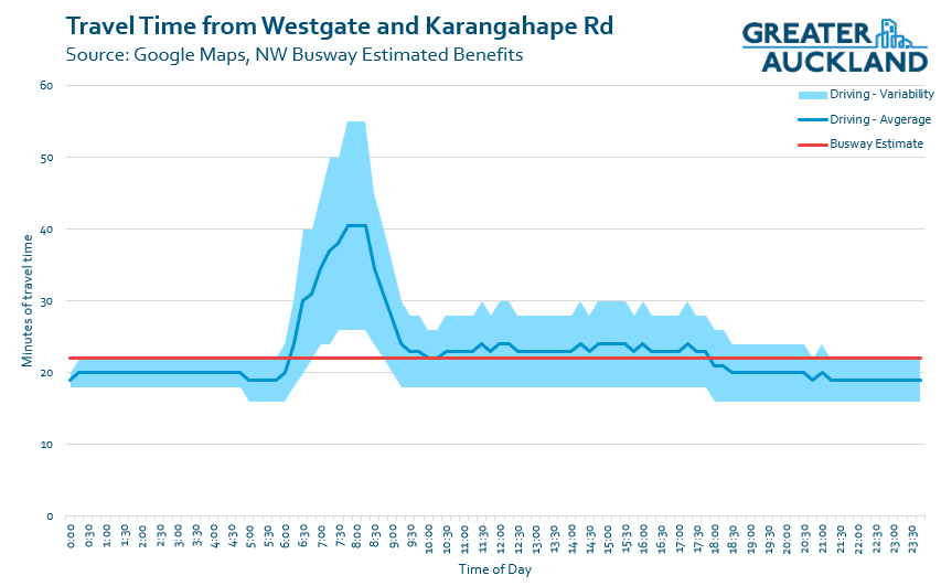
- It’s not just that buses will be faster – there will also be less variability in travel times compared to the current situation. The application suggests that currently travel-time variability is about 14 minutes in the morning peak, and 25.5 minutes in the evening peak. With the busway, this is expected to drop to 2-4 minutes across the day.
- The busway will enable higher frequency services to operate at consistent headways compared to the current WX1, and will be capable of moving 9,000 passengers an hour in the peak direction – that’s the theoretical capacity of four motorway lanes of general traffic.
- One interesting idea identified is the potential to integrate the NW busway with the existing Northern Busway corridor, including the through-running of bus services to enable a West-North rapid transit link.
- With the improvements, it is estimated that by 2051 there will be 5.4 million annual weekday boardings. Typically about 87% of PT trips happen on weekdays, so that would put total annual boardings just over 6 million.
- To put that in comparison: there are currently just over 2 million annual boardings on the WX1 and 11T/W services, and about 7.7 million on the Northern Busway. Prior to COVID the Northern Busway peaked at almost 8.7 million annual boardings.
- The new, better, purpose-built stations will enable faster and easier transfers between services. They will also have direct connections to the Northwest Shared Path, which will help to increase its catchment, plus there will be additional improvements to the path as part of the project. It’s good to see the proactive tying together of public and active transport.
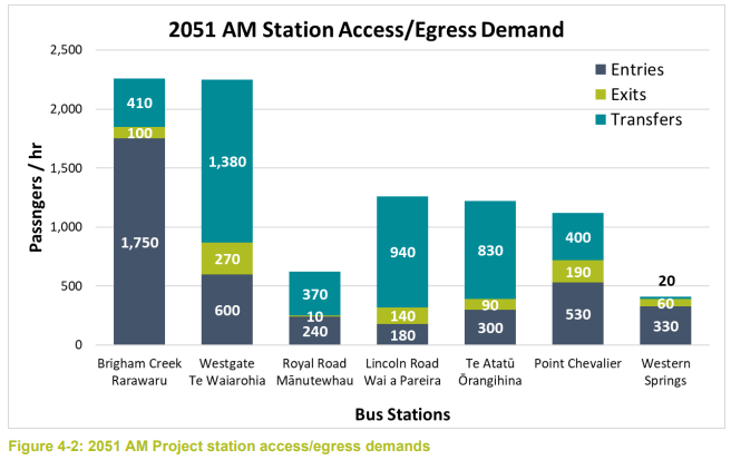
- On the topic of station access, their modelling suggests that most people will access the busway by transferring from another bus. The big exception is with Brigham Creek Rarawaru, as that will also have a park-and-ride facility.
The Indicative Design
We’ve already seen some images of the indicative design, and I’ve included some of those again below. Now we can also see a top-down view of what’s planned, which may help better explain what is being proposed.
The design images are split into two sections, east and west. I’ll start with the latter as that’s the first sections that are expected to get built.
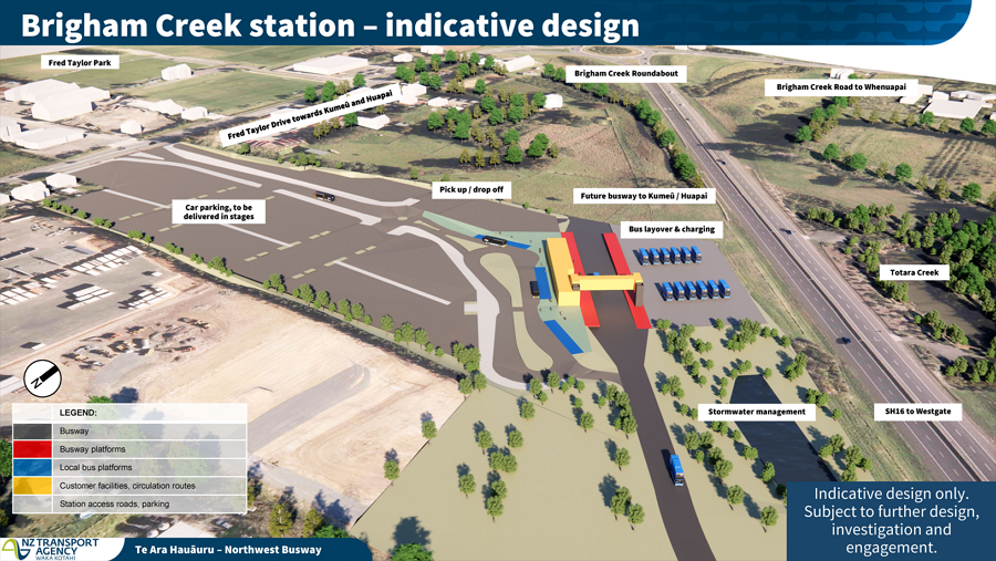
Brigham Creek Rarawaru Station
This is the only station along the busway that has park-and-ride included, as it is intended to serve the wider surrounding area. It is estimated to initially have 500 carparks. It is also designed to be able to be extended in the future.
As noted in our last post, they’ve put the “non-human” infrastructure – like stormwater ponds and bus layover/charging – between the busway and motorway to keep it out of the way.
The big omission here is why the NW shared path hasn’t been extended alongside the busway.
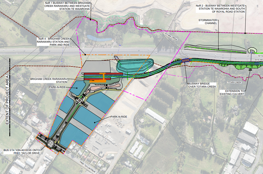
 Not far south of Brigham Creek, I do wonder if a short connection to the busway from Northside might be advantageous. There is a plan for Northside Dr to eventually extend across the motorway and to Trig Rd, and notably some of the bridge abutments and piers were built for this in advance.
When the bridge does eventually get built, a connection to the busway would allow either the existing 12 bus or a dedicated Upper Harbour Express service to use it to access the motorway interchange at Trig Rd, and run along it in much the same way as the 12 does between Greenhithe and Constellation Station.
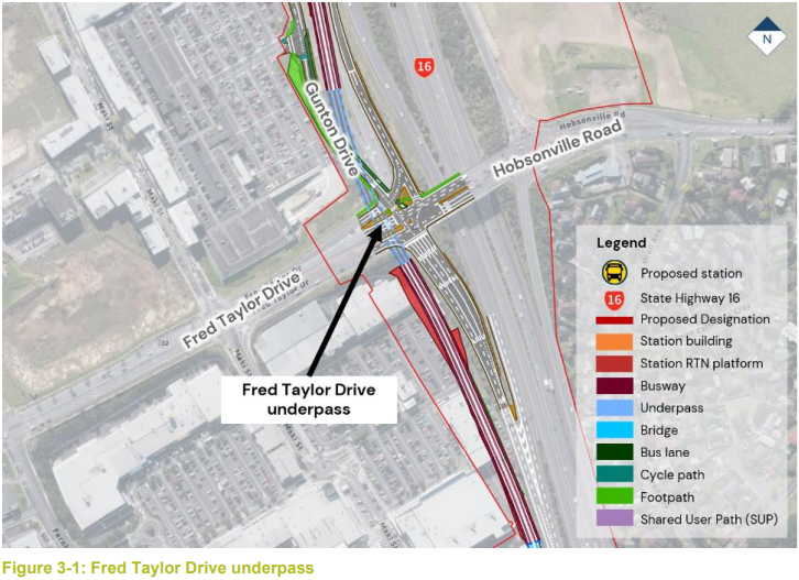
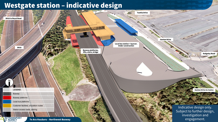
Westgate Te Waiarohia Station
The first half of the station – for local buses and a terminus for the WX1 – is already under construction, and the second half, which will create a proper busway station, would be built as part of the project.
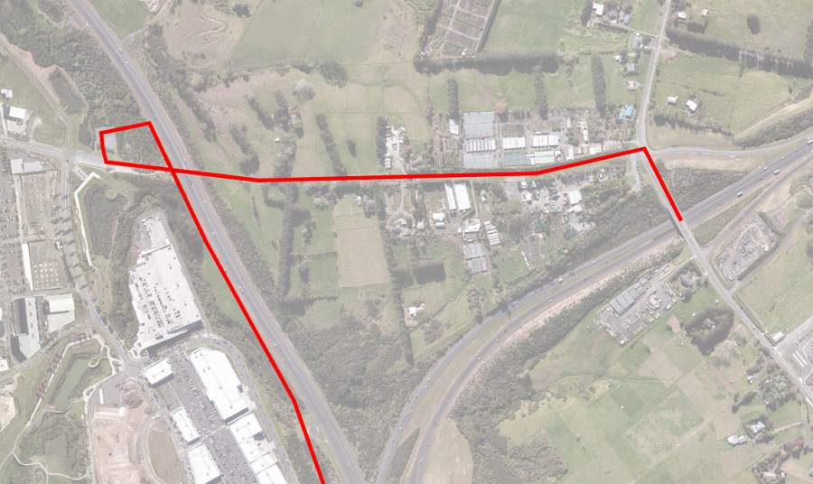
The busway is expected to pass under Fred Taylor Dr. The reports indicate that building this could take up to four years and require the removal of 244 carparks from the Westgate centre during construction – though clearly some carparks will go permanently.
Royal Rd Mānutewhau Station
Between Westgate and Royal Rd, the existing shared path will be shifted west to make way for the busway. When the path gets to Royal Rd it will also benefit from being able to pass under the road, eliminating quite a steep section up Makora Rd. Unfortunately, there will still be a need to cross the motorway off-ramp.
For the station itself, there is quite a significant water main attached to the existing bridge which needs to be moved to enable the underpass. That is a large part of why an additional bridge is proposed – it can be built off-line and the water main moved only once.
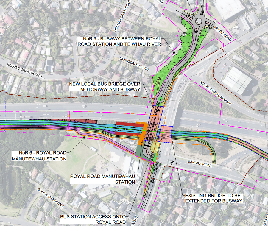
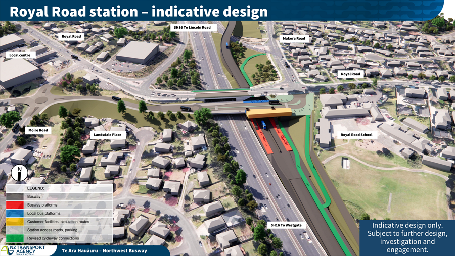
After passing Royal Rd, the busway moves to the west of the of the shared path – I’ve seen some concern expresed about the path being removed because it’s not highlighted on the images – it’s not being removed, there’s just little change to it other than to some of the access points.
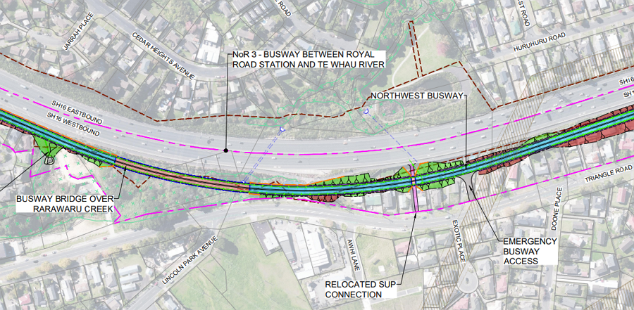
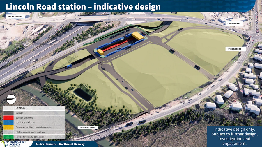
Lincoln Rd Wai o Pareira Station
The Lincoln Rd station will one of the most unique busway stations in Auckland. The busway will sit in a trench to enable it, shortly after passing under Lincoln Rd. Meanwhile local buses stops will be located above the station. This is essentially the same as how the New Lynn train station at works.
Like at Royal Rd, the cycleway will also make use of the underpass – removing the need to cross four sets of traffic lights at this busy interchange.
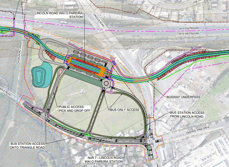
 It would be great if we could also think about expanding access in other ways. For example, a short section of boardwalk could help expand the active mode catchment of the station to the southwest, enabling people to access the station without using the often hostile Lincoln Rd.
 Such a connection could also eventually tie in to the potential greenways that are a response to the 2023 floods. The image below is just to the west of the image above.

As with between Royal Rd and Lincoln, the shared path will remain largely unchanged here, and will run between the motorway and busway.
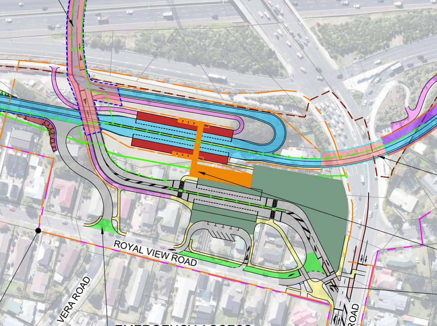
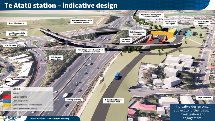
Te Atatū Ōrangihina Station
Te Atatū was the station that probably caused the most surprise and confusion when the previous images were released a few months ago. As with the other major roads, the busway will pass under Te Atatū Rd, but the unique feature here is a new bus and active mode bridge over the motorway and interchange.
This is intended to:
- Get busway buses to the onramp – there are no current plans for the busway to extend across the causeway, so this will enable buses to quickly access the bus shoulder lanes.
- Get local buses and people out of the motorway interchange.
On the southern side of Te Atatū Rd, the shared path will be realigned so it can pass under the bus off-ramp. They note this means it introduces “increased lengths of gradient over 5%” which would make walking and cycling a bit harder, and therefore it might have impact on use. The cycleway will continue to use the existing underpass to pass along beside the station.

Here’s a closer view of the Te Atatū station. The bus underpass itself is designed to be able to have a second lane added in the future – much like the Esmonde Rd underpass on the Northern Busway.
I’m not quite sure how people using the active mode path on the new bridge will get to the existing shared path, though. Do they have to race across the road and then loop down and through the station platform first?
Moving on to the eastern section.
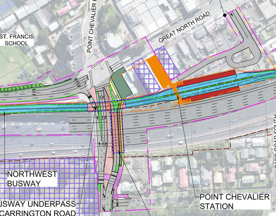
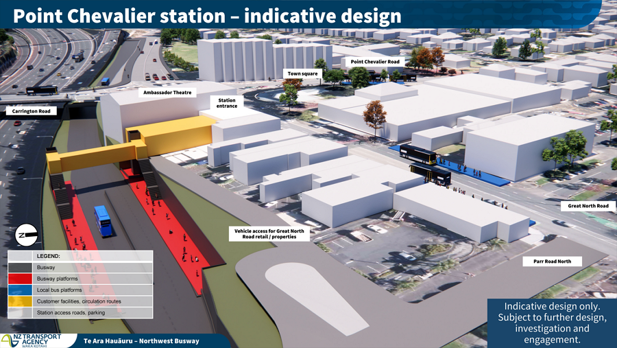
Pt Chevalier
There are currently up to four lanes citybound heading up Gt North Rd from the motorway to the intersection with Pt Chevalier Rd/Carrington Rd. The plan is to reduce this to two lanes, shifting Gt North Rd around to make space for the busway.
The busway will then pass under Carrington Rd (along with a new bridge over the motorway) before arriving at the Pt Chevalier station, which will be located on the current council-owned carpark behind the shops.
Again, a new bridge over the motorway is being built here and Carrington Rd is getting dedicated bike lanes. And yet despite all that space, there doesn’t appear to be a northbound bike lane included in the plan?
Western Springs
As the busway approaches St Lukes Rd, it will raise up on a bridge and pass by the Pōhutukawa that line Gt North Rd in this section. A report on these (and other) trees in the corridor notes that while some trimming of some branches and maybe some roots, will be required, the Pōhutukawa can remain.
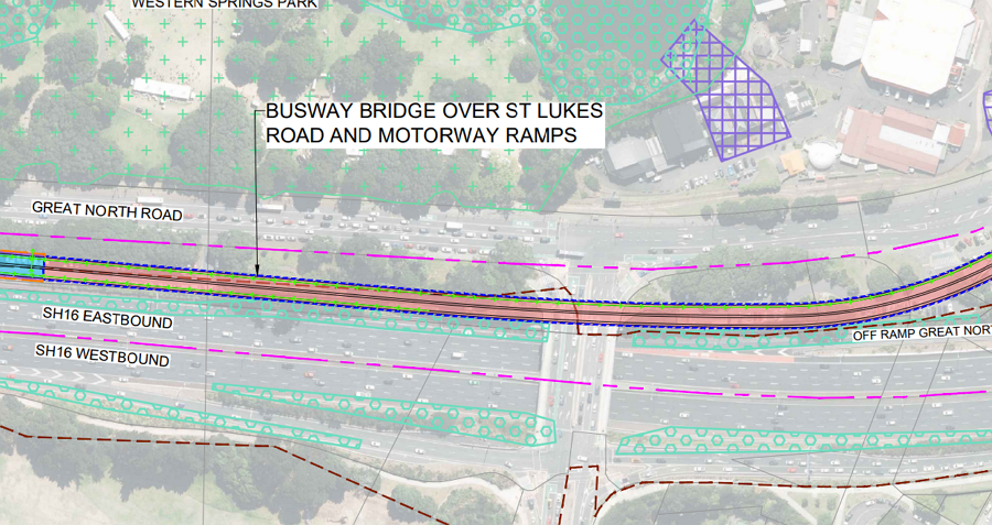
The bridge will continue over St Lukes Rd and then the motorway onramps, before arriving at an elevated station at Western Springs, at Ivanhoe Road (near MOTAT and the stadium). They note:
The station forecourt has been designed to accommodate large crowds, with sufficient space and clear sightlines to support safe and efficient passenger movement. It also provides direct connections to key pedestrian crossings over Great North Road, minimising interchange distances to nearby bus stops and enhancing overall accessibility.
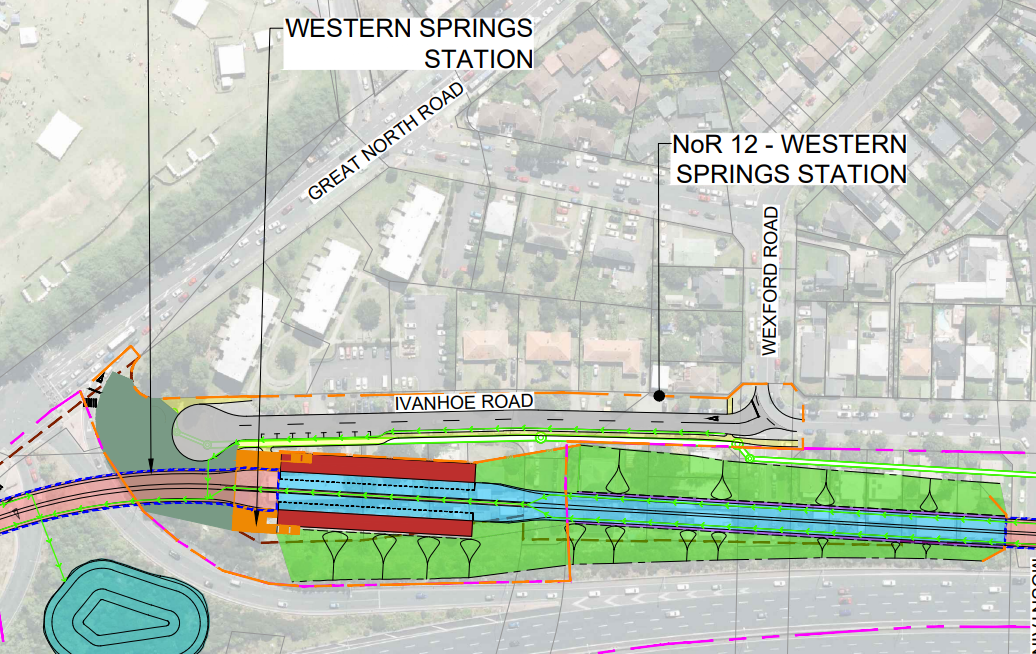
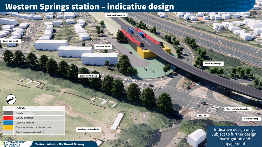
East of the station, the plan is to take some of the Arch Hill Scenic Reserve. I wonder if more could have been done to tighten up the motorway lanes through here to avoid doing that? (Ed: Note there is also an existing path through here, which could be upgraded with lighting and width to provide safer access for walking and cycling)

City Connection
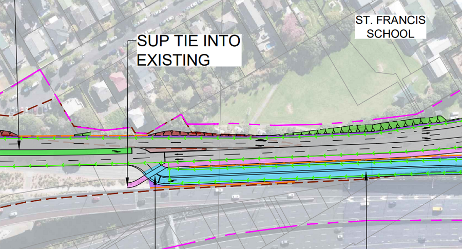
How the busway connects to the city is perhaps one of the most bizarre parts of the plan. After passing alongside the northern edge of the motorway, the busway then ramps up and over the Waima-Haslett footbridge, while also crossing the motorway.
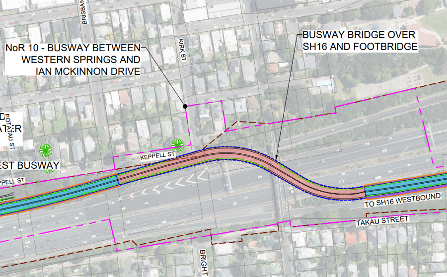 It then ramps back down again to pass under Newton Rd and connects to Ian McKinnon Dr. As at Te Atatū, the cycleway needs to be moved here, so it can also pass below the level of the road. This will mean that the grade will increase, with sections above 5%.
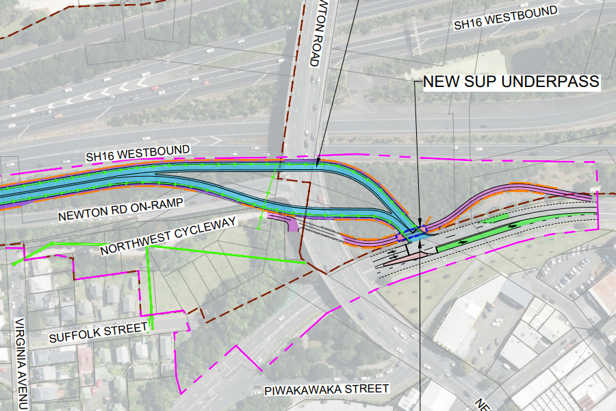
The problem with this is that buses – the majority from the Northwest – will then have to pass though the middle of Karangahape Rd. This seems like it has potential to be of the most unreliable sections on the route.
It feels like something like the route below could be a far cheaper and easier solution – but it appears to have been dismissed because Auckland Transport are scared of suggesting any more changes to K Rd.
Is there anything else that stands out from the application?
Also, throwback to this great data-rich guest post about how well the interim busway is working.
Greater Auckland’s work is made possible by generous donations from our readers and fans. We’re now a registered charity, so your donations are tax-deductible. If you’d like to support our work you can join our circle of supporters here.

 Processing...
How much is it costing taxpayers?
A hell of a lot less than an additional 4 lanes of traffic would cost, if only National had built it originally when they had the chance. Hopefully you ask the same of the RONs
National gets shut for building too many roads and not enough roads. Labour get it wrong too. Quit with the yawning rhetoric. Aucklands traffic woes began in the 60’s when some arrogant pricka decided they knew better than someone who knew much better than them. Nothing to do with either party
So much more than it should because it is being retro-fitted into a right of way that the transport agency never future-proofed for, in other words doesn’t exist.
It is essentially a clear example of why having a single mode focused transport agency is inefficient. Planning and strategy fail.
As we said at the time, the widening of SH16 without including a rapid transit right of way was a huge and costly mistake. As it was we only got the shared use path included after court action.
If that’s your first question I hope it doubles them.
So we’re spending close to $5 billion for a busway that will move less people than the Northern busway moves today? While I’m happy we’re getting more bus infrastructure in Auckland I think that’s crazy, especially given how little the Northern busway cost. Curious to know how many people light rail would be moving per year and how it compares to both busways as well – could be interesting analysis for another post. Also it seems like most people using this comes from Westgate or Kumeu, which means this busway is effectively benefiting urban sprawl.
Sadly the sprawl has happened, happening and being further enabled to continue to happen. At least this will give some the option of not using a car for all of life’s journey’s.
Cost just seems to be the cost of massive projects. Again, this could highlight the case for motorway lane reallocation, to avoid some of the bridge structures and under/over passes. But it could be similar to CRL, that a big chunk of the cost is in the stations.
I’m also hoping that walking / bike connections to the stations can be included in designs as they emerge, and they’re simply being left out at this stage due to Simeon’s horrible GPS.
The cost of building transit in the Anglosphere is absurd compared to the rest of the world. Something truly needs to happen or these countries will keep falling behind.
Aside from the unwillingness to consider repurposing lanes for PT in favour of a massive construction effort, I am concerned that at the public consultations it was made pretty clear there was no thought or interest in addressing bus priority on Lincoln or Te Atatū Rds.
That’s AT, not NZTA.
It was both who essentially said nothing was being considered – but yes I understand the local roads come under AT, to my mind it shows a lack of care, When AT used modelling to show people returning from the city at night could have a 45 minute wait at Lincoln Road for a connecting service you wonder if they actually support PT here.
I’m not going to defend AT here – I don’t know enough about local buses there, and if they really wanted to improve Lincoln Rd they’d put a lane each way as a bus/ambulance lane, increase the frequency and put a bunch of cameras in, and add a cycle lane/put a median barrier in some of those dodgy bits to stop traffic making bad turns across multiple lanes of traffic.
It does look like there are a bunch of buses still operating at night there, e.g. the 14 which looks roughly every 15 mins – so not sure how they got 45 mins? If you missed 1 by a second, then they cancelled the 2nd one, and then they cancelled a third bus, then the 4th bus you caught it’d be 45 mins. I’m not sure what time the buses stop/reduce their frequency along there though.
Hi Freddy, yeah 15 minutes up to 8pm, then every 30 mins. Their modelling used persona of people coming back from city after an event.
Fund it!
It should have been included with the widen of SH16, so running for a decade already, keeping the motorway more functional, and fixing a huge access issue for the city.
Very happy with this except for the city connection, which defies even basic logic- why switch over to the east only to go back west. Plus is over-engineered and costly.
Please extend the super successful NW cycleway with this work. Don’t make the same mistake made last decade of excluding contiguous works just because of mode-focused thinking. It’s all transport- Waka Kotahi.
Love the note about the Pohutukawa, thank-you.
If it looks like a RoN and smells like a RoN, it might just be more RoNS
Does the design take into account eventual conversion to light rail?
NO. Real future proofing is very difficult in the current set up, except for highways.
I wouldn’t worry about ‘future proofing for light rail’. It will never be converted to light rail just like the Northern busway will never be converted to light rail.
Question – what are the purple hatched areas?
Heritage sites
Compared to Light Rail/ Tram stops in Australia, Gold Coast and Melbourne, The UK, Manchester and Sheffield, and on Continental Europe the planned Bus Stops here seem to expensively over engineered. Specified by cost plus engaged consultants?
They build to most of the cost/route of higher modes – but Nats don’t want anything bar buses (heavy truck/bus lobby, tyre lobby etc), and other parties either don’t care or are happy to see anything. Save a few million in CAPEX for an extra few million in OPEX every year. Forever. Doesn’t make financial sense.
So a $10B winding mess of endless bridges, trenches and disruptions to services + the pathway, with the only design consideration seemingly being to never ever touch the almighty motorway.
How much would it be to liberate two lanes of the existing motorway and put light rail tracks on them, even if the overall corridor was widened to allow it?
Think the designers may have been huffing too much road paint while coming up with this genius idea. Wasted effort IMO
‘Don’t want to disrupt K Road again?’ They won’t be disrupting it for another 20 years by the time construction starts on that part, what on earth are they on about…by that time K Road will be crying out for Light Rail integrated into the CRL.
if at peak it can move the same as 4 motorway lanes why not just take one lane from each direction now and put the money and effort into getting people to use that through ease of access, synergising with north western routes etc? this seems like an overengineered mess guaranteed to go way over budget or to fail to launch like Labour’s over worked ALR.
Yes ! although since in their fast track info one of their benefits stated is improving journey for cars, I somehow doubt they will take your cheaper, emission friendly solution on board.
Far too obvious and far too cheap.
Will be interesting to see whether recect discussions about getting better use out of our existing infrastructure starts to take off.
At the moment the idea of removing lanes from a motorway would go down like a lead balloon, but maybe that could change.
Do you think we could get better use of our existing light rail infrastructure (MOTAT)?
No, but I know a troll that does.
True
Its good that there are a few things for the cyclists I suppose.
I agree with other commentators, it looks (to my untrained eye) more expensive than it ought to be.
How much much would a light rail option cost?
I assume nobody knows because it’s ‘not my job’ to price it
I suppose its fair enough to a point as accurate costing is an expensive task in and of itself.
That said, I’d be interested in even back-of-envelope estimates.
My suspicion is that much of the projected expenses would relate to the stations and various bridges. If this is an accurate impression, I would simply be in favour of light rail.
This would be because: (i) mode bias (I like rail); (ii) future capacity proofing; and (iii) it might lead to other light rail projects being commenced elsewhere in the Country.
The main extra cost with light rail is having to do the whole thing at once including the causeway.
What causeway? Also why not build it in stages like every construction project ever
The rather big one that runs between Te Atatu and Pt Chevalier and is mentioned specifically in this article.
The proposed busway will still use shoulder lanes on this section which is a significant cost saving.
Yes you can stage LR but the bit needed most and to be built first is between Westgate and Te Atatu, which wouldn’t be much use as an isolated section of LR.
Google is telling me Te Atatū has a population of ~14,000, and Westgate is still being built, a few weeks I was being told you need millions of people to justify building light rail networks… Which is it
Selective use of google there – “Te Atatū (Peninsula and South combined) is a diverse Auckland suburb with an estimated population exceeding 30,000 as of 2023–2025. The area, divided into the Peninsula (~14,000+) and South (~15,300+)” And then you have “As of 30 June 2024, the estimated resident population of Massey (Auckland, NZ) was approximately 27,400 people”
I don’t know, I’ve neither claimed millions are needed for LR nor am I suggesting we should be building LR along this route.
Also where does the new harbour crossing light rail fit into all this
Puts CRL cost well into perspective… clearly value for money as it delivers true rapid transit on three lines, not just one, and includes fixing the most difficult section- the city centre. This, by contrast, creates further bus pressure there.
The city centre can probably take two full busways plus all local buses, but it will mean much more street space will have to become bus only in the future.
Those lobbying for more car space in the city, other than just being flat out wrong – that can not improve anything, are on a permanently loosing battle with sheer bus volumes. The city centre will be pedestrian and bus dominated, with everything else squeezing in around them.
It is urgent that the bus fleet transitions to 100% electric as fast as possible to make this bearable. This has a significant influence on liveability.
re city connection – could just go up newton, across at the top, short stretch of ponsonby rd, turn right into hopetoun and use it and hopetoun bridge as more or dedicated busway then down into vincent and albert. direct, but loses connectivity to krd station i guess
Add a stop on Hopetoun at Beresford Sq and you have a short transfer to K Road Station.
Looks like they could fairly easily turn it into automated light metro or light rail, probably not heavy, if they did the termination point @Mercury Lane and did an elevated section over the causeway.
Again, it’s mostly unfunded so if they do the hard yards of land acquisition now they can change the mode to a more future proof one later.
It would be great if the design thinking was shared. First thoughts:
1. Bringham Creek station should be on the other side of Bringham Creek, servicing Kumeu and Riverhead.
2. I wonder why they didn’t put the TeAtatu interchange on the empty land on the other side of the Motorway.
3. Why didn’t they move the bus across the motorway at Lincoln Road? Surely less disruptive than ripping out all those houses. Requires moving the rugby league pitch.
4. The (non) city exit is just ludicrous unless it somehow connects to the underground station.
5. Totally ridiculous that this wasn’t planned for / delivered during the motorway extension.
1. Re Brigham Creek – I think if they build a pedestrian bridge across to the new subdivisions on the other side, I don’t think it’ll matter that much.
Most of the users will either be driving or taking local PT to it – and it’s chosen because the land is more empty I think. In the distant future it’ll just be one stop on the route to Kumeu (they’ve designated the corridor but it’ll probably happen when the motorway is extended), and it’ll be surrounded by sprawl, so as long as there are good local walking/bike routes/PT, it won’t matter which side as there will always be vast swathes of suburbia losing/gaining.
2. Not sure – guessing it’s so the busway wouldn’t have to switch sides/buses from the city wouldn’t have to cross from one side to another. There seems to be lower value uses on the south side of the motorway, especially east of Lincoln Rd. Plus people are generally less annoyed about other poorer people losing their homes than green space they might use. It’s not a wealthy suburb so far easier to deal with that. They’ve got a great preplanned corridor @Westgate that is on the south side (future proofing <3), then they own parts of the route on the south, so they probably decided to keep it all on the same side rather than costly bridges switching sides.
3. They've already bought the land on the old radio mast site – it's also closer to everything, as unlikely the heavy industrial area will grow that much on the north side of the motorway. They also evidently own the land on the other south east side of Lincoln Rd/motorway too.
4. Agreed – it's NZTA going 'we want this to not be our problem' – that's why they've left it for AT to figure out what to do with the buses (totally ignoring the reason we build CRL was because there are already going to be too many buses for the streets to handle).
5th. Agreed. Save a few bucks now, cost billions later. Sometimes it's deliberate, sometimes it's just incompetence. Like when they future proofed the new SH20 bridge to take rail over the Onehunga inlet – but they decided that it would only ever need to be single track because the Onehunga branch was single track at the time. Now they'll have to build a new bridge for whatever form of rapid transit goes along that corridor – as you can't really have a high frequency route and have it alternating single direction.
Like that example, the planners probably just didn't even consider that there would be a future need for anything, and whoever who did would've looked at the cost of future planning and vetoed it.
Is that for real the Onehunga crossing? I thought ARTA had to pay for the bridge foundations to be stronger to accommodate this – it seems absurd if it wasn’t even done right?
Is that for real the Onehunga crossing? I thought ARTA had to pay for the bridge foundations to be stronger to accommodate this – it seems absurd if it wasn’t even done right?
Yeah only future proofed for a single track, just laughable that a condition can be so weak to allow for something like that
There’s a huge commercial development between the actual Whenuapai development and the motorway. Not to mention the charging stations for the buses that will run on the NW busway, which will have to traverse the still inexplicably not yet fixed Brigham Creek roundabout, which is already a congested mess now and will still be one in 2039 or whenever this is actually looked at.
I thought the Te Reo name for Westgate/Northwest station was gonna be Pukewhakataratara?
Can we call it a fast-road application instead?
The city centre connections makes perfect sense if the buses go down Queen Street. It makes no sense if the plan is to go down Albert. Im really not keen on having NW and Dominion Road buses both going down Queen Street, but it would force LRT to happen much earlier.
Moving the Pt Chev entrance down a couple doors to be right at the crossing would probably be better choice, certainly would reduce j-walkers and risk of accidents associated.
I think they’re trying to make it as close as possible to Pt Chev/Carrington Rds – as you have the Outer Link/65/66, connections to the new Carrington massive subdivisions, and Unitec. Probably easier for them to just move the traffic lights and redevelop the arcade. The lights are only where they are because of the arcade entrance, if they put lights on the Huia/Parr Rd intersection, then moved the other lights to be more outside the new entrance/closer to the library, it’d probably be the best of both worlds.
I wrote my own post based on your November post, but only just got around to finishing and publishing it after seeing this one.
Largely agree with you but wonder why take a lane was not more seriously considered. It would considerably simplify the bus runs and has potential to make the overhead stations (Pt Chev, Te Atatu, maybe even Royal Rd) much simpler and similar.
Like your idea to link Don Buck Rd area to Triangle Rd with a boardwalk but I also found a cheap easy Kumeu – Westgate connection that avoids SH16 to consider.
https://www.robincapper.net/northwest-busway-fixes-for-the-sh16-northwestern-cycle-path/
Good write up, thanks for sharing
I thought there was no room for more buses in the city centre?
Exactly, just shows the folly of not already having light rail down Queen Street that this rapid transit route could also feed into
No mention of the hundreds of private homes and businesses you need to acquisition in order for this project to be built nor concern for the communities you will be tearing up in order to run buses through them. That alone is going to cost hundreds of millions of dollars while you model it off the successful eastern corridor which only cost 660 million. This is projected to be 12 to 14 billion at best and at least 20 to 30 years away and we all know how much this cost is going to balloon out. They don’t even have the funding nor even entertaining the idea of private partnerships, its to be totally funded by the government, you the tax payer.
Has this been compared with the cost now of installing a centre-running busway along the existing motorway, with lifts/stairs to local connecting stations on the overbridges?
I bet not. Like others have said, lotta money wasted due to not building it way back while doing the SH16 widening.
> Is there a PARADOX with cost of busses vs Rail we could examine: Busses are considered cheap pb transport because they go on existing roads.
BUT – it seems the infrastructure for busses is more expensive than rail infrastructure ( surface)
-And then the fact they busses will still cause traffic at ends and take few passangers compared to rail. Surely nimble rail routes that can weave around places would be better. Also the CONTRADICTION of mass transit being beside a motorway.. – Mass transit should go through towns and hubs and improves an area.. If we already have a motorway then thats already a transport route … I think more creative thinking is needed NW
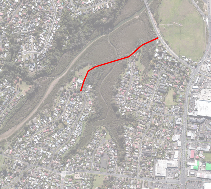
Te Ara Hauāuru – Northwest Busway – its potential effect on Arch Hill.
It is certainly true that the ‘City Connection’ is one of the bizarre parts of the plan – but what about the potential massive negative effect on the residents of Arch Hill based on the bare-bones information to date?
Regardless, the properties on the south side of Partridge St. will at least be compulsorily procured (removed or not)
It is planned that the slipway from the busway (think 2-way same as Northern Busway on the shore) will rise up over THE TOP OF the Waima-Haslett footbridge and then underneath Newton Road bridge to land at Ian McKinnon Drive (road level) – a 2-lane highway at least 20m above the light standards on the footbridge.
We see the loss of amenity for the remaining properties adjacent to and above, to the north will be substantial based on the current scenario.
• Removal of native vegetation / tree cover beside motorway – increase of Nth Western traffic noise up the hill
• Visual encroachment – a 2-lane suspended motorway in close proximity to and directly in the sightline (towards Mt Eden) of the remaining properties in Partridge and above (Home / Monmouth / Kepple Streets and Newton Central School.
• Suspended lighting on the slipway creating night time light pollution
• Noise encroachment – even with electric buses there will be traffic noise until near midnight and early in the morning which cannot be mitigated because the slipway will be suspended and no sound deadening possible except along the walls of the slipway.
• The heritage expert review has come in with a low/no detrimental effect on Arch Hill. Not only is this premature but un-realistic as there is no actual visualisation plan available to be assessed therefore purely conjecture. The Grey Lynn Residents Assn. has already asked for but not received any applicable documentation.
Maybe a simpler and possibly less expensive option would be to remove the current foot bridge – lower the busway and build a new longer but further-up-the-hill- each-side new footbridge à la the decorative art triumph of Jacob’s Ladder found on Highway 1 adjacent to St Mary’s Bay.
Or just run it along the motorway – 2 lanes
Yes!
No need to ruin Pt Chev and Western Springs amenities for the local community, in order to meet the needs of people who choose to live miles away.
That is the price the inner city pays though. If those people could live closer, many of them would.
so much comes back to the villa belt NIMBYs preventing intensification where it makes the most sense, closest to the central city
Yes, all of us out West decided to look at lovely villas with sections and then thought “Nah, I’d rather choose to live further out and sit in a car park each day during each commute”.
You got us. Definitely the choice we made, nothing to do with affordability or availability of homes or other amenities like schools.
Just think how many homes could be built for $5 billion in areas already close to good transport – and these could provide a return in rent . . .
Are these areas already close to good transport in the room with us right now?
Brigham Creek station needs a footbridge over the motorway to the thousands of new builds going in around Whenuapai. A bridge at Northside Drive is too far away for these people who will otherwise get in their cars and drive to the park n ride through that congested Brigham Creek roundabout.
Royal Road. Why the second bridge? Seems expensive and unnecessary for the busway. It requires the removal of a bunch of houses between the school and the motorway and on the other side of the motorway at Lansdale Place which ups the cost, and all it seems to provide is 2 unnecessary bus lanes over the motorway and avoid a water main running along the underside of the bridge. Far more efficient is to build the interchange on the other side of Royal Road in the unused piece of land boundaried by Royal, Makora and the motorway.
AT’s proposed interchange sits above the busway which requires removing the existing cliff next to the motorway. My suggested site doesn’t need so much excavation since it is already the level of the motorway and the interchange can be built above it at Royal Rd level.
If the only reason for the second bridge is clearance for buses under the existing bridge and water main, may I suggest they dig down a bit for the busway to go under the bridge.
I mean NZTA, not AT.
Alongside Triangle Rd between near Awhi Lane and Exotic Pl the bus lane can be much closer to the motorway and shared path so as not to take so much land from the houses. The proposal is so invasive those houses on Triangle Rd still theoretically remaining will be removed.
Lincoln Rd. Great but we do not need three road accesses to the station – two for buses and one for cars – cutting up the greenspace making it less usable for other purposes such as sports fields or parks. We only need one road accessway to and from Triangle Rd where the proposed bus access is.
The proposed bus access from Lincoln Rd is only usable by buses driving north on Lincoln to the station which can just as easily go down Triangle and then into the terminal that way. It provides no access for buses leaving the terminal back onto Lincoln.
The public access to the terminal further along Triangle Rd can be combined with the bus access and then those streams can be separated to the different pickup and drop off points. This creates a much better use of the green space. Also means there won’t need to be 2 new sets of traffic lights on Triangle Rd but only the one, thus easing traffic on Triangle.
There’s an unneccessary (and probably expensive) loop of road at the west end of the terminal that loops around under the busway and seems to serve no purpose. It replicates the local bus drive that runs around the terminal.
Good idea Matt on the walkway to Riverside Cres.
Te Atatū. The new bridge over the motorway is a good idea. But everything about this station is too big and expansive, thus impinging far more onto the surrounds than it needs to and making it less human-scale and more driver-scale.
The bridge itself is in the wrong place. Its southern end should be at the eastern end of the busway station so that city bound buses don’t have to do a loop back to get on the bridge. They should be able to pick up at the busway terminal and head straight out onto the bridge across. Also local buses to the Peninsula and southwards would be more direct by a bridge that deviates less from Te Atatū Rd. The local bus terminal orientation would need to change to north-south, perpendicular to the busway terminal and snug next to the motorway. The bridge itself should cross the motorway to the west of the existing bridge so that on the northern side it reaches the middle of the island created by the big turn of the city bound car on ramp, and then the bridge itself should curve (as it does in AT’s proposal) and cross Te Atatū Rd to land on the other side and distribute buses toward the city and to and from the Pen. The power lines will need to be raised to fit the new bridge no matter where it is.
This will use far less space and impinge far less on the surrounding houses. The arc of AT’s proposed bridge wipes out a lot of houses because it is so massive and sweeping, like it is for a train or motorway but buses will be going slowly through here and can make tighter turns than trains. Moving the local terminal so it is next to and parallel to Te Atatū Rd will save a lot of houses on Royal View Rd. That saves a lot of money and disruption to local residents.
If they need an access for buses to get on and off the busway, rather than build a new curving street that wipes out more houses, use McCormick Rd which is 100 metres west and already exists.
On that north side, the bridge extends further into the park that it needs to. The bridge should end tight against the existing motorway on ramps, allowing the eastern busway on ramp to merge with the existing on ramp sooner.
And so much of this extensive and intrusive construction you outline could be avoided by repurposing existing lanes for the busway. In essence what this does is remove PT from motorway to allow for and encourage more cars.
What is happening in the world right now should surely show we should be rethinking how we keep building fossil fuel dependancy into our systems.
Too many of the grey haired, or no haired at all, brigade, those currently in charge of our country, and their supporters, continue to wish that today was more like yesterday.
So they are intent on using yesterday’s solutions for today’s problems.
And tomorrow’s problems? Well they have more limited tomorrows then the general population, so they just do not want to know.
West of Te Atatū there are a lot of houses needing to be cleared that don’t need to go with a tighter design that keeps the busway close to the motorway and moves the shared path over. The shared path will be very unpleasant with motorway on one side and busway on the other so it should go outside the busway. More importantly, the whole project should minimise demolition of houses for cost and community sake. The current design of the whole project is grandiose.
As a cyclist, the cityside plan gives me the heebie-jeebies. OVER the footbridge, and then UNDER Newton Rd? And the bikes to go UNDER that road? Clusterfuck! That needs to change.
Pt Chev. Looks pretty good. If they’re building a new bridge for Carrington Rd perhaps they can also extend it at the southern end so that the Northwestern Cycleway can run alongside the motorway under Carrington Rd instead of having to divert up Sutherland Rd and the awkward crossing over Carrington Rd.
Western Springs. The plan here looks pretty strange. The elevated bus path is fine but it should hug the motorway rather than deviate near Gt Nth Rd which is a waste of land. The station should not be at Ivanhoe Rd but west of the off ramp, where the gas station is now. That means less demolition of Ivanhoe Rd and also it’ll make the station closer to MOTAT and the Zoo which will actually be the most common use for this station. It’s also closer to the crossing to Western Springs.
The proposed plan is unnecessarily expansive and expensive. A more efficient plan would be far better again here.
funny, that exact suggestion (demolish the petrol station and use that land for the bus station) was in one of the very first GreaterAuckland posts about the NW busway back in 2009: https://www.greaterauckland.org.nz/2009/08/11/northwest-busway/
I see they’ve adopted some of the ideas in that article which is good, but not others which is not so good.
Which ideas in particular?
City Connection – Instead of the excessive elevated path OVER the footbridge, there are two options. I describe them from the perspective of heading into the city.
The first is that the busway continues under the footbridge where the Newton Rd offramp is currently, which is moved over several metres so that it departs the motorway slightly later and slightly steeper to Newton Rd. Once under the footbridge, the busway can either take a bridge over or a tunnel under the Newton offramp and the motorway across to space between the west-bound Newton onramp and the motorway, as already proposed and continue up to McKinnon Dr. McKinnon Dr and upper Q st seems the least disruptive entry and exit point for buses to the city.
The second option is that as before, the busway continues under the footbridge where the Newton Rd offramp is currently, which is moved over several metres, but then instead of a large bridge over the motorway, the busway goes to Newton Rd next to the offramp, turns left up Newton Rd joining traffic to the Ponsonby, Gt Nth Rd and K Rd intersection and turning right into K Rd. The additional bus traffic on K Rd may require bus lanes along K Rd which is not ideal for a community like K Rd, so option 1 is better.
The westbound leaving the city is the same in reverse.
Vaguely related to the city approach but I wince at the thought of how much cutting into the Arch Hill bush they want to do.
Incidentally, i remember the 2017–2019 proposals for the Northwestern Busway included a station at Bond Street, which seems like it would be good for transfers to the route 20 frequent bus, but I’m not sure how a station would work with the Bond St overbridge pillars.
A closer inspection of this document (diagram on page 5-23) seems to suggest the preferred site of a Arch Hill/Bond St station would have been a few hundred metres *west* of Bond St, which doesn’t seem fit for any transfers to local buses. So at this point it seems like the frequent buses along Great North Rd would be considered sufficient for Arch Hill and Grey Lynn residents catching citybound buses.
https://fyi.org.nz/request/6722/response/22300/attach/5/NWRTC%20IBC%20Draft%20for%20release%20under%20LGOIMA%20October%202017.pdf