One of the few major transport projects that we agree with the government on is the Northwest busway and it’s about to take another step closer to reality.
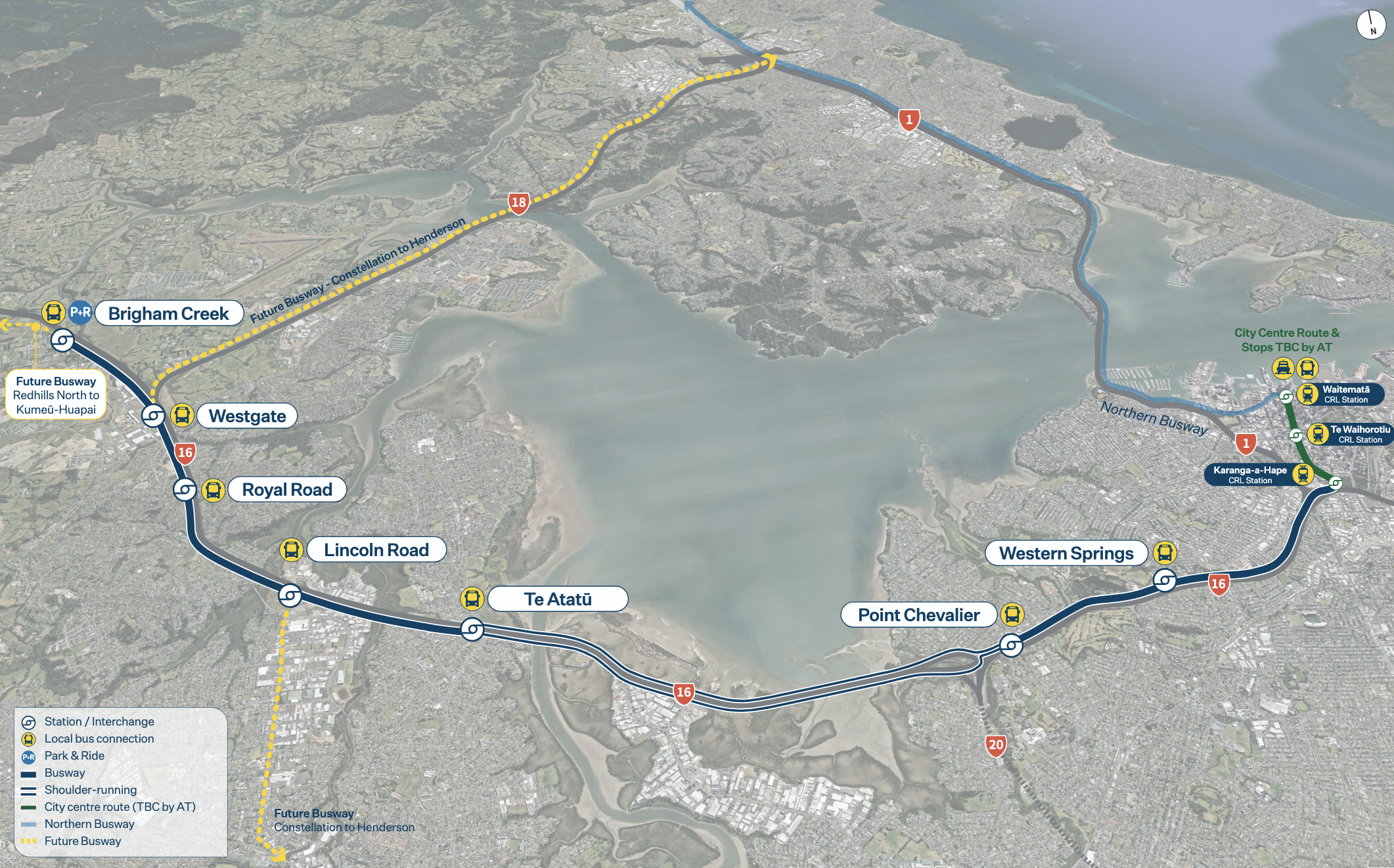
A high-level view of the plans for the NW Busway
Earlier this year it was announced that the NZTA board had approved an investment case for the project and that more work would happen
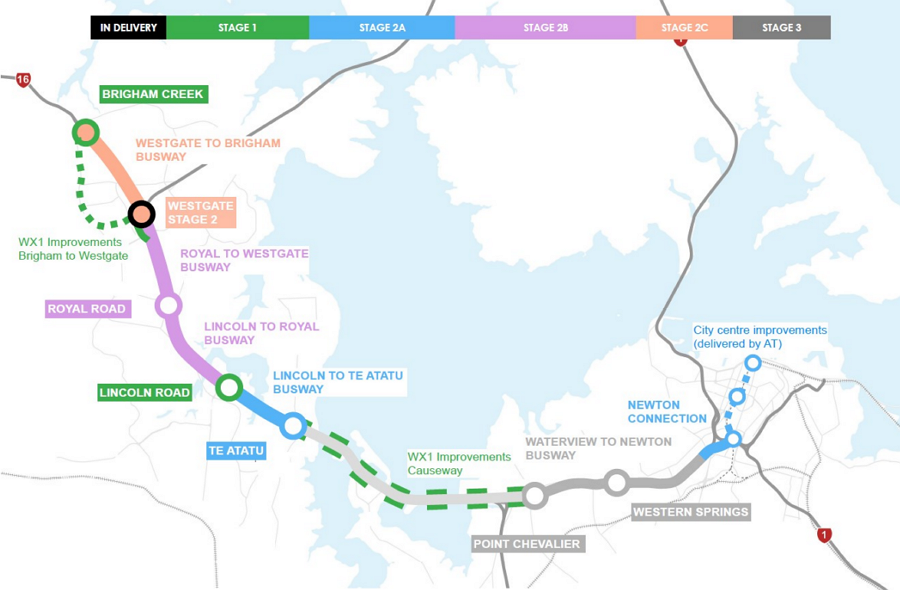
“Funding of around $116 million has also already been approved by the NZTA Board in late 2024 for early consenting work and strategic property acquisitions for Brigham Creek and Lincoln Road stations. Depending on further funding availability, construction of the Northwest Busway could begin from 2027.
“Stage 1 will see new stations at Brigham Creek and Lincoln Road as part of a $330m – $380m package of work. Stage 2 will include the separated and bi-directional busway from Brigham Creek to Te Atatū, along with the stations at Royal Road and Te Atatū, the second stage of Westgate station, and the city centre connection at Newton at an estimated investment of $4,100m – $4,600m*. The Point Chevalier and Western Springs stations are to be delivered as a third stage.
“NZTA will be engaging with stakeholders and landowners to discuss what the Northwest Busway means for them and next steps. Further design and investigation work will be carried out in the coming months, ahead of lodging Notices of Requirement. The project will now seek to obtain statutory approvals for the project, likely via the Fast Track Approvals Act.
NZTA are planning to lodge those notices of requirement next month and are now starting to share more information about the project and they’ve provided us with some of the early designs for the busway and stations along the way.
Let’s work out way though the stations.
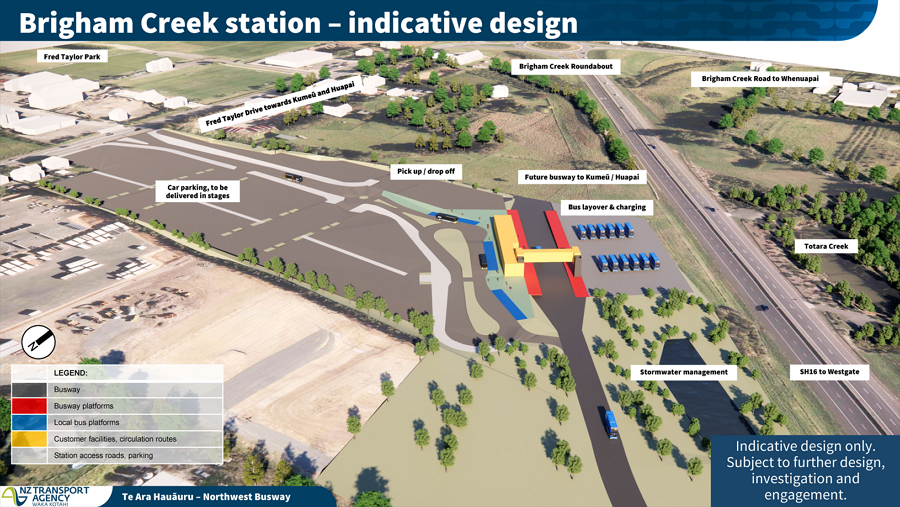
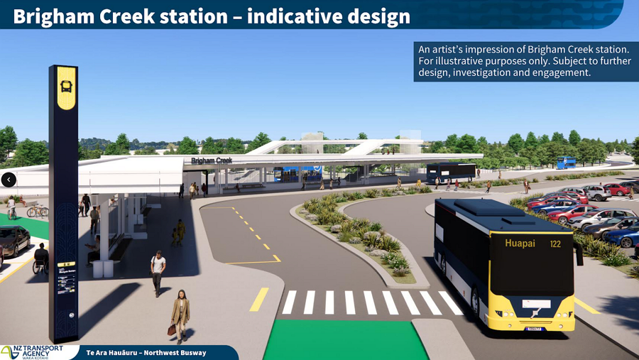
Brigham Creek
The initial ‘end of the line’ station, the main purpose of this station is to serve the surrounding rural areas and as such, is the only station with park and ride included. Much like was done with Constellation Dr Station, initially it likely won’t have the motorway side platforms initially.
One thing they’ve done with the design here is to put the “non-human” infrastructure, like stormwater ponds and bus layover/charging between the busway and motorway to keep it out of the way.
Westgate
The first stage of the Westgate Station is already under construction and like the Brigham Creek design, will include the local bus stops and one of the platforms that will eventually become part of the busway. Essentially the area within the dotted line in the image below.
When the busway is built dedicated platforms for it will be added.
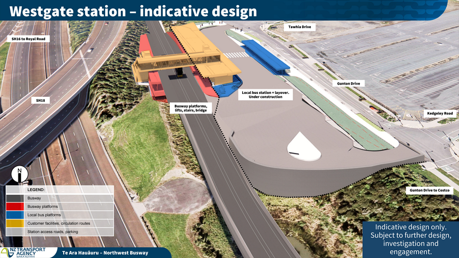
Heading south the busway will pass under Fred Taylor Dr and the team say they’ve future proofed for a potential Westgate South Station. The existing cycleway between Westgate and Royal Rd will be shifted west (beside the houses) to make way for the busway.
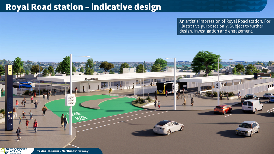
Royal Rd
At Royal Rd the plan is to build a new bridge to the north of the existing bridge to provide stops for local buses and access down to the platforms. It is also useful for the stageability of building the busway.
The cycleway also benefits here by getting a path under the bridge instead of the current situation of quite a steep section up from the off-ramp to Royal Rd, however, there is still a need for cyclists to cross the lights at the off-ramp – NZTA say it has been designed so a bridge could be added in the future but not as part of this project.
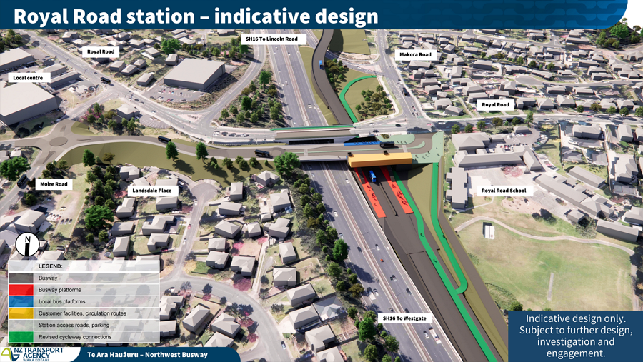
Between Royal Rd and Te Atatu there are apparently a lot of services just under or beside the cycleway which would be very tricky (expensive) to move and so one major aspect you can see from here is the busway will run to the west/south of cycleway. Put another way, the cycleway will be sitting between the motorway and busway which isn’t ideal and will remove existing access to the cycleway in some locations.
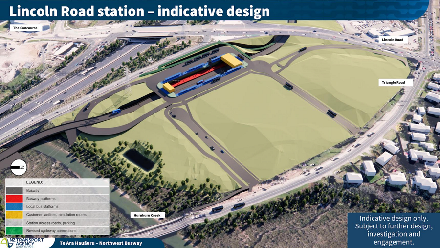
Lincoln Rd
At Lincoln Rd the plan is to make use of the existing radio tower site which is up for sale and they’ve come up with an interesting design of a trenched station. The busway itself would be in a trench while local buses would use stops located above the station. This is essentially the same as how the New Lynn train station at works.
You can also see the cycleway will also get to use an underpass of Lincoln Rd avoiding the current situation of having to cross four sets of traffic lights.
They say the internal road network of the site is still being worked on so there’s quite a good chance it could change, especially as the remaining site will be an opportunity for development.
Te Atatu
Te Atatu is made tricky because there are currently no plans to extend the busway across the causeway, instead they’ll continue to use the bus shoulder lanes like they do today.
However, citybound buses are likely to lose a lot of time trying to get though the motorway interchange, especially at peak times and so the big plan here is to build a bridge across the motorway so buses can more easily access the on-ramps. The bridge would also be used by local buses to/from Te Atatu Peninsula so they could easily access the station. It’s a bit hard to see but there’s a ramp up to the new bridge just to the left of the station platforms.
A bus underpass of Te Atatu Rd will be built but it will only initially be used by westbound buses however it is designed so that citybound buses could use it if a future project was to extend the busway across the causeway. This is very much like at Akoranga and the bus underpass of Esmonde Rd.
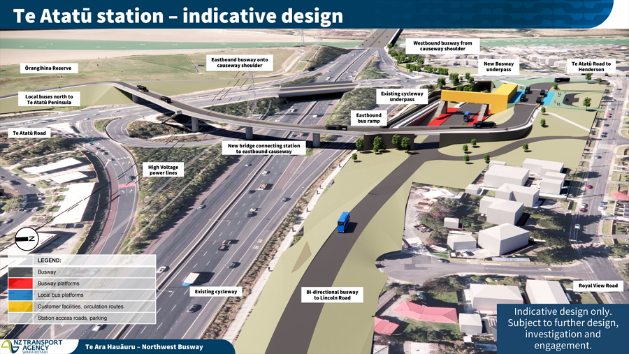
This plan does take out the existing McCormick Green and the project say they’re in discussions with the council about options for replacing it and what that replacement option looks like.
Pt Chevalier Station
At Pt Chev buses will use the existing motorway ramps but heading up Gt North Rd towards Pt Chev a busway will be squeezed in and will pass under Carrington Rd to a station tucked in behind the Pt Chev shops. They want to create access to the station through one of the existing buildings.
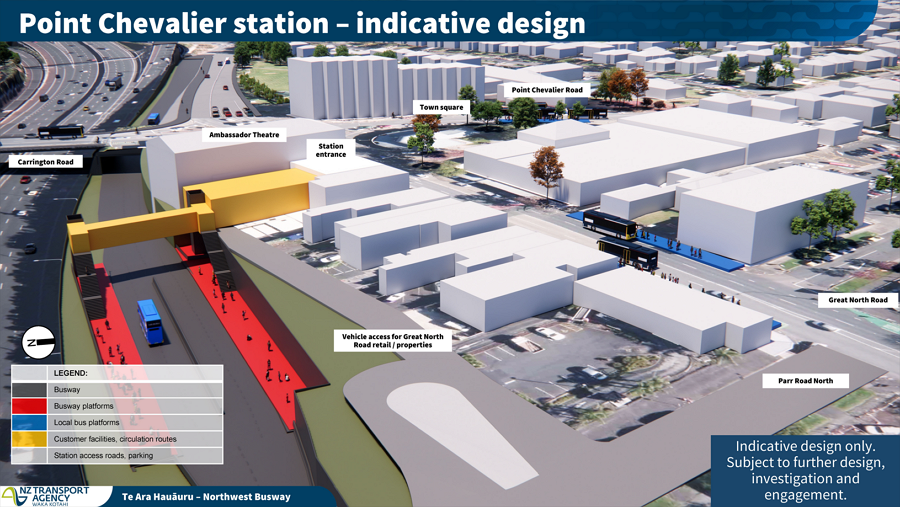
Because the busway wasn’t future proofed years ago and New World have just finished building a supermarket right up to the motorway boundary the plan is to shift the motorway slightly by squeezing it up a bit to create just enough room for the busway to get through.
Western Springs
Heading east, the busway will go over the top of St Lukes Rd and stay elevated to cross the motorway ramps where it will then arrive at an elevated Western Springs station. It’s not shown in this image but it would likely have stairs down to the plaza area by the onramp. It could also potentially have a bridge across to Western Springs for use in events and it would be good to see one over the motorway to help the catchment there too.
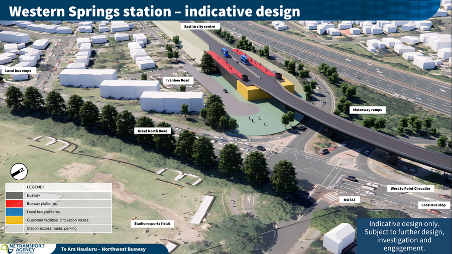
From Western Springs the busway would continue alongside the motorway till around Newton Rd where the thinking is it would cross over the motorway to Ian McKinnon Dr and Upper Queen St in order to access the city centre – though given that the section from Pt Chev to the City is likely a very long way there’s a good chance that could change.
One thing these images highlight is that infrastructure like this is not cheap and the Brigham Creek to Te Atatu works are estimated at $4-5 billion. There probably very little difference in cost between doing it as a bus or light rail. Where there is a difference though, is in the ability to build the busway in smaller staged sections.
I do wonder how different things would be had this been done at the same time as we were rebuilding interchanges and widening the motorway only a decade ago.
If you want more details there are some information sessions being held this week and
Wednesday 12 November, 6-8pm – Te Atatū Peninsula Community Centre, 595 Te Atatū Road.
Thursday 13 November, 6-8pm – Grey Lynn Library Hall, 474 Great North Road.
Saturday 15 November, 9-11am – OneTwoSix Church, 126 Point Chevalier Road.

 Processing...
That price. The cost of not taking any steps to prepare for this earlier.
>There probably very little difference in cost between doing it as a bus or light rail. Where there is a difference though, is in the ability to build the busway in smaller staged sections.
We need all of it ASAP though and light rail allows for higher future-proofed capacity. The current plan is a $10 billion busway that likely won’t be finished for close to ten years. It’s literally 100 times the cost of the Northern Busway!
We’ve just seen the prime example of taking the the all or nothing approach with ALR.
It failed.
Projects simply have to be stagable, and deliver solid benefits and good usage from the earliest stage. The motorway builders figured this out a couple decades ago.
Agree, Mike Lee and Christine Fletcher (for all their other issues) figures this out for rail a couple of decades ago. Now we’re on the cusp of the CRL opening.
Crazy that this can cost that much
They really need to work out how to have bus lanes from Westgate to Kumeu, the traffic is absolutely catastrophic. Maybe some kind of tidal central bus lane?
They just need to stop building houses at Kumeu and Huapai and address the infrastructure first
Still no good solution for the city centre? This was always the great advantage of Light Rail running on Queen St to terminate at Customs St opposite Te Komititanga, and back out again. No need to circulate around a city block as buses do.
Queen St would have the great quality of George St in Sydney. Fewer higher capacity vehicles overall. There would need to be a bigger initial investment, depot etc. But in the end the busway will be just as costly, as show above. Operating cost would make an interesting comparison.
Of course the failure to reserve the RoW for this just a decade ago a huge and costly example of our shortsightedness for PT.
Are we doing it again there? Hard to tell, but is this infrastructure designed to easily upgrade to Light Rail? They certainly aren’t saying so. Please don’t repeat past mistakes.
We know we are heading to a bus quantity problem in the city centre, as every future RT line is buses now. Additionally a two-lane busway can meet a lot of demand, until a point, then it can only grow with huge widening, better to enable a rail future for the RoW.
Please.
Yes, LRT in city centre would be a much nicer solution.
I agree. George St in Sydney is awesome. No competing traffic on George St itself other than across the intersections. Circular Quay to Central Station & beyond. Thus would gave been a real winner for Queen St & would have kept the shops open.
Perhaps with a change of government, this project could be specc’d towards Light Rail at the last minute.
Such a change would need to be a bit of ‘captains call’ and not force a re-start of the existing consultation process (which is – due to our process focused development laws – already over the top).
Criminal really that it wasn’t done when the SH16 improvements were done around a decade ago. However, it’s not going to get any cheaper in the future, time to take the chance to do it once, and do it well.
I’d assume the Newton connection will be in easy walking distance to the new K Rd railway station?
Just love how they lightly mention it will mean some access to the cycleway will go. I will be asking at the meetings what if any consideration was given to reallocating lane space for this instead of a costly ( and devastating to the many residents who are losing homes) build.
I think in reality, access to the cycleway will be better or about the same, even if in some locations it will be affected. This (making it work) is one thing engineers are good at, and the fact that there are connections now means the risk they are permanently removed is much less than if they were hypothetical links in a future plan.
They aren’t going to be removing lanes on the motorway, and if they ever considered it, I bet it was washed out as politically unwanted in the long list phase about a year or two ago…
“Modelling showed you cannot take a lane away from the motorway, as future volumes of traffic show it is required”.
Somthing like that will be the answer.
The modelling that showed lanes can’t be taken from the motorway would likely have been modelling of the 2026 election result.
If this is build is to take 10years we really should be starting from the city centre end. Currently the buses have virtually no priority between the causeway and city centre and as a result of that the whole system becomes very unreliable. The existing bus shoulders further out west (past Te Atatū Rd) are not perfect but still much better than being parked in traffic around Western Springs on daily basis.
Agree, the city centre is a huge bottleneck. I would even suggest, until they can streamline the whole route, splitting it between the city portion and the busway portion. At least that way they would be able to keep the busway portion running to schedule.
We should be starting from both ends and aiming to meet in the middle.
Maybe they can sort that out for the northern busway too. Reallocate some St Mary’s Bay and Harbour Bridge lanes for buses and cycle lanes.
Agree 100%! Start from the city centre and work out; don’t bring mroe buses into the existing bottlenecks.
Better yet, take one traffic lane each way for the bus instead 🙂
Does getting the busway built mean that converting it to light rail in the future would be considerably easier?
I also wonder if it wouldn’t be wise to use the new Busway bridge at Royal Rd to clip on a overhead cycleway to the same structure so users don’t need to deal with crossing at the on ramp – instead of building another, currently not planned, bridge just for cyclists.
Thanks for the post!
+1
And the same for Lincoln Rd, Carrington Rd and St Lukes Rd
The main consideration for light rail is the slope gradient can’t be too big, and ideally use sweeping corner curves.
Anon, that’s heavy rail. Light rail can handle 6-10% gradients and has better acceleration/deceleration for curves.
National Party will be instructing NZTA to ensure light rail is no longer possible via gradients, bridges, etc. Although just building the busway will do that anyway, its hard to make a business case for LR stack up when a busway already offers most of the benefits.
I am really surprised National haven’t done a bus solution for Dominion Road to kill off LR for good.
“put the “non-human” infrastructure, like stormwater ponds and bus layover/charging between the busway and motorway to keep it out of the way”
I think one of the rationales is that if you put more lanes next to a motorway there is political pressure to use them for general traffic. Hence David Parker used to talk about having the busway physically separate from the motorway where possible.
Great to see some progress on public transport at last. It’s hard to see from this how pedestrians will access the bus stops, many seem to be out in the open away from destinations or in the middle of car parking. Hopefully the next stages will focus in on this essential element.
Do they plan to extend the busway up Lincoln Road to Henderson Railway Station?
Will it be fully accessible?
Will the buses on this route have bike racks?
AT have had plans for Lincoln Rd for around a decade but it was to spend a huge amount of money to only add transit lanes and only on the northern most half of Lincoln Rd.
It has been on hold due to lack of funding
This is so disappointing – Lincoln Road is one of the country’s most traffic clogged streets and it has virtually no accommodation for public transport, cyclists or pedestrians (good luck to those who dare cross it).
And it is such an obvious piece of the puzzle- people jumping off the all new NW Busway and hopping onto a bus along Lincoln Rd ( and the others) and then crawling along in heavy traffic.
Yes it’s great that this project is happening, but I would have preferred we take a traffic lane each way for bus priority, but that’s not going to happen because apparently the car is king This will not take an inch of space allocated for cars. That’s not the way you transition Auckland into a green, climate-forward city, it’s adding more concrete to an already super stressed environment and communities.
There will be a lot of impacts on our community spaces, green spaces and waterways. The flyover in Te Atatu is particularly egregious 🙂 It cuts into the reserve that is an ecologically significant area for shorebirds roosting on that paddock. Plus, it will make that whole area that much more hostile to navigate for pedestrians and cyclists – an industrial hellscape. In which ways can these impacts be mitigated?
Good to hear about the Lincoln Rd underpass, I didn’t catch that at the consultation.
So we need to make sure we ask for mitigations and projects to balance out the loss of amenity. I hassled the engineers yesterday to get us a pedestrian and cycling bridge over the motorway to connect the Whau Pathway to the peninsula, in exchange for these impacts. I won’t hold my breath! Completing the walkway right around the peninsula is another project they could buy my silence with! And Massey and Westgate will have other items on the wishlist.
I’d love to connect with other local who are also concerned – get in touch if you’re keen.
Less convenient (rather than staying along the foreshore with a separate bridge), but if they are set on having that bus bridge on the west side of Te Atatu interchange, why not have a bikeway on that? That could give you a grade-separated Whau Path to Te Atatu walk and cycleway with no signals to cross.
Also could assist Te Atatu North – South cycle links by taking out some signalised crossings (probably too much a detour for walking tho).
That bridge includes walking and cycling and hooks into the shared path along Te Atatu Rd
Yes the plan includes walking and cycling on that flyover, but I’m trying to imagien what it will be like up on there with the buses – not a nice place to be, I’m sure. The interchange is awful to cross at the moment – not sure this is better.
Weird to be a Debbie downer on a public transport project, I see the irony, but this is such a behemoth that will have such severe impacts – and car traffic will be unchanged, there is no reduction in car traffic to offset this!
Meh, as long as path is wide enough and physically separated it will be fine. By the time this is built most, if not all buses using it will be electric so no noise or fume issues. Will get more of both of those from the motorway below.
It looks big but it’s only about 350m long meaning most cyclists will take 1-1.5 minutes to cross it.
Bigger question is how people then access the existing cycleway
Yes it is a pretty poor diagram from that respect, whilst the existing requires traffic crossings this bridge does not seem to allow for any better connections for those coming from the Peninsula for example.
On the bright side it will boost access to the planned Te Atatū Marae.
Both projects would probably benefit from additional ecological offsetting though.
What do you have in mind for the offsetting? Tell the birds to go somewhere else?
Genuine question 🙂
Two busways joined with shoulder running in the middle.
Works for the motorway crowd. Once you have great infra at each end, the missing middle is much easier to get approved for more investment.
Except this is a staged plan and there is no stage for that bit. And look at the price even though they have left out what might be the expensive bit.
Buses can hijack the left lane.
So at Western Springs they’re pretty much going to wipe out a lot of low-income housing on the south side of Ivanhoe Road (and the existing playground just before you get into the Arch Hill gully).
This design will be incredibly convenient for me but, as Zooey says above, gutting that once again the HaveNots are going to have to pay for necessary social progress, because if it inconveniences the Haves to any degree it won’t happen.
In fairness it’s a busway that follows the motorway corridor and it’s likely this is a low-income housing area because of the proximity to the motorway.
So that’s a reason to move them out of Auckland completely, and put them somewhere where they won’t be a nuisance?
Wayne Brown and Simon Bridges will be so happy about that…
That’s some A grade twisting of my words, I’ll respond if you actually post a response to my comment not something Wayne and Simon have said.
Much of that housing is end of life (or not far from it). Redeveloping the rest of the KO land will probably result in more housing overall than what exists today. Key is to ensure that happens.
It would probably be doing everyone a favour.
Usually the only way to deal with a slum is to bowl it (and it’s not as though the inhabitants won’t be offered overspecc’d accommodation elsewhere).
At any rate, the best way to help the poor is to grow the economy – investing in infrastructure is one of the few levers that we have that can achieve this.
They picked that site in part because that depreciated housing is going to be demolished and replaced anyway. This way it gets replaced at higher density next to a new station.
would much prefer it to have been light rail from the start but as that seems politically unpalatable( considering the electorate that would most benefit from it largely votes Blue they kind of get what they deserve a bit). Seems well thought out and using the shoulder on the causeway seems sensible enough. I would prefer to start at the city end as well… that’s where the pinch point currently the greater issue
I think making it LR would ensure it sank alongside the Airport LR project.
The main problem being is it can’t be staged with the causeway as the last stage.
People keep saying LR can’t be staged, but never quite understood that.
Like if you have a couple of biggish chunks of land for the big end stations with PnR, storage/charging bus depots and stations with local bus connections, then you can potentially do one LR stage that connects between bus stations and main terminal point (i.e. the Queen street end).
Means that you can get a (relatively) low cost segment on LR, and while users will have to get off buses (including the local buses) to get on LR, it makes it possible to stage the segments that have the highest demand.
Hence why I said it can’t be staged with the causeway as the last stage.
It could of course be staged to say Pt Chev, then Te Atatu as the 2nd stage. However, I’m not sure either of these (but especially the 2nd stage) would pass a business case.
The real value of this busway comes west of Te Atatu and if it is built as light rail from the start these passengers would have to catch a bus and connect to LR for years.
The good thing about busways like this is they can be upgraded to LRT if need be in the future at much lower cost than building from scratch.
Well with this being a busway I think it’s more likely the Dominion Road Queen Street light rail will be resurrected at some stage. Once memories fade over the political, stupid decisions made to wreck it.
They’ve intentionally made it not upgradable to light rail to save cost on the design (yep, this is the saving cost option!).
Mt Albert, Kelston and Te Atatu are all still solidly Labour.
It’s the example of their caucus that has supplied most of the anti-light rail ammunition over the last decade.
The loss of McCormick Green is no great loss. I cycle past most days and i’ve never seen a soul in it. Its not exactly a biodiversity hot-spot either.
Interesting to see more details on this.
Not convinced on busways. The eastern busway has really destroyed a large swathe of the east. They are a lot wider and more intrusive than anything else. They certainly don’t create people spaces around them, rather people avoid them.
Beside the motorway may be OK. But overall these busways are expensive city killers. Light rail or rail is at least a city hub creator.
The Eastern Busway has only destroyed a large swathe of the east because of the refusal to reallocate roadspace away from private vehicles.
There was more than enough room to put a very viable busway in the existing corridor (or maybe with minimal land acquisition), and particularly through the East Tamaki shops where they diverted it around the back to Burswood.
Light rail would of course have been better.
“The Eastern Busway has only destroyed a large swathe of the east because of the refusal to reallocate roadspace away from private vehicles.” – and this is also exactly what’s happening here
They can be easily upgraded to LRT in the future if demand warrants.
shh shh, don’t mention light rail to him. MRB is a heavy rail cultist who thinks it can magically be built anywhere with less geometric requirements than any other mode and less expense.
I like fixing things with proper solutions rather than fiddly half measures.
I saw some comments on another post about the a-s line. Normally I’m the only one who is positive on it but this time there were many positive comments. Seems we are coming out of the light rail hysteria of recent years. The world is healing.
still not addressing any of the criticisms i made, classic groupthink
i look forward to your a-s line inevitably blowing out to $10-12 billion
I don’t think it is realistic to see BRT as a stepping-stone to light rail.
You would essentially be building the same infrastructure twice and for a relatively small capacity increase.
If anything, it surely makes light rail even more unlikely (which I think is a shame).
It would be fantastic if they could partner to pair bus interchanges (where appropriate) with supermarkets or convenience stores. A far to radical a concept for NZ I’m sure.
Too much money on this and complex stations – Re design is needed smarter.
https://www.google.com/maps/d/u/0/viewer?mid=1Ah5C7l0tkf6Jfjj7CptyWL5hDsJYAKQ&ll=-38.3035463269972%2C175.86804465&z=7
We could have Heavy Rail Similar Route for probably not much more.. Join to the South Down – Junction at PackNSave for City and connecting at Kumeu
https://www.google.com/maps/d/u/0/viewer?mid=1Ah5C7l0tkf6Jfjj7CptyWL5hDsJYAKQ&ll=-38.3035463269972%2C175.86804465&z=7
“interesting” to note that your proposed route slams its way through essential wetlands and native bush parklands…
I would like to see the cost/benefit analysis of the dedicated two-way busway from Pt Chev to the City versus simply a continuation of the shoulder running which will be in place across the causeway, surely a relatively simple shoulder extension would achieve similar capacity, or even better, light rail. Stage 3 is potentially being 10 years away, or potentially not funded at all, and it seems mad to be “future proofing” with buses.
There’s already some shoulder running between Pt Chevalier and the city.
Shoulder running is fine on the causeway where there is only one interchange and no stations.
It would be a poor option with the proposed stations at Pt Chevalier and Western Springs.
What about the houses affected. Why would they want to live there while this is all going on. I think all that area should be commercial. There is only a handful of houses. Dont be tight and use that land also m. Do it right first time. The traffic. Is going to be crap
Couple of thoughts. Compared to today, the biggest improvement to bus priority on that route is the bit between Pt Chev and the city centre. Yet that appears to be the last, distant part of this project. In terms of past mistakes, look at the row of Fletchers homes built on the strip which NZTA cashed up by the Te Atatu eastbound off-ramp. Building a park and ride at Brighams Creek when traffic can’t get there through Kumeu due to congestion, also stands out. Otherwise fine
Now that they have announced details of the Brigham Creek Station hopefully the location of the future North West High School (nearby?) will be confirmed soon.
Brigham Creek station being nowhere near Whenuapai town centre and on the opposite side of the motorway is so on brand it kills me.
Will anything happen to the roundabout or will that still be a shitshow?
As a Whenuapai resident, yea……
I guess when that bridge or whatever it’s going to be, is built next to mitre 10 that goes over the motorway, maybe the buses will at least have better access? But Brigham station will be pretty crap getting onto the motorway in the morning.
It really puts a new urgency around the Northside Drive extension, but supposedly there is a land issue that has stopped that from happening already – you could run the buses through the Spedding development off Brigham Creek and then up Trig Road and back across to Westgate if that was in place.
I fear the ‘temporary plan’ will become for the buses to leave the charging stations in the Spedding development and then sit in the traffic waiting for the roundabout (that now has a signalised wait if the traffic from the city/Kumeu enters an already blocked intersection, which I thought wasn’t actually legal anyway) and we’ll have to wait even longer for Northside Drive to be built along with the Brigham Creek upgrades in a decade’s time.
So yea, this is all kind of worthless without the Brigham Creek roundabout upgrade, and feedback needs to ensure it doesn’t get kicked down the road to be dealt with when they four-lane Brigham Creek road (you know, where they just built a medium density development less than ten years ago and could have done it already without the severe disruption we saw with Spedding Road – Auckland gonna Auckland).
It’;s not meant to be a town centre station, it’s meant to be a hub where buses will spread out to Whenuapia/Kumeu/Riverhead instead
Yes but on the one side is nothing, and no more development happening because there’s no water infra to support it. On the other side there is already an industrial development and the essentially complete Fletcher’s town centre, with plans for a retirement village and additional housing.
Don’t forget Brigham Creek is the main corridor linking SH16 and SH18 and to not have your bus station in the region serving it is all sorts of weird.
There might not be much more development out that way due to the low-lying nature of the area (flood risk).
It’s probably worth going to your local consultation meeting to hear more (and to air your views). You never know.
The suggestions re staging the work from the city end make great sense to me. That approach would deliver quicker wins for more bus users than staging from the Brigham Creek end.
It’s the slow trip between the city and the Te Atatu off-ramps that frustrates me both at night and in the morning.
This board. 50 complaints when a fantastic transport policy that the normal editors, before it became an extension of the extreme green party, kept propagating for.
This solution is much better than any proposal we saw on this board. Its a real busway and its being built in stages so that something actually gets done.
I’m sure some insects will loose their habitats and that a small part of the cycle way goes missing and while thats a pity, if thats the cost for a good busway to NW Auckland, I am all for it.
A busway is a fantastic development for NW Auckland and I hope this will be what both sides support for the election.
Only complaints I can see is that it is very expensive and should have been done ten years ago when it was first proposed.
Not sure how you managed to twist that into “extreme green party”, lols.
The complaints about it not being future proofed for LR (if true) are legitimate, while those about the order it is done are reasonable as well.
There are good reasons to build light rail rather than busways. They have more capacity, take up less space and have lower operating costs. Already we have reached maximum bus numbers entering the city early morning.
Light rail is best built in places that replace the busiest bus routes such as along Dominion Rd or the Northern Busway.
+ 1,000
Website has been updated with new maps https://nzta.govt.nz/projects/northwest-busway/publications.
Picture above showing Pt Chev has the busway between motorway and Gt Nth Rd, with Gt Nth Rd shifted over taking even more land from the little remaining at St Francis school.
Given the increasing population in the area and already overcrowded schools, this feels counterproductive.
I’d suggest this needs rethinking, or any proposed mitigation clarifying. Do they intend to buy out several adjacent houses to replace land?