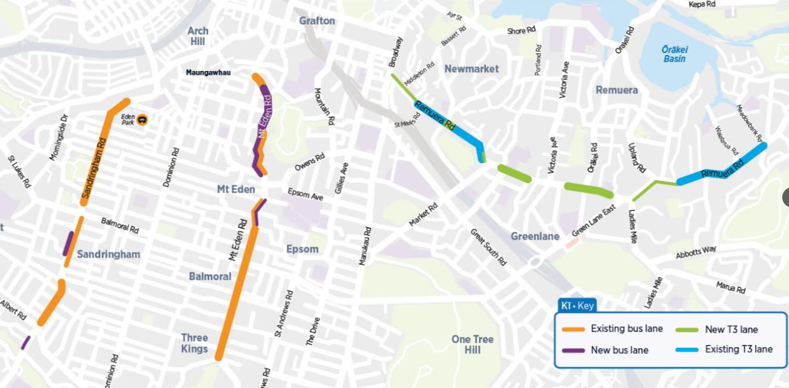
Auckland Transport is proposing improvements to bus and transit lanes on key arterials, for “safer, easier and more reliable journeys” on Remuera Rd, Mt Eden Rd, and Sandringham Rd. There’s a brochure here.
You can give feedback on the plans here until Sunday 23 August.
If you’re feeling a hint of déjà vu, that may be because it’s three years since AT officially canned a programme designed to do exactly this: its Connected Communities programme, which covered twelve corridors.
Connected Communities, aka ConnComm, née the “Integrated Corridor Priority Programme”, was shut down in 2023 after spending five years and $32 million dollars – to deliver one (1) integrated corridor on Great North Rd, which was originally designed prior to the programme starting. It also consulted on, but did not deliver, a multi-modal upgrade to New North Rd.
Along the way, a lot of important local improvements were delayed and sidelined, under the promise that ConnComm would eventually get around to fixing them, leading to a lot of waste and leaving a bad taste. As Matt noted in 2023,
I still recall a stakeholder meeting in early 2020 where a representative for people with disabilities noted that he was blind but even he could see their approach was not going to work.
Anyway, now AT has returned with a laser-like focus on optimising three of the original arterials. From the announcement:
Auckland Transport (AT) is proposing to improve bus and transit lanes on Remuera, Mount Eden, and Sandringham roads to support safer, easier and more reliable journeys.
These roads are three of the most important arterial routes in central Auckland, and lead directly to key train stations, including those on the City Rail link (CRL).
Chris Martin, AT Road Network Optimisation Manager, says the CRL will be the most transformative travel change in Auckland in over six decades.
“Not since the Auckland Harbour Bridge opened in 1959 will we have seen an opportunity to change the way Aucklanders can travel.
“And it’s not just the new underground CRL and the rail network, we want to improve the way Aucklanders get into those train stations, and that’s by joining up our existing transit and bus lanes for continuous travel and better traffic flow at busy times.”
Transit lanes are used by buses, cars with the appropriate number of people (three for Remuera Road), bicycles, and motorcycles.
Our thoughts
Firstly, it’s always fun to see Patrick’s line in the wild, on the CRL as the most transformative project since the Harbour Bridge.
Secondly, at first glance, the proposed improvements count as progress towards the Congestion-Free Network – our vision of an integrated network of transport options to enable Aucklanders to get around the region without being in traffic.
But there’s a catch here. Back in 2018, the plan to optimise arterials for buses came with an implicit mandate to progress the regional cycle network as well: “The programme includes bus priority, safety and cycling upgrades as part of the overall programme”.
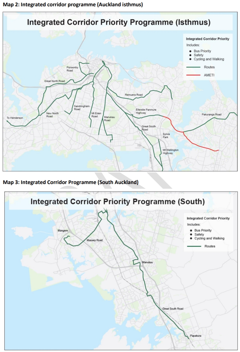
A receipt from 2018: the Integrated Corridor Priority Programme, which became Connected Communities, which was dissolved in 2023.
Unfortunately, the current three proposals barely touch on active modes, aside from a few new signalised crossings. And at least one actively downgrades cycling.
This is a wasted opportunity. Especially given most bus journeys start and end as walking journeys – and given the rising use of bikes for transport in an intertwined omni-crisis of fuel costs, the overall cost of living, and climate change.
Also, these projects are part of the Auckland Network Optimisation Programme which is explicitly multimodal in its aims, as AT explains on the project page for these arterial upgrades:
Aucklanders have told us they want a transport system that:
- is convenient, well-connected, accessible and reliable
- moves them around if they choose to drive, walk, ride a train, bus, bike or ferry.
To be clear: we support the intention. Smooth and reliable bus journeys are key to getting more people to jump aboard public transport. And this is the kind of low-key, no-brainer stuff AT should have been doing for the last decade, instead of pouring millions into the ConnComm complicator.
But we don’t support the execution – especially when it downgrades or deletes parts of the bike network, and prioritises parking over movement.
Let’s take a look at each corridor in turn.
Mt Eden Road
See details on the project page, and see design plans here. This is where Auckland Transport proposes deleting partly-protected on-road bike lanes, in favour of a bit of “shared path”, i.e. bikes on the footpath. This is a backwards step.
Here’s the problem to be solved, as AT sees it:
Mount Eden Road is a busy road that connects neighbourhoods, businesses, schools and local destinations with the city centre. It’s also one of Auckland’s busiest bus routes, carrying thousands of passengers and supporting nearly 30,000 journeys every day.
Keeping people moving along this corridor is becoming more important as Auckland grows. With Maungawhau Station set to open as part of City Rail Link, more people are expected to travel through the area and connect between buses and trains.
Without improvements, congestion and delays will continue to affect journey reliability, particularly during the busiest parts of the day.
We’re proposing improvements that make better use of the space already available on the road.
And here’s what they’re proposing:
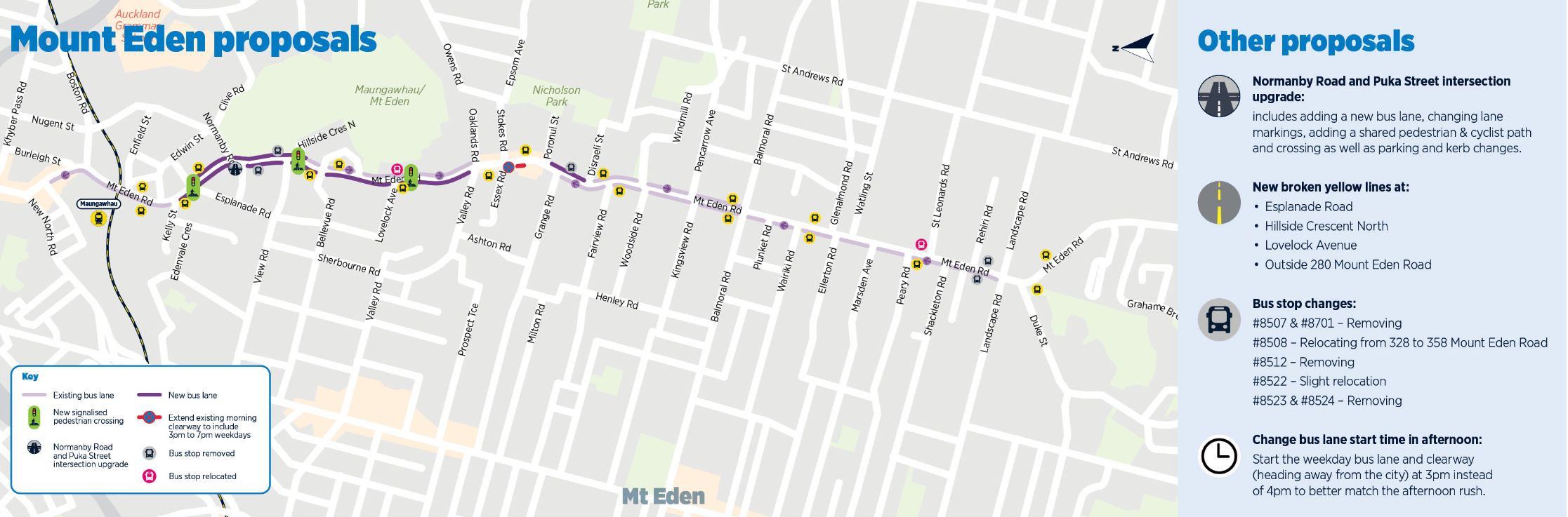
- creating a continuous northbound (citybound) bus lane, from Valley Road to Esplanade Road
- connecting two bits of southbound (away from the city) bus lanes, from Esplanade Road to Percy St
- extending the existing southbound bus lane from Poronui St to Disraeli St
- starting the southbound bus lane an hour earlier, so it will run from 3pm – 7pm
The village shops are carved out, however – even though there’s a dedicated parking lot behind the village:
We are avoiding adding new bus lanes around the Mount Eden Village shops so that there are no parking impacts on local businesses.
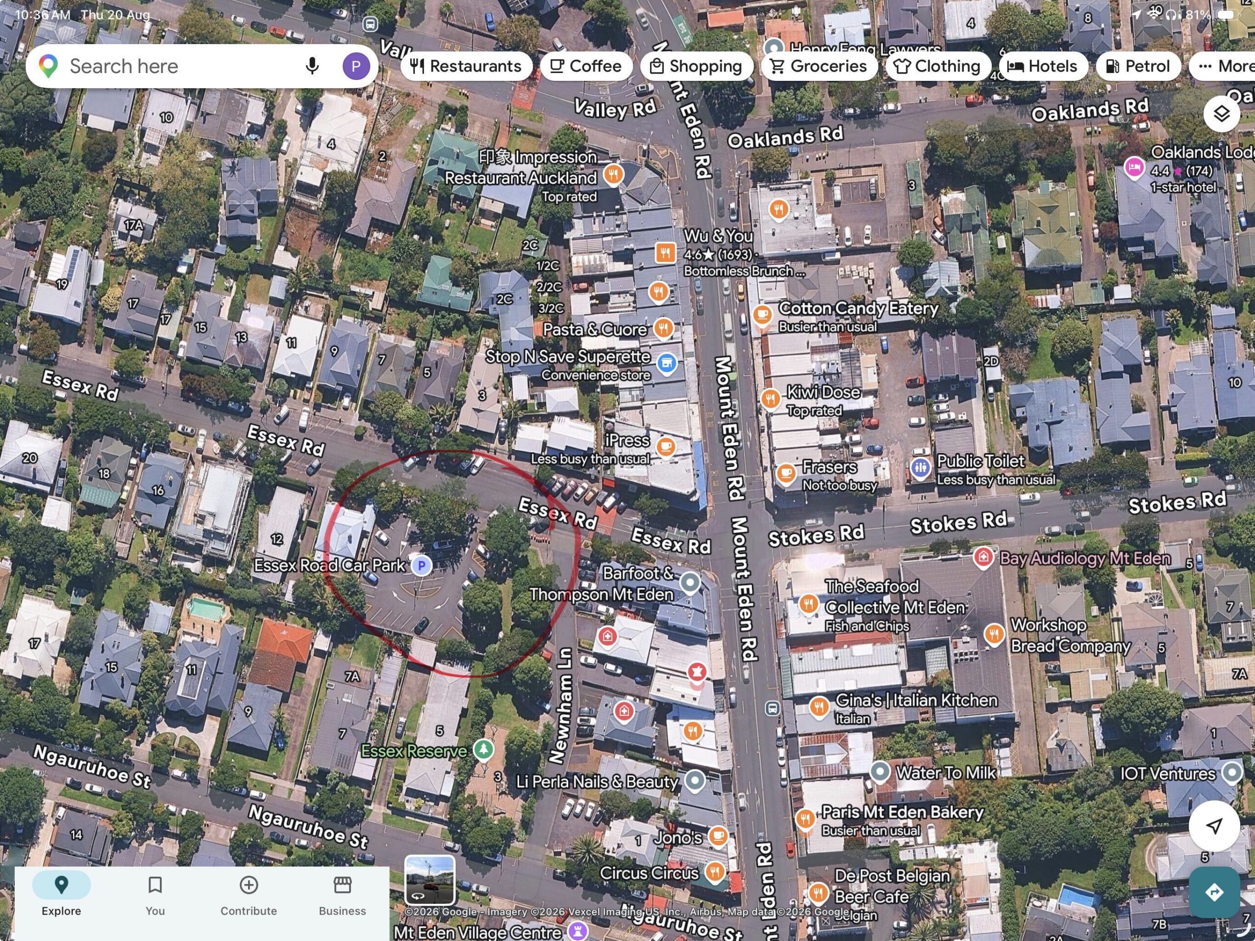
Mt Eden Village, with the parking lot circled in red.
There will be updates to marking and clearways around Stokes and Essex Roads, including an earlier start to the existing northbound clearway between Stokes Road and Ngauruhoe Street (which will run 3pm – 7pm).
Five bus stops are proposed to be removed:
- both Tahaki Reserve bus stops (IDs 8507 and 1870). Nearby stops are close enough to continue to provide an appropriate level of service.
- the Mount Eden Village bus stop (ID 8512) near Grange Road. We will identify nearby locations to replace this stop in later planning stages.
- both Rahiri Road bus stops (IDs 8523 and 8524).
And two others will be shifted:
- the Bridgman Reserve bus stop across from Lovelock Avenue (ID 8508) will be aligned with the new crossing.
- one of the Peary Road bus stops (ID 8522) – to be shifted slightly so it’s more aligned with the stop across from it.
And, for pedestrians, they’re upgrading three existing zebra crossings to signalised (push-button activated) crossings:
- Esplanade Road
- Hillside Crescent North
- Lovelock Avenue
And then there’s this:
Upgrades to Normanby Road and Puka Street intersection
Recently, we installed pedestrian upgrades at this busy intersection to make it easier to cross Mount Eden Road safely. Now, we are looking at further upgrades to add a shared cyclist and pedestrian path alongside our bus lane extension. [emphasis added]
The upgrades include:
- extending the southbound bus lane (going away from the city) to go through the intersection
- installing a new shared path for cyclists and pedestrians across the intersection
- upgrading signalised pedestrian crossings
- adding new cyclist crossing points
- widening the pedestrian refuge island to accommodate people cycling
- minor upgrades to kerbs, traffic islands and road markings to support the new layout.
But there’s no bullet point covering the fact AT plans on deleting existing bike lanes to deliver these “upgrades”. Here’s the proposed new layout:
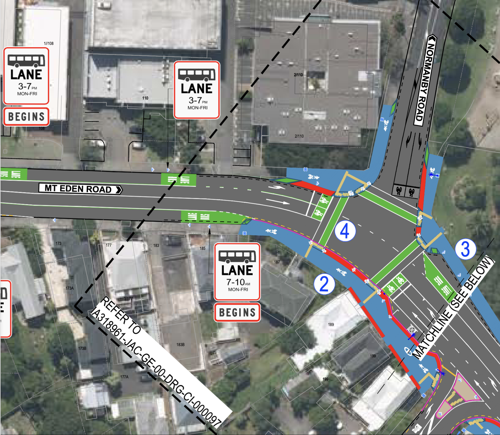 And this is the current road layout, with the existing stretches of (somewhat protected) on-road bike lanes.
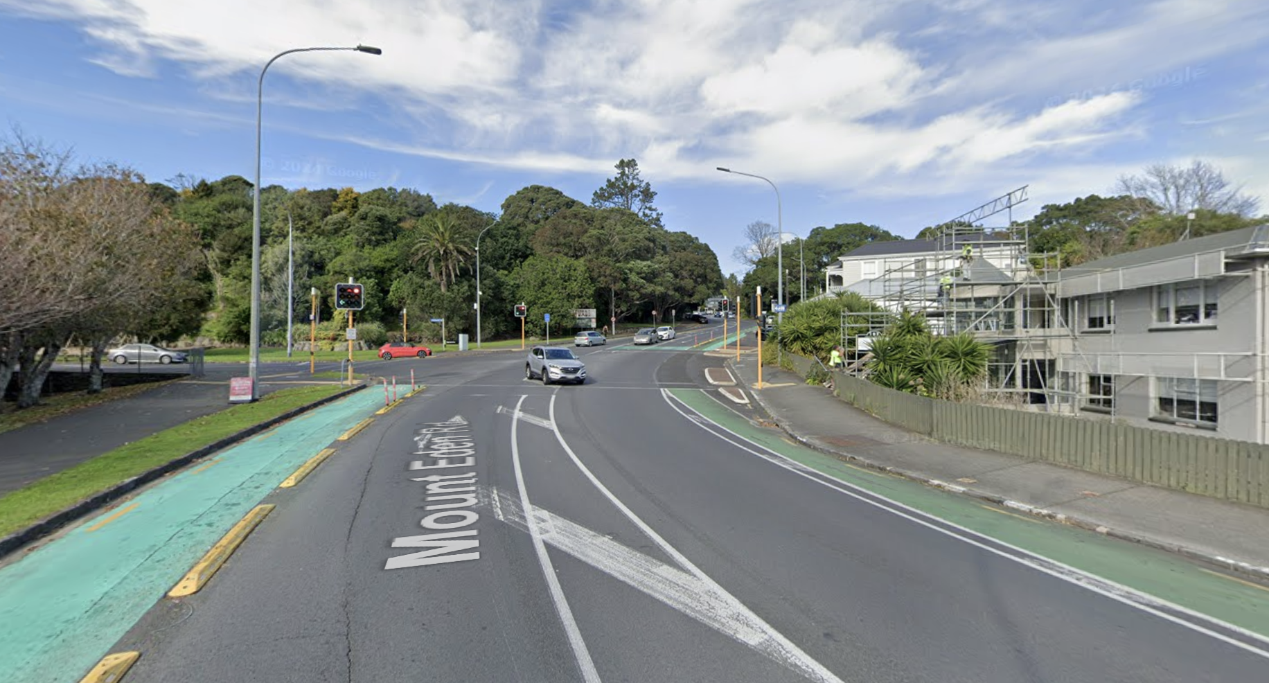
Looking uphill, June 2024 (Google Streetview)
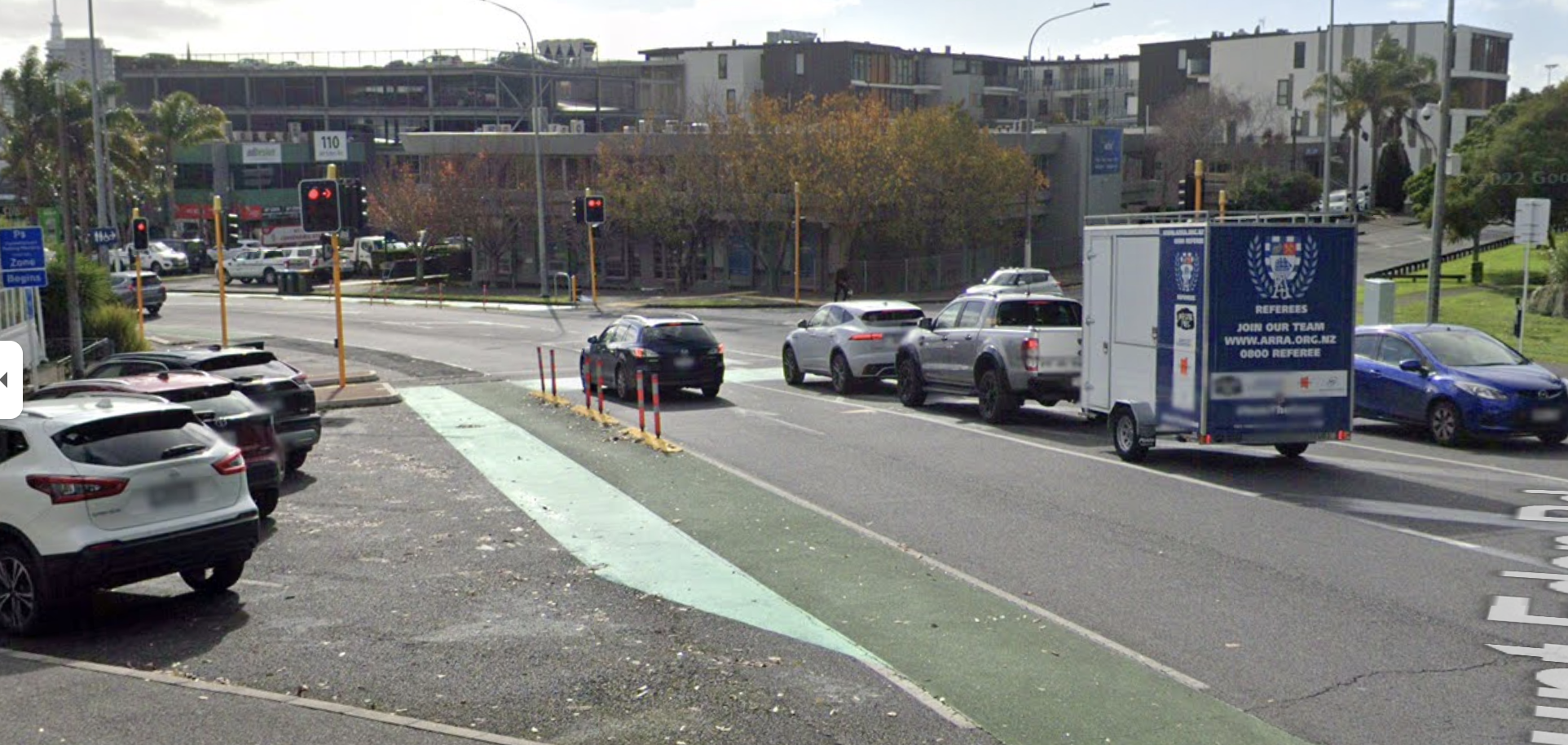
Looking downhill, June 2022 (Google Streetview)
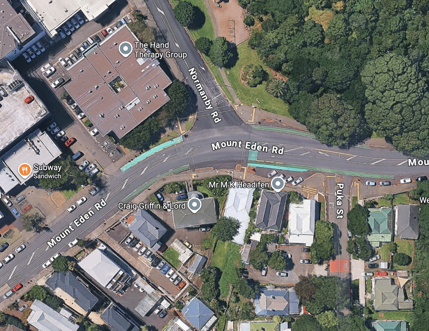
Aerial view of the intersection, 2026 (Google Maps)
These bike lanes were the result of advocacy by Bike Auckland in 2014. They were installed in 2016, and minimal (but valuable) rumble-strip protection was added at a later date. (The downhill protection was quietly removed in the last year – why?).
Traffic lights were installed here in June 2021 as part of the City Rail Link works, and the bike lanes stayed in place. So why remove them now? Why not build on them to extend the network?
Before and after the bike lanes appeared, looking back at Google Streetview, it is striking how often you see someone on a bike trying to enjoy “safer, easier and more reliable journeys” through this location, no matter the layout.
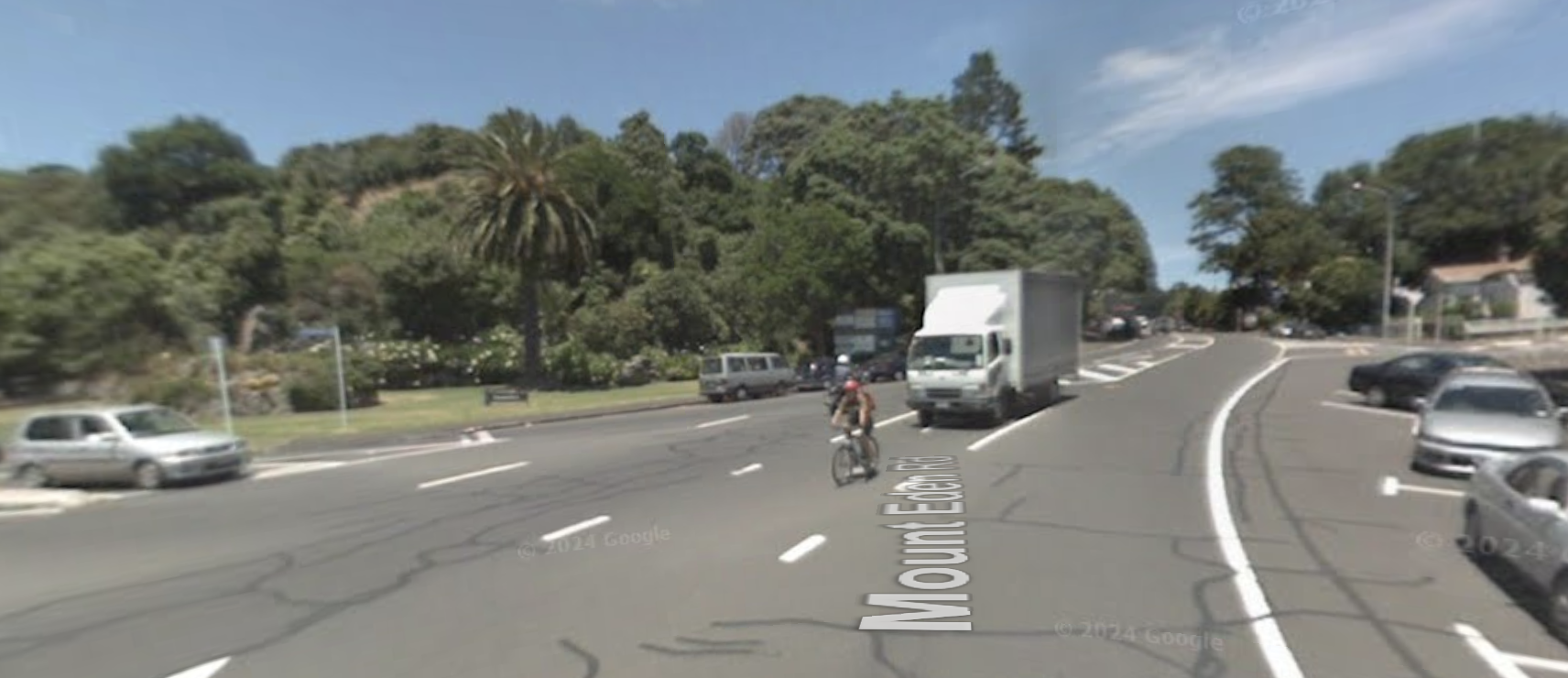
January 2008, before bike lanes or signals.
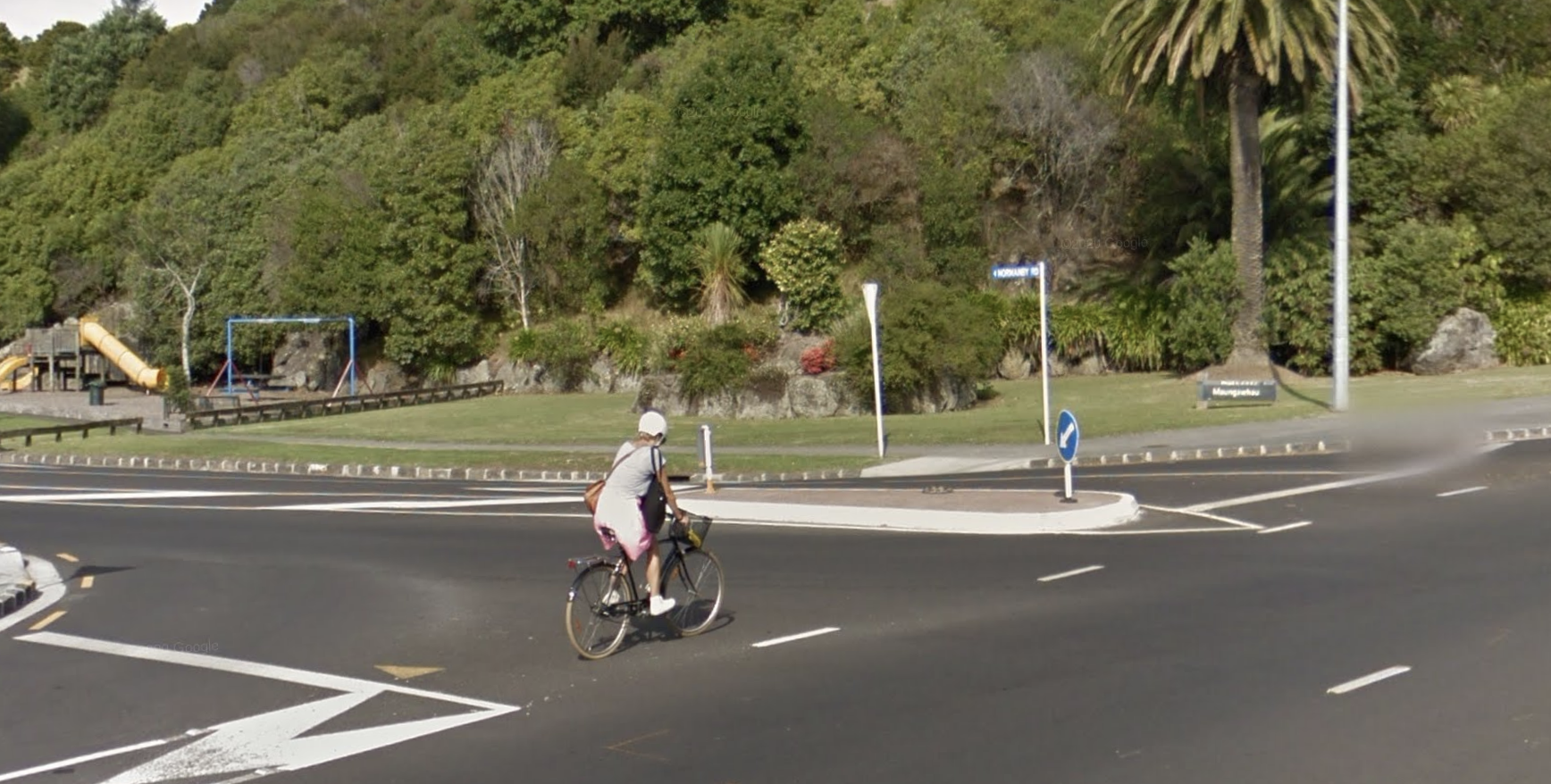
April 2014, before bike lanes or signals.
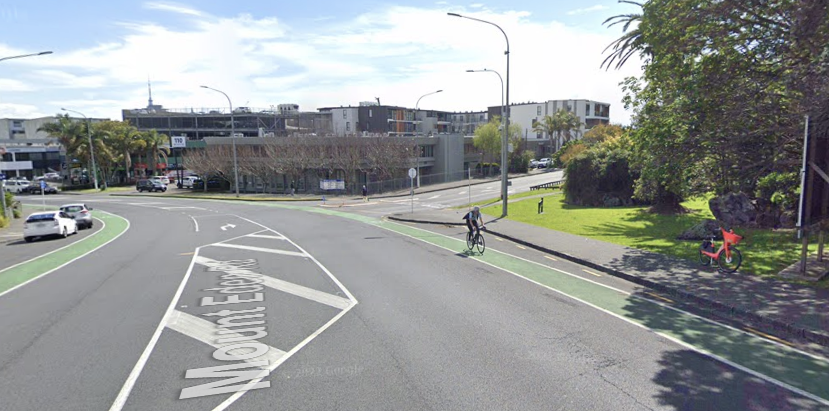
October 2020, with bike lanes, but before signals.
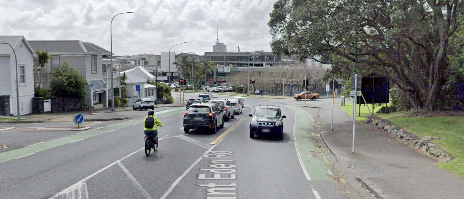
August 2024, even with bike lanes and signals, right-hand turns remain a safety challenge.
One of the safety issues that even paint-only bike lanes can help mitigate – simply by improving visibility of people on bikes on the road – is vehicles exiting side streets, as you can see in the image below.
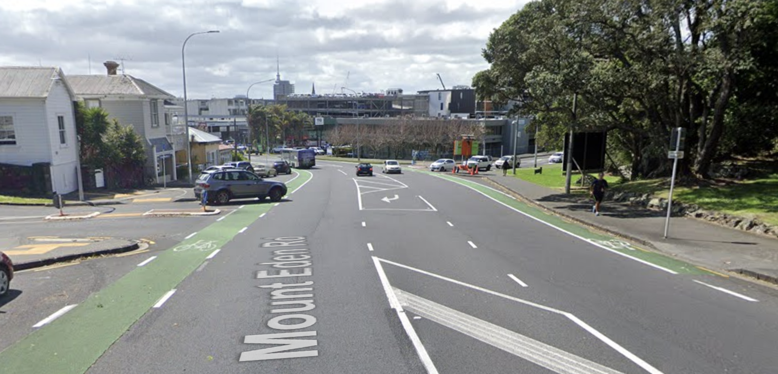
October 2019, vehicle exiting Puka St (Google Streetview).
And here’s another crucial point. Mt Eden Road is a “Major Route” on the Cycling and Micromobility Strategic Network.
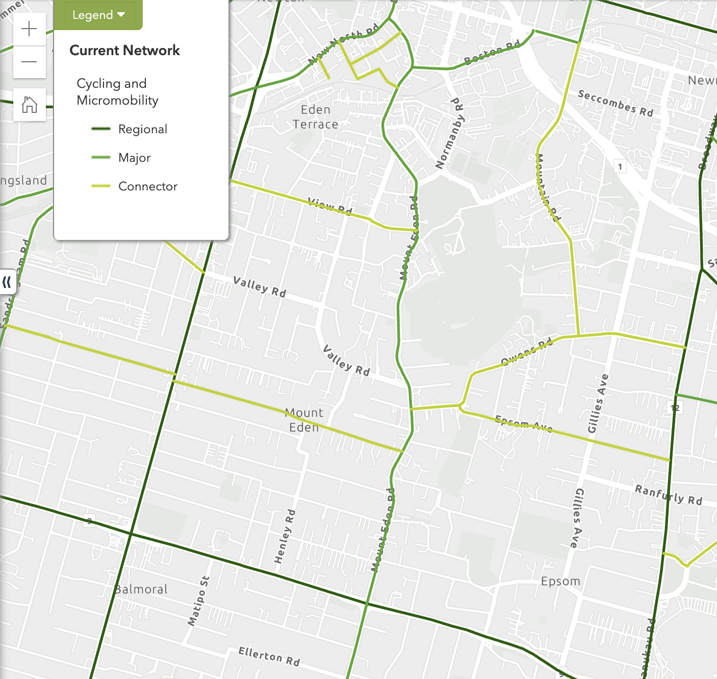
Mt Eden Road on the Strategic Network for Cycling and Micromobility, as per Auckland Transport’s Future Connect planning tool.
It’s also on the Frequent Transit Network for public transport, and is a secondary arterial for General Traffic – as well as a Primary route for walking.
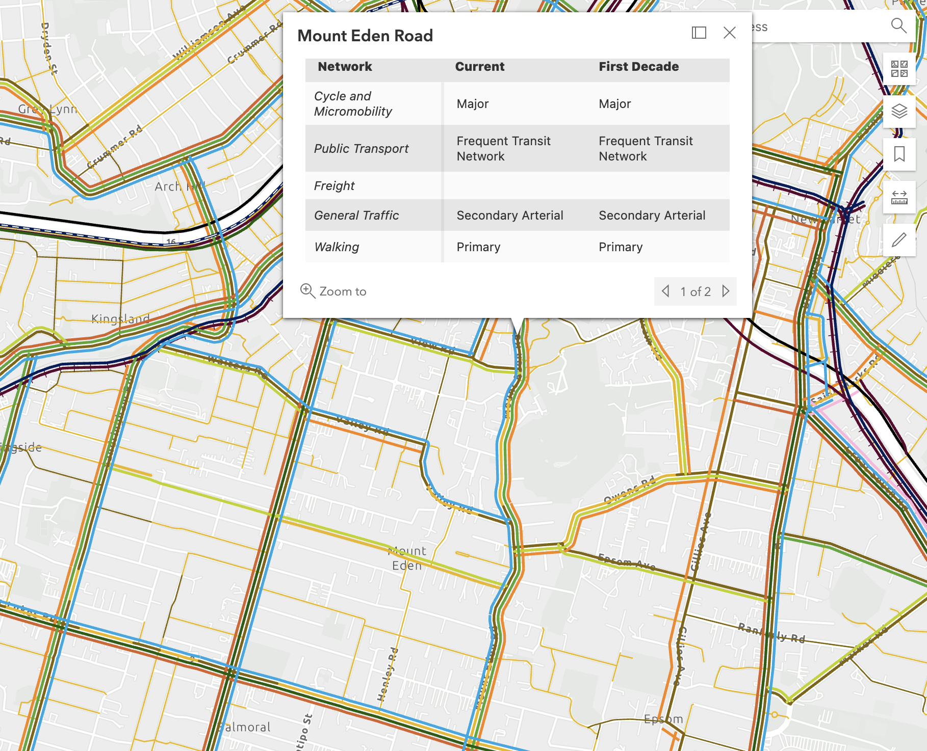
Mt Eden Road is also on the Frequent Transit Network for public transport, and a primary route for walking; but a secondary arterial for general traffic, as per Future Connect. Lots to achieve here, what and who to prioritise?
And crucially, AT’s system analysis for safety reveals it’s at the highest level of risk, both collectively and for active road users (i.e. people walking, cycling, scooting, and using mobility aids). So you would think their safety would be top priority here.
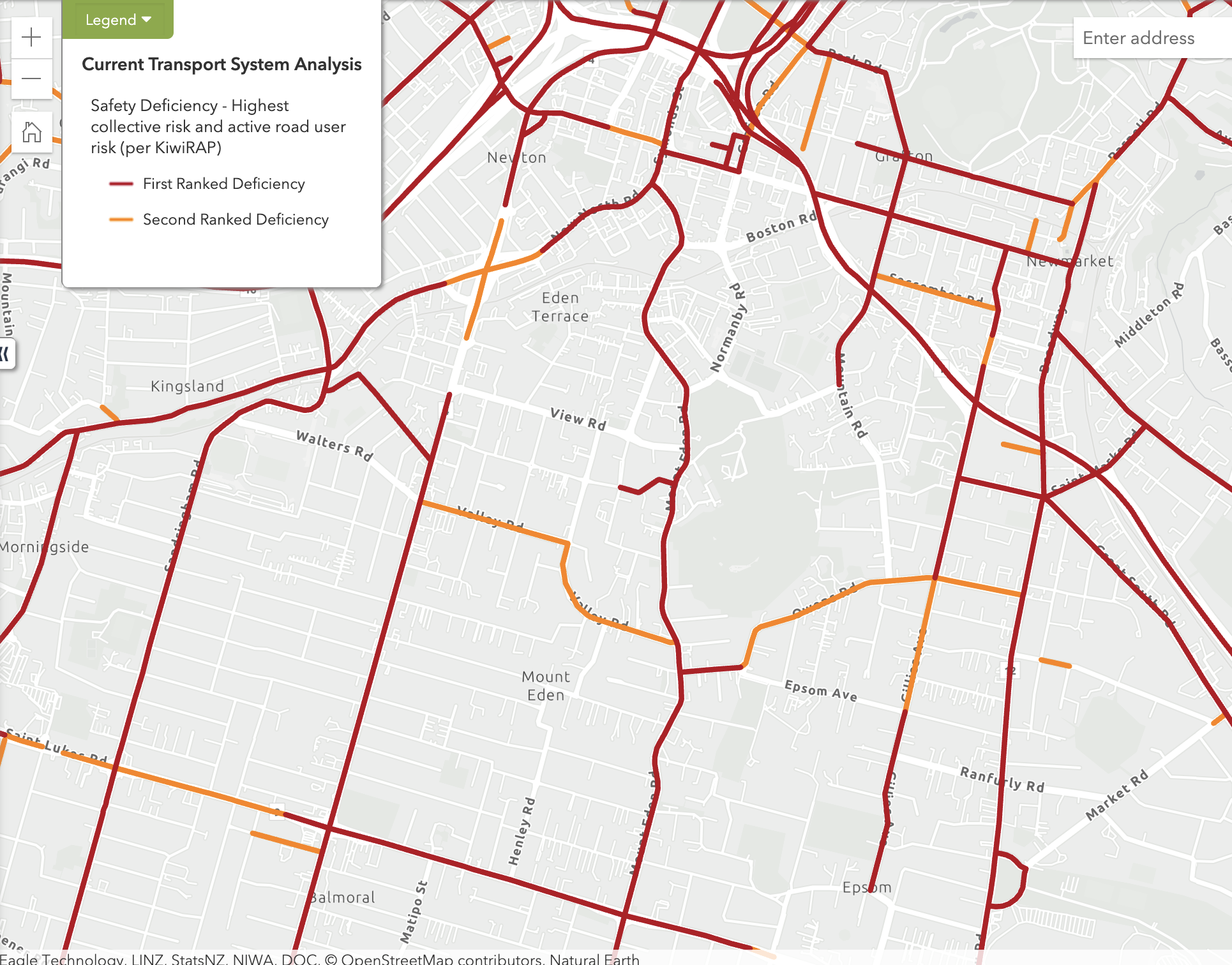
Mt Eden Road ranks as high on the safety deficiency ranking (collective risk and active road user), on AT’s Future Connect network analysis.
Auckland Transport’s plan for people riding through this intersection is to chuck them back onto the footpath with pedestrians – describing this as an “upgrade” for cycling, when it appears to be more about adding a left-turning lane for traffic into Normanby Road.
But note that the new left-turning lane is also the bus lane; leaving a straight-ahead lane for general traffic.
Auckland Transport needs to explain its rationale for proposing to remove existing bike lanes on a major cycle route – not bury the question in the fine print and hope people won’t notice.
Remember, Tāmaki Makaurau is still in a declared climate emergency, is nominally a Vision Zero city, and has a standing commitment via the Transport Emissions Reduction Pathway to “supercharge walking and cycling”.
Our question: Is this really the best AT can do to optimise this route for the 30,000 journeys every day? How does deleting bike lanes to add a lane for through-traffic “make better use of the space already available on the road”?
Remuera Road
See the project page for full explanations, and the design plans here. Here’s the problem to be solved, as AT sees it:
If you travel along Remuera Road, you know how busy it can get, especially at peak times. It is a key route connecting central Auckland to the city centre and surrounding suburbs.
Around 26,000 people travel this road every day. During the weekday rush, up to 2,400 of us are travelling in the peak direction every hour. That includes up to 40 buses – many of them for the popular 75 route – packed with people heading to work, school, shops, or wherever they need to be.
As demand has increased, delays have become more frequent, particularly between existing T3 transit lanes, at busy intersections, and where parked vehicles or turning traffic slows movement.
The proposed improvements include extending and linking the existing T3 lanes along Remuera Rd, and restricting right turns into Omahu Rd on weekday afternoons (4pm to 7pm).
Plus, and you might spot a theme here – emphasis added:
- some “streamlining” of lane markings, where drivers currently have to manoeuvre around parked vehicles
- yellow no-stopping lines to “free up space for queuing and reduce traffic bottlenecks created by parked cars.”
AT also proposes removing three bus stops, as nearby stops are close enough to retain an appropriate level of service:
- both Saint Marks Rd bus stops (IDs 7404 and 7405), and the Lochiel Rd bus stop (ID 7416).
And two “safety improvements at key locations”:
- a central island on Remuera Rd near Tahora Ave
- high-friction surfacing near Portland Rd.
Unfortunately, that’s it for active modes – although brave people on bikes can continue to use the T3 lane, along with buses and general vehicles containing two or more passengers.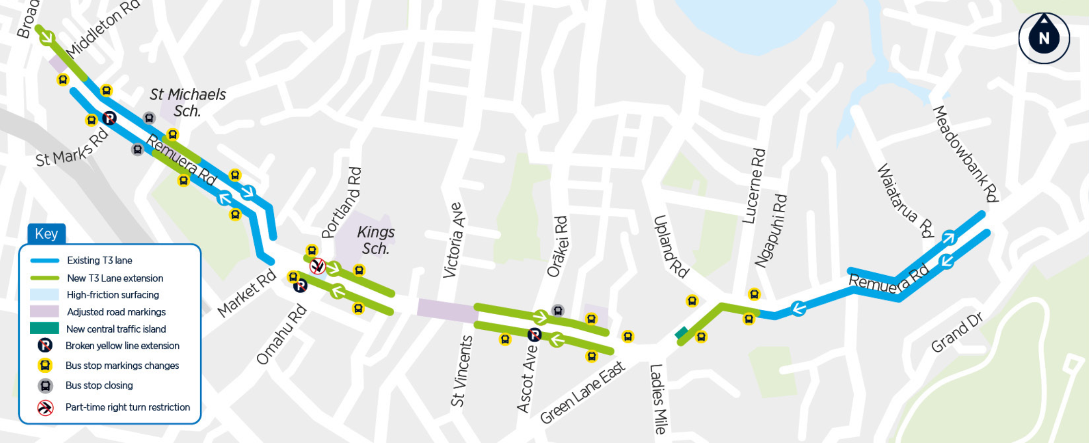
Our question: Is this really the best Auckland Transport can do to optimise the route for all 26,000 people “heading to work, school, shops, or wherever they need to be”?
Note that Remuera Rd is both a “Regional Route” and a “Major Route” on the strategic network for cycling and micromobility:
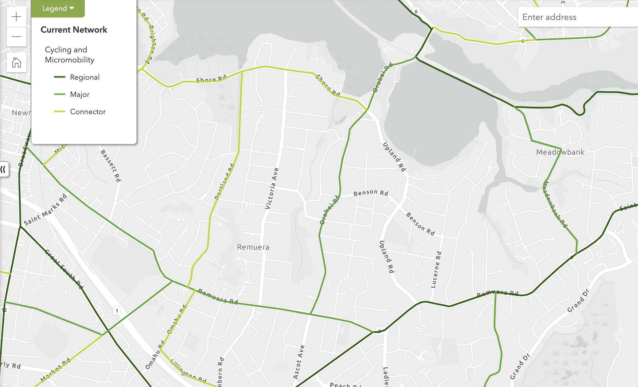
Remuera Road on the Strategic Network for Cycling and Micromobility, as per Auckland Transport’s Future Connect planning tool.
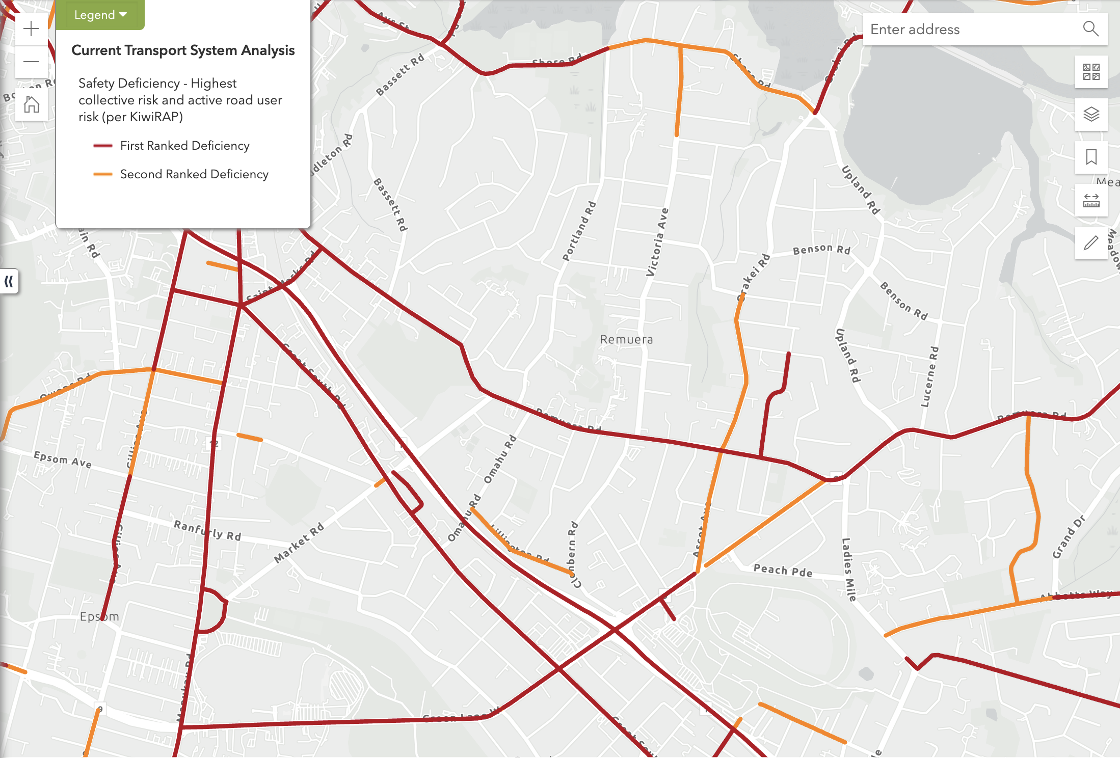
Remuera Road is also top priority for fixing the safety deficiencies for collective risk, and for active modes.
Sandringham Road
See project page for full explanations, and see design plans here. Here’s the problem to be solved:
More than 15,000 people use the road every day to get to work, school, shops and other destinations, whether by bus, car, bike or on foot.
As demand has increased, delays have become more common, particularly where existing bus lanes end and buses must merge back into general traffic.
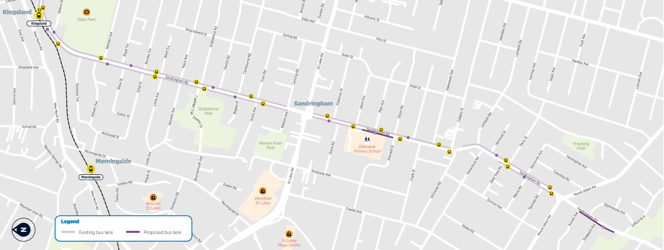
On closer inspection, AT’s proposal here is pretty minimal: two new short sections of northbound (citybound) bus lane, operating on weekdays from 7am – 10am (the dark purple lines on the map below):
- extending the bus lane from Gifford Avenue to Aurora Avenue
- connecting the existing bus lane between Shorwell Street and Edendale School
- updating lane markings in these new sections to ensure buses have enough room to move with the rest of the traffic
AT says these small changes will save around two minutes (for people on buses):
With these changes, we estimate customers will save about two minutes’ time on their journey. If you multiply that by the thousands who travel along this main road each morning, it adds up to significant overall travel time savings across the network.
 Our question: Is this really the best Auckland Transport can do to optimise the route for the 15,000 people who use this road every day – “whether by bus, car, bike or on foot” – to “get to work, school, shops and other destinations”?
And yes, Sandringham Rd is a also “Major Route” on the strategic network for cycling and micromobility:
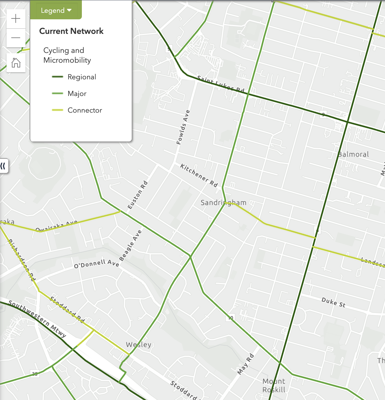
Sandringham Road on the Strategic Network for Cycling and Micromobility, as per Auckland Transport’s Future Connect planning tool.
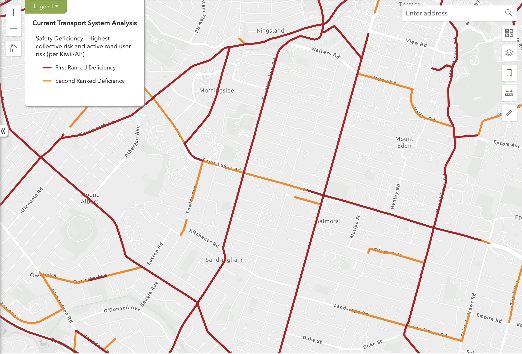
Sandringham Road is also deficient for safety – at highest priority, both collectively and for active modes.
Have your say by Sunday 23 August
You may have other local observations about the merits of these plans: by all means, share them in the comments.
To be clear: we support the intention to streamline bus travel on arterial routes. We just don’t think it should miss opportunities for – and certainly shouldn’t come at the expense of – people walking and cycling. Especially when those are the modes most urgently in need of safety improvements, and when they’re also the essential complement to public transport.
If Auckland Transport means what it says about “safer, easier and more reliable journeys”, that has to be true for everyone in this picture. Kids getting to school by bike, people cycle-commuting to work or to catch trains, people walking, running, scooting to catch a bus, visitors to our city exploring on wheels – all of us.
Plus, if parked vehicles on important multi-modal arterial routes are interrupting smoother, safer journeys… surely there are more obvious ways to fix that problem than shifting lanes around.
Check out the proposals and plans and add your feedback via this survey form before Sunday 23 August.
Note: if you want to comment specifically on the proposed removal of bike lanes at the Mt Eden Rd/ Normanby Rd intersection, look for the page in the survey titled “Upgrades to Normanby Road and Puka Street intersection”.

 Processing...
not just Mount Eden Road – AT is also secretly removing cycle lanes from Lake Road, without even mentioning it in the consultation: https://at.govt.nz/projects-and-initiatives/improving-the-belmont-shops-intersection
for Lake Road it’s even worse, there’s no shared path to replace the cycle lanes….
The optimisation team is Auckland City Council’s old traffic engineering team. They are clueless. It’s all about moving cars disguised as optimising
Clueless leadership, then.
I am not sure they are removing any cycle lanes. I go through the Belmont intersection every day and there ahve never been cycle lanes there. They stop at the road turning into the Rose Centre.
However, what is super disappointing is that there are no new provisions for cycling in this redesign. It would be quite easy to provide some way for cyclists to go through near the shops on to Lake Road. Right now, this is pretty much the most dangerous part of my commute from Takapuna.
It’s unprofessional and incompetent, AT. Are you deliberately tying up the efforts of active modes advocates? They should not have to fight for long established, evidence-based planning.
You’re refusing to allocate space away from driving towards active modes – proving you still don’t understand that this is THE most competent way to transform the networks to liveable, low carbon, safe, smooth-flooring and accessible.
Or you do understand, but Big Auto and Big Road Construction are your masters.
“Incompetent” or “disinegnuous”?
Not mentioning removing protected cycle lanes while presenting shared paths as an improvement is simply not straight up.
Thank you for this analysis!
I had a quick read when I received the email and already responded, making clear that I was extremely disappointed in the lack of upgrades for walking and cycling. This area (in fact most of the central isthmus) is extremely challenging to navigate by bike, to the point that when we go the Mount Eden as a family, we take the car.
I hate doing that, but I also don’t want to expose my two young children to two lanes of motorised traffic thankyouverymuch.
This is extremely frustrating from AT. This area is critical to get right, and as anyone who has driven to Mount Eden on the weekend will know, the parked cars in the village ARE the bottleneck. Traffic flows quite freely once you’re past the queue either side, so anything that doesn’t remove them is not going to achieve anything.
Gah.
I also put through my feedback last night requesting the bus lanes go through the village, and also operate in counter peak direction. Northbound into Mt Eden also crawls in the evening.
Surely they have some data to work out which routes slow down compared to off peak and where the bottlenecks are…
I didn’t realise they were removing the bike lanes 🙁
Is there any firm evidence to suggest that T2 and T3 lanes actually materially change any behaviour? Or do they just benefit people on the school run who were always going to have that number of people anyway? As in, peer reviewed articles.
If they went to pure bus lanes on Remuera Rd would they get some significant time and reliability benefits?
Also, I’d expect no parked vehicles at any time on an arterial road. If this is implemented without full broken yellow lines then we have failed.
Oh your last point this seems to be a major issue AT are unwilling to accept needs to change. How can a major arterial road have on street parking? Either it’s not an arterial route or they have decided that actually on street parking is more important than smooth traffic flow.
On that last point AT seems very confused. How can a major arterial route have on street parking? Either it’s not that arterial or AT need to admit they prioritise parking over moving.
The website was acting up, didn’t mean to post twice!
Argh – more cars faster. No carpark left behind.
Mods – feel free to remove – the following is an AI answer, which explained much for me. I asked why are we seeing removal of infrastructure, read your article, and questions around network benchmarking for walking and cycling infrastructure. Apparently auckland is 82nd out of 84 peer cities for intersection density and pedestrian friendlyness. I will be submitting by 23 August regardless.
[As per the commenter’s suggestion, we’ve removed most of the AI answer – largely for length but also for containing some inaccuracies. However, we’ve left an introductory paragraph and the two concluding paragraphs, as potentially useful for discussion and also for illustrating the issues with this kind of summary]
[AI generated content] AT is required to deliver on multiple, often conflicting goals. They must reduce transport emissions, which requires promoting active transport. They must achieve Vision Zero, which requires safer infrastructure for vulnerable users. They must also improve traffic flow, which is often interpreted as prioritizing cars. When these goals collide, and budgets are tight, AT has consistently defaulted to the path of least political resistance, which is prioritizing cars.
[…]
The regression seen in these proposals is not a random occurrence. It is the logical outcome of political opposition from both central and local government, funding cuts that prioritize roads over active transport, institutional timidity at Auckland Transport in the face of pressure, and physical constraints on road space that are resolved in favor of cars.
Until these underlying drivers change, through political leadership, sustained funding, and a clear institutional commitment, Auckland will continue to make decisions that entrench its position at the bottom of global walkability and cycling rankings. The Mt Eden Rd proposal is simply the latest example of this trend, not an exception to it. [end of AI generated content]
Very good.
Key bit there being: “They must also improve traffic flow, which is often interpreted as prioritizing cars.”
The interpretation is wrong, because it’s short term and hyper-local.
Even if improving traffic flow (long term) was your only goal, you’d still be reallocating space from traffic to active modes. Because road reallocation reduces traffic volumes, there’s a net benefit to all modes, over the whole network.
AT can counter all the political pressure with this, if they were only bolder about explaining it.
thanks mod – nicely done.
It’s disappointing to see in some of these villages like Mt Eden or Dominion Road, on street parking on the main road causes traffic for thousands of people.
Sometimes, like in the case of Mt Eden Village, 5 or 6 cars parked on the side of the road can cause long queues and buses, even at off peak times, spend 5 extra mins waiting to get through the village. People who frequent the Village will know well that there is loads of street parking around the back and on the side roads.
Amazing, isn’t it. Put in a cycle lane and people act like the sky is falling in because car journeys are (apparently) slowed down.
Same result from allowing parking on arterials? Nothing to see here…..
Absolutely the same applies on Remuera Rd – at several points, busses and all other vehicles have to merge into one lane to get around parked cars. AT even note this in their consultation documents, but the solution isn’t to install broken yellow lines to stop this obstructive parking, it’s to change the lane configuration so that, for example, at an intersection one lane becomes a left-turn only lane, so the two lanes aren’t merging across the intersection to get around the two parked cars that are inconveniencing hundreds of other vehicles.
And again, through town centres (both Remuera and Upland Rd), on-street parking is retained at all cost, despite the existence of plenty of on and off-street parking nearby (especially at Upland Rd).
And that’s even before we start on the lack of provision for the active modes we should be encouraging!
There is a silver lining to keeping the parking: a full four-lane arterial bisects a village, and forces a slowdown of traffic flowing through the village. If they removed the parking then it’d turn places like Mt Eden village into Broadway – just as clogged yet somehow more hostile for pedestrians.
As pointed out at an Auckland Conversation event, the past one hundred years has been dominated by planners dividing humans by method of transport.
Watercare has to divide humans by method of output, to not impact output by nature.
We cannot continue to create social division like this. We need to insist on social cohesion.
It is not bikes versus Busways, it is not pedestrians versus SUVs. It is network efficiency. The most inefficient vehicle on the network is the privately owned car. It sits idle for most if its life, often occupying public space, and causing death and destruction every where it goes.
Bikes are largely harmless. Yes, big dudes on bikes can be a little bit physically imposing, but they are not dangerous like a person sitting in a metal box with wheels.
Bike Auckland has been stripped of much of its power by Auckland Transport, and now Auckland Transport wants to undo so much that was fought for by previous iterations of activism.
The CRL connnects best with BIKES. Trains are designed to carry bikes. Bikeways should be the premier part of our transport network now.
Desley’s Way will soon be finished, and you will be able to bike from Glen Innes to Tamaki Drive.
Maangere Bridge is bike paradise, and has the most beautiful bridge yet constructed in Taamaki Makaurau to connect it to Onehunga Train Station.
Let us take a breath, and let the CRL open, before we make more changes to our transit network.
Let’s see what the CRL creates, and build capacity to take advantage of this great piece of infrastructure.
We built the harbour bridge, then ordered extra bridge from Japan, to create what we have now. It is ugly, functional like an engineer’s wet dream, but ugly for anyone that believes in aesthetic appearance.
AT has been ruining our city since its inception. BACK OFF and let us experience our city with a metro, then start planning other time wasting experiences in poo piping humans.
bah humbug
The hardest part of owning a car, is parking it.
In cities, parking a car is a nightmare.
I live in a small town of about 4,500 people. There are no parking meters, no parking buildings, and only a few 10 minute parking restrictions that are not enforced because there is no one employed to enforce them.
As I am very close to town, I rarely use the car, as I can walk to either of the two supermarkets in about 10 to 12 minutes.
Also there is no bus service, but two small taxi companies, so for those without a car, mostly older pensioners etc, they can get their groceries home by ringing a cab. In fact I think many walk in, and cab home.
Folk in cities can do no better than considering a move to smaller towns. There are jobs begging in some cases, and a recent new industry needs 120 workers for well paid jobs in our area.
AI can only summarise what it can Learn. It will pick up what common public opinion is when that opinion recognises truths about congestion and true optimisation.
It does pick up that you can only spend what the purse-holders let you have.
It would be good to see the *affordable* improvements that anyone can suggest for these proposals.
Removing parking needs to be accepted by the people who park.
Removing cycling is hardly likely to be accepted as a good idea by any who bike, walk, catch buses or would like to be able to.
You’ve expressed the problem mindset perfectly.
No, removing parking does not need to be accepted by the people who park.
Car parks can be removed just like bike lanes and speed bumps can be removed
A consultation run around South Auckland would result in as many traffic lanes as possible crammed between existing kerbs.
Everything between the kerb and the property line is already de facto parking.
Everything beyond the property line doubles as a runout for our more adventurous rangatahi…
I kept waiting for this article to tell us that their is enough room in this road corridor to fit a footpath, a protected cycle lane, then a bus lane, the a general traffic lane followed by a centreline and on the other side a general traffic lane, a bus lane, a protected cycle, and a footpath.
If these road corridors aren’t wide enough to fit these three lanes on each side of the road what exactly are we complaining about with these designs. Should we build an elevated cycle lane above the bus lane?
As usual, all modes other than driving are expected to play nicely together in the left-overs.
We could let the bus /T2/bike lane run through the intersection without interruption by car turning lanes.
You can already enter special lanes to make a turn or enter a property, no foul.
We’re complaining because while any fool can decide that (cars take up so much space and slow down buses, so) there’s insufficient space for (bingo!) *cycling*, we have a right to expect better of our transport professionals:
1. They should understand that all the demands placed on our city’s car-swamped transport system are best addressed by reducing vehicle km travelled (VKT) than by continuing to focus on traffic flow.
2. They have access to all the evidence about how to reduce VKT.
3. They should have proposed low traffic neighbourhoods to flank these corridors.
4. Along these corridors, they should have proposed generous, protected cycle lanes, quality walking amenity including adequately wide footpaths and more trees, bus lanes at a few key locations where there is space or by locally reducing the width of the cycle lane and tree space, and elsewhere (which will be the majority of the length of the corridors), providing bus priority and perhaps modal filters and timed access, not bus lanes.
3. They should be communicating how to reduce VKT, using the existing results of the VKT-Reduction deliberative engagement exercise already undertaken with Aucklanders by AT and AC themselves.
Had AT done this over the last decade, the population would be far better informed, and politicians wouldn’t be able to get away with their nonsense.
This inability to rise out of their own mess is really frustrating.
Why is this consulation being run by AT – I thought their planning functions were part of Council now?
Not until October.
The ‘conundrum’ of all (most) transport projects …
*The circle of life song intensifies …
1. Get given a problem with a relatively small budget …
2. Talk to people within AT on how best to solve the problem …
3. Get differing views on how to solve the problem …
4. No extra budget to properly solve the problem …
5. Project goes no-where.
Kind of what happened with Connected Communities. Although the New North Road plan could be adapted for all the roads these proposals are looking at. Just a matter of $$$ and political will I suppose.
You forgot – populate the team with staff with active dislike of walking, cycling and public transport.
Can we please be clear
“And, for pedestrians, they’re upgrading three existing zebra crossings to signalised (push-button activated) crossings”
This is not an upgrade, this is a downgrade for pedestrians. AT only do this to RESTRICT pedestrian movements. With a zebra you cross whenever you want and traffic has to stop for the ped. With a signalized crossing, as a pedestrian you have to beg (by pushing a beg button) for the signals to change to green for you and I’m sure everyone here has experienced the massive delay between pressing that button and it turning green, with the possibility AT will continue to ‘optimise’ the signal in the future by giving pedestrians even less time.
Calling this change an upgrade is a bare-faced lie and typical of the optimisation team which is led by former old-school traffic engineers. Shame on AT for continuing to peddle this bullshit
And not to mention its bad for road traffic too, as vehicles have to stop and wait for the light to go green again well after the pedestrians have crossed. Or someone pushes the button, sees a gap in traffic and darts across while the crossing light is still red, and then 30 seconds later the traffic light goes red and traffic is stopped waiting for a ghost pedestrian.
And surely nobody actually believes that AT’s constantly vaunted Future Connect network with it’s strategic corridors are anything more than meaningless lines on a map and an AT middle manager’s vanity project
The one question I have?
Where on earth is there the space for active modes on these corridors?
Bus lanes and T3 lanes are much much better to cycle in than GV lanes.
It’s the best we are gonna get on these corridors without widening them in most cases…
I consider this a win for cycling bar that one intersection. But with that fix the rest is a win.
Every single arterial in Auckland has a wide median strip for reasons only AT can explain
Each one of these can be removed to allow protected cycle lanes on each side
Why on earth would anyone make space for people to drive cars (which are very large), and not make space for them to ride bicycles (which are very small)? And no, very few people consider sharing with buses and turning cars to be safe.
Because driving takes up so much public space, we need to consciously provide for all the other ways of getting around first, and let driving take whatever is left. Otherwise it’ll continue to eat up the city.
There is no space in most sections of these corridors? Unless you wanna remove GV access altogether?
There is no wide median on these roads in most sections.
Im all for removing parkign and making the SVL 24/7/7 but there is no space for cycle lane
There’s space for goods vehicles. There’s space for everyone! And for everyone to be safe, including those on bikes, in their own lanes.
Of course, some people will need to leave their cars at home.
It’s backwards, and certainly not ok, to deprive safe access for kids and other non drivers, when everyone can easily be accommodated with a bit of care.
Since the problem is that cars take too much space, the solution is to take space from cars.
“we estimate customers will save about two minutes’ time on their journey”
At the going rate, central government should contribute about $500m to this, right?
If someone decided to prioritize bicycling, you could be writing this exact same post, but titled “but not at the cost of public transport”.
A lot of these corridors are 20m wide (or, presumably one chain), and that is too narrow to fit everything. We should either show viable cross sections or shut up.
The secret sauce of Dutch bike lanes and other safe street design for arterials is the 50m or so wide corridors. Which we are not going to get unless we’re OK with stuff like demolish one side of the full 5km of Mount Eden road.
https://www.google.com/maps/@52.0717024,5.0901929,45a,35y,50.83h,79.28t/data=!3m1!1e3?entry=ttu&g_ep=EgoyMDI2MDgxOS4wIKXMDSoASAFQAw%3D%3D
If you get rid of the flush median you can about squeeze in uphill bike lanes, and share the bus lane on downhill sections – similar to what Wellington does, but that’s a compromise solution that doesn’t really make anyone happy.
Realistically you have to split purposes on arterials like this – if Dominion Rd is a bus corridor, then Mt Eden Rd can prioritise bikes and Manukau Rd get to handle the car traffic, etc. There just isn’t room for anything else.
The street network is too sparse for that, there is already more than a kilometre between two routes. If you want a usable bus network it has to go on every of those arterials.
Basically AT ‘should’ implement their consultation drawings for New North Road on all these key bus routes.
Not gonna lie, I use the Mt Eden Rd–Normanby Rd intersection by bus every day and have never seen a cyclist there in the few years I’ve used it. If they add a bus lane through the intersection, I think the citybound bus lane should be physically separated from the rest of the intersection—for example, with a kerb/island that prevents cars from entering or queuing in it. The pedestrian crossing could also be split onto a refuge island, so pedestrian traffic signals don’t apply to the bus. That would effectively give buses their own protected path straight through the intersection, meaning they wouldn’t need to wait for the normal traffic lights at all.