It’s been two months, but today the Auckland Transport board meet again. There’s a lot on the agenda so I can’t cover it all in this post but here are some of the highlights from their regular board papers. The open session starts at 11am and can be watched on this Teams link.
Closed Agenda
Typically the closed agenda is where the most interesting items are but there’s not a huge amount this time. Here’s what stood out.
- Conversation re Road Pricing with Tauranga City Commissioners
Items for Approval
- Wiri EMU Depot Extension Stabling Yard II
- Climate Change and Sustainability – Future Governance Approach
Items for Noting
- Auckland Light Rail Update
- Tamaki Makaurau Joint Transport Plan – Progress and Key Risks
Business Report
Below are some of the items that stood out from the regular business report.
Vulnerable Road Users Programme
AT say there are 63 projects on the programme for delivery this financial year, with 37 completed and 14 under construction. They say the remaining 12 are due to start before the end of June.

Examples of projects from the programme
Bus Lane Enforcement
AT are continuing to roll out CCTV based bus lane enforcement on more streets. If only they could be this effective with other enforcement programmes.
- Two inbound and two outbound bus lane zones on Dominion Road have been converted from manual to Closed Circuit Television (CCTV) enforcement. Warnings have been issued since1 May 2023, and live enforcement is planned to commence on 22 May. The operational time is 7-10am and 4-7pm.
- Three inbound bus lane zones on Mt Wellington Highway have been converted from manual to CCTV enforcement. Warnings have been issued since 24 April and live enforcement is planned to commence on 8 May. This is a 24-hour bus lane.
- Three inbound and one outbound bus lane zones on Pah Road have been converted from manual to CCTV enforcement. Warnings have been issued since 24 April and live enforcement is planned to commence on 8 May. This is a 24-hour bus lane.
Parking Priorities
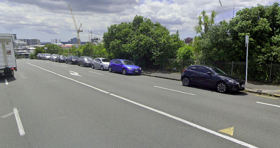
There has long been an odd bubble of about 10 free on-street parking on Alex Evans St. It’s odd because all of on-street parking on all of the nearby streets is managed by paid parking. AT have now changed this.
To improve parking turnover and address commuter type use of parking at City Centre fringe, AT introduced paid parking restrictions on currently unrestricted on-street parking spaces on Alex Evans Street. It will be operational from 9am to 6pm Monday to Friday after the existing clearway restriction (7am-9am) finishes. The tariff is set at $1 per hour for the first two hours and $2 per hour thereafter.
While the change is minor, it is a good example of how AT often focus on maintaining the status quo. The site is the primary route for connecting between Mt Eden Rd/Symonds St and cycleways like Grafton Gully and Lightpath. Simply removing the spaces and turning them into a cycleway should have been an easy and sensible change to make. The route is even on ATs long term plans for having a cycleway added.
Employer Subsidised HOP travel
I’ve long suggested that AT should offer an easy way for employers to be able to offer subsidised PT options and the removal of Fringe Benefit Tax from PT and active modes earlier this year makes it even more needed. The good news is AT are now working on it.
The cross functional squad made some good progress in April, culminating in panel approval to move forward on the development of a software solution which will enable the product to be offered at scale. Through our Travelwise programme we continue to hear from employers who are keen to offer their staff a PT subsidy, particularly since the fringe benefit tax rules were changed in April. The team will be gearing up to sign up new businesses later in the year once the software solution is ready.
No PT Satisfaction
Completely unsurprisingly given the issues PT users have had to endure, satisfaction with the network reached record low levels in March and was not much better in April.
After reaching an all-time low last month, overall satisfaction saw improvements this month (41%, +5). We have arrested the decline in system satisfaction with a 1-point improvement to 23%. Reported disruptions reached its highest point last month. This month, we see a 6-point decrease (48%).
Despite improvements overall, reliability issues continue to erode customer trust and confidence in PT.
A one month reprieve from record lows is hardly a time for patting themselves on the back and claiming they’ve “arrested the decline”. It could well just be a small plateau before the next plunge. This also suggests than around half of all PT trips have faced disruption.

Unconnected Communities
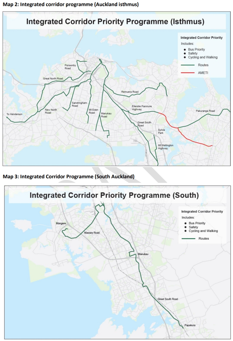
Auckland Transport have quietly abandoned one of their flagship projects, one which was meant to deliver walking, cycling and PT improvements along a number of corridors in the region. Connected Communities (originally known as Integrated Corridors) is a prime example of a rotten process that a broken organization defaults to. It was often referred to by advocates (and some AT staff) as ConJob because it’s being running for nearly 5 years, paid out tens of millions to consultants but hasn’t delivered a single street improvement – it’s even stopped other projects from making improvements if they’re even remotely close one of these corridors. I still recall a stakeholder meeting in early 2020 where a representative for people with disabilities noted that he was blind but even he could see their approach was not going to work.
New North Rd was the only one of these corridors that they reached the consultation stage on and in some of the scenarios even suggested removing existing bike lanes.
We’ll likely have more to say about this programme and it’s failure in future posts.
Our Connected Communities programme was established with the intention of optimising key transport corridors across the region with a focus on getting the most out of the existing infrastructure and developing solutions with local boards and the community. The programme was designed to develop solutions that addressed the needs of all modes while taking a dig once approach to minimise overall cost and disruption.
With changes to our funding context, these types of comprehensive solutions are no longer affordable in the short to medium term given other competing priorities. Accordingly, the Connected Communities programme, in its current form, has been stopped.
The project workstreams that make up the programme have been progressed to suitable hold points to allow for projects or elements of projects to be progressed in future work packages.
A communication plan is being developed to communicate the decision and impacts to local boards, communities and other stakeholders.
The Connected Communities programme also established a number of new approaches which will be applied to the development of future solutions for the transport system.
There remains however, a need to develop viable solutions that optimise our corridors, ensure they most effectively meet the needs of our current and future customers across all modes and that align with the Letter of Expectations for the next three years. We are working to determine the best way forward that will enable us to deliver solutions quickly within our funding parameters.
Dynamic Lanes
The Mayor has been really keen on the idea of dynamic lanes, especially to improve bus priority. AT say:
The project team have investigated 180 locations across the Auckland region to understand their suitability for a dynamic lane solution. The locations were evaluated using the following criteria: available road width, downstream capacity, difficulty/risk/cost of implementation and existing road corridor could be utilised without widening or significant civil works. Out of 24 potential sites identified, seven sites have the best combination of travel time benefits, ease of constructability and delivery. AT will evaluate which sites are suitable to be progressed to detail design and implementation, following consultation later in the year.
Last year AT were looking at using a dynamic lane as a way to provide bus priority on Maioro Rd at peak times. It seems that due to opposition by local residents to the removal of the painted median to enable it, AT are backing down and are now looking at just T2 lanes are unlikely to deliver a lot of bus speed/reliability improvements.
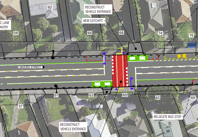
One of the old plans for Maioro with dynamic car lanes in order to provide full bus lanes.
Parking Strategy
AT’s 2015 parking strategy was good, with one major issue, AT did nothing to implement it. Last year, instead of trying to implement it, AT’s strategy team decided they needed to rewrite it and from scratch and go through a full consultation process – giving anti-change types another chance to oppose it, and oppose it they did.
AT have made some changes to the strategy and are now looking for the board to approve it.
There are a couple of key changes to what was originally proposed:
Changes have been made to address concerns, including: the proposed removal of the planned charge on all park and ride users; cutting back the areas where proactive parking management is planned; greater consideration of impacts on local business (and their mitigation); and a stronger role for local boards in the development of parking management plans.
It appears we now have a weaker parking strategy than we did in 2015.
For park and ride, they’ve come up a complicated approach
Park and ride management is one of the key contentious points in the Strategy. Policy direction for over a decade has been to price park and ride to manage demand, though it has almost never been implemented. During consultation, the proposal to implement this policy was met with significant opposition. Submitters also voiced concern that park and ride doesn’t work for them because it fills up early. Between customer, expert and political views on how best to manage park and ride; we do not have unanimous agreement. Therefore, our proposal is to develop a mechanism to charge users who park and don’t ride, and a system to allocate some spaces at each site for paid, pre-booked use, so that people who want to travel later than 7:30am can use park and ride. We believe pursuing this approach will address key customer pain in this area and will test technology and openness to pay. We can then review and consider any future policy changes following a period of operation. This approach was broadly agreed on by Councillors at the Transport and Infrastructure Committee (TIC) workshop in April 2023.
The council’s Transport Strategy Team even suggested a much cleaner solution.
The Transport Strategy Team believes there is sufficient rationale to retain a policy that introduces charges for Park and Ride (PnR) sites where there is excess demand and parking often becomes unavailable from early in the morning. Those who use the public transport should receive a discount or rebate on their HOP card when they tag on, to reinforce that the price is intended to eliminate inappropriate use of PnR sites as well as demand management. We believe this is more efficient, equitable and simple to administer than any designated premium area for pre-booked parking.
In that document they also call out AT for few other things too, such as poor communication of why and how trade-offs around parking are needed.
There are a number of other interesting papers that I will look to cover in additional posts.

 Processing...
Look at that beautiful cycleway network…that will not get built, despite all the near misses and deaths that occur, AT will reprioritise to outcrys of fixing potholes (not to say that repairing damage from natural disasters is not important). Damn you Wayne Brown.
+1000
And damn you Auckland Transport
Anyone looking for ‘improvement’ at AT with the appointment of Raveen and Henare as directors, should remember Raven’s legacy at the helm of Watercare. They won’t have any positive effect and like Dean are simply place holders until a complete cultural change, which will also require a new mayor.
The demise of Connected Communities should come as no surprise,it seems to have gobbled up cash and resources for no results. Aucklanders just have to accept that raised crossings are as good as it is going to get,if you are an active mode user. The only other “project” that may gain traction is 30 kph speed limits,only by using schools as “bait” though.
The poor safety record of Auckland’s roading network,doesn’t seem to matter,l wonder whether there will be a moments silence at the start of the meeting as all those present ,reflect on another unnecessary fatality on the roading network,they manage.
Even where the 30km/hr zones have been introduced, they have been so poorly implemented as to be worthless. In my suburb, the zone is indicated only by a small speed limit sign (none of the promised road markings indicated in the consultation), placed amongst other distractions and half in a tree, such that even a year on many residents and regular visitors (not to mention the vast number of rail bus drivers!) still haven’t realised the speed limit has changed. There is no inforcement, so little has changed, bar those that haven’t realised displaying even more frustration at those complying with the change!
I strongly support this change – especially given the number of schools and kindergartens in the area, and the recent improvements to a nearby cycleway increasing the number of bikes in the road markedly – but the lack of proper execution is immensity frustrating!
Even if they’d added the road markings… all our residential roads are built for 50 kph. To actually get people to change their behaviour you need to rebuild to the speed and that means things like raised tables, cobbles, narrowing, chicanes, etc. You can see this in plenty of residential streets that still have a 50kph speed limit but are narrowed due to lots of on street parking – people slow right down.
No practical way to enforce widespread reduction of speed limits in these areas exists. And even if it did, you’re punishing people for acting in the way the system encourages. The only solution is mass rollout of infrastructure like that shown in this post from the VRU, which is being built, but very slowly and with no plans for a general expansion.
Re- “like raised tables, cobbles, narrowing, chicanes, etc.” – Ever tried to ride a bicycle, or use a mobility scooter on these abominations, or even traverse these spaces as a pedestrian, particularly in wet weather, or using a zimmer frame or walking stick? Those cobbles may look “pretty” but are dangerous for everyone except motorists. Cobbles when used on a pavement have tendency to lift if not well maintained,[and we know how much ACC and AT like doing that!] – These surfaces are trip hazards, becoming slippery and uneven causing accidents to happen. Installing these things on Public space surfaces is a stupid idea, and can only come from someone who has little to no knowledge about getting around urban spaces in anything other than a car.
Town planners and motorists seem to have been hiding under a rock for the last 30 years and seem to have little intention of waking up, regarding the use of modern modes of personal transport, which is a frightening thought considering they think they are capable of reforming our transport infrastructure. So far their result has been to get paid a lot of money, produce nothing, and leave transport and infrastructure space a battleground between pedestrians, cyclists, mobility device users, motorists, and big piles of traffic cones and rubble on the roads. Many of these spaces are only designed to cater for “pedestrians” running between the office and shop door to their cars, and occasionally after a taxi if they can find one, and motorists racing home.
Attempting to seriously use any other form of transport to get around, even walking distances, has been made difficult. We need people who actually use these spaces to be at least consulted by those designing them , not idiots who think they know what they are doing because their name is followed by lots of ‘alphabet soup’! Or someone who hates the “homeless” so they design bus shelters that do not provide shelter and park benches that are uncomfortable to sit on.
Right now town planners seem to be bent on resolving the issues by using the “stick” on motorists and businesses with very little “carrot” for anyone. The result is bad news for anyone needing to commute to work, or anywhere else with the expectation of being punctual.
To make public transport , cycling and walking a viable alternative to using private cars, public transport, cycle, pedestrian friendly infrastructure and service provision needs to be so responsive, effective, and low-cost that end users have little reason to go their own way. Right now its failing at this spectacularly.
Why do the cycleway network plans always miss out important east-west connections on the isthmus? St Lukes/Balmoral/Greenlane, Mt Albert Rd, Mt Smart Rd, Campbell Rd etc. Not everyone wants or needs to cycle into the city.
The Future Connect network plans have them. Just no money to build them.
That map is the Connected Communities corridors, not an entire cycling network. There was a Cycling SSBC component to ConCom that looked at most of the isthmus and included a full network but it’s not shown here.
North-south connections aren’t going to get built, let alone east-west.
You’re dreaming if you think they are.
Hi, according to the Agenda the meeting starts at 11am not 9am
If the mayor was so hot on dynamic lanes, will he be disappointed to hear that only seven (of the 180 investigated) will be progressed to consultation sometime later in the year? This doesn’t even mean they will eventuate and the likelihood of delivering half (3-4) of them during this mayoral tenure is probably only 50:50. The mayor and council should be demanding delivery at a much faster pace.
I’m surprised they found 7! Can anyone think of any that make sense?
I attended the meeting. The answer given was quite reasonable. It was something like:
– Some of the corridors didn’t have strong tidal flows, so it wouldn’t be a helpful change.
– Some of the corridors didn’t have sufficient space for the extra lane over a long enough distance for it to make sense.
– There might have been another practical reason I’ve forgotten.
They pointed out that the other way to achieve tidal flow is with kerbside lanes on both sides of the road being “dynamic” in a different way – switching between parking and traffic.
I imagine that AT is keen on them, because increasing VKT by pumping traffic through corridors seems to be what they’re focused on, and they certainly think the Redoubt Rd and Whangaparaoa Rd ones are great.
So I would take them at their word on this.
AT needs more 24-hour bus lanes now to complete a network to keep the buses moving at all times. Remember People on Tuesday 9th May 2023 – Auckland’s transport system was gridlock to transport & drainage issues ensuring chaos. Also, for to Introduced the dynamic lanes, The Mayor has been going on so much to improve bus priority.
How many 24/7 bus lanes are there? I can’t think of a single one.
Dominion Road? Nope.
Mt Eden Road? Nope.
Sandringham Road? Nope.
Manukau Road? Nope.
Northern and Eastern Busway. Not that it is something that can be rolled out at pace and scale without beggaring us.
Better bring back East West to beggar us instead, at least then some people can smell new Tarmac in the morning.
Symonds st, bits of park road, Wellesley st, bits of Fanshawe st, bottom of queen st….
It just read like a list of failures.
The Alex Evans St outcome sums it up – an easy win wouldn’t get any easier than that, But instead they have increased paid-parking capacity at the expense of cycling.
Whoever signed off on that is inept. Who needs plans?
Someone must have worked out it was an extra $130 per day in parking revenue – how could they say no to that!
I use Alex Evans St as an alternative to the abomination that K Rd & Upper Queen St has turned into.
– Downhill you need to fight with the cars coming off the motorway that think you are in the way and try to push you out of the way.
– Uphill there isn’t even a direct crossing. You need to go down to the NW path crossing, or somehow get on to the road and fight with cars going left. Impossible to get out through the Tim Tams anyway
Ah, but what’s so cool is that after coming up from the NW cycleway, and finding yourself on the footpath at the corner, you can simply walk your bike straight across Upper Queen St in order to continue on up Alex Evans.
Sure, there’s no signalised crossing there. Sure, it’s dangerous as hell, and you might not make it. Sure, the drivers racing up Upper Queen St will undoubtedly toot and get angry if you’re walking across their lane.
But at least it’s not illegal. The intersection of Ian MacKinnon, Alex Evans and Upper Queen is so wide that it’s more than 20m to the signalised crossing across Upper Queen St on the southern side of the intersection. You only have to use it (crossing three roads instead of one) if it’s less than 20m away.
It’s crap. Lethal infrastructure. But Auckland’s full of it.
Alex Evans used to be my secret off-peak park n’ bike when the trains are stuffed and I was still needed to actually come to the office. Haha, I’ve been waiting for that loophole to be fixed for years.
Definitely annoying that they aren’t putting in a cycleway. They wouldn’t even have to get rid of the parking if they didn’t want to because there is that second WB lane nobody needs. Biggest challenge would be getting a crossing at Upper Queen.
It would be great to see some bravery from AT on the connected communities – right now we do not see enough.
Through Glen Innes they are doing lots of work at the same time and at the end it could be great but for the next two weeks three major through roads have stop / go, traffic lights or closures in place for raised crossings.
Not to worry though as you can’t catch the train until Christmas so I have noticed a few more bikes on the cycle paths!
“It would be great to see some bravery from AT on the connected communities – right now we do not see enough.”
Connected communities was never able to be rolled out at scale, because their starting assumption very much seemed to be a “whole road rebuild”. So it was never going to be either fast OR cheap. Now it will be cost and delay only – literally less than nothing.
Big picture AT is so disappointing.
On the upside, their repair team is on point, fixing broken or damaged signage within a week of reporting. Good work, that team!
Still, I have to wonder how someone managed to run over the Belisha beacons on a central island within a Swedish table outside a school in a 30 limit. Maybe more concrete is required.
Other cycling matters:
– Re the “vulnerable road users” build outs. These are dangerous as they push cyclists into traffic. Drivers MUST pass cyclists and try to push past as they must not be held up by 2 seconds! Why can’t they have a cycle lane on the left of the build out like they do in Aussie?
– Maioro Rd is shit show. The NW path exits here and would be the perfect route for cyclists heading West. But infinitely dangerous! We need bike lanes here
They built brand new such build-outs in the bike lane on Northcote Road.
https://goo.gl/maps/GDTfXvKETRnBmMmj8
How does this keep happening? I guess that shows you the importance of proper road design standards.
It just beggars belief. Attending an AT Board meeting is watching these bad decisions all happen in real time.
If the traffic lane isn’t wide enough for a safe pass, the design guidance is that cyclists *should* be forced to take the lane (https://www.nzta.govt.nz/walking-cycling-and-public-transport/cycling/cycling-standards-and-guidance/cycling-network-guidance/designing-a-cycle-facility/between-intersections/mixed-traffic-lanes/)
It is assumed explicitly that only confident cyclists will dare to use general traffic lanes.
Maioro Street had painty sharrows on the footpaths and a decent raised table treatment on the slip lanes from Richardson Road. High quality cycling infra AT style, compare and contrast with the NZTA provision along SH20…
I think you’re missing a bit of the context of that guidance – it says don’t have “in-between” widths (where someone might be tempted to overtake unsafely). Either make mixed lanes wide enough for safe passing or narrow enough (and slow enough) for shared use – which typically means nothing wider than a 3.0m lane. But the guidance is also clear that unless you make it low-speed & low-volume (i.e. a neighbourhood greenway) then don’t expect anyone other than confident riders to use it…
Northcote Road was an old ‘economy-class’ cycle lane design. Not enough funding at the time, and plans for Northcote housing project were held up by the John Key govt. so the cycle lanes couldn’t respond to what has now been built there. A raised Zebra would not need the build-outs to shorten the crossing distance.
Other build-outs are put in to provide shorter crossing distance, plus improve visibility where removing parked cars is not accepted. Spreading the small amount of safety money over the huge number of poor crossing sites – not the best result, but all that is affordable.
But be clear – the AT Standards allow ‘claim the lane’ only for Mixed Traffic Cycling, which is reserved for low speed, low volume streets. Pinch points are to be avoided where there is no alternative cycle facility. Unfortunately, that is all too common where funding and opposition have left so much of the network waiting for better days a very unhappy situation. Safety of all users and the ability to improve later are always considered for new projects.
You have to actually check the street view to believe it — despite the ‘economy class’ they still spent the money and effort on interrupting that bike lane with this build-out.
This doesn’t look more expensive than building a small island between the driving lane and the bike lane, something that, judging from the deviation of the bike lane, should be possible. If they’re short of money I guess they can add tim tams to the bike lane so the distance where you potentially meet cars is shorter? I am just not buying this explanation.
The thing is, there’s not a small amount of safety money. AT’s purpose is to deliver a safe system. All the money AT spends needs to deliver safety.
Instead, AT continue to build using the same planning paradigm that created the problems in the first place, wasting the money on creating unsafe environments and then claiming there’s not enough to spend on safety.
“We need bike lanes here” – so easy too if they got rid of the median strip. But the few people that live on Maioro would be slightly inconvenienced turning into their driveway.
Also worth noting: what’s *not* on the agenda. The Great North Road improvements were ready to go last October, then paused (with just a handful of other multimodal projects, at Cr Mike Lee’s behest) for a post-election “stocktake”… despite years of delay, consultation and engagement and widespread community support.
The pause led to calls from dozens of organisations (schools, businesses, community groups) to proceed ASAP.
The project came back to the AT board in February… it which point, the board decided to bounce it back to Council for further input. This grew to include a detailed site visit by councillors – an unusual precedent to set.
More than one board member expressed concern about the process, and the costs of imposing further delay – but the chair reassured them it was only a matter of a few weeks.
That was three months ago. The council feedback is in, the project should be on the agenda today and it’s not.
Best case scenario: IF Great North Road finally comes back to the board in June, and IF the design is finally given the green light to go to tender… construction will finally get started at the point where this straightforward multimodal safety and climate action project should have been wrapping up.
In the interim, people have been injured on the route, and last weekend a bus stop and tree were destroyed at the spot where the Mayor had been photographed cycling on the footpath (reportedly in order to test his theory that the safety elements weren’t necessary).
I made a Twitter thread about it all over here: https://twitter.com/nzdodo/status/1662639621208166400?s=20
Are Mike Lee and Wayne Brown on the same team?
Team Fogey.
Just like most people, AT’s biggest problem seems to be having too much stock (trains and buses) and not enough space for them, on the roads nor rail lines nor even bus stations (like Onehunga that are not at all bus stations, but carparks that allow a few buses through). Leaving the city on the first 309 at 6.30am and it takes 50 minutes to get to the other side of Mangere Bridge, the same in reverse via 309 and first LS, somewhat proving that different zones of this city are treated very distinctly by Council and CCOs. And also that EVs don’t solve congestion; so the funniest part of my day is cruising past the motorway in carpark mode at 10am on the LS. I guess we will never be able to rue the day that Efeso did not become our mayor, as democracy was not functional that day. Much like the neo-liberal mess that Rodney Hide manufactured for Tamaki Makaurau. And is the former overpaid head of Watercare now high up in AT? Corruption only doesn’t exist if there is no agency to officially investigate it!!!
That tag-on discount idea for park-and-ride… aren’t there tag-on machines at the stations?
Surely that would just mean that bad-faith parkers would park then tag on using the machines and never get on a bus. It would be a further complication to combat this loophole.
Would that not then charge them for catching the bus?
Either way it sounds more complicated than it needs to be.
“The Connected Communities programme also established a number of new approaches which will be applied to the development of future solutions for the transport system.”
They have perfected how to delay improvements and they intend to repeat the process?
I worked on Connected Communities for almost 4 years, and I legitimately thought there was good intentions behind it in Auckland Transport, maybe just not at the level where it needed it? Who knows …
So much time and effort put into it, I’m bit upset it’s been abandoned. Oh well.
Never a nice feeling. Has made me cynical about organisational politics.
By the look of the photos of the “chicane’ I guess its beck to having to suc on riding on pavements!
Is there any data to suggest these park-without-riders actually exist, or take up a statistically significant number of parks? I feel like somebody forgot they were just a scapegoat :))))
The new payment approach seems so unnecessarily complicated it may just put enough people off parking and riding altogether that there won’t be contention for space anymore… hey, job well done!
I’d park and ride in the three wide open fields next door, but they’ll ticket you for that, because it’s so much better for all of us if I drove into the city
Good we are developing the employer subsidised HOP travel.
re Park & Ride
“Therefore, our proposal is to develop a mechanism to charge users who park and don’t ride, and a system to allocate some spaces at each site for paid, pre-booked use, so that people who want to travel later than 7:30am can use park and ride. ”
Yeah that seems it would be annoying for users to book if you had to do it on a daily basis. They have that pre-booked parking thing near Sylvia Park, how do people find that (I see you can book monthly)?
How good with the CCTV buslane enforcement on dominion road be against parked cars?
Chuck one at Balmoral road shops and you’d make a fortune. That spot is only clear at 17:00 once they have finished towing all the cars and then is full of parked carts again by 17:30
Can we not just empower towing companies to do it without having to be called? Let the market do it’s thing!
Seems like those pointless meetings have two purposes. One is to reverse good policies announced at previous meetings and the other is to announce new good policies (to shut up the critics) that will be reversed in the next meeting. And everyones jolly leaving the meeting because they can now cash in a big check from the taxpayer for all of their hard work… Useless