Back in late 2018 we first learnt about a programme to roll out improvements to bus priority, active modes, safety and town centre improvements to a number of key arterial corridors across the region and to help encourage mode shift. The programme was later renamed Connected Communities but the routes that are meant to be receiving these improvements are shown below and I’ve also written about it here.
![]()
Just over three years on Auckland Transport have finally launched consultation for the first of these corridors, New North Rd and part of Symonds St – the Gt North Rd improvements are also part of this programme but that project was already underway before this process kicked off.
As a quick disclaimer, I’ve been on a working group, along with a lot of others, for this project. Though it didn’t feel much like a working group – mow like a box-ticking exercise with pre-determined outcomes and not much time to even discuss them, let alone digest them.
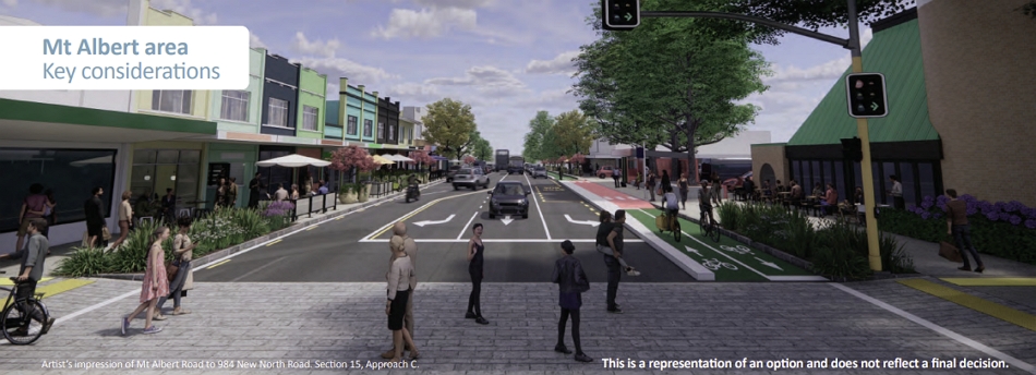
The part that AT are consulting on runs from Karangahape Rd down Symonds St, New North Rd, and along Rosebank Rd. Trying to deliver all of this within our existing corridors is understandably hard, there’s only so much space available. In response to that AT have come up with three different options for to do that, which is what they’re now consulting on. They say:
We’ve worked with our technical team to take what we’ve learnt from community engagement and identify four pillars. We used these pillars to design and develop our three approaches.
Our four pillars are:
- Safety
We want to work towards our Vision Zero goal of zero deaths and serious injuries on our roads.- Thriving town centres
We want to improve street environments and create vibrant local centres where people want to live, work, and play.- Public transport and connectivity
We want to provide better transport links between town centres along New North Road, the city centre, and future developments.- Walking and cycling connections
We want to encourage cycling by giving cyclists better options and helping them feel safer.All three approaches incorporate the pillars, just with different weightings. Your feedback will help us choose the best approach to meet our goals for a better New North Road corridor.
Approach A – Two Routes
My frustration and perhaps you could say anger at this process is mostly related to this option. It is frankly unethical for Auckland Transport to even suggest it as a potentially viable option. The proposal seeks to maximise bus priority without touching kerbs – which can get very expensive. In order to achieve that, between Morningside and Avondale they provide an ‘alternative off-corridor cycle route’.

The unethical part is that this would involve removing the existing cycle lanes through the Mt Albert Town Centre. This appears mainly focused on trying to appease some shop owners but also shows that AT think that all they need to do is to put a cycleway to an area and ‘job done’. But just like our road network, cycleways are only useful if they connect you to places. They’re not a lot of use if they just disappear and chuck cyclists onto the road with buses and cars. If we’re trying to get people out of their cars this is not the way to do it.
Other issues with this are there are also no cycling provisions for accessing St Lukes, presumably AT have taken the view that people can’t possibly ride their bike to the mall, and also no cycling provision on Rosebank Rd, I guess kids wanting to cycle to Avondale College or Intermediate will need to do so in traffic.

Approach B – Minimal kerb changes
Of the three options, this is the best of them. It keeps cycling provision on New North Rd though at the expense of not quite as substantial bus priority. It does also include a small amount of widening just west of St Lukes Rd.

Option C – Road Widening
This is the ‘if money was (almost) no object’ option and would involve widening a significant proportion of the corridor in order to fit most things in. The big downside though is that space comes at the expense of footpaths which, 60% of which would need to be narrowed. It also costs twice as much as the other options.

Interestingly, even with this option it will still see the existing bike lanes in Mt Albert changed to a single bi-directional cycleay.
No bus lanes but turning traffic options in all directions
Additional Details
A comparison of the three options is shown below. To me Approach B does seem to provide the sweet spot between improvements, disruption and cost. I suspect this is what they want the outcome to be and put the other two in, in part to test the waters. Though I’ve learnt though that when it comes to transport, you should never put in a bad option in the hope it will make people pick the right one.
They would have been better to have used Approach A as an ‘out of the box’ thinking idea with far more radical thinking, such as potentially one-waying some parts of the corridor, or even blocking general traffic through town centres with much more space given over to trees and public realm space. Basically, ideas that might get the public thinking or understanding that there are other ways we could reallocate space on the corridor.

While all options do include cycle provision, just where and how that is provided differs based on the option chosen not just for the route but also where in the corridor it is located. Concerningly, this means that based on some options, it might see cyclists having to chop and change sides of the road which isn’t going to lead to a great experience. This is shown on these road layout diagrams


You’ll that in some areas, even in the road widening scenario, there just isn’t space to provide for bus priority, such as through Kingsland. One of the options discussed for addressing bus priority in these situations is to use bus priority to get buses to traffic lights at the edge of town centres, and then hold traffic back to enable buses to jump ahead. We do have some bus advance signals at a few intersections but this would be taking it up a level.
Consultation is open until 8-April and you can find more information, including these FAQs, on AT’s website.
Over the next year AT say they’re hoping to also come up with similar consultations for the Manukau Rd, Mt Eden Rd and Ellerslie-Panmure corridors.

 Processing...
Thanks Matt. Safety staff at AT will know what I am referring to when I say that AT delays making the safety changes it is ethically and legally required to make by using excuses about the “difficult conversations that still need to be had”.
Yet here’s an example of AT making the conversations more difficult. Suggesting removing cyclelanes on stretches of high street where they are required, indeed.
It’s weird they accept things are dangerous, but will spend several years on each arterial.
While those bike lanes are about the most useless in Auckland being home to bins and pedestrian more than bikes because of the lack of network, it would be wrong to remove them as it would make the biking the shops very unsafe.
It’s ridiculous that AT can even suggest such things and talk about vision zero at the same time.
The locals in Mt Albert are still moaning about the last lot of “improvements”. I hate to think what will actually come out of this exercise. I bet I will not live to see a pedestrian crossing at the top of Mostyn St in Kingsland. We have been known to get a city bound bus to Symonds St to use the crossing there to get over New North Rd to get a bus westwards because we could not get across New North Rd at Mostyn St.
Surprisingly not terrible. Do we wait for the inevitable “oh actually the budget doesn’t reach for this after all”?
How long do we have to wait until they finally start building?
The good news is that all options make driving more difficult so where the new Plan Change 71 requires ‘Travel Planning’ for developments we can simply say we are leaving it to AT to screw up driving anywhere.
Its a refreshing change to see AT proposing to do the right thing in that regard with every single option
AT’s approach to the Connected Communities programme is that this is a competition for space between different modes. There’s a video in which they say the “original width we’re working with” is a “limitation” and the streets are “constrained, in a sense”.
None of this creates a helpful design culture. It’s better to stop focusing on the limitations. Our arterial streets are a certain size, and that’s fine. Just like a farmer’s field is a certain size. Or a classroom. Or a plaza. You shouldn’t plan the space starting out with the mindset that you’re limited. You plan it to be the best space it can be.
The only reason people think there’s not enough space is because they’re still concerned about trying to give too much priority to the mode that takes up too much space. It’s this attitude that means the consultants have ended up looking at mode share data on each section and deciding what modes to cut out – but they don’t take the most important action: reducing traffic, so that cars stop dominating the space.
AT still haven’t done the work actually required. They haven’t created a traffic circulation plan for the whole area within the motorway system, that will enable them to keep vehicle access to properties, while creating low traffic neighbourhoods and a cycling network.
And so we get this fudge with poor design. For example, bidirectional cycleways. These are fine through off street areas, but on streets they are considered bad practice, according to the international experts. See SAFE BICYCLE LANE DESIGN PRINCIPLES by the World Resources Institute.
Heidi – I would respectfully disagree on bi-directional cycleways.
1. space – they only require one buffer / separator to save space
2. they offer more width for social cycling ie; 3m and only when you encounter someone in the opposite direction does that space narrow
3. if NNR was to become a busy ‘peak’ flow corridor, then having that width for in and out bound numbers would be good.
4. cycle lanes on both side of the road still mean you have to cross the traffic lanes depending on the direction you are heading …
Yes, they save space, and that’s the reason they’re being considered. But they don’t provide access to all properties. How do you access a property on the other side of the street? Mixing with traffic or on the footpath?
Dutch arterials will often have bidirectional cycleways on both sides of the street, which harnesses all the benefits you’ve listed – but probably works best in their cycling-aware driving culture.
Best to look at the international guidance, rather than try to reinvent the wheel.
So how do the Dutch do it? They just have wider arterials.
This one, in an older part of Amsterdam, is just under 30m and has all the usual stuff like bus/tram lanes and bike lanes.
https://goo.gl/maps/nmKmS5yDKJpc3dxd9
But it doesn’t fit in almost all Auckland arterials. For some reason our arterials are not wider than our other streets. The major ones (Dominion Road, etc.) have the same width as the tiniest residential streets, at 20m.
Make the street safer to cross? – with more crossing points so if you need to cross it is easy and safe.
Yes it’s not perfect – but heck, much better than what’s currently there right?
But then you need to cross the road twice to get to them, once at the start, and once at the end. And there’s the danger
That’s unless it is connected. Like Tamaki Drive/ Quay St
Thanks but I’ll keep riding on the road…
Crossing the road depends on the direction you are travelling though right? And on what side of the road you live on?
If you’re confident on the road then that’s great – protected lanes aren’t probably for you.
So they are dead set on maintaining 50kph speed multi lane roads i a residential environment. That’s not really vision zero.
As someone that lives out West, can’t help but feel a tad irritated that there is zero time line for the Western arterials which have pretty much zero bus priority and there is a black hole of bike infrastructure west of New Lynn. As is tradition I guess.
A bike lane connecting Ash street to the Waterview shared path in all three options is great, if infuriating.
You’re right. This is not vision zero. I think the system is broken, and I’ve completely lost confidence in AT.
+1
A bit late to the party Derek.
I never had any confidence in AT at all, especially because it was a child of Stephen Joyce
“Thats not really vision zero” I agree with your sentiment, but would go further than that and suggest it is the complete opposite of vision zero. The stretch of Great North Road from Kelston Girls to New Lynn is intensifying quite quickly, and has heavy traffic. Terrace houses and Apartment buildings fronting onto a 50kph arterial with narrow footpaths and no berms is setting people up to fail. I generally avoid it on my bike, it can even feel dodgy going through there in a car sometimes!
I know what you are talking about. I live Kelsont/Glen Eden, the level of intensifying is far out here is greater most of the city. Great North Road past new Lynn to Kelson has one signaled crossing in 2 km and a couple of island’s. The foot path is insanely narrow to the point of being dangerous and the rail line forces all foot traffic along GNR. This dramaticly more oppressive that New North Road. But there is not even a time frame to look at this arterial.
I am in the same area; the state of GNR is pretty dire. Put it up for a temporary solution via Bike Auckland (I have!). The more ask, the more likelihood it may eventually get some attention.
https://www.bikeauckland.org.nz/pop-a-bike-lane-here-safersmartersooner/
Hi TimR.
Great idea. Thanks for the link.
It’s so frustrating to have so much bike infrastructure nearby, that involves so much awful unprotected street riding to access.
Since this is a primary transit corridor are all 3 proposals removing all car parks on the route?
Nope just the opposite. Car parking will be kept on the bus lanes 20 hours per work day on all three plans. See the FAQ.
https://at.govt.nz/projects-roadworks/connected-communities/new-north-road-and-symonds-street-upgrade/
Hopeless eh.
Why does AT have such a reluctance to remove car parks on major transit corridors? They complain about the limited space on the route.
No car parks left behind, is their policy. Actually it’s not this is https://at.govt.nz/about-us/transport-plans-strategies/parking-strategy/parking-strategy-policies/
Part 4
“Parking management approach
AT will manage parking on arterial roads by extending clearways, or removing parking where it:
inhibits the capacity of the road to carry more people (& goods) particularly in the peak periods, and/or,
causes significant delays to the speed and reliability of public transport on the FTN, and/or,
causes safety risks for cyclists or impedes quality improvements of the Auckland cycle network.”
They just completely disregard their own policy for some reason. Hopeless.
Because in workshops, AT staff often don’t respond with evidence to statements from the public that are based on misconceptions. So the proper conversation is never had.
Why do you need to remove parking at times buses can get through unimpeded? Unless you are a zealot of course.
It is taboo.
It would be like proposing to legalize gay marriage in 1900.
If it’s important to get a route number to allow flow between centres, it’s too important to have parking.
You’re dangerously close to seeing the real solution there miffy.
Not much positivity in here for (what I thought) were quite substantial changes to New North Road.
I’m excited to see AT engage on what could be a radical change to the current sh** state of New North Road.
I’m submitting on option B – with a big emphasis on hurry up and get to construction.
Share a thought for the poor people who have to do this work. It isn’t an exercise in cutting up the pie. It is a exercise in asking everyone to put their piece of pie back on the plate so it can be cut up again. Every option they come up with will generate hate. The only good option here is get a different job.
AT actually needs to be setting up a pie factory, with new recipes which are more popular.
Yep, you’d have to have a damn thick skin.
Getting handed a pile of requirements that objectively cant all be achieved, then having angry people telling you your design is shit. Internal politics making some “requirements” matter more than other requirements.
I worked at Auckland City Council and North Shore when I was young. I used the ‘bottom drawer’ management method. Any job where I couldn’t succeed I dropped it into my bottom drawer. When the drawer was full it was time to look for a new job.
The first mistake in many places is that we gave 80% of the pie to car drivers. Any attempt to cut up the remaining 20% is pointless.
Now here we also have a situation where we have cars, buses, bicycles and pedestrians, and there’s only enough for 3. It boils down on deciding who misses out.
Actually, there is room for all four.
The key is making sure there aren’t many cars. Cars need to be treated with proper respect, and only used sparingly. 🙂 Then there won’t be so many that they interfere with the buses, and you only need one traffic lane in each direction. Plenty of room then for the street to be a public place, and for all the people walking, enjoying the trees and raingardens, and using all the sustainable devices like bikes and scooters.
Wait you’re talking about not having bus lanes separate from car traffic?
Remember, we have this same problem on many arterials. Sandringham Road. Dominion Road. Mt Eden Road.
I don’t think there would be much room for cars there.
Yes, as per my Liveable Arterials, Auckland’s Low Traffic Neighbourhood Plan and Reducing Traffic posts. It would be a comprehensive, people-friendly, low traffic, low carbon plan for the whole city that would vastly improve access and public health.
Letting us actually be responsible parents, in light of the IPCC report, instead of this hypocritical stuff in which we pretend to care.
I can’t believe after all that effort in Mt Albert (I followed the project at the time fairly closely) that they would have to rip it all up again and potentially remove the cycleway as it stands.
Quite a lot to digest here but getting a full cycle network in Auckland is top priority.
What was delivered at Mt Albert feels like a bad compromise for all users. I’d be happy for it to be ripped up and made so it prioritises active modes. Like you say get a cycle network, not just a tick in the box (cycle lane: yes).
I actually drive more than I cycle these days (safety is a factor in this decision as I get older) so I really wish for change.
Look here AT https://www.wired.com/story/most-bike-friendly-cities-2019-copenhagenize-design-index/
You’d think the only exercise staff at AT engage in are box-ticking exercises.
So – condense all your thoughts and each provide some good feedback. What is the right speed limit on each of the parts of the road? How awful are the cycling facilities in each part of Option A and why should they be excluded from the design?
What local and wider network changes might allow getting rid of right turns?
How the heck did the Connected Communities plan fail to include any East-West route on the central part of the isthmus?? Having lived in Sandringham and worked in Onehunga, now living in Onehunga and cycling to Mt Albert fairly regularly to see family, Balmoral to get takeaways etc, the lack of cycle facilities on Mt Albert Rd or Balmoral Rd is unbelievable.
Leaving in that right turn bay at Mt Albert Town Centre for a few cars an hour is plain stupid. Most are using Allendale anyway. I few more won’t make a difference.
Removing the right turn simplifies the traffic light phasing and makes it work better for everyone else.
I suppose with where AT is headed, you could have a unidirectional cycleway in either direction, 1 lane for private vehicles either way and then using a dynamic Bus Only lane that switches directions at peak time. But that is pretty costly.
If you look at the ultra low output of AT and constant delays you do have to wonder if the city will be grid locked without a well connected cycle network for the next 20 years
AT community consultations always lead to community burnout due to their lack of transparency, delays and not going ahead with what they agreed. If you know people that work within the holy monolith of AT, which I do they will tell the same story-Politics, never ending meetings and huge teams of people “working from home” that don’t actually have to do any work. There is no accountability, therefore the public purse gets emptied without anything to show for it