The City Rail Link (CRL) is routinely described as transformational. An overused term for infrastructure projects, but one that is surely appropriate in this case – as you’d hope, given the size of the investment. $5.5b ought to get us something truly new, not just another lane and more traffic.
Clearly, the CRL itself – the physical infrastructure – is revolutionary for our country, as our first piece of permanent high-capacity underground urban transit kit.
But significant as this is, to truly achieve a transformational outcome, we can’t just build the infrastructure – we also have to operate it in the best possible way.
So this post is not about the tunnels and stations of the CRL, but about the services that will be (or could be) using them. My question: are we planning services to ensure this great investment is as transformational as it should be?
Infrastructure is a means to an end
Let’s be clear what transformational means – it means this changes everything. Something “transformational” goes beyond mere improvement; it is shape-changing.
Transformational projects are discontinuous with the past. They are not just extensions of what exists already, but a whole new thing.
Until now, the clearest example of a transformational transport project in NZ is the Auckland Harbour Bridge. The bridge significantly shifted our city from its more compact isthmus-bound shape, into a much more spatially expansive, auto-dependent suburbs-dominant pattern.
This outcome was consistent with the times, the post-war sprawl era, it was the most dramatic part of a multi-directional low density car-focused horizontal spread in all directions out from the city, following the ripping up of the tram system.
The image below illustrates this brilliantly: the road-vehicle only bridge essentially invaded the rural but proximate Shore and colonised it with the private vehicle-oriented land development we’re so familiar with today.
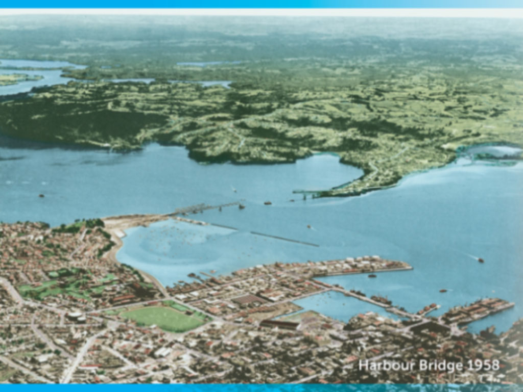
The harbour bridge under construction, about the fish the Shore, Maui-like out of the sea, into late 20thC auto-dependent suburbia.
The CRL is set to achieve a similarly dramatic shape-change, an introversion of (and complement to) the auto-dependent spread of the previous age, redirecting growth in and up.
But to achieve this, it needs to be so useful that it radically improves non-car access across the city. And it will do this by being as metro-like as possible.
At a system level, this transformation is about a phase-change from commuter rail to a metro. At the outcomes level, it’s about making movement across the city – for all sorts of trips – as seamless as possible, outside of the traffic-congestion system, for many more trips at many more times.
Enabling new patterns and opportunities, and all that this promises for economic productivity and quality of life in our biggest city.
The key elements of a metro system
What, then, are the key characteristics of a more metro-like system? Compared to other kinds of city rail a metro exhibits much greater:
- Frequency
- Legibility
- Reliability
Deliver all three, across more of the day and night, and automatically you have higher capacity.
Of course there are other important elements – like safety, comfort, and cleanliness. Still, even dirty and dangerous-feeling metros get used as long as the basics apply (looking at you, NY Subway).
So it’s really the top three that are essential to achieving the leap in ridership that will justify the cost of converting an old mixed railway to a more metro-like experience.
Design a legible, simple to use and understand system, which routinely and reliably works, and runs at a regular turn-up-and-go frequency – and you’ll meet the key transformational goals of attracting lots of new and repeat riders.
Together, these three elements will transform the system into the best option for many journeys for a growing number of potential users. And over time the proof will be in the ridership outcome: (build AND) design and operate it well, and they will come.
The three-part kaupapa
Frequency really is the magic wand. Any actual journey time includes the time you spend waiting to board, so the time you spend waiting for a train can quickly cancel out other improvements.
For example, even if the trains themselves go faster, with a lower frequency service (fewer trains per hour), people’s journeys will be longer on average than with a higher frequency service.
The minimum for a “metro” system is a 10-minute service (i.e. a train arriving every ten minutes), which gives you an average wait time of five minutes. This is generally considered to be short enough to be considered a “rapid service”, fitting the bill for a metro.
And the real magic of higher frequency trains? It’s the equivalent of moving your station a stop or two closer to your destination – simulating an actual spatial change, effectively shrinking the city and putting everyone closer to where they want to be.
Legibility of the whole system is absolutely vital, especially for a new system. To attract new riders, it must be instantly comprehensible. Maps, signs, communications, etc all must be consistent and user-focused – for all kinds of users, young, old, newbies, old hands, long-time residents and visitors alike.
The use of easy-to-remember colours, numbers and letters to describe and identify routes and vehicles is a globally proven system. The line names AT have chosen do not pass the legibility test (E-W, O-W, S-C) – they are bafflingly fiddly and artless, and incoherent with the rest of the rapid transit system.
The whole top tier network, across modes should have a single route naming system. Sydney offers a great example of consistent coding across the various modes that make up their top-tier network.
Reliability is self-explanatory. And for repeat use, and word-of-mouth vibes, it is absolutely key. Do the simple, well-communicated thing, over and over, at the best possible frequency, and it will work.
Stick to this kaupapa and you will be delivering on the transformational promise of the beautiful infrastructure.
Transfers
Are not to be feared, but optimised. Auckland’s public transport network relies on transfers – especially on bus/train transfers, as at busy stations like Panmure and New Lynn.
The transfer model is a very efficient way to expand the reach of a sparse but growing rapid transit network. It speeds up people’s journeys, so long as the transfer is clear, easy and quick.
And the key to an effective transfer system is, once again: frequency. It’s no use having buses arriving every couple of minutes to trains (see also ferries) that are only on a 15min or worse schedule. Sure, the spreadsheet might say there is a “balance of seat capacity” across an hour between the two modes given the size of the trains. But you will lose riders if the higher-order mode, the train, is so infrequent that the transfer becomes a much greater pain point on the journey than it needs to be.
Simple system design is essential to the transformation
Now, I know our network is a very limited one (only double-tracked), and not fully grade-separated (it still has many level crossings), and it’s mixed-use (shared with freight and intercity trains), and it’s interlined (different lines have to share the same track).
All these factors significantly complicate system design. But they should not alter strategic intent. These are all known features, and have been clear for the full decade the CRL has been under way. In fact, these complexities further underline the importance of keeping system design as simple as possible.
The Western Line is key
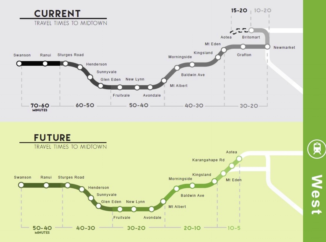
The Western Line will be the most transformed by the CRL. It’s true that the CRL will give people all over the network far better direct access across the city centre – and the Southern line has now been extended with new stations to serve future communities.
But it’s the Western Line users whose travel will improve the most significantly, with new direct access to the city centre – the highest concentration of employment, education and entertainment in the country.
In fact, it’s hard to overstate how radical a transformation this will be, especially for a swathe of the city that’s home to an already sizeable and still growing population, but that has a relatively low level of local employment and no major tertiary institutions.
How radical, you ask? Twenty minutes faster! The equivalent of picking up these suburbs and moving them twenty minutes closer to the city, offering so many people the chance to opt out of traffic congestion.
What this means is for the greatest success of the transformed network, the operating pattern should begin with a focus on delivering consistent higher frequency on the Western Line.
The new tunnels will open with a capacity to host 16 trains per hour [tph] per direction. By connecting two sides of the previous network, the CRL enables the reduction of the current three-line pattern down to two main lines. Fully half of these should be heading to and from the Western Line all day, to unlock this opportunity.
Eight trains an hour means a train every 7.5 minutes each way, on each line. Not just true turn-up-and-go, but a meaningful improvement on the current 6tph at peak and 4tph off peak. Where the two main lines overlap this means you’ll see a train every 3.45m in each direction. Now that’s a real Metro.
So, what would it take to deliver 8tph on the two main lines?
The two main constraints are competition for train slots from other rail services (passenger and freight), and slowing for road vehicles crossing the lines at level crossings at the outer reaches of the lines.
The Western Line hosts very few freight trains, currently a max of two per 24 hour period (which can and do run overnight), and no intercity services. So, as long as Auckland Transport doesn’t programme other services on the western line that are not heading to the CRL, maintaining a steady 8tph all day on this core task should be possible. Great.
The level crossings should be manageable at 8tph too. Of course, removing them would be better, and will enable even more services, but that will not be achieved in the near term.
The Eastern Line
By contrast, the Eastern Line is fully grade separated, with no level crossings, all the way to Manukau City. However, its two tracks also serve the busy and important Port of Auckland freight traffic to the inland depots, as well as a number of intercity passenger services.
Blocking out space for long slow freighters means maintaining all day 8tph on the eastern line portion is not possible, with freighters sharing the tracks in the off-peak periods.
Currently, AT is planning to pair the Western Line with the Eastern Line – running trains from one line directly through to the other.
This will limit Western Line frequency to Eastern Line maximums. In other words, there’ll be lower off-peak frequency on the Western Line to accommodate those freight train slots on the eastern.
Is this wise? When service on the Western Line is critical to the whole success of the CRL?
Especially when there is a clear alternative to this pairing?
The alternative: the Western Line can still terminate at Manukau City if it is sent via Parnell and Newmarket, rather than via the Eastern Line. As this direction reduces conflict with other services.
Moreover, this switch makes for a much clearer pattern overall:
- South through the CRL to East terminating at Ōtāhuhu
- West to Manukau City via the CRL and Parnell
- (leaving aside the Onehunga line, whose 2tph could either terminate at Britomart via Parnell, or Maungawhau NAL platforms).
See below how much clearer this plan is – the Red Line is no longer clouded in doubled-back confusion:
A more useful way to run the trains? Image credit: Jug Cerovic
The other great advantage of this pattern is that the trains on the Red Line heading east at Ōtāhuhu will have plenty of capacity for the busy stations there – including picking up all the transferring bus riders at Panmure, arriving via the expanding Eastern Busway. This is especially important if frequency is reduced to leave space for freight services.
Whereas, if the Red Line instead returns back south from Newmarket, by reversing back through the CRL, there will essentially be empty trains pouring through the CRL – even in the morning peak. That seems kind of crazy.
For comparison purposes, here is the currently available official map. It is not really clear how that Red Line operates:

Conclusions
- The CRL changes everything – which means the Model™ will be even more inaccurate about potential future demand than usual. So, do not attempt to match capacities to modelling outputs. Instead, approach the design on Metro principles, as if the whole system were brand new. In particular, expect the Western Line to be completely different.
- Capacities on the lines are constrained, which means bespoke one-seat-ride services can only be provided at the expense of frequency on the core lines. Resist the temptation! A transfer in a properly frequent system is a fine alternative, and is even likely to be better as Matt shows here.
- This is a call to design the Day One pattern on an ambitious high-uptake plan. Start out with a system shaped for success. A Metro, on the principles outlined above. Riders will use the new system in all sorts of new ways, as long as the base pattern is clear and reliable. Keep our eye on the prize: new and repeat travellers, at scale, with strong growth over time.
With metro-isation as the core strategy, we can achieve a base two-line pattern with as close to 8tph as possible on both lines through the CRL, between Papakura, Swanson, and Manukau City. (Off-peak on the Eastern Line will likely be less frequent, to make space for Ports of Auckland freight traffic).
Plan for success: simplicity, clarity, and above all else, as-high-as possible frequency.
This will give us our best shot at achieving all the promise of this potentially transformative investment.
—
Note: this post is intended as a high-altitude strategy discussion. We will follow up with a more detailed analysis of the proposed running schedule, as more information comes to light.
Greater Auckland’s work is made possible by generous donations from our readers and fans. We’re now a registered charity, so your donations are tax-deductible. If you’d like to support our work you can join our circle of supporters here.

 Processing...
Ironically the analysis of East-West capacity is backwards. The actual constraint is not the western section, but rather the eastern; hence why eastern peak overlays have to swing around to Newmarket instead of continuing to Swanson.
Very, very unlikely we see 8tph on Western line without level crossing removals.
This can’t really be the case, except in someone’s mind at AT, 8tph is possible at the peaks, when driving is also at its most intense, and therefore level crossings most conflict-producing. So what is it about then at off peak times that makes 8tph suddenly impossible?
It’s the imaginary freight trains, and that the network operator (KR) saves space for notional, possible, maybe one day, freight services by the rail logistics company (KR). The metro services owner AT seems to have internalised this as some sort of law of physics, not an unreasonable condition that should be contested.
At the very least AT should try, propose access to those unused freight slots till such a time the Marsden Link is built and even that leads to much more freight demand north.
They should make the case to KR to release them temporarily, at least until they can get the level crossings removed. As a much busier Western Line will advance that case sooner.
Then appeal to the Ministry and and Ministers, who after all have just spent a fortune radically improving the point of the Western Line in particular, only to not use it much during the day? They are probably unaware of this.
it seems to me that it should be fairly easy to demonstrate the productivity and resulting monetary gain (assuming there is one) by eliminating the hypothetical freight restrictions vs maintaining the status quo and therefore make a clear financial case for it. To your knowledge has this been done?
Not to my knowledge, like I say, it appears AT just treat this as a law of physics or something. No visible ambition to address it. Hope I’m wrong.
It’s not entirely clear who has imposed it, but there is a 12tph limit on the Western Line because of the level crossings. The 8tph in the peak direction is only achieved by reducing the counter-peak to 4tph. This then balances out to 6tph each way off-peak
It is AT, valuing car movement.
So now the prime beneficiary of the CRL is getting… fewer off directions trains than before.
Really getting the most out of this eh.
Thanks Arthur, it’s not entirely clear then why this hasn’t been questioned?
I don’t know what to tell you Patrick, except yes, this is the case. 8tph is certainly *not* possible at peaks. Even in one direction (despite that being originally the plan).
6tph is the limit on the western line. Eastern line can run much higher.
Likely due to barrier down on western line arterial roads (which also affects buses).
OIA AT!
Yes, the barrier down times for trains heading West are long at Avondale, Glen Eden due to dwell time at station being included. Maybe that will change?
That makes no sense. The eastern peak overlay swings around to Newmarket because the western section cannot handle that many trains. So it *is* the western section that is the constraint.
I do hope that with your connections/contacts you and others are able to be having these conversations with AT/AC, if often feels like those making some of the decisions are not completely au fait with how PT systems can and should work.
Yes i have.
Has a shuttle service option between Onehunga and Penrose been considered for the City Rail Link? (CRL) This shuttle option is a potential way to manage the 3.6km branch line. Xfers for the Southern line services would match up far better.
The AT rail guys got very obsessed with providing and inner west to inner south line that doesn’t go to the CRL, and want the onehunga branch to be that.
They pushed through a whole set of extra platforms at Maungawhau for it… so now they’re stuck having to run it otherwise they look foolish.
Sunk cost fallacy of course, just because you built unnecessary platforms is no reason to run unnecessary trains.
Those extra platforms would work quite well for intercity services if it helps save face. Running Te Huia to Mt Eden would work much better than the current setup at The Strand.
Agree, long been my view too. Way better than being stranded at the Strand.
Yes! Great idea, that I’ve probalby heard before on here. Makes total sense. I guess the Northern Explorer (to Auck-Wgtn train) would eventually work well into Waitemata once it’s a electric hybrid of some sort.
I think issue is the Penrose third platform location is so bad/far from platform 1 and 2 it is basically not worth bothering with a 10 minute slow train.
But the location of the Penrose third platform arises from having the line to Onehunga link at Penrose to the Southern Line facing north. If Onehunga is being served by a shuttle which terminates at Penrose the third platform could be moved.
Moving the platform would cost tens of millions and this will still be a silly/ marginal trip.
Surely it would be pretty easy and cheap to move the branch line platform at Penrose 100 metres closer to the main station.
Exactly. An Onehunga shuttle is what you do when you want to kill the line and close it. The freight bypass through Onehunga is decades away. They should be upgrading and making proper use of the Onehunga Branch Line until then. 6-car and double track is totally possible and would solve a lot of these problems, not to mention reviving the possibility of a rail link to the airport for those who want it.
I agree with what Nicholas Lee says below. I think it would probalby cost most more to double track and remove the level crossings along the Onehunga Branch Line that two rip out the current single line track and put in double track for light rail. Part of a wider network but could easily be a shuttle to Penrose to start with at way higher frequency that people would actually use it. Missed the train by 30 sec the other day so would of had a 30 min wait until the next one, so took the Southern.
Long term Onehunga Penrose should extend east and west to Panmure and New Lynn with a crosstown Light Rail line.
Honestly the naming system they went with made me so disappointed. The te reo colour name concept, T1 Kākāriki, T2 Whero, etc, imo was the obvious choice; a simple, easy to remember number system while continuing to seamlessly integrate māori culture into the PT network as a whole
So looking at this this Parnell only gets trains in one direction. Is that correct?
Both main lines are bi-directional, so no, Parnell gets trains in both directions.
However if, on AT’s map, Red Line services return south from Newmarket then Parnell will only get a south-bound service for one stop. Will need to transfer there.
But it isn’t clear what the Red Line does?
Surely it would make more sense for the Eastern Line to go all the way to Puhinui not Onehunga? Need to build those extra platforms asap
Do you mean Otahuhu?
I think there is track capacity constraints further on, which is why they’re planning on stopping them there. It’d be better to have all terminating trains in that area stop @Manukau, with 1 platform for each line.
Presuming you mean Otahuhu not Onehunga I agree.
It would mean services from Pukekohe could run express through 3 of the 4 stations on the section of the third main and still maintain high frequencies at these stations.
Sorry yes, Otahuhu, anyone going from East to the airport has to change trains over a short journey, seems sillly
Dwell time has to be part of the equation too. AT trains don’t feel anything like the metros I’ve used overseas, they are more like an antiquated regional train service that isn’t in any kind of hurry. In bigger cities the train has probably opened and closed the doors and left the station before an AT train has even opened the doors.
Yes, even Wellington’s trains have a 30 second dwell time with a train manager and NZ regulatory settings.
Long dwell times is solely for the purpose of cooking the books when it comes to train on-time arrival statistics.
Faced with either: (i) improving service outcomes; or (ii) obfustication; public bodies always choose (ii).
Hopefully the incoming rod of direct political accountability will force the feckless bureacrats at AT to smarten up their act.
Rubbish. AT’s dwell times are a function of having level boarding ramps deployed at every stop, no matter what. In other words prioritizing access to all. This is not even the only instance of that policy. Numerous operational parameters have been truncated to prioritize access for all over end-to-end trip time. That these choices cut into the performance stats that impatient able and mobile voices demand is a different problem.
Interesting analysis, and valid criticisms. To my mind, the key feature that stops the Auckland urban network supporting a true metro is that nearly all of it is an integral and essential part of both the national freight and regional passenger rail networks, sharing the same tracks, the resulting conflicts impinging on both the essential frequency and reliability characteristics (the third, legibility, being somewhat of an AT own goal).
“We will follow up with a more detailed analysis of the proposed running schedule, as more information comes to light” sounds very good, and as an aid to that the timetable that AT used for its January test is available at https://fyi.org.nz/request/33633-city-rail-link-train-timetable?nocache=incoming-139838#incoming-139838, together with accompanying notes.
Even more interesting is that this criticism of freight and passenger services having to share the rail corridor is a feature inherent to the roading network, yet it is sacrilege to criticise the trucks.
Nice work Mike ! – thanks for posting the dataset – its most interesting.
I had a quick look at it, its not a very friendly format, fixable with a bit of reformatting. Its very much a test schedule, not a useful ongoing timetable (i think)
The southern line looks like only 2 EMU’s (emu3, emu6) running for a couple of periods.
I spoke with a station dude, he said there was a lot of confusion during the trial, it didnt go so well… The spreadsheet/plan has a lot of moving parts…
I’d like to see CRL “The Movie” and thinking with a bit more messing around, it should be easy to see dots moving around network maps, even overlaying in national freight and other scheduled services if desired.
There is one other important element left off your list that will ensure the Metro System will be well supported by the community. That is SAFETY. I.e. Personal Safety for travellers using the CRL.
CCTV is an non-active deterrent only. Cameras won’t provide help to someone being attached by a group of intoxicated youths, apart from being used to prosecute the offenders afterwards. There is also no reason to believe that the Passenger Emergency Buttons (PEB) will be of any assistance.
Who will come to assist when the PEB is activated?
What is top stop the offenders from preventing someone from reaching the PEB?
I truly hope that the CRL is well patronised but this issue needs to be addressed. It should be a joint approach taken by Auckland Council, NZ Police and KiwiRail.
The article does mention safety though. However, if the system is perfectly safe but offers infrequent service, it will lose a lot of ridership.
Safety needs to be managed across the whole city, too. What is stopping “intoxicated youths” from attacking you in a shopping centre or car park? If there are no viable alternatives to getting around other than driving, how will the chances of being in a DUI-related car crash increase?
Agreed. Crime is city-wide problem.
Part of the answer could be properly fenced and monitored stations with turnstyle access only. Of course that will increase the costs initially. The other option is for Auckland Council + KiwiRail sharing security costs and putting security onboard ALL afterhours train services.
Do you think trains are unsafe at the moment? The times I have used trains in the last few years, I felt they were slow but the best form of transport in Auckland.
Auckland would benefit from dedicated transport police – a few disinterested Maori Wardens pootering about just isn’t enough.
Can we not just give our ticket police more powers and staff? Pair it with bodycams (they’re already under camera pretty much 24/7 anyway).
We don’t need yet another duplicate body, but if it’s under the police they’ll just divert the resources to other priorities.
I simply cannot understand why a every short curved line has never been built after Sylvia Park onto the line to Penrose! THEN a true inner city Circle Line would exist. At the moment, if you travel from Newmarket, to get to Sylvia Park, you have to go all the way to Otahuhu, and then change trains. Similarly, if you come from Panmure, to get to Newmarket, you have to go to Otahuhu and change trains! It simply doesn’t make sense. That very short curved linking line would create a two-way Inner Circle line removing the need to change trains!
It’s very easy to draw nice lines on a map, but operational realities are different. You are proposing adding two junctions to the network, and an extra route, which eats up capacity and creates operational dependencies (even if the junctions are grade-separated, which would make them very expensive). All for a trajectory that, given it has a significant change in direction, would serve a very limited number of trips. Such trip patterns should be served by buses, or connections/transfers. It’s not going to be close to worth the complexity.
The Circle Line in London is retained (in its current non-continuous “tadpole” shape) because the core service patterns of the District Line, Metropolitan Line, and Hammersmith and City Line do not make full use of the Inner Circle’s capacity due to their complex patterns.
The legibility issue has been compromised from the very beginning by substitution of the original station names by unrecognizable Maori names for purely woke ideological
reasons. And even for confusing reasons.
Britomart was a specific place and the name was worth preserving for historical reasons, Waitemata is the name for a whole harbour, not just part of it. Aotea was a short name and clear destination indicator, the existing Karangahape was a clear indicator without the unnecessary hyphenated appendages. Finally, Mt Eden Road is place specific rather than invoking a distant volcanic cone.
English should be the language of choice for all notices for the simple reason that 97% of New Zealanders use and understand it. And there is a good chance that visitors will understand it too. Notices in both English and Maori are an unnecessary and expensive complication and especially if Maori is put first.
For clarity double naming is especially to be avoided as it is tautology and unacceptable to competent English speakers.
So my ” School Report ” on legibility is a fail from the very beginning.
old pakeha codger using the word “woke” unironically – opinion immediately disregarded.
Go back to Facebook, gramps. At least there you’ll find fellow idiots who think an English ship named after a Greek goddess has more cultural relevance to Aotearoa New Zealand than indigenous names
Burrower would appear to be a mud- slinger and not to be competent in English with a wonderful example of tautology.
I rest my case.
You’re a funny guy Warren, let me know when you’re booked in for that stand up special – I might even show up
that’s rich coming from a racist with a phobia of new words and change
Speaking of, Warren, if you need further education:
– Aotea is the Te Reo Māori name for Great Barrier Island. It has nothing to do with central Auckland
– Karangahape should not be a single word. In Te Reo, it is a sentence: Te Karanga A Hape (the call of Hape). The hyphenation is therefore correct.
– Last time I checked, Maungawhau station was previously Mt Eden Station, not Mt Eden Road Station. So the renaming is just a literal translation from english to Te Reo.
Subway stations in New York get away with using easily forgettable and confusing numbered street station names. To regular commuters and first time users, if there’s any confusion it’s not much of a hassle to put ur destination in Google maps and that tell u which station to get off. The specific name of a station is nowhere near as important as u make it out to be
People will adapt and associate that stations name with a specific location, doesnt matter what its called, this doesn’t need to be a culture war issue
In NY all lines are a single number or letter. You’d think we’re a bit of a way off from exhausting the alphabet with our little system, or there’s the Sydney system if it is really so important to identify the mode in the name: T1, M1, B1, F1, L1 etc (Train, Metro,Bus, Ferry, Light Rail).
The station names make perfect sense to any Aucklander, they are referencing the natural environment we all rely on. Time to learn a bit about this place, its history and people!
No, it’s the names of the lines that are the issue – OW, EW and SCK
I personally wished they had kept Aotea. Te Reo and has linkages with the area (the Square, the Centre).
I kind of like “CPO” for Britomart/Waitemata – but I’m probably on my own on that one. And Te Komititanga, given the wonderful public space there now.
No one gives a crap what whiny bigots like you think is “woke” or not. Shut the hell up.
Tourists? Many don’t even speak English you utter moron. Even if they do, tourists know that sometimes, other countries speak other languages.
Sorry you’re too stupid to grasp some new words. That must be really hard for you. It must be a real struggle getting around the city as it is. Do you crap your pants going to Takapuna? Papatoetoe? Manukau?
You seem to have a problem with anger management.
It’s reflected in your inability to debate issues, rather than resorting to personal abuse.
How dare someone have a different opinion to yours.
What “issue” is being “debated” when some bigot whines about Maori names?
Sick to death of putting up with this shit. Racists should be called out as such.
This is a bad faith argument.
No one is against maori origin place names.
But lots of people are against “mana whenua” “gifting” new names to things that already had names.
If you don’t understand the difference, don’t go off your nut at someone.
2 of the stations never had names because they never existed, and Warren S is clearly arguing against Māori place names. Bad faith is right, but it’s not coming from KB
If your school report is a fail, then you might need to re-take the class
I can’t fathom why we’re doubling down on 20th-century fixed infrastructure when the genuine future of mobility is already scaling successfully right now.
Tesla’s vision-only robotaxi network is proving it works, and the numbers crush every other option — especially subsidised public transport. ARK Invest (Feb 2026) forecasts consumer fares at scale of just US$0.25 per mile (~NZ$0.42/mi or NZ$0.26/km door-to-door, on-demand, 24/7). Tesla’s own target operating cost is ~US$0.20 per mile (~NZ$0.21/km).
Now the Auckland rail reality: average subsidy of $12 per train passenger trip (on ~12 km journeys) = $1 per passenger km paid by taxpayers alone, on top of the fares we all pay. With farebox recovery sitting at only ~34%, the true total cost to the public is well over NZ$1.50 per passenger km — 5–6× more expensive than robotaxis will be.
And here’s the part no amount of clever service design can fix: most people don’t want “optimised transfers” and high-frequency trains with station walks and stopovers. They want simple, convenient A-to-B transport — summon a clean electric vehicle from their driveway straight to the destination, zero hassle, zero parking stress.
The $5.5b is already committed, but going forward let’s invest in what will actually serve the robotaxi age: strategic road tunnels to kill the worst congestion chokepoints, upgraded intersections, and Dutch-style turbo roundabouts that move massive volumes safely and cheaply without signals or land take.
The CRL is betting Auckland’s future on yesterday’s technology while the cheapest, most convenient mobility in history rolls out is the real missed opportunity. The data is crystal clear.
time to plan for true transformation.
Most people in other countries know benefits of public transport. Autonomous cars are still cars and will cause congestion. They will still pollute more. They will still occupy more space when not in use.
Elon bootlicker advocating for a Wall-e type dystopian future.
Traffic demand is very largely diurnal, from home to a destination in the morning and then in the opposite direction in the late afternoon or evening.
So autonomous cars intending to make multiple trips face making half of them empty to catch another load in the demand direction.
So twice as much on road clutter as those cars that are driven to work in the morning, stored unproductive all day to make an evening return.
The only advantage of autonomous vehicles is perhaps relinquishing storage space at desired destinations.
Simple message is don’t look to the USA for solving traffic problems.
Look elsewhere, Europe, and Asia, especially now China, who in a generation have gone from bicycle, to car, and now are embracing mass transit at a phenomenal rate. All while Americans are just continuing on just supersizing their traffic jams.
The data is crystal clear Bart, it’s time to sell your $TSLA shares. No amount of mental gymnastics can change physics, rail transport is just more energy efficient than road transport (and easier to automate)
True transformation? Using landbound cars? Why are you doubling down on 20th-century fixed infrastructure like roads and tunnels?
eVTOL is the name of the game.
https://www.youtube.com/watch?v=q6WTIayiJDo
Flying robotaxis point to point.
No more roads needed! Or any other fixed landbased structure!
And it solves navigation, since any point to point travel is really point to point, straight line! Which is of course is also the most energy and time efficient route. The cost savings and productivity this unlocks!
Now that is what I call forward thinking. And a true transformation.
(Especially for the poor pedestrians who have to be always aware of cars raining down when they crash up in the air).
I find it interesting that some commenters find it easy to dismiss public transport (the ONLY PROVEN technology which solves mass transportation) but then promote roads with cars (the technology which has the lowest cost to benefit ratio). And pull numbers out of the ether with “Tesla has proven” … they have a handful of cars in Austin which barely drive unassisted (15% of the time or so) and have according to Teslas metrics five times the number of accidents then humans, with an unknown cost; if that is the proof, then yeah, Tesla has proven that Robotaxis do not work. (Tesla has also some taxis in SF, but all of them use assisted driving.)
Electric cars DO pollute – their tyres abrade and all those polymers end up in our water
Autonomous might be the solution for first and last mile but even then, they haven’t proven themselves in densely built-up environments. For liability and insurance purposes, they will have to be super conservative, so stopping every time there is even a risk they might clash with another person, vehicle, animal etc. It’s why Musk wants US states to pay for/subsidise tunnelling, to take away the conflicts on high-demand routes.
You know, like a metro.
Maybe it will happen after the CRL is bedded in, but I think there needs to be an honest, strategic discussion about the O’ Line.
Inner west to inner city, Onehunga-Newmarket shuttle, part of Avondale-Southdown HR, replace with light rail/busway from NW busway through to southern/eastern line and also airport. There are a few options.
Worth an article, maybe?
With surface light rail apparently back on the cards if Chris Bishop’s acknowledgement of the isthmus & Māngere transit issues is any indication, CC2M + Avondale-Onehunga-Penrose might be a viable package to start pushing for?
Where did he say that?
I don’t think light rail is back on the agenda? All they said is ‘sure we think at some point it should be addressed’, but if it’s Nats it’s more likely an unfunded busway.
Here: https://www.1news.co.nz/2026/02/28/light-rail-revival-scrapped-auckland-corridor-a-problem-worth-solving/
Interesting: Transport Minister Chris Bishop told 1News a public transport corridor from the CBD to Māngere and the airport was “a problem worth solving”.
I didn’t actually notice that first sentence when I read the or another similar article before. Quite a bit on Connor’s work.
The larger a political party; the broader the church. I wouldn’t be surprised if there were more MPs that felt that way.
An airport link won’t be much use when global wartime air travel restrictions kick in
The CC2M route not just about the airport. Just like the CRL is not just about downtown.
Yeah, this project is not (mainly) about the airport but about everything on the way. Besides that, the airport is a pretty significant industrial area with many people commuting there.
Why not just connect the airport to the main line if you really must do an airport rail link?
Trolling much?
I think that has been answered many times on this blog: 1) No space for it, 2) Branch lines don’t add capacity – did you read the above blog post, 3) did you actually read my reply, the airport (or downtown) is not the only reason for the network to exit, connecting the places in between is the reason.
So which lines are you suggesting we building first for this new light rail network – Airport to CBD, Te Atatū to Westgate, or the Waitematā Harbour Crossing? We can’t build them all at once and I’m getting mixed messages from people on this forum.
Personally I’d go CBD to Mt Roskill to start with.
Don’t forget the Waitematā crossing project is already underway and these projects are expensive to halt, and we want the government to stop chopping and changing with its project priorities
Breaking news: People with an interest in transport have multiple ideas of possible routes that can improve the network!
Next up: water found to be wet!
You are right of course, and while we’re at it my personal opinion is that Wynyard Quarter to Western Springs makes the most sense for the first stage of a light rail project
Where to start? is a more fundemental question, then where to finish? The airport?
And key the to where to start, is where to locate the first depot, stabling and servicing facility?
This is why I recently suggested that Light Rail for Auckland should commence with a Waitemata harbour crossing.
Not because Takapuna Akoranga Britomart should be the first service priority, but because the Akoranga golf driving range site, is the closest suitable site to the CBD I could identify for that first depot.
This would allow construction on the all important isthmus line/s to commence from Britomart southwards up Queen Street.
Why not use the ones we already have at MOTAT tho
I’ve suggest before that Airport / Mangere to Onehunga / Penrose is a good place to start. This could also extend from the airport to Puhinui station via A2B. Puhinui station is already designed for a BRT/LRT connection. Penrose / Onehunga could easily be switched to LRT – might be easier than double tracking for more frequency.
Second stage with build out from Onehunga to Mt Roskill and maybe Avondale/New Lynn via SH20 is also relatively easy and provide a network option for trips south of Mt Albert Road.
Then the difficult section up Dominion Road from Roskill could be done as the network proves itself.
@Anon are you really suggesting that a vintage museum tram is comparable to modern light rail, or that century old high floor single-car trams are suitable vehicles? Any new light rail would pretty much certainly be completely separate from MOTAT’s tram lines, so those will be safe for generations to come if that is your concern – I believe the SH16 alignment the Northwestern Busway will take was the preferred option for Northwestern Light Rail when it was under construction
and Dominion Rd is the busiest bus corridor, so it’s the isthmus bus route that makes the most sense replacing with LRT
In Melbourne they run heritage trams on the same network they run new light rail vehicles on. Why can’t we do that?
Because a light rail network here would not be serving the same role as Melbourne’s tram network. It would be a second rapid transit hub, fulfilling the same role that the heavy rail network does, just for cheaper construction and to where heavy rail can’t go without much more expense (North Shore, Northwest and Southwest)
Heritage trams on the same tracks would just get in the way of what’s fundamentally a high frequency metro service with sections of street-running (with priority and dedicated ROW of course)
Melbourne’s tram network is a light rail network, trams are just light rail vehicles. To make a project like this palatable for the general public you want it to be cost effective, and it will be more cost effective to upgrade our existing light rail infrastructure rather than having to build everything new from scratch
… you’re kidding, right?
Our existing “light rail network” is a single track loop around Wynyard Quarter (that’s apparently not strong enough for modern 5+ car light rail trains), and a mostly single-track line at MOTAT that isn’t even anywhere close to being on the route of the City Centre to Mangere corridor.
It is far better MOTAT’s tram line remains as-is and what it was designed for, a heritage tram as part of a museum. Not a modern integral part of a rapid transit network to (eventually)Albany, Brigham Creek, and Mangere, that will require double track, 90+km/h speeds, and headways of every 4 minutes or better.
This is what MOTAT’s tram line was designed for: https://www.greaterauckland.org.nz/wp-content/uploads/2014/11/Auckland-Isthmus-tramlines.jpg
Oh shit you’re right it’s a separate line
… that is not the point of a modern light rail scheme. A modern light rail scheme would be like building a heavy rail train line to the Airport via Balmoral, Mt Roskill, Onehunga, and Mangere; another line to Westgate via Te Atatu & Pt Chev, and a third line to Albany ideally being built on the Northern Busway. It would do the same job as heavy rail, just for cheaper and for places that aren’t going to get heavy rail for cost and operational reasons
Or like the Northern Busway is today, just with modern low floor articulated trams that can carry 400 passengers and go 90-100km/h
Higher speeds, wider spaced stops, dedicated right of way even on street sections – quite frankly to bring the MOTAT line up to scratch for running that kind of service might be the same as just building the line from scratch on the Northwest Busway proposed alignment
I think you need to let go of the previous ALR proposal, it failed for a reason
In answer to Anon.
Are you Mike Lee using a pseudonym?
The Mike Lee who spent our money unwisely on creating a heritage tramway in an area that had absolutely no tram heritage, and now only operates one day a week from basically nowhere back to the same nowhere.
And the Mike Lee who ensured that the new Parnell Railway Station was built in a place isolated from Parnell, in fact isolated from just about anywhere, all because it would be near a heritage railway locomotive shed, now demolished.
No clue who that is, and your claim to fame is rubbishing the only modern light rail project to get built in Auckland to date
@Anon this is not the ALR proposal for a Frankenstein tunnelled light rail , this is based on the sensible 2016 AT proposal for surface light rail, that at $100M per km ought to have cost $3-4 billion for the CC2M line
Fair enough, I’m still not convinced the about the airport being the most important destination, but shit talk aside any new surface light rail line I am very much in favour of
Like Nicholas Lee said – it’s not solely about the airport, it’s about serving Mangere with rapid transit and replacing the busiest Isthmus bus route (Dominion Rd) so the other bus routes are less congested in the city centre
Sure we can quibble about whether heavy rail would be better for the Mangere-Airport leg, but given that the likely cost of double tracking and extending the Onehunga line would be in the $6–10 billion range, light rail makes more sense budget-wise.
And I agree with @DonR that one of the first decisions to make is where to build the depot(s) for stabling and maintenance of the vehicles
DonR, the Wynyard Quarter (long before it was called that) was a place of some significance for Auckland’s tramway network, being the site of the large City tram depot, as shown on the unattributed map (but taken from the Quail Map Company’s valuable NZ Railway & Tramway Atlas) linked by Anon on this thread. Tram access, used by hundreds of trams every week, was along Gaunt St, and the Dockline Tramway runs along that street past the site, still used by Kinetic for its AT bus fleet.
So, although AC/AT do not seem to appreciate it, “absolutely no tram heritage” is not actually the case – but, as has been pointed out, there is no relevance to a modern light rail system – though initial plans did include a public transport element, running to the central city at what was then called Britomart.
“There is no relevance to a modern light rail system” – the dockline tram is Auckland’s modern light rail system, trams are light rail
Anon, there is no way that anyone involved in public transport planning or provision would describe a short, isolated line built as a replica traditional street tramway and with negligible public transport function as a “light rail system”. It clearly is neither light rail nor a system.
Light rail and trams are on the same spectrum and can be hard to distinguish, but Dockline with its heritage trams lies firmly at the “tram” end, while any new Auckland setup would be firmly at the other, “light rail”, end.
As has been mentioned there are a number of systems around the world where trams and LRVs share tracks, but AFAIK most if not all of them that do so regularly are systems with substantial street tramway heritage. That will not apply in Auckland, and for pretty obvious reasons such a distraction from the project’s transport purpose will not be high on the agenda of anyone seriously involved.
Hasn’t anyone ever told you size doesn’t matter Mike? Whether Auckland Council decides to extend the existing tramlines or build new one somewhere else, the fact remains you’re arguing semantics
It’s more that there are fundamental flaws with the notion of converting the existing museum tramways to modern light rail operation as-is. One of which is I believe the Wynyard tourist tram loop is too lightly constructed for the modern high capacity articulated light rail vehicles that would be needed
Speaking of – size kinda does matter. A Melbourne W-class tram has roughly the same passenger capacity as a double-decker bus, so it doesn’t offer much benefit in the ability to move people over regular buses. A 67m light rail vehicle, on the other hand, can carry 400-450 passengers.
And as I mentioned earlier, the strip of single tram track alongside Great North Rd at Western Springs is ill suited to the requirements of a Northwestern line travelling further afield. It’s the same reason the WX1 doesn’t travel along Great North Rd
As long as the electric motors on the vehicles are supplied with enough current to be able to deal with the gradients of Auckland’s inner suburbs, I don’t see the problem?
@Burrower “Sure we can quibble about whether heavy rail would be better for the Mangere-Airport leg, but given that the likely cost of double tracking and extending the Onehunga line would be in the $6–10 billion range, light rail makes more sense budget-wise.”
The heavy-rail to airport challenge is:
1. Converting existing industrial land to heavy rail in order to build the network connection – more expensive than running LRT on the existing road corridor.
2. Puhinui station is designed for a interchange with LRT or BRT, a similar interchange with HRT doesn’t seem logical. So where does that leave the Puhinui to Botany part of A2B?
3. Dealing with the Onehunga-Mangere crossing – more expensive than a light rail bridge.
4. The Kirkbridge overpass is too small for HRT. It maybe too small for LRT as well – but that can be routed around.
5. The Airport has previously stated a preference for LRT, a HRT station at the airport might need to be underground. Similar problems with threading the HRT tracks though the airport land and existing industrial built environment.
6. A big one – building a branch line does not add capacity to the existing rail public transport network. Still limited by the CRL and amount of track on the exiting network. Only a separate LRT network adds capacity to the over transport system in Auckland.
*sigh*
It’s not about the gradients. It’s about the CAPACITY
like, i’m sorry, but a century-old tram is nowhere near as well suited for moving people from Westgate to central Auckland as a modern tram like the Alstom Citadis. It can’t carry as many people, and most of that heritage stock appear to be speed limited to 40km/h
A potential light rail network to serve as Auckland’s second rail-based rapid transit spine is going to need to be wider station spacings, higher average speeds, and maximum capacity. There is a snowball’s chance in hell that the MOTAT line could be refurbished adequately to the speed and capacity demands of a Northwestern rapid transit line (2km station spacing, motorway-adjacent alignment for 80-100km/h top speeds). A Great North Rd routing of either Northwestern busway or hypothetical light rail would significantly increase travel times and make such a mass transit service less appealing
I agree we need new light rail vehicles, and yes I didn’t realise MOTAT was originally separate from the main tram network. But why can we not extend the dockline tracks?
1. As stated previously, those are not made to carry new, heavier light-rail vehicles
2. What is the benefit? So we can say “we extended the network”? The problem here is City Centre – Dominion Road – Mangere – Airport with varying degrees of importance on the different legs. Wynyard – City Centre is pretty well-served by several busses and a nice waterfront walk or cycle track.
I don’t know anything about the engineered bearing capacity of the tramline, guess I’ll just have to wait until the next business case options assessment gets released and see what you experts propose as alternatives
It’s 6km between the transport museum line and the little Wynyard loop.
Even if you thought that was the best place to build 6km of new track, the round trip would be about 40 minutes so you’ll need a whole fleet of new trams.
The Wynyard trams are better off back at MOTAT or down in Christchurch (where they do have a network, of sorts..)
In saying that, you could possibly extend out the loop to go round Wynyard Point, once the headland park is completed. Its a decent walk around there and if you are heading out that way, you probably aren’t in a hurry.
The post referenced the importance of transfers. In my last job I tried commuting by bus/train – it generally worked well in the morning, but the connection from train to bus in Newmarket in the evening was too unreliable. While the bus should come on average every 10 minutes, they would come past full or bunch up, meaning there could be quite significant gaps. I sadly gave up and drove to the train station. I seem to remember Wayne Brown promising buses would have technology to control traffic light phasing to help improve reliability, but I’m not aware of it happening?
Probably because a magic remote control for the traffic lights isn’t going to do stuff all. Full bus priority measures along the whole route is what’s needed.
The buses already have that technology, have done for almost 20 years now since the real time information system first went in. They turned it on, and turned it off again.
It turns out that prioritising buses at the lights means deprioritising cars, and they can’t bring themselves to do that consistently.
I tend to think AT and Kiwirail are working along the right lines. The problem lies in the imbalance between eastern line services and Western line services due to road crossing and the need to run some western line trains to Newmarket. The answer is to use the Strand station and the sidings under the cliffs below the Parnell garden lookout as a staging area. Here trains can depart either clockwise via the bypass at Newmarket then thru the tunnel and onto the eastern line alternatively they can travel anticlockwise thru the tunnel and onto the western line. This doesn’t get around having to reverse at Newmarket except Onehunga trains will be able to run straight through so assuming four tph only two will need to reverse. Extra trains from Manukau run anticlockwise around the loop the through the bypass then down to the Strand. Obviously most trains from Manukau will continue onto the western line.
There will be two Southern trains lines Otahuhu to Otahuhu and Pukekohe to Pukekohe one running clockwise the other anticlockwise The pressure will be on Newmarket and the Strand but most of the extra trains for the eastern line will be able to use the bypass at Newmarket and there won’t be to many freight trains to get in the way. I think I am right that there are two paths through the Strand of course only one has a platform which is needed forTe Huia and the wellington tourist train anyway. So that’s my two cents worth. Hard to understand hard to explain
I observe a large number of freight movements in and out of those sidings, is there capacity for such a system?
Would love to see AT talking about a 50 year transport strategy for public transport.
Or even a 58 year old transport strategy – Robbie’s Rail still has the goods.
(A well-balanced 50 year strategy would be great).
AT would love to TALK about transport strategies for 50 years.
and have so when it comes to pedestrian crossings on the bridge.
That’s on the other side look at land side there are sidings all wired ready to go
I completely agree with this post. Although I would say I think 6tph on the western line would be adequate inter peak and off peak, at least to start with.
In theory I have always preferred the idea of linking up the eastern and western lines because it would enable more one-seat journeys, e.g. someone going from Mt Albert to Meadowbank.. whereas you are far less likely to use the train for a one seat ride from say Mt Albert to Ellerslie all the way via the CRL. But on the other hand, transfers will be easy so I could live with this service pattern.
Louis I agree. All day 6tph would be an adequate, and metro-link pattern, with sufficient span, to start.
Also I completely get the appeal of the East-West through route pattern, until that is you try to make the Southern line work fitting around that. That’s what’s compromised in AT’s plan, that and not taking nearly enough of the western line opportunity.