Here’s our weekly roundup of all things urbanism, a day earlier than usual with Waitangi Day tomorrow and the long weekend ahead.
This week in Greater Auckland
This roundup, like all our work, is brought to you by the Greater Auckland crew and made possible by generous donations from our readers and fans.
We’re now a registered charity, so your donations are tax-deductible. If you’d like to support our work you can join our circle of supporters here.
[jetpack_subscription_form title=”” subscribe_text=”Also! You can sign up to our mailing list, to get our posts straight to your email inbox” subscribe_button=”Subscribe”]
AT’s CEO Resigns
Auckland Transport CEO Dean Kimpton has resigned; completely unsurprising, given all the changes coming soon.
After almost three years leading Auckland Transport, Chief Executive Dean Kimpton will be finishing his role on Friday 1 May.
AT Board Chair Richard Leggat says the organisation, under Dean’s leadership, has put a strong focus on delivering outcomes for Aucklanders, customers and communities.
“We are grateful for Dean’s commitment to AT and Aucklanders over the past three years. I’d like to thank him for his significant contribution and wish him the very best for his future endeavours,” Mr Leggat says.
“Under his leadership, we have seen two years of delivering our biggest ever capital programmes, the introduction of new ways to pay on public transport, more frequent services, innovation as we use technology to improve network productivity, and an organisation focused on delivering agreed outcomes for Auckland Council.
“The reform of transport in Auckland, expected to receive Royal Assent next month, will see the organisation shifting to focus solely on public transport.
“The board agrees this is the appropriate time for alternative interim leadership arrangements, more aligned to upcoming change.”
The AT Board will consider these arrangements with Auckland Council ahead of Mr Kimpton’s departure, as the organisation moves towards legislative changes and reform.
Excellent new climate website from Auckland Council
Check out Auckland Council’s new climate action website. It has a whole bunch of different ways we can all contribute to climate action, building resilience, and restoring our environment.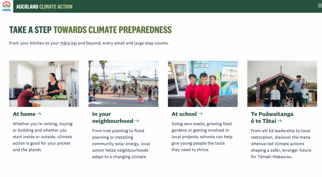
Te Huia Petition
The Future is Rail are running a petition in support of Te Huia, which you can sign here.
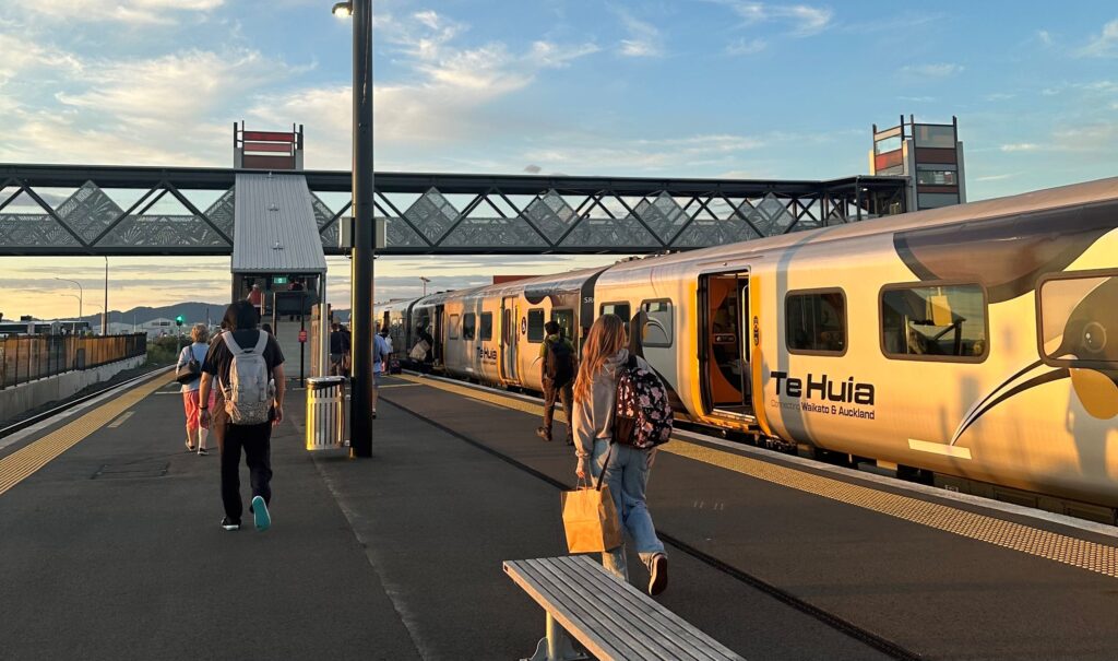
Te Huia at Rotokauri Station. Image credit Darren Davis
2026 is an exciting year for project completion in Auckland
Sam Smith in Stuff takes a look at some of the awesome projects set to open this year, such as CRL, the central interceptor, and Te Hā Noa – Victoria St linear park:
In some cases, these projects are being billed as game-changers for Auckland and are expected to transform the city.
So, what are six of the big projects that will finally see light at the end of the tunnel in 2026?
There’s a few more we can add onto that list – for starters, Project K, the Great North Road upgrade, and a few others. What are you most excited for?
The ways KiwiRail manage to break the network never cease to amaze
We’ve had some doozies over the years for how our rail network has failed, and on Monday there was another to add to the list:
Auckland rail operators have launched an investigation into how an electric passenger train entered a non-electrified section of line, damaging overhead cables and throwing services into chaos for much of Monday.
The incident occurred on a city-bound train at around 10.30am near Middlemore station, causing major disruptions on the Southern and Eastern rail lines.
A KiwiRail spokesperson said the “signalling-related issue” was involved.
The Manukau to Waitematā (Britomart) service was “incorrectly routed into a non-electrified area,” according to Auckland Transport.
The incident severely damaged the overhead line and train pantograph. Twenty-four passengers were stranded on board for around two hours before being evacuated.
This is up there with one of the highest on the list – you may recall that a few years ago, a KiwiRail contractor decided to run a software update on the signaling system right in the middle of the morning peak, shutting down the entire Auckland network.
Flooding danger
One danger not highlighted in the recent floods, is how quickly flood water can flow, even when shallow.
Most public flood maps focus almost entirely on how deep water gets, not how quickly it flows. However, new research out of the University of Canterbury using central Wellington as a case study shows that when water speed is included in models, areas classified as high risk for pedestrians increase by more than 80% and medium-risk areas more than triple – meaning many streets that look safe in shallow floods are actually dangerous.
Why are we still pushing RoNS again?
More info on the proposed Petone to Grenada highway has been released, of course once again with a lot of important stuff redacted.
It seems the preferred route goes right through important ecological areas, as reported by Justin Wong for Stuff:
The investment case suggested NZTA’s preferred route would affect about 85 houses, of which about 40 were located above the two tunnels. That was fewer than the 450 affected properties in the 2015 design but more than the 35 properties in the two alternatives that span Lincolnshire Farms.
From the short-list, the selected route had the “greatest ecological impacts on indigenous vegetation” and “moderate direct impact” on the Belmont Stream, a tributary that flows into the Porirua Stream.
Such a great idea to push through major projects, while hiding so much info…
The investment case’s entire tolling assessment, funding details and large swathes of costing information were redacted, but it estimated Petone to Grenada’s cost per kilometre would be more expensive than Transmission Gully because of “project complexity, terrain and earthworks disposal”.
It offered no particulars on timelines, only saying the project planned to submit resource consent application under the Fast-track Approval Act and start property acquisition this year.
The Wellington City Council made a submission to NZTA about its plan for two new tunnels under The Terrace and Mt Victoria, criticising the “critical information gaps” on detailed layouts, intersection designs and signal phasings.
And, from the “there’s never any money – unless you’re a road” category, Marty Sharp reports for Stuff about government declining to fund a major resilience plan for the East Coast:
A plan to reduce erosion and landslides and save taxpayers and ratepayers hundreds of millions of dollars has been given the thumbs-down by the Government.
But its proponent, Gisborne District Council, hasn’t given up trying to convince the Government it’s the most logical and cheapest course of action.
…..
Alongside the costs suffered by the region (which in 2023-24 were put at $137m to the council, $482m to the Government and $450m to local primary sector businesses) the document points to the findings of a report last year that found that since 2010, New Zealand had incurred $64b in costs from natural hazards, at least $19b of which came from central government.
The research showed that 97% of the central government expenditure was on responding to and recovering from natural disasters, with only 3% spent on risk reduction and resilience.
…..
However, in mid-January Stoltz received a letter from Forestry Minister Todd McClay saying “the Government cannot commit to providing financial support for the business case at this stage”.
“As you are aware, New Zealand is in a challenging fiscal position… The Minister of Finance, Hon Nicola Willis has signalled that budget 2026 will focus on the delivery of core public services such as health, education, defence and law and order,” McClay wrote.
Spoiler Alert: it won’t be
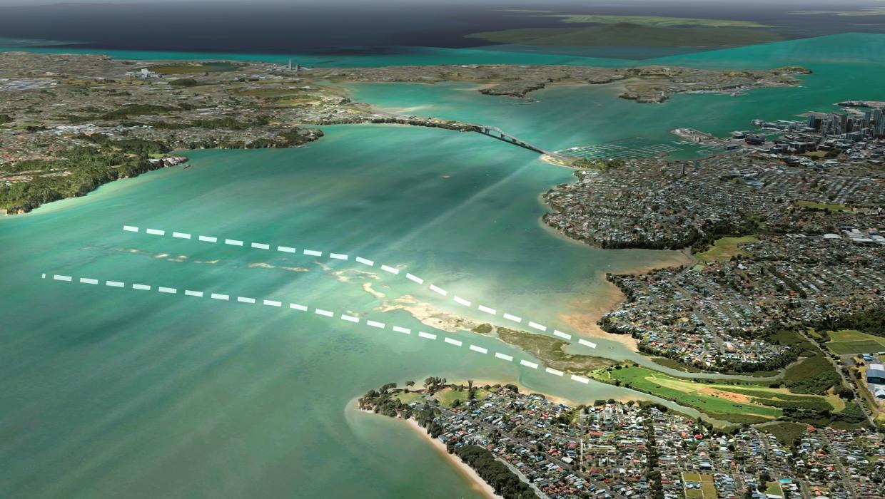
“It’s going to be on Meola Reef”, blared the Herald’s homepage on Tuesday, quoting Mayor Wayne Brown who continues to push his Meola Reef bridge idea.
Since September 2024, Brown has argued that the most viable second harbour crossing is not a bridge or tunnel to complement the existing crossing, but rather a new bridge connecting Pt Chevalier to the North Shore via the rocky reef peninsula.
The mayor told the Herald in September that Auckland Council was being kept in the dark over the feasibility study and alleged the Government was giving preference to a crossing close to the existing bridge, a claim which Transport Minister Chris Bishop rejected.
Brown’s preferred option – which the Government will be considering amongst a broader business case for the second crossing – relies on a natural existing lava flow (Meola Reef) extending 2km into the harbour to support the new structure.
Questioned whether he’d been privy to the Government’s discussions, Brown told Ryan Bridge TODAY he’s remained busy advocating for his preferred route.
“No, I’ve let them in on what I’m planning. It won’t be where they’re putting it. It’s going to be on Meola Reef,” he said.
“It goes halfway across the harbour, you put dirt on top of that and you’ve got a short bridge that goes to Little Shoal Bay.”
Putting aside the rest of the comments, Little Shoal Bay (the indent just to the left of the Harbour Bridge, below) is quite far from Meola Reef.
Road safety for Kiwis
Vision Zero is not just about humans, as 1News reports:
Every time a kiwi is killed on a road in the Russell area of Northland, a white cross is erected.
Since September last year more than ten have been put up, according to Russell Landcare trustee and technical advisor Nik Minchin.
He expects that number to climb.
“It’s just frustration, you just keep thinking of what else you can do.”
He wants people to stay vigilant on the Russell Peninsula’s roads, where he said 10-20 kiwi are hit and killed each year.
 And, for Kiwis of the human kind, this is a challenging time of year with some challenging times of day. Tragically, one primary school student has already died on our roads this week.
(Ed: Note that for almost every school, the high-risk 7-8am window will sit outside the miserly “variable speed limit” time-frame mandated by former Minister of Transport Simeon Brown, whose vibes-based rewrite of the Speed Rule permits kid-safe speeds only at strictly limited times, and on school days only.)
New Zealand’s most dangerous time to be driving has been revealed in a new report, just as parents prepare to return to their routine of school drop-offs.
Last year’s AutoSense Guardian New Zealand Insights Report found accidents related to driver fatigue were most likely to happen between 7am and 8am, right around the time children begin heading to school.
Fatigue consultant Katrina Aubrey said “the 7 to 8am window sits within a well-known low point in alertness”, increasing the risk of microsleep incidents.
“When that vulnerability overlaps with the school run – higher traffic, time pressure, children and buses – even brief lapses in attention can carry serious risk.”
Meanwhile, NZTA is consulting on speed reductions in Waikato and the Bay of Plenty, in response to local concerns about safety.
Note that one of the locations is where speeds were reverted from 80km/h back up to 100km/h, as required by Simeon Brown. Here’show NZTA summarises the commmunity’s position on that change:
The Lake Rotoiti community has raised serious concerns about the decision to reverse the speed limit for this short section of SH33 back to 100km/h.
Feedback included that the 100km/h section is sandwiched between 2 vibrant local communities with a large volume of children, visitors and tourists often crossing the state highway on foot.
The consultation follows the new process that requires a cost-benefit analysis for safer speeds, which we don’t have to remind you is the very opposite of Vision Zero and even the Safe Systems approach.
$257 million road upgrade meets induced demand in Brisbane
Turns out, spending money to make driving easier, and not providing enough alternatives, means more people drive:
It took almost 11 minutes (median) to travel the 3.3 kilometres on Moggill Road between Indooroopilly and Toowong in the PM peak in December, at a median speed of 18km/h – that’s despite a speed limit of 60km/h outside school zone hours.Moggill Road speeds are slower than they were before the COVID pandemic disrupted traffic statistics, and an extra 54 vehicles on average were travelling the stretch between Toowong and Indooroopilly each hour during the PM peak compared with six years ago.
Strategic planner Hugo Davis lives in Brisbane and commutes to Murwillumbah two days a week and said the slow points on the Pacific Highway northbound were always in the same spots – Nerang and Slacks Creek.“From that point on it’s usually a crawl into the Brisbane CBD,” he said.“The fact that I can’t easily or conveniently catch a train from home to work is a real pain and is, in my opinion, down to the shortsighted and car-dependent growth planning and politics over the past 50 or so years.“According to Google Maps, it would take me around three hours 40 minutes [an extra two hours] to get to work using public transport.“No wonder people opt for the car.”
From the socials
I love this project that pedestrianized a street in Stoke Newington. It keeps existing curb and gutter but adds amenities with a focus on natural materials. Sort of “tactical plus.”
That’s it from us, enjoy the long weekend!
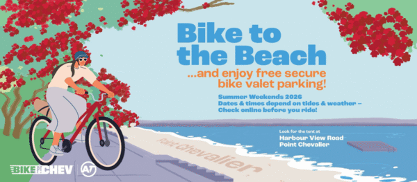
PS All weekend, from Friday to Sunday, Bike to the Beach is once again offering free valet bike parking around high tides at Point Chevalier Beach. Look for the Bike Pt Chev crew at Harbour View Reserve.
Sounds like a great way to avoid parking hassles – and en route, you can check out recent additions to the bike network! Check ahead for days and times here.

 Processing...
Te Huia was put on the wrong track arriving at Pukekohe. Had to reverse and try again.
“wrong routing” has been through the roof since they moved train control to auckland. instead of making the process foolproof they just hope for the best and blame any fool who cocks up
The Meola bridge only has two problems, where it starts and where it finishes.
And the ecological damage caused to the reef.
And the reserves on the other side.
…and is the wrong mode in the wrong place
And that it appeals to someone who really should know better.
Auckland has some serious issues trying to add more highway capacity:
a) add a bridge/tunnel that connects to SH1 at both ends across the Harbour and SH1 will just end up overloaded.
b) There is no capacity on the North Shore’s Glenfield Rd to support a northward extension of SH20 as a Meola tunnel/bridge & the SH16/SH18 route already exists.
Sydney sort-of gets away with a bridge and tunnel as there are kind-of 2 highway connections on both sides.
In Auckland, better to roll out the time of day charging and add a light rail bridge and service to the North Shore.
A short tunnel under Pt Chevaleir can fix the first problem and link in nicely with the Waterview tunnel. But the second is a real problem
So many questions.
What length of tunnel?
Would this involve paving Meola Reserve?
Have you looked at the geotechnical strength of Meola Reef?
Where would the spoil go?
How many truck movements would that be?
Where would the vents be located?
What impact would the emissions and noise from the traffic have on Western Springs College and Pasadena Intermediate students’ health and learning?
What would the impact on the water environment be?
The land environment?
Is there excess capacity within the Waterview Connection at peak? If not, whose trips would be delayed?
What’s the layout of connecting all directions?
How much land would that take?
And most importantly:
Why would Auckland ever do this, when it would:
– degrade our environment,
– create enormous unhealthy disruption,
– cost a bomb, and
– increase traffic capacity, inducing traffic, at a time when traffic volumes must be halved for environmental reasons?
Ok, a few quick answers to your answers Heidi. My proposed Pt Chevalier tunnel will be 1km long so no need for vents. Meola Reserve will be paved over. And as it will start/end a further distance from the nearest buildings of those schools than other schools are from motorways should be ok (cars are also getting cleaner and quieter with time). It will however require acquiring and demolishing all homes on Alberta Street and much of Montose Streets in Point Chevalair (roughly 100 homes). In the north things get tricky. Paving over much of the Takapuna Golf Course and a 3km tunnel (twice the length of Waterview tunnels) will be the easiest option. And this tunnel will require vents. A small mountain can be created over the rest of Takapuna golf course to deal with the soil. And the Northern busway between constellation drive and northcote road bus station will need to be moved underground to make way for the widening of the Northern motorway to handle the induced traffic
okay so absurdly expensive, destructive, and completely destroys two significant green spaces one of which is earmarked to become a highly important stormwater wetlands – yeah nah. this ain’t it.
Chuckle. So glad the induced traffic will be handled by a widened motorway. You don’t realise there’d be increased traffic at intersections and streets throughout the city, increasing noise, air pollution and danger for all…?
What you’ve suggested is hideous. The students at the school on Montrose Street need no extra traffic impacts, for starters. Rather than cars becoming less polluting over time, the impact of cars is becoming more understood. The problem of tyre particulates, noise, traffic trauma, severance, physical inactivity and road building don’t disappear with low-emissions cars.
I think I know what you’re trying to solve (“moving more cars around”)… You’ll arrive at a less absurd solution if you have a rethink of societal needs.
SH1 has 2 lanes each direction at Mt Wellington, the people going south have to suffer. Yet 5 lanes (peak) over the harbour is not enough and we need to spend many billions to fix it.
Yeah and on the North Shore end, did you know that Birkenhead village, Verrans Corner, and the entire road in between has an elevation well above that of the top of the Harbour Bridge?
And I mean the top of the arch, not the top of the road deck. It is not exactly motorway building terrain.
Wayne Brown could produce some drawings and costings of his plan. The connections at each end and the new spaghetti junctions. As an engineer he might know the costs per km of roads and other information. How many lanes. Whether it would include bikeways and busways. A guess of the number of houses to be removed. In the past NZ has paid dearly with some poor decisions. The decision by the Muldoon government not to introduce Kiwisaver was very high cost for NZ
A bridge would be a lot cheaper if he sold some of his investment properties to help pay for it
I’m not totally convinced by the ‘induced demand’ theory of road utilisations. How much of the increased traffic is due to better roads, and how much is due to the population explosion caused by Australia’s migration settings?
Like the hand-wringing around property speculation, it just seems like a fig leaf failing to obscure the biggest factor that’s increasing unaffordability.
“According to Google Maps, it would take me around three hours 40 minutes [an extra two hours] to get to work using public transport.”
Make it easier (and temporarily faster) to travel by car without addressing public transport and people are going to make the easy choice. More cars -> more congestion -> slower speeds
Speed up (end to end journeys) by public transport and more people will use it, reducing car use, fewer cars -> freer flowing traffic.
There’s plenty of evidence around induced demand in many cities around the world with low and high population growth. It’s definitely a thing.
In saying that a rapidly increasing population will also put strain on infrastructure.
Doctors Spins – induced traffic is real to the extent that a road capacity increase or new road:
a) Decreases travel time allowing people to travel further by vehicle
b) Causes mode shift so there are more vehicle trips
c) Causes time of day shift so more vehicles may move back into peak period travel
d) Increases overall trip making (increased overall trip rate and mainly new vehicle trips) within people’s overall travel time budget.
But yes, population grow plays a large part in increased vehicle travel, especially when it’s from car dependent greenfields suburbs with no congestion tolling in place.
Traffic evaporation is also a thing. Remove lanes and see less cars and often faster travel times, unaffected by population increase. Quay St is a good example.
And what NZTA studies showed for the harbour bridge, were a lane handed over to the active modes.
Since 60% of Australia’s migration is on student and temporary visas, the pressure would be on housing close to universities and employers.
This is borne out by continuing international migration (including significant numbers of Kiwis) into urban centres and increasing internal migration from cities to the regions of QLD & VIC.
Those migrants may well be moving to areas that are close to their degree mills, however it would be strange if this didn’t cause a pressure on the existing population to move further affield as their housing costs increases due to the growing demand.
Particularly as those ‘students’ and others on temporary permissions move on to more permanent visas.
Immigants! Even when it was the induced demand, I knew it was immigants!
Traffic has increased in step with population ever since the car was invented, you know, Daphne.
I’ve never met Daphne but it’s clear she’s being sarcastic.
Hugh, yes! I chuckled at her comment.
Somebody finally had the guts to stand up and say it! They come over here, after our jobs and our women, fecking Greeks!
It is called Jevons Paradox if you want to actually research it rather than just blame immigration.
My go to on this is Utopia episode on induced demand:
https://www.youtube.com/watch?v=LTCZZBrhORs&t=309s
ok racist. keep blaming “muh immigrants” for all the flaws of car addiction and suburban sprawl.
https://www.planetizen.com/definition/induced-demand
Who do you think is moving into those new sprawling suburbs?
Been down to Flatbush recently?
Quit being a pain Wayne, what about the trains? Putting him on a plane might reverse NZ’s brain drain
*bwayne dwayne
Another topic:
Consultation for The Planning Bill and the Natural Environment Bill closes at 4:30 on Friday 13 February.
I’m finding this helpful: https://eds.org.nz/wp-content/uploads/2025/08/Replacing-the-Resource-Management-Act-Risks-and-Solutions-FINAL.pdf
And also this interview: https://melanienelson.substack.com/p/rma-reforms-explained-planning-environment-councils
The EDS report I linked above was produced before the draft bills were published. It goes into detail about the issues to be resolved, and how. I’m about to watch this webinar, which was held after the bills were published:
https://eds.org.nz/our-work/eds-events/webinar-rma-replacement-laws/
YIMBYS should love the Planning Bill. Bans character and design rules that hold back densification
It’s not doing anything for me, to be honest.
It ignores or directly excludes almost every pressing matter I can think of that planning should be being used to resolve.
It’ll be really disappointing if YIMBYs submit favourably on the basis of a couple of clauses without understanding what it’ll do to Crown-Maori relations nor its complete failure to make a step improvement in modern democratic processes, which is about the only way we have of bringing our planning into the modern world.
I think it’s mostly awful
To help put the RoNS into an ecological perspective, I highly recommend the book “Crossings – How Road Ecology is Shaping Our Future”. Available on e-audiobook at the library, too.
It’s not *just* that the RoNS will induce traffic, further cement car dependency, with all the safety and accessibility impacts of that, destroy our budgets, and shatter our goals to tame carbon emissions. They’ll also further harm our wildlife and biodiversity.
Which means cancelling all the RoNS should be a political win-win-win-win-win-win-win…
but… one more lane?
/s
Wayne Brown should elaborate on how a new harbour crossing, on Meola Reef, would connect with North Shore.
As far as I can see, once you are across the channel, you are confronted by a substantial cliff.
He’s got to be having a laugh. Like when he wears his ‘rates cap’. As comedians go, he’s quite good to be fair. Luxton’s lot don’t seem to have a sense of humour. But Wayne will be gone before long, the world will move on very quickly. We may even find the next Mayor champions street running LRT, so let’s humour him for now.
“Twenty-four passengers were stranded on board for around two hours before being evacuated.”
It’s interesting that 1 News doesn’t say the train was evacuated (removing people from it) but rather that the passengers were evacuated (given an enema).
It’s bad enough they had to wait two hours, but at least they got away clean.
I can only think of one set of points near Middlemore station.
I would have thought there would be some indication to the train driver that the points were set for the freight line either on the lineside signals or on a display in the cab. Also why isn’t that section of track wired up anyway it is after all a part of the third main. It sort of means there is only 2.75 paths between Otahuhu and Puhinui for passenger trains and 3.0 for freight.
I guess the good thing about Wayne’s bridge is that it doesn’t come into the city. North shore people going south or west would use the new bridge, going city or east the old.
Of course a better option would be a rail (or bus) / walk / cycle bridge next to the current one or to Wynyard. That would have to be the cheapest option, and the one that makes Auckland a better city.
Neither would a tunnel – the proposed tunnel would link up at Spaghetti Junction meaning the existing bridge would become a local road and would allow for the removal of the Victoria Park flyover and several lanes at St Mary’s Bay and which could be repurposed into park / public space. The tunnel is the best option for a number of reasons.
“According to Google Maps, it would take me around three hours 40 minutes [an extra two hours] to get to work using public transport.
“No wonder people opt for the car.”
This video was interesting and one aspect related to the Brisbane article above: Google Maps apparently figures PT directions from historical data whereas for vehicles it doesn’t.
Anyway it’s mainly about how it doesn’t work for The Netherlands with all it’s proper bike infrastructure; instead often sends you via the main roads etc.
https://youtu.be/csHdwHTteOw?si=669xybbkvEzDZSrM
It has been using historical data from vehicles for a long time too. It usually gives you some estimate of how much congestion there will be if you tell it when you’re supposed to start driving.
The main pitfall with Google Maps is that for driving, it is only the time spent actually driving, whereas for public transport it is the true door to door time.
Morena, can anyone please tell me how much shorter the journey times will be from Manukau to Waitemata, and Pukekohe to Waitemata, following completion of CRL? I can’t find any info on this. Thx
May not be much faster unless the improve dwell times and or have less padding in the timetable. In fact with the extra southern stations opening it may go down, apart from there will be an express train option…nearly forgot that.
The main difference will be more frequency improving real average wait time or convenience of turn up and go at stations. Also with the every 2nd one going one direction or the other around the CRL/city stations it could be worse if you dont’ wait for the 2nd one. In saying that the times to central Auckland..ie Aotea/Townhall/Civic/Wellesley St type destinations and certainly K’rd will be way faster as you won’t have to walk for 10 mins or more or transfer to a another bus like the red City Link.