Auckland Transport have just launched consultation on a cycleway for a route fairly close to my heart as it’s part of my regular ride to work – Hobsonville Rd.
The corridor has seen a lot of growth in the last decade or so with all the development at Hobsonville Point and nearby Whenuapai, as well as a lot of commercial development along the northern side of the road.
This has included adding multiple new signalised intersections – something I’ve expressed frustration about in the past as AT has often included widening the road to provide turning lanes for cars at the expense of what little de facto space there was for bikes, despite the corridor having long been on plans to have safe cycling infrastructure.
In fact, adding safe bike infrastructure and improving the dangerous intersections along the route should really have been a requirement of revoking the state highway designation after the parallel motorway opened in 2011.
Back to the current proposal, here’s what AT have to say about why this route is being put forward.
Funding has been allocated from the Climate Action Targeted Rate (CATR) to deliver a cycleway along Hobsonville Road. The CATR rate provides funding for projects that reduce greenhouse gas emissions and reduce the impact of transport on climate change.
Hobsonville Road is an important connection for the cycle network, linking up cyclists to the north and to the west, including the Northwestern Path to the City Centre and beyond. It also links local users to bus stations, ferry terminals, schools, businesses and retail or entertainment.
The cycleway will provide safer access for cyclists to the Hobsonville Ferry Terminal and the Northwest bus station at Westgate which will serve local services and the Western Express. From later this year, buses will run between Westgate and the City Centre every 7-8 minutes during peak periods.
[…..]
The objective for the Hobsonville Road designation is to enable the provision of a transport corridor that:
- improves connectivity along the corridor to Whenuapai and to Westgate
- integrates with and supports planned urban growth and the future transport network in Whenuapai
- provides options for people who want to travel by bike, bus or by walking
- is safe for all users
- provides for the growth of the population in the area
The cycleway project is part of transitioning Hobsonville Road in providing dedicated facilities for those who want to cycle and make it safe for all users.
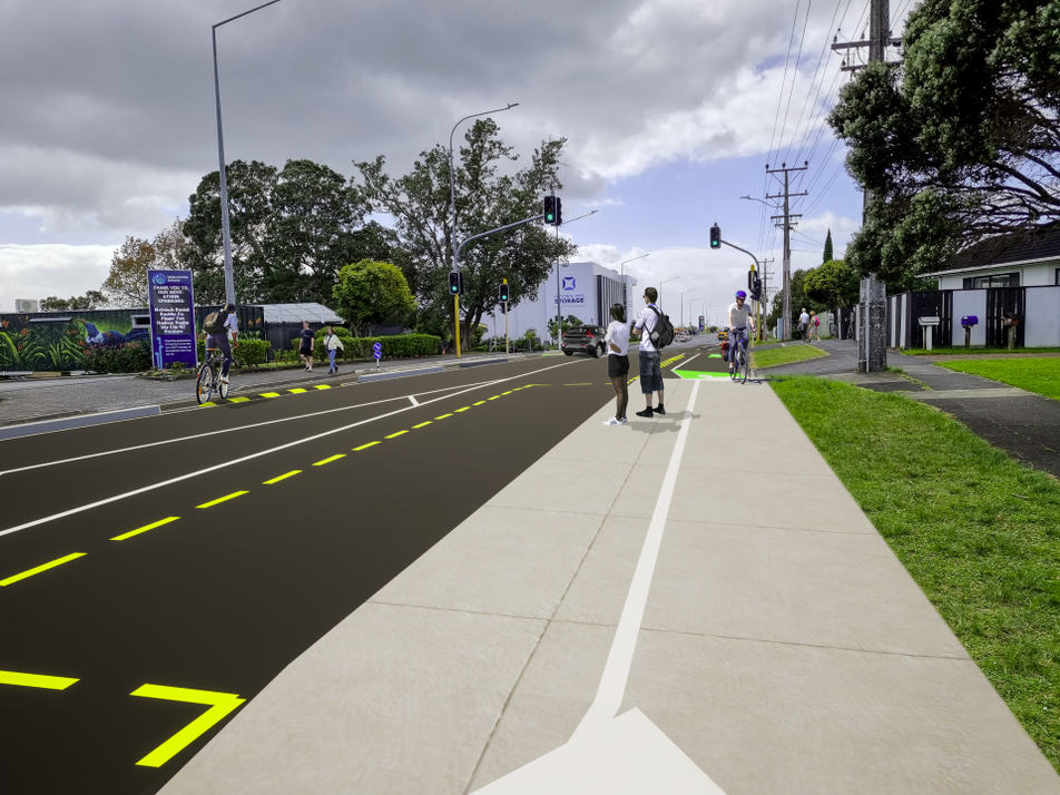
 The proposal is for a cycleway in each direction on either side of the road, rather than a two-way cycleway on just one side. AT says this is to remove safety concerns and confusion for cars exiting side roads and driveways. (So it’s a bit odd that they recently proposed replacing the existing cycleways on nearby Upper Harbour Dr with a two-way design.)
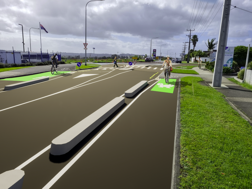
There will also be separation for the length of the Hobsonville route, but exactly what types of separators they’ll use is part of the consultation.

The cycleway will divert behind bus stops – hopefully those will have some shelter and seating? – and at intersections there will be raised tables. A few new pedestrian crossings are being added, mostly at the southern end. And, not directly related to this consultation, it must be noted that Hobsonville Rd needs a few more bus stops, as there are numerous places where the gap between stops is over 1km.

The currently proposed design should hopefully be fairly cheap and fast to construct, as most of it will be achieved through reallocating existing road space – including by removing on-street parking to prioritise movement.
Te Tupu Ngātahi – Supporting Growth alliance have a long term plan for Hobsonville Road which includes significant upgrades to the width of Hobsonville Road. This is likely to be 10 to 15 years away. The cycleway we are currently designing will be built between the existing kerb lines. We are not planning to widen the road and will not need to disrupt the current services such as power, fibre, water and stormwater in the berm space.
Hobsonville Road is an arterial road. Most arterial roads have little or no on-street parking in order to keep the route working efficiently for the movement of people. Arterial roads are also important connections for bus routes, emergency services, cyclists, other vehicles and pedestrians. The proposal currently suggests the safest and most efficient option is to repurpose most of the on-street parking on Hobsonville Road.
That nod towards the future is worth noting – it’s hard to see how AT will be able to justify “significant upgrades to the width”, i.e. significantly widening the road to move more vehicles in the middle of a climate emergency. Check back in 2033, I guess.
On parking, there are typically not a huge number of cars parked on Hobsonville Rd most of the time, but there are a few locations that likely have high usage on certain days/times, like outside Hobsonville School and the Westgate Baptist church. As with most cycleway proposals, the replacement of on-street parking to improve safety will almost certainly be where most of the opposition will likely come from.
The other main point of opposition is likely to be that for most of the route the flush median will be removed.
Overall the design mostly looks pretty good and well worth supporting, with a few aspects worth commenting on in detail. (The legend below applies for most of the images that follow).

Oriel Ave Intersection
The cycleway seems focused on accessing Westgate – however, the connection with Oriel Ave leaves a lot to be desired. Oriel Ave connects to the bright yellow bridge that spans SH16, which leads to the NW Cycleway that runs all the way to the city, so this is an important connection. At the very least it seems odd that there’s no way to get from Oriel Ave to the east/northbound cycleway.

 Flow through intersections
One of the benefits of the proposal is it will make Hobsonville Rd much safer for a wide variety of users. At major intersections, it appears the design effectively pulls cyclists off the road to use upgraded pedestrian crossings. However, more confident users are likely to want to be able to flow through intersections. Some intersections seem to allow for this, but others don’t.
For example the intersection of Westpark Dr / Westpoint Dr allows cyclists to flow through if they choose:

But the roundabout at Suncrest Dr and the Sinton Rd intersection appears to prevent this. Upgrading each of the legs of the Suncrest Dr roundabout to pedestrian crossings is good though.


There’s also an impression of the Suncrest roundabout:
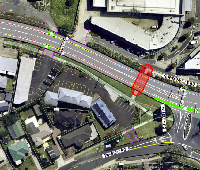
Missing Pedestrian Crossing
Possibly this is a mistake, but the design seems to have removed an existing pedestrian refuge just west of Wisely Rd. This should remain and be upgraded to a pedestrian crossing.
Hobsonville Secondary School
It feels like something better could be done with the treatment outside of Hobsonville Secondary School. For example, a few minor changes to kerbs could allow the cycleway to shift to run inside of the carparking and bus stop.

While there are a few minor improvements that could be made to the design, overall there’s a lot to like about what’s been proposed.
The consultation is open till 30 June and the form is quick and easy to fill in. There are also a few community information days planned.
Venue: Hobsonville RSA
Address: 114 Hobsonville Road, Hobsonville, Auckland
- Session 1: Monday 12 June, 5.30 to 7.30pm
- Session 2: Tuesday 13 June, 10am to 12pm
- Session 3: Sunday 18 June, 1.00 to 3.00pm
If all goes well, AT says it hopes to start construction in mid-2024 – but given how poorly AT have delivered on cycleways in recent years, I won’t be holding my breath.

 Processing...
That sentence about parking outside the school: schools and school parents are the stakeholders to win over here. They could hold community events at the school (and church) to directly present why this will be a positive project for their community.
That Wiseley, Hobsonville and Clart rd junction will be even better as raised roundabout with pedestrian crossings on all sides. Really confusing and dangerous place.
Neither this project nor the Notice of Requirement will make it any better. Can you imagine that traffic flow turning right out onto a four lane road?
https://www.aucklandcouncil.govt.nz/UnitaryPlanDocuments/09-w5-general-arrangement-plans-hobsonville-rd-part-3-of-3.pdf
Four lane road?
Lol the connection from the north west cycle way to the northern one has always been confusing. I don’t think this is going to help at all. Stupid AT. They no nothing. Except for how to build more roads for cars
Page 3 of the AT NoR drawing I linked above shows Hobsonville Rd widened to 4 lanes.
Uh, this PDF with four lane looks really scary. Is this something that’s really considered? I really hope that’s old abandoned plans.
No it is current. Formal submissions closed a few weeks ago. It will get a hearing later this year.
How did I miss that? This reminds me “ There’s no point in acting surprised about it. All the planning charts and demolition orders have been on display at your local planning department in Alpha Centauri for 50 of your Earth years, so you’ve had plenty of time to lodge any formal complaint and it’s far too late to start making a fuss about it now.”
Is cycleway thing just a decoy to start another silly road widening? That 4 lane thing looks really meaningless and wasteful.
I find it odd,that a transport agency,feels the need to consult on what type of barrier is required on a cycle lane. Of the three options offered ,there is only one that will work,but AT seem prepared to compromise safety ,if public feedback allows it. Can it be concluded from this ,that public feedback holds more sway than safety,surely the AT board members cannot allow this ,it would seem to be a dereliction of their duties.
Yes, it is odd. But even the safety head has now ditched Vision Zero, talking about “balancing” safety against “convenience for drivers”.
Yeah agree, and I don’t think I’ve seen that for road safety e.g consult on what sort of barriers you’d like, what sort of road surcade you like…they are supposed to be the experts.
They really only have themselves to blame for that.
It’s really disappointing that there’s not going to be safe connection between the NW shared path and this proposed cycleway. That 500m along Oreil Ave is what is needed here. The road is not too busy, but with cars parked on either side one has no choice but to use the whole lane – that might be fine for more confident cyclist, but for example – for children would be far too dangerous.
The fact that there’s no way to turn right into Hobsonville rd from Oreil Ave is a glaring omission. Does AT expect the cyclists to simply materialise at the beginning of the cycleway out of thin air?
+1,000.
Westgate shopping centre, while awful, is at least within biking distance of Hobsonville. Without protected cycling space through the motorway junction, it will continue to be inaccessible except by car. Many more connections needed to NW Path.
These changes should have happened at the same time that the motorway opened. It’s a disgrace that Hobsonville has been all-but-inaccessible to/from the south by bicycle for the past decade.
They need to fix the weird intersection configuration of Brigham Creek Road and Hobsonville Point Road immediately.
This is a good local cycleway, but there also needs to be a separated cycleway next to the motorway, connecting the SH16 cycleway to Greenhithe bridge cycleway.
Ah, but as soon as they spend another couple hundred million to widen the motorway, our motorways agency will add that to look multi-modal.
Yes – it’s not one or the other. Both routes are needed.
Plus…a busway.
Looks good.
So a connection to one of the busiest cycleways in Auckland, the NW cycleway, is completely neglected despite easy connection via the yellow bridge, or if they actually cared a connection by reorganising the northbound off-ramp a bit to the right to avoid so much gradient.
Typical AT, scope projects to be disconnected. Nothing changes.
Also what about the connection to Whenupai, they even show it off in their map and fail to connect it. Ridiculous, thus it still starts in a kerbed berm area that you can’t even get to.
Hell they even renewed the gap a tad north of there on that Whenupai section, AS FOOTPATH despite between immediately between two SHARED PATHS, and promising to renew it as shared path during the construction phase. They are so bloody useless its unbelievable.
SO MUCH CONCERN for people cars not getting damaged still I see, yet F&&K all consideration for PEOPLES LIVES. ZERO VISION.
Regarding works for public transport improvements, be it cycleways or bus improvements, in Wales, TFW are shutting the Treherbert Railway Line for eight months for electrication and other works. The length of the line is a similar length to Pukekohe to Papakura. So why two years in NZ and eight months in Wales to complete similar works?
https://tfw.wales/projects/metro/south-wales-metro/treherbert-line-transformation
Purely a guess – but could be combining timeframes with motorway widening project and the Drury bridge re-build?
Re: west of Wisely Rd
Surely a better place for this is closer to the other carpark entrance; having it that close to Wisely Road will bunch the right hand turners and reduce visibility for everyone – dragging it further back towards that first driveway entrance to the shops would make more sense. Plus those are all active shop-fronts and and the gym is on that side, so it’s not like you’re losing anything by having the connection slightly further back towards Hobsonville Road.
Also, how has that much development and change happened in Hobsonville in the last five years for it to only just be getting a cycleway now on the main road? And how many road safety plans and commitments and frameworks and consultations have been done at an AT level in that time-frame?
Having cycled around Hawkes Bay a lot where there are lots of bike lines (just painted ones but Hastings still has a better network than most of Auckland) I must say I despise the roundabout design that makes you go up onto the footpath then cross the roads. Instead of getting to just proceed on your route all of a sudden you now have to stop and cross, avoiding vehicles for both directions. Doing a right turn can turn into a 5 minute exercise. I leave the bike lane and bike through the roundabout with the general traffic but it’s pretty scary on some of the bigger state highway ones. Of course I am a road user like any car and biking through a roundabout is usually as fast as cars can take them, but it perpetuates the “Why isn’t the cyclist using their designated space?” argument and often vehicles pretty much just ignore you and pull out, or worse attempt to pass entering or going around the roundabout.
At least the impression here has pedestrian crossings, but presumably the bike rider is expected to dismount and cross on foot? Why is traffic flow so important for cars but not for bikes? Why don’t they apply the same maximize flow principles to bike infrastructure?
That roundabout layout is a bit… odd, with pedestrian crossings leading to grass/planted verges and cycle paths leading to solid islands… Presumably what they will actually do when someone wakes up is provide industry-standard “dual crossings” that give priority to both peds and bikes crossing the approach roads
I think this will force more people onto the motorway especially those who are not confident on the motorway causing more accidents on the short stretch between Hobsonville and Whenuapai. If you’re to do this and progress with the plan in mind, keep in mind off ramps at Whenuapai curently are already badly backlogged. Not one day I drive to work I see more then 2 cyclists. It’s a waste of money to pour into this when a small minority use cycling as a method to work when you have other options on the doorsteps of us like a ferry.
and yet if you look up the counts, a few hundred actually cycle this route everyday. Funny how so many people judge a cycleway/shared path by their anecdotal reckons of how many use it but the official counters paint a different picture.
And they always claim few cyclists on dangerous roads, and then rant about spending money on safer infrastructure.
Oh, and claim selfishness and iedological madness with a straight face…
Why don’t you just paint the cycle lane – nobody will use it anyway!
I suggest that you do not try to use the unwanted concrete dividers you were forced to remove, by public opinion, from Upper Harbour Drive or any other form of ‘eye-sore’ lane divider. They are a hazard to motorists, prevent motorists pulling off the road in event of breakdown, create difficulty for road sweepers to clean the gutters and create a problem for roadside rubbish bin collection. Looks good in the artists impression but totally impractical and an absolute waste of taxpayers money. The money should be spent on repairing and improving the road surfaces for vehicles, as they are and always will be the predominant users of roads. It would be interesting to see the survey results for the number of cyclists recorded currently using this road. Not shown in the artists impression is the proliferation of orange road cones and markers that were placed at each end of the individual dividers to make them more visible to motorists on Upper Harbour Drive. Ideological madness, at best.
The only ideological madness is that the most spatially inefficient user of our roads should hog it all for themselves.
You are practically frothing at the mouth at the thought, heaven forbid, that you might actually have to share a public space and that some safety infrastructure is required because you are all, apparently, such terrible drivers.
How many cyclists have been killed or injured by motor vehicles on Hobsonville Road in the last fifty years?
Are you saying that to be allowed to have safe cycling infrastructure, there’s a critical number of people who have to die first?
What’s the number? Does it depend on which people they are? Does it depend on whether others claim they weren’t taking enough care? I guess when they’re dead, they’re unable to present their understanding of the circumstances.
Can we count serious injuries from two-vehicle crashes, on the basis that if someone was seriously injured by another vehicle, despite the protection of having a vehicle around them, they’d certainly have died if they’d been on a bike? Or does that not count because they have to actually get on the bike and actually die, to be counted?
The answer here is this: you have asked the wrong question. The real question is: when will drivers start paying properly to keep everyone safe from the danger their driving is imposing on others? There are few risky activities in life where the person imposing the risk on others gets away without paying to keep others safe.
We all have a duty to provide a safe system for everyone. Denying that is negligent.
The road used to be safe to cycle but traffic numbers have increased significantly in the last few years. So we need to get ahead of this and make it safe before people get seriously injured and killed.
How many commuters drowned in the harbour before the Harbour Bridge was built
“How many cyclists have been killed or injured by motor vehicles on Hobsonville Road in the last fifty years?”
So the approach should be, make roads as inhospitable as possible for cyclists, thereby deterring as many users as possible, and cite no users and/or a lack of deaths to justify no safe infratsructure is needed?
Imagine if this was the justification for installing traffic signals at intersections.
“AT will consider installing traffic lights at the intersection of Fanshawe and Nelson streets when the fatality rate exceeds 1 per 100,000 vehicle movements”
Auckland transport needs to put in a raised crossing at Hobsonville Primary School, it is not on the plans. Very odd considering the majority of pedestrians on this road are very young school children.
Yes.
Unfortunately, it’s not odd at all. Pedestrian crossings “impact traffic flow”. They’ve been denied outside schools, next to bus stops, outside rest homes, shopping centres, the full works. One request was brought to the Board last month, with the ELT member in charge saying that on that road they’d already reduced the speed from 70 to 60, so… it wasn’t the most important one to do… it wouldn’t be happening in the 7 to 10 year programme … meh. Not a happening thing.
Terribly sorry to the Mrs Samson who requested that one. You’ll need to find another city, where pedestrians are valued and the official direction from the Council is followed.
Good Luck.
AT is currently structuring out key experts in active modes on the basis of a capital budget cut about 1/16 of the savings they could have made if they’d listened to reason on just one project: the Eastern Busway.
“Pedestrian crossings impact traffic flow”. And yet AT have been building raised pedestrian crossings all over Manurewa on main arterial roads (there’s now two on Great South Road within 500m of each other for example). So if AT can do it in South Auckland there’s no reason why they can’t do it elsewhere too. Or do South Aucklanders not complain like the rest of Auckland?
Mcannelly Street accessing the dairy and laundromat, 262 Great South Road accessing the bus stop, 305 Great South Road accessing Te Mahia railway station.
These crossings need protection exactly because the road is so wide and fast down this end.
Buggered if I’d want to schlep my nana-trolley across that road with just paint and signage for protection.
If you’re in a hurry, the motorway is just to the east.
Yes and a raised crossing at West Harbour School on Oriel Ave. The school opened their Bikes in Schools track this morning – so also putting in a connection from Hobsonville Rd to the yellow bridge on Oriel would begin to create a community with safe riding options.
The comments about not many cars parking along Hobsonville Road is completely incorrect. There are many areas where there are lots of parked cars. Putting cycle lanes on both sides of the road without widening it, and using some form of barrier or fixture to isolate them from motor vehicle traffic will simply replicate the poorly thought out disaster that was created on Upper Harbour Highway. Households will place their recycling bins in the cycle ways so collection trucks can actually reach the bins with their remote arms, thereby blocking the cycleways for a couple of days each week. Road sweeping trucks won’t be able to access the cycleways to clean the debris that will get blown into them, which will likely cause more punctures to the tyres of the cyclists on road bikes being asked to ride in them. To avoid this, many will ride outside the cycle lanes on roads that have become narrower and thereby potentially more dangerous to all. Add to this the massive truck and trailer units that now use Hobsonville Road on their way to and from the Mainfreight depot behind Hobsonville Primary and things only become more risky.
If you are going to put cycle lanes in, please just use painted lines to designate them as it will be much safer until the road is widened.
The rubbish truck arms can easily reach over the cycleway. I regularly reach pass parked cars. Your comment about massive trucks only re-enforces the reason why painted lines are no good. need more of a physical barrier to keep them out. All your comments are just concern trolling. All the so called problems can easily be overcome. They are going to remove the flush median so they will be plenty of room.
It’s amazing how you are able to sound like you care about the safety of children on bikes, while simultaneously denying support to the one thing that has been proven to make them safe – separation from traffic.
Incredible level of cognitive dissonance, well done.
Lol the connection from the north west cycle way to the northern one has always been confusing. I don’t think this is going to help at all. Stupid AT. They no nothing. Except for how to build more roads for cars
Submissions now open.
https://at.govt.nz/hobsonvillecycleway?fbclid=IwAR0UPQZXFDCpaztJCoKaIpB_Qdjv_DOFuIChenH_ZA89ZywoGf2YerQGDnk
I know submissions have closed but I had always hoped they were also planning a cycle-safe route using Westpoint Drive, in the hope it would link in future to Brigham Creek Rd at one end and Hobsonville Rd at the other. Although in future perhaps this is the heavy traffic route to the factories anyway? Either way the more cycle options we can provide linking routes and passing schools the better! If it’s not cycle-safe we won’t get on our bikes