Given the amount of time we put into advocating for a greater Auckland it should be clear that we love this city. Yet at the same time it can be incredibly frustrating when we constantly see missed opportunities to easily make the city better. If Auckland had a school report card it would probably read something like “the city sometimes delivers good results doesn’t live up to its huge potential due to a frequent lack of attention to detail and motivation for quality outcomes”.
These missed opportunities come in all shapes and sizes and one has recently emerged that’s emblematic of the issues we face.
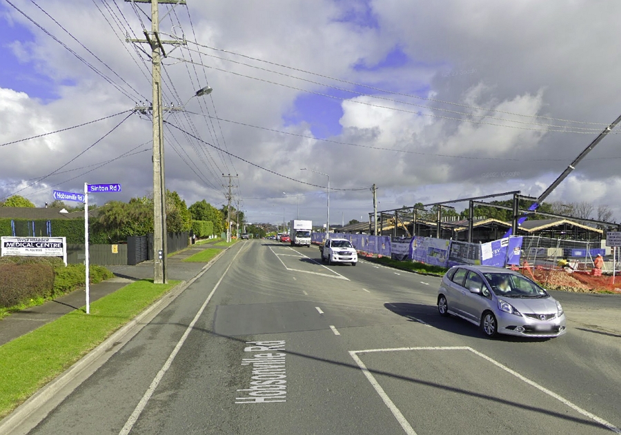
The issue is on Hobsonville Rd where a New World supermarket has been built and along with the development have been some changes to the road with a new set of traffic lights at Sinton Rd. These changes have ignored long existing plans and design guidelines and in the process made the road less safe for those on bikes. This is particularly important as this is the only currently viable route between West Auckland.
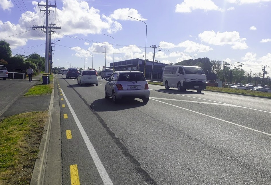
Here’s what the road looked like until recently, the same as it was when it was a state highway less than a decade ago but with the new development under construction to the right. While the spaces on each side weren’t cycle lanes, they kind of operated as such.
This location is of course just outside of the massive development happening at Hobsonville Point which is meant to be master-planned to encourage walkability and cycling. So you’d think being able to cycle to the supermarket is something we’d want to encourage. Hobsonville Rd has also long been identified on plans to have a cycleway added at some point in the future.
As mentioned, the changes to the road have included adding lights but also some localised widening beside the development to build dedicated turning lanes. These works have been completed within the last week.
Here’s what the area looks like now.
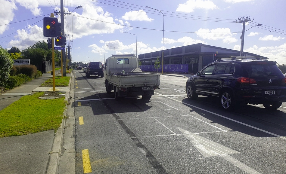
And coming from the other direction where the road has been widened taking that ‘bike’ space away to add a turning lane.
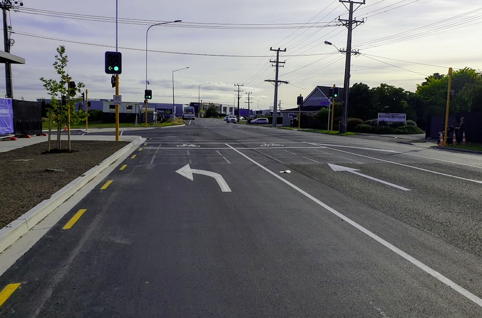
This all begs the question where are the bike lanes? While it might only be a short section, if we’re going to the extent of moving kerbs why aren’t we ensuring all modes are safely catered for. Furthermore, why doesn’t Auckland Transport claimed commitment to Vision Zero apply? What’s the point of having street design guidelines if we ignore them and why are we seeking to further entrench driving as the only viable option?
Our friends at Bike Auckland say they and the local board were basically told “sorry the supermarket has consent for this (and we don’t have money or legal requirement to improve it)“. So did the council planner who signed off on the plans not even consider this? It certainly wouldn’t be the first time the Council’s consenting team have ignored existing plans leaving us with a sub-optimal outcome. This same thing has also happened at other recently added intersections along Hobsonville Rd.
We’ve also highlighted even more egregious examples such as a few years back where we found the council signed off on not including a busway between Lincoln Rd and Westgate despite it having long been on plans and against the wishes of AT, simply because the NZTA didn’t want to do it. In both cases, having to go back and retrofit the missing pieces will add potentially substantial costs.
It also appears our transport agencies aren’t living up to the plans that were agreed when the State Highway designation was revoked.
IIRC the revocation agreement for ending state highway status on Hobsonville Road, signed by Waitakere City Council soon before amalgamation but legally binding on the Auckland Council family, includes a condition requiring construction of a cycleway on Hobsonville Rd.
— Darren Davis (@DarrenDavis10) November 23, 2020
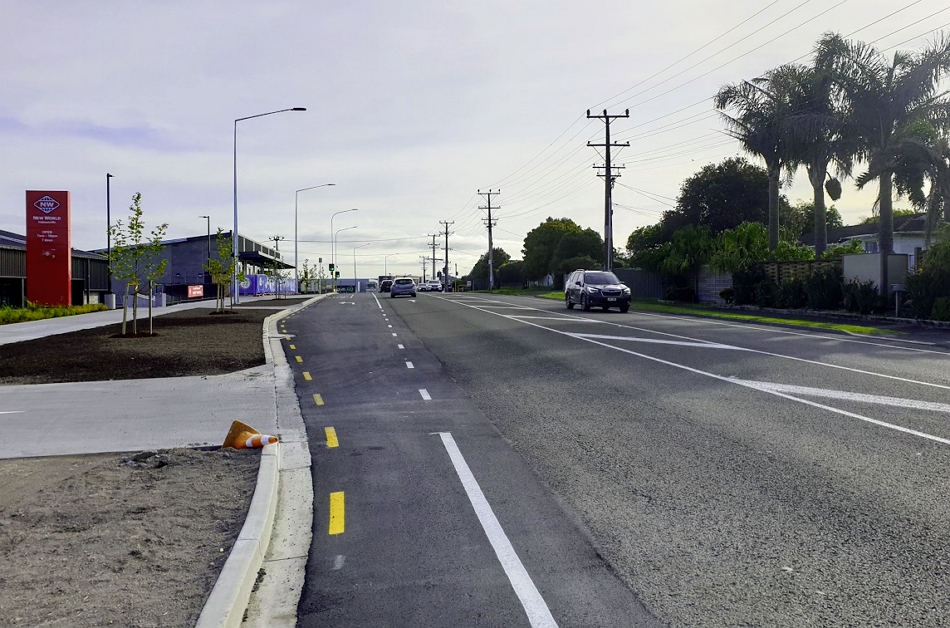
Of note that just before you get to the section highlighted above, you have to ride through this lovely hangover from when the road was a rural state highway
About the only positives here are that at least the intersection has pedestrian crossings on all sides, so we’re not adding to the number of legless crossings, and more street trees is good to see.
What really concerns me about this situation on Hobsonville Rd is that it’s a symptom of a larger issue within the council family. If it were a one off it would be one thing but we hear stories almost weekly about AC/AT staff charging ahead on projects and plans that undermine, or at least fail to take account of publicly consulted on and agreed on policies & strategies. Worryingly, it frequently seems they’ve either never heard of those policies and strategies or just don’t care and tend to carry on anyway.
What’s the point of having them if we don’t use them or no one knows about them?
Auckland has a lot to do but if we could just stop missing easy opportunities to make the city better we could make significant progress.

 Processing...
That’s my commute route to/from work and it’s been getting progessively worse with the construction going on, especially from Brigham north east through to Stinton, I ride with a mate and both are on fast road bikes, it’s a full gas drag race to get through that section, often with a howling south westerly we can sit on 45-50km and it’s ‘not too frightening’ but by far the worst part of commuting from the shore to the city.
Having those shoulders there was a godsend, now they’re gone it’ll be back to forcing your way into the traffic and praying for the best.
I’ve said it before and been shot down but I’ll say it again, all these planners should be made to ride bikes for a month or two before they rubber stamp their car friendly only designs.
I also cycle through there at times, and have had to just deal with changing roads that never seem to really get better.
Not sure if the cycle path from Hobsonville onto Upper Harbour cycleway has improved but it was very dodgy earlier in the year, doing a detour via a retirement village carpark and slippery blind corners.
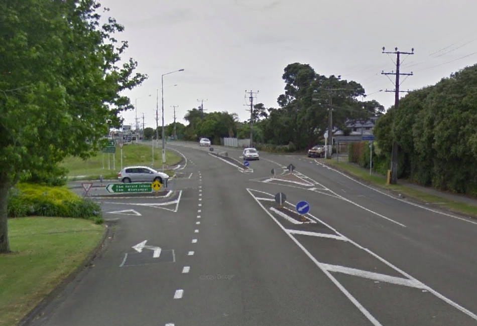
I know I have mentioned it before, and found discussion from 2016 (https://www.bikeauckland.org.nz/when-upper-harbour-drive-fills-with-cars-blame-the-bike-lane/), but my pick for one of the worst intersections on this route is the transition from coming in from the West into the North Shore and heading up to Glenfield.
They are spending hundreds of millions to smooth the flow of vehicles from Constellation/Upper Harbour onto the Northern motorway , but this intersection gives me nightmares; you come off a nice cycleway, then have to cycle uphill in traffic moving at high speed on either side while you try and move over to the left. I hate having to cycle downhill just to turn around and cycle up again, but only way I have found to get across this bit without dicing with death.
Imagine trying to cycle across this intersection – with a drop from the slip lane, and a queue of cars moving 70-80km/h + :
https://goo.gl/maps/mBeu6mywUcLPXb7z8
Defund AT.
A guy I worked with over 6 years ago complained about that same interesection because he feared for his life, he got some response saying there were plans to change it from memory.
I go through there and look down the hill hoping for gaps in the traffic that I can slot into as I arrive at the merging part, if there aren’t any gaps I ride through the lights and wait over on the concrete barrier until a gap appears and then ride up to the where I can escape over to the shoulder.
The only time it’s not a nightmare is when the traffic is so snarled up heading towards northcote etc that it’s actually stopped.
But yes, it’s def the most nervewracking intersection this side of Panmure roundabout.
I often used this route on my E scooter coming from Greenhithe along upper harbour drive on to Albany hwy.
And being dropped between cars usually doing 70 plus km/h when I can only do 32 km/h makes me feel like an idiot, but with no footpath and no way to cross the road between upper harbour dr and sunset Rd I have no choice.
I thought this section of road was going to be upgraded years ago.
I cycle along Wisely Rd to avoid it but still have to deal with the same sort of mess where it re-joins Hobsonville Rd by Countdown etc.
Thanks Matt. As you said, the local board were told it was already consented and there was nothing we could do. It was incredibly frustrating as we had already given formal feedback not supporting the plans as they stood. See item 15 of the below if you want to see. We highlighted that we didn’t support the plans as it didn’t adequately cater for active transport and we had many options for them to try to fix it. Unfortunately consent had been granted. It is a huge wasted opportunity especially being so close to cycle friendly Hobsonville Point, a key East West Route and one day the SH16 bus station will be close to the end. This intersection caused no end of frustration.
https://infocouncil.aucklandcouncil.govt.nz/Open/2020/08/UH_20200820_MIN_9750_WEB.htm
In my experience there is always something that can be done, what is missing is a will to do it. The easy way was just to say it is a done deal. The hard way was to say sorry we missed somethings lets get together and work out a solution.
A lot of the consenting stuff does get difficult I imagine. There is no way anyone will pay millions of dollars for something they are not legally obliged to.
However you would think AT would have a fund for this type of issue. Maybe it should be called the “we are going to dig it up anyway so let’s do it right” fund.
I think a lot of the issues come from Central govt not fully funding the CRL. Imagine how much money Council/AT would have for smaller projects had that occurred. Now they are penny pinching a million here and there to try and pay the $3 billion CRL cost.
They were already moving the kerbs so moving them a little bit differently would not have involved much expense. What was missing was adhering to or even knowing that there was a wider plan for the area.
The most important thing the Roads and Streets Framework provided was the forum for bringing these plans to the surface so they could be discussed together at the outset.
I established early on that this process has been given so little attention that it is ineffective.
On one project I asked how each plan was considered at that early stage, listing several plans. For those they could find, they claimed retrospectively how the project would meet the goals of the plans, but never actually admitted that they hadn’t been considered in the proper process. But for an older local plan that Council had put a lot of time and effort into, they actually asked me for a copy of it!
Had AT marked the cyclelanes first then the developer would have had to make sure there were cyclelanes included in the design. Developers have to mitigate their own effects, they don’t have to mitigate years of heel dragging by a Council owned entity. Now it will cost AT more to put them in. The blame for that rests entirely with AT.
miffy yes that thought did occur to me. Although I would have thought the council could have required the redesign to be as safe for cyclists as it was originally. Whether they were marked as cycle lanes or not they did provide some degree of safety to cyclists.
Making the road more dangerous for cycling is an adverse effect of the development. Council have failed to consider this effect when deciding conditions for development. You will note that the developer was required to add turning lanes that weren’t there before. The same can be done for cycle lanes.
Thanks, Anna.
How do you get out of the Doctors now? Did they signalise the exit?
Matt, I thought you’d know by now that anything called a strategy or plan is just a waste of time document used to make people feel better. Auckland Council / AT has an absolute ton of these documents piled up, with zero action or commitment to any of them. Councilors / board members go on some all expenses paid trip and sign some accord and write some document and that is as far as it goes.
Can you tell me a single thing they have done to try and achieve this ambitious target for example:
“What is the Te Tāruke-ā-Tāwhiri: Auckland’s Climate Plan?
A focus on clear greenhouse gas emissions reduction targets for the region, including:
– halving emissions by 2030
– reaching net zero emissions by 2050.”
It would be laughable if it wasn’t so tragic.
Basically bang on. This highlights the limitations of the RMA currently – these strategies and documents are just some of the dozens of factors that need to be considered in a resource consent process and Council only has to “have regard” to them and even they they sit at the bottom of the hierarchy of matters to be considered.
Also worth mentioning that Council’s development engineer and AT engineer would have endorsed/ signed-off on these changes and advised the Council planner as such
There is a hierachy of documents in planning. The RMA is trumps because it is legislation. National Policy Statements and standards issues under the RMA come next and then Regional and District Plans as they are all Regulation. Then comes statements created under other legislation which are all tertiary documents and finally there is all the bollocks written by Councils and their offspring organisations that count for very little even if they say ‘Policy’ or ‘Plan’ in their title. They don’t constrain or bind.
How can alterations like this occur? This is in direct contradiction to all high strategies and commitments AT are supposedly bound to give effect to. Does this encourage mode shift? Reduce emissions? Reduce traffic death and injury?
Well I guess it does increase mode shift; from active modes to driving, perhaps the idea needs further explanation to AT’s endless layers of management, who presumably sign this backwards junk off this?
Is anyone in there charged with strategic alignment, do they know what the foot soldiers are even doing, or do they just not understand their own role?
Matt, you have just emphasised why the vaunted Hobsonville Point development is a joke. They built this new ‘walkable” suburb by the harbour (I have been going there often and walking around for more than 10 years) and then they suddenly realised they needed a supermarket or two. New World built outside the Point area across a busy road as you have explained and now Countdown have secured some land even further away towards Westgate. Guess what, everybody is driving. They should have been in the middle of the “Point”. Slack planning has turned it into another driving suburb.
Supermarkets are fine where they are.
Placing the supermarkets in the middle of HP may have encouraged HP residents from driving; but the supermarkets also serve Greenhithe, Scott Point, “old” Hobsonville, West Harbour and Whenuapai.
To the AT Board. Shane Ellison wrote:
“Experts at the Auckland Forecasting Centre recently calculated the emissions savings all the planned and likely interventions could achieve. First, I asked them to list all the actions that could be delivered without recourse to new legislation or central government leadership. This includes transitioning to a low-emissions bus fleet, completing scheduled cycle, bus and rail projects… and education about cycling and walking. These interventions would reduce emissions by less than 5 per cent by 2030.”
5% is rubbish. Overseas, they’re modelling massive emissions reductions due to properly improving cycling facilities alone. And there’s LOTS that AT can do in its day to day operations, without recourse to government intervention, to achieve this. AT’s concept of the limit to the potential that cycling has to reduce emissions is imaginary.
This post is a point in case. Sure, Council has a role to play, but AT aren’t providing the best-practice expert transport advice needed, and this shows in their own projects, time after time. You could look at almost any AT project. Some that come to mind are the Royal Oak roundabout and Blockhouse Bay roundabout. To claim these are Vision Zero projects is a complete laugh. Where’s the cycling?
Sure AT will claim “no money” to do better, but that’s rubbish. They advocated for sprawl roads to be brought forward, wasting enormous amounts of money. And the Operations Centre and the Road Network Optimisation Programme are both focused on traffic flow, not modeshift or safety.
There is a deeply entrenched bias against cycling in the upper echelons of AT, and most staff are having to find ways to try to get things past certain obstructive decision-makers. If the AT Board doesn’t identify this as an issue that requires oversight, due to its enormous effects on our population and our future, then the Board itself is responsible for the cycling deaths, for the inactive, car dependent population, and for our high transport emissions.
AT is advertising for a Major Developments Interface Lead – I wonder if the person in this role will be empowered to solve issues like this? I am not optimistic.
https://www.linkedin.com/jobs/view/2282650846/?alternateChannel=search&refId=GXJEE9EcwVEC2R5j475oQQ%3D%3D&trackingId=hscxBHz21%2F6oEgmpUN1Nsw%3D%3D
I wouldn’t want to join AT now. It’s not going to be a pretty place until the problems are fixed.
It seems to me that the mayor should be stepping in to require both Council and AT processes are changed to ensure this can’t happen again.
Our mayor uses cycling projects as photo ops but doesn’t actually help the cycling programme advance.
The process is largely dictated by a combination of legislation (which Council cant change) and AT’s budgeted priorities (which aren’t really aligned with their own stated policies or AC’s). The lack of cycle provision as a result of these changes would have been because AT didn’t want to fund it – even though it would have been cheaper to do at this stage wit the developer paying for the component of road works related to their development.
There’s an easy answer – the RLTP needs to have funding for Infrastructure Funding Agreements with developers to add the missing elements. No funding means no improvements. AT isn’t allowed to just spend on good ideas without allocated funding. If democracy and accountancy didn’t matter, it would all get done, but tax and rate payers might have something to grumble about.
Don’t imagine people at AT don’t try to get these important things sorted.
And when there is funding, why is AT allowed to spend on bad ideas instead of good ideas?
For example, why did the plans for Murphy’s Rd include “Widening the road to provide two additional lanes, one in each direction.” but only “Construction of shared path along the entire length of Murphys Road.”
What sort of organisation would spend money to induce traffic, and at the same time create conflict between people walking and cycling? I’ll tell you – an organisation that when given the funding, chooses to spend it on the wrong things.
I’m not sure where the project’s at now… hopefully if it lost funding in the emergency budget it’ll be scaled back to simply reallocate road space to cycling, with any widening just about continuation of the cycle lane where there’s no road space to reallocate.
That’s what best practice requires.
And for another example, whereas best practice overseas is to deal with school traffic congestion by creating school streets, to keep the parents’ cars out and leave it safe for kids and free for the buses if there are any there, what do AT do?
In Glendowie, they’ve highlighted something they call “bus related congestion.” And their solution is… To remove the first two bus stops of the route, thus reducing bus user amenity.
Again, the funding is available – it’s just being spent on minor changes that worsen the system rather than on minor changes to restrict school traffic.
And, I know, they’ll argue with legal excuses. Because that’s what they do. We’ve had ten years of legal excuses instead of them sorting it out.
Looks like Murphy’s Rd went ahead: https://ourauckland.aucklandcouncil.govt.nz/articles/news/2020/09/improved-murphys-road-now-open-to-traffic/
Now, why do our emissions keep increasing again? Because AT keep widening roads.
“This growth needed to be supported by building or improving arterial roads, bus routes, pedestrian and cycling connections.” sounds like the good old “build a road to help the buses” argument. Did they have make the new lanes bus lanes or T3?
The whole Hobsonville Road needs redevelopment. I believe it was put on hold due to budget?
In particular between Hobsonville School and Hobsonville Point:
* The footpath on the Northern side stops abruptly at the RSA – and restarts sporadically thereafter
* The new Z station under construction appears to have the same lane layout as the New World
* Some of the intersections are unsafe – Brigham/Hobsonville, Clark/Hobsonville
And yet when you get to Te Rito Road, there are new protected cycle lanes
I know it involves more cement but if the wide berm between the footpath and the road was concreted over there would be space for cycles. This could be done at intersections with lights to control the cyclists and pedestrian. I have seen this done nicely with smooth level paths for the cyclist to transit from the road to the footpath. I am a bit old to be cycling these days but I don’t think I would like to be stopped at some intersection on a bike.
Agree, I hate intersections on my bike, especially if I want to turn right. I wonder if all traffic lights should have this concept where you get on the footpath and then there is a barnes dance phase so you can go anywhere. Or maybe a hook right turn for bikes on a green arrow similar to what they have in Melbourne (although you would have to be sure no idiot went straight through).
We often hear the council and the AT keep saying we will encourage cycling. In reality it is just talk no substance. When actually doing things, they will just keep the status of quo.
That’s why I don’t believe Phil Goff has any vision and drive. His election promise to make CCO more accountable is just bull s*it.
Our local New World is doing just fine without a dedicated left turn lane. Somehow.
What do the street design guidelines say about arterial roads, which is what Hobsonville Rd is? There may be different design standards for different classes of roads.
Franklin Rd New World car park entrance doesn’t need a slip lane https://goo.gl/maps/1nUEm9nzubEt6SU37
Mt Albert Rd has a turning slip lane into Owairaka Ave https://goo.gl/maps/kv9yrf1LSJKAW2hC9
Surely the council must have standard designs for street layouts and intersections, like the situations above, to be applied on roads with varying levels of designations/traffic volumes? These would be needed to both inform and to avoid duplication of work every time something new is built.
Hobsonville Rd clearly has marked shoulders for cyclists just like Carrington Rd, or Mt Albert Rd. So why hasn’t the supermarket entrance followed existing design examples per above. Is a slip lane actually justified?
Very disappointing outcomes.