On Saturday the government announced they were putting an extra $200 million into funding the next stage of the Eastern Busway from Pakuranga to Botany.
“Auckland’s eastern suburbs have one of the highest levels of journey to work trips by car and lowest use of public transport in Auckland. With this investment, 24,000 more Aucklanders will now live within 1 km of a rapid transit station, providing an attractive public transport service that is reliable and delivers an improved service to the city.
“The Government is investing an additional $200 million into the project, reallocated from the Northern Pathway, to support Auckland Transport in the delivery of the busway. This brings the total Crown contribution to the Eastern Busway project to over $600 million,” Michael Wood said.
Auckland Mayor Wayne Brown thanked the Minister for listening to Aucklanders and acting fast to back the completion of the Eastern Busway.
“The Northern Busway is probably Auckland’s most successful transport project of recent years,” Mayor Brown said. “We need to build on its success by finishing the Eastern and get cracking on the Northwestern busway as soon as possible. Today’s announcement is a good first step.”
The Minister and Mayor said the Eastern Busway will provide better connections and sustainable travel options with a reliable high frequency service every few minutes in peak periods, providing a 40-minute bus and train trip between Botany Town Centre and Britomart, saving 20 minutes. The new Reeves Road Flyover will improve the reliability of the busway and will reduce vehicle congestion around Pakuranga Town Centre.
By 2028, the busway will carry 14,000 passengers per day, more than four times the 3,700 bus passengers per day prior to Covid-19. By 2048 it is expected to increase to 24,000 passengers per day. The busway will increase access to jobs and education, connect people to social and community opportunities, attract investment and growth, enable urban development, and help reduce emissions.

It’s great that the government have provided additional funding for the Eastern Busway but it is bizarre that it’s taken this long for them to do it. The busway has long been listed as Auckland’s second most important transport project after the CRL and this second stage should have started as soon as stage 1 was completed last year. Yet it’s only just now getting funded and AT are still working on getting resource consent for it and there’s still no public information about their plans for the Botany station. Meanwhile, the very same day as this announcement construction started on Penlink, an $830 million road to the Whangaparaoa peninsula which even National agreed wasn’t a priority for the first decade in the original ATAP – and that was when it was only estimated cost $240 million.
I wonder how well those shelters will cope with some of the wet and windy weather we’ve had recently
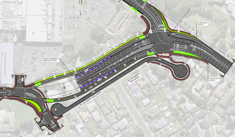
Speaking of still needing consents, Auckland Transport currently have a Notice of Requirement lodged for the parts of the project around the Pakuranga Town Centre – submissions close 19 December.
Given the design, perhaps it should instead be called Pakuranga Tarmac Centre – transit oriented development Auckland Transport style.

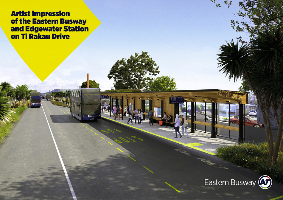
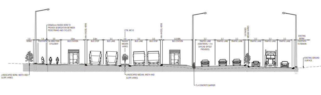
Just the Ti Rakau Rd section and the bus station combined are at least 53m wide based on this diagram.
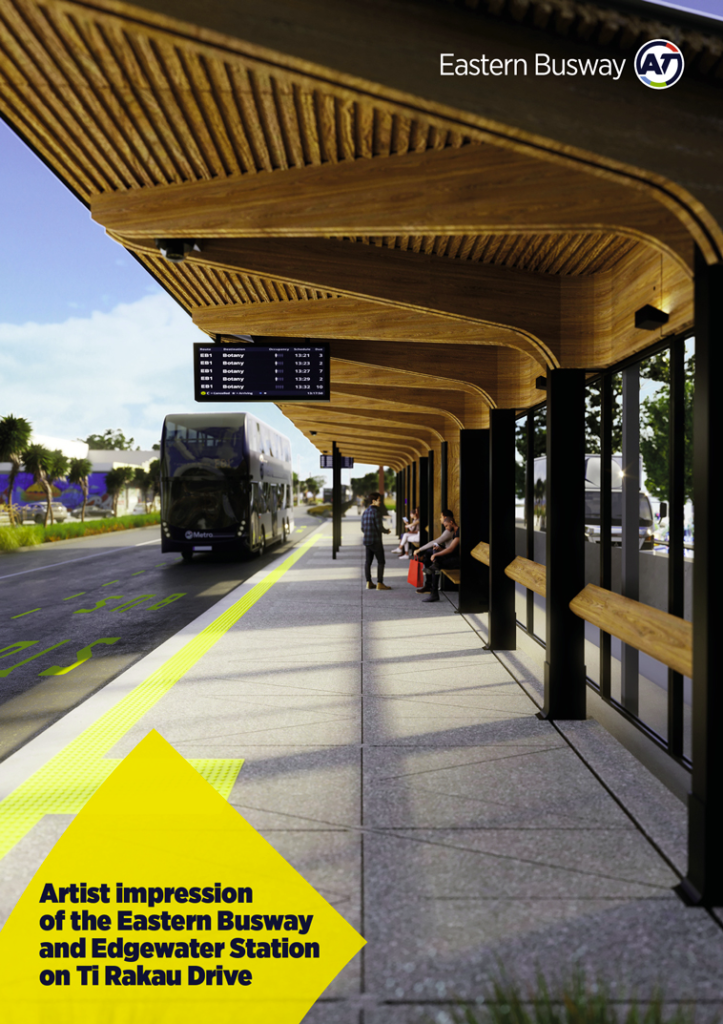
As for the station, the documents show the bus shelters are the same design as the Edgewater station above. It’s not clear if there’ll be any other amenities, such as toilets, a ticket office, bike racks etc.
To access the Panmure-bound platforms there are signalised pedestrian crossings at either end of the station but there doesn’t appear to be any pedestrian crossings to get from the bus station to the town centre and those wide-mouthed intersections on Aylesbury St look quite hostile to pedestrians.
It’s not clear what the plan is for that odd bean shaped site is between the station and Cortina Pl, an older image shows it as some sort of green space but that’s not shown in the landscaping plans in the Notice of Requirement.
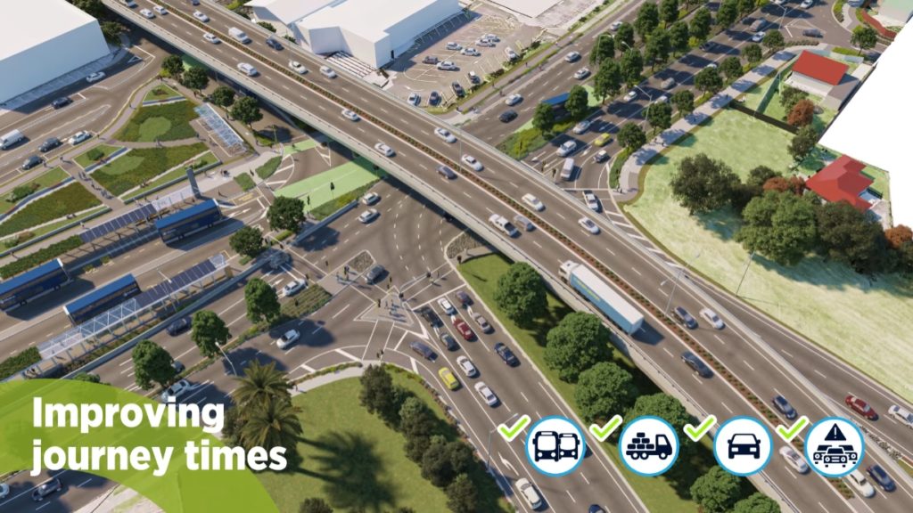
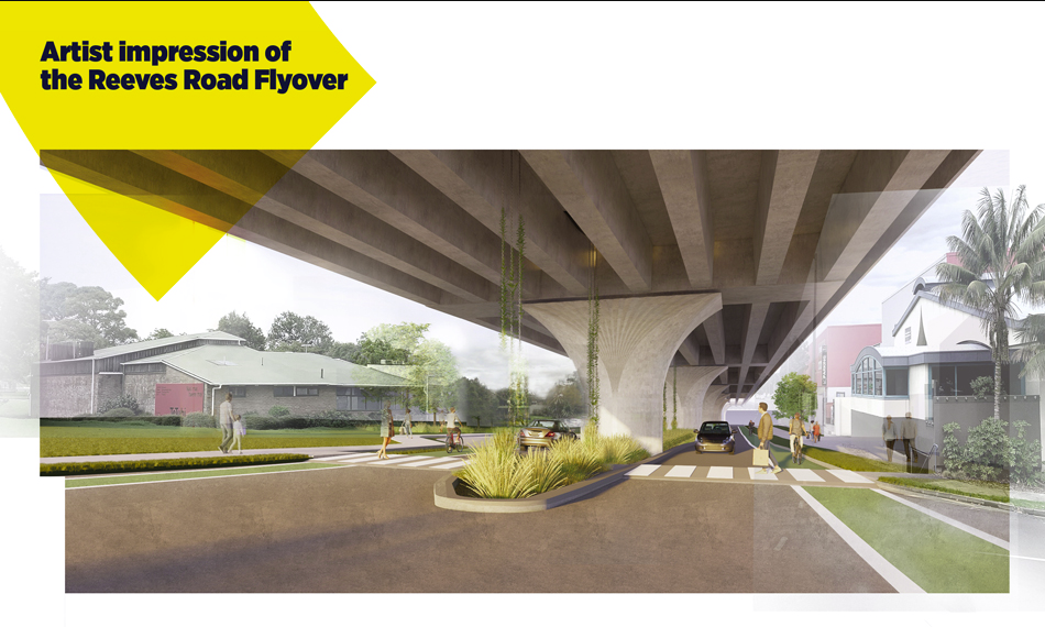
That image also shows more clearly the Reeves Rd Flyover which will dominate the area.
At the northern end where the Flyover joins to Pakuranga Rd is also quite wide.
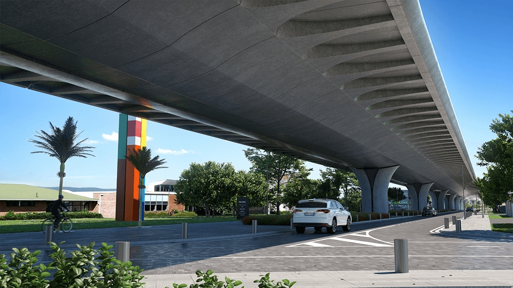
As for the flyover itself, I can recall many years ago, some project staff telling me how they were trying hard to design the flyover to be a structure that looks good and enhance the town centre. Since then we’ve had a couple of images released about it. In 2018 they showed off this design
Then in 2019 this design was included in a video about the busway. It shows the area under the flyover being used for a market.
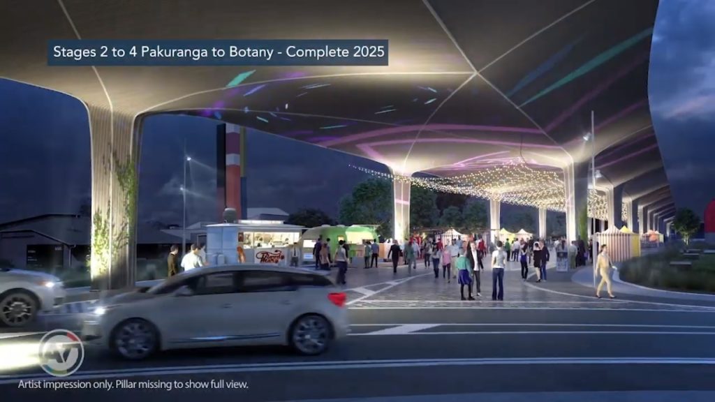
This kind of plan won’t work with the current design as the area under the flyover is needed so buses can get from Pakuranga Rd through to the bus station and Ti Rakau Dr. I’m also guessing the plan has been through a ‘value engineering’ exercise with it now looking a lot boxier and uglier (not that it was pretty to begin with).
Despite only seeking the Notice of Requirement now, Auckland Transport still suggest construction on the busway and Reeves Rd flyover could begin early next year with the project taking till 2026 to complete.
Finally, as noted in the press release, this $200 million was originally earmarked for the $750 Northern Pathway also known as Skypath or the Bike Bridge. What’s happening with the other $550 million?

 Processing...
2028?!? Come on ffs
Seriously? We’re removing houses to accommodate traffic? Where are the residents going to live – in a bus?
Stop. Giving. The. City. To. Traffic. Engineers.
They only know how to engineer more traffic.
They destroy place.
So efficiently.
I’m a traffic engineer (well I like the name “transport engineer” better but it’s just a different label). I can (and want) to do a lot of different things. But when politicians tells us not do do the right things, what are we to do? We aren’t actually the decision makers lots of the time (albeit I agree we have lots of ability to influence – both ways).
I have objected strenously to clients doing the wrong things many times. But unless they are doing something actually illegal or unethical, what is a transport engineer to do? Quit the job? Then somebody else will draw that extra traffic lane in and circle those houses for removal. The call gets made by senior managers and politicians. Put the blame where it belongs.
House removal from south side of Ti Rakau Drive is well advanced
Just got your information work started on the Reeves Road flyover before the Panmure busway was finished with a compound being established virtually across the road from Simeon Brown’s office and house clearance started
Pakuranga town centre looks just horrible with the flyover and so many lanes. This will be a terrible place to live with so much traffic and noise. Not to mention it will cost us much more than it should. I asked this question many times…if the busway is to increase the number of passengers (which should equal to the reduction of general traffic), why do we still need so many general traffic lanes? That’s just beyond me…
Pakuranga already is horrendous
That final picture of the Reeves Road flyover is almost identical to the structures erected down in Wellington on the Paraparaumu expressway – clearly got the same design team on the project regarding the concrete beams and pillars. It would be great to have room for a big covered market under there – which would certainly work better than the hope of those plants surviving in the dry central barrier area.
One question – what’s a “shyline”? On the cross section in one of the middle lanes, it notes that “an additional 1.1m shyline offset provided” – what is that?
I’d guess its a buffer distance from the concrete barrier – because cars likely are too “shy” to drive hard up against it?
It’s a traffic engineering term for how people don’t like to walk/drive/cycle close to vertical elements or similar. For example (modern) walk-cycle bridges tend to be at least half a meter wider than the path leading to/from them because riders can’t cycle as close to the railing.
What’s happening with the other $550 million?. Don’t worry about that,this will burn up that quite easily. I can see a heated debate about Burswood property values,compensating people in a falling property market ,will present plenty of issues.
CRL cost over run needs paying for
Surely that can be paid for by Wayne cancelling all the remaining AT cycling programme projects. He doesn’t need GOVT’s cancelled cycle projects!
/sarcasm
I have questions about clearances on those flyover columns with that arch style of support flanging out.
Also, just spend the extra money, give us something that looks decent and doesn’t just become a wind-swept slippery mess at the first hit of wind AND rain at the same time.
PS: Then run light rail down it and forget the stupid deviation no one actually wants.
Yeah, I’m pretty sure that no one is stupid enough to allow those arches to be so low that they get run into. As it is an exact copy of the Wellington / Paraparaumu design, it’s not an issue.
Burswood deviation is literally the stupidest thing being proposed for transport in Auckland at the moment.
I think tunnelling light rail from the city to the airport but running it above ground through Mangere so it can’t be driverless metro in the future would give it a good run for its money.
+1 Jezza.
But this is also nuts
Why is this even considered to be a PT project? The PT side of things could be done for almost nothing, all it needs is some paint and traffic light priority. All the cost is coming from trying to keep the same horrendous number of car lanes.
See also, every single cycleway project.
Exactly, the image showing the modes with green ticks is showing where the funding should be coming from …
Bribes to keep the local car-focussed politicians on-side with the PT (not actual bribes in the “buy yourself a fancy car” kind – more of the “we make sure your fancy car is not delayed by those peasant’s buses” kind of bribe).
Yes. Ti Rakau Drive is 4-5 lanes wide.Plenty to space to reallocate to public transport. But no – half a street’s worth of houses has been demolished to maintain the traffic capacity.
Given the storm water run off that occurred during weekend downpour on Athens Rd,it was raging,imagine what 53 meters of impervious surface will generate. I guess that the planners /engineers/designers take all this into consideration, but still,massive pollution implications,when dumped into the estuaries
I think their new guidelines would expect that this be put through some bio-retention swales before being discharged into anywhere. Thank the RMA for that.
Yes that bean shaped bit of land better be landscaping to help offset this tarmac monstrosity.
That 50 meter of half a lane will really make a difference /s
“I wonder how well those shelters will cope with some of the wet and windy weather we’ve had recently”
A lot better than the junk they’re plopping down out West. Seats! Why do they deserve the luxury of seats, while we’re expected to stand around like suckers?
Totally agree, the bus stops at Te Atatu interchange will not offer much shelter to the poor bodies waiting for buses that have already filled up in Westgate, Massey and Lincoln Rd.
Will there even be room for a Top up machine I wonder?
Different brief. The East Auckland ones have been designed to a “We want people to take the bus” standard, while the out-west proposals are more a “You’re bloody luck we’re even stopping at all” type arrangement where you just get ejected at the off/on-ramps and not a whole lot more.
Pakuranga town center looks horrific…book ended with the flyover and 10 traffic lanes wide. I…can’t even find words to describe. Perhaps “At best, it is a monstrosity”. Can anyone else have a go. Thanks Greater Aucklanders.
PM2.5 – that’s a lot of lung problems for anyone in that area.
53m of tarseal? no refinery suggests 53m of concrete.
10 points if you can see a single active transport user in any concept art. Its like they were briefed, no bikes…
Well, since it has no side accesses to get to it safely without fighting with four lanes of cars or riding on a narrow footpath… it’s only realistic.
How about requiring the traffic modelling be overhauled instead of spending our money on a poor design? Hopeless. We need that money elsewhere. And we need the VKT reduction that a cheaper design would have enabled. This is pathetic.
Oh but it’s too late to change anything they say.
And meanwhile on a similar project nearby at a different stage of its design – Te Irirangi Drive – where there’s definitely plenty of time to get it right, Supporting Growth have taken over the project and Supersized it too. What was designed as fitting into the existing corridor has become a monstrosity requiring the potential purchase of 475 properties.
Any leadership out there at all, or are you all too full of fear to demand up to date transport planning?
No leadership
(Except the pedal to metal double down kind).
In Toderian’s scale of urban / transport decisions, we seem to actively slipping backwards, or at least doing #3 in ever bigger projects
https://twitter.com/BrentToderian/status/754847309989457921
I was just thinking today things actually seem to be getting worse.
Its always darkest before the dawn?
The words “requiring the potential purchase of 475 properties” for Te Irirangi Drive really grabbed my attention. Are there even 475 properties on ANY road in Tamaki Makaurau, I wondered? So I had a look at the Maps feature on my computer, and I see that although the road is long, it already has two lanes of traffic on each side, and a large central berm, and 2 large side berms as well, all tastefully planted with trees. Its even got small lanes either side, like Sheddings Lane and Gransen Lane – no need to widen this traffic route at all, surely? Are WK trying to beat the record of the 1-10 (Katy Freeway) in Houston?
But 475 houses is criminal – Kainga Ora’s own data tells me that they only built 277 houses in 2021. Going to take a long time to replace those!
The remaining land may (once consolidated) have more dwellings (apartments, hopefully) than houses were demolished. But I agree, it’s one of those many downsides of trying to “have your cake and eat it too” (building bus and cycle infrastructure while not even seriously considering to constrain car capacity).
Acquiring that many properties doesn’t necessarily mean that’s 475 destroyed houses.
They typically acquire the whole property then lop off the front few metres (maybe demo a garage etc) then resell the properties at a later date. Often much simpler than trying to negotiate buying a strip of land off each property and then deal with access etc while construction is occurring.
But if they are having to demo most of those houses then that’s pretty bad for a number of reasons.
It is a positive step toward future light rail to link into heavy rail stations (Panmure in this case). Although light rail should really just be fast tracked as it has a much higher capacity and with 3 years for kiwirail to sort out electrification and fit for purpose track issues before the CRL comes online; surely all money should be poured into light rail to fill in the obvious, and flatter routes. Climate change is on a 2030 deadline and science knew it about it 70 years ago (check Mastodon if you are a nonbeliever), when motorways took over here so anything less than radical change will be insufficient. Wayne Brown has never really stood for anything beyond his own ancient ego so no surprise he is just taking the money that Efeso Collins would have more efficiently funnelled in the fight against global warming. But at least the boomer king is not denying reality as he seemed to do during the mayoral debates. We are seven decades behind and we must put aside religion and other blind ideologies to focus squarely upon the reality that sits in front of our eyes.
Crazy to think that they are only hoping for it to carry 24k passengers by 2048!! That’s basically 7 buses each direction for 16 hours a day. Hardly inspiring!! I would hope they’re plaoand aiming for double that!
As for Penlink, that’s what delaying an opposing these projects gets you.
If they’d built it a decade or so ago it would have cost less than half what it will now cost and would have had 4 lanes the whole way (allowing for T3/bus lanes) instead of this scaled down version.
We don’t really want more general traffic lanes, so scaled back is good.
Scaled back means no bus lanes not less general traffic lanes.
I see from the map you have the bus lane going in front of the Howick Bus Depot wouldn’t be more sense to go behind the Howick Bus Depot?
I see from the map you have the bus lane going in front of the Howick Bus Depot wouldn’t be more sense for the bus lane to go behind their premises?
Today’s Herald (16 Feb) has a letter by Bob Wichman stating: “The Government has given the “massive” sum of $11.5 million for disaster relief when New
Zealand is being literally destroyed by a cyclone.
Over $1 billion is being spent on a useless busway in Botany to avoid approx 1km of possible congestion and a few minutes of travel time on what is already the widest roadway in Auckland.
Bob Wichman, Botany.”
However, I don’t think he believes reallocating existing space is the answer.