This weekend saw another important milestone for public transport in Auckland with the opening yesterday of the first stage of the Eastern Busway, between Panmure and Pakuranga. The Busway is a key part of improving public transport to one of the most under-served areas of PT in Auckland.

Despite the significance of this project, there’s been surprisingly little fanfare from Auckland Transport. I can understand that uncertainty over COVID would have likely prevented them from being able to plan a big public open day. Instead, there was a press release a few days ago saying that some bus routes will be changing, and this press release came out on Saturday after the blessing and formal opening that morning.
https://twitter.com/jobartleynz/status/1471882621340639236?s=20
https://twitter.com/jobartleynz/status/1471874333110853634?s=20
COVID had another impact on the project too: it had been on track for an early completion and opening in October; however, lockdown pushed that back to yesterday.
https://twitter.com/AklTransport/status/1471586015945138182
In total, the project has added about 2.3km of urban busway to Auckland’s network with one new station on the busway itself. It has involved the construction of a new 210m bridge across the Tamaki River, as well as the removal of the once iconic Panmure roundabout that was terrible to travel through in a car and far far worse if you were on foot or on a bike. Thankfully the new project has also included the construction of a parallel shared path and cycleway.
https://twitter.com/carolgreen/status/945426279829868545?s=21
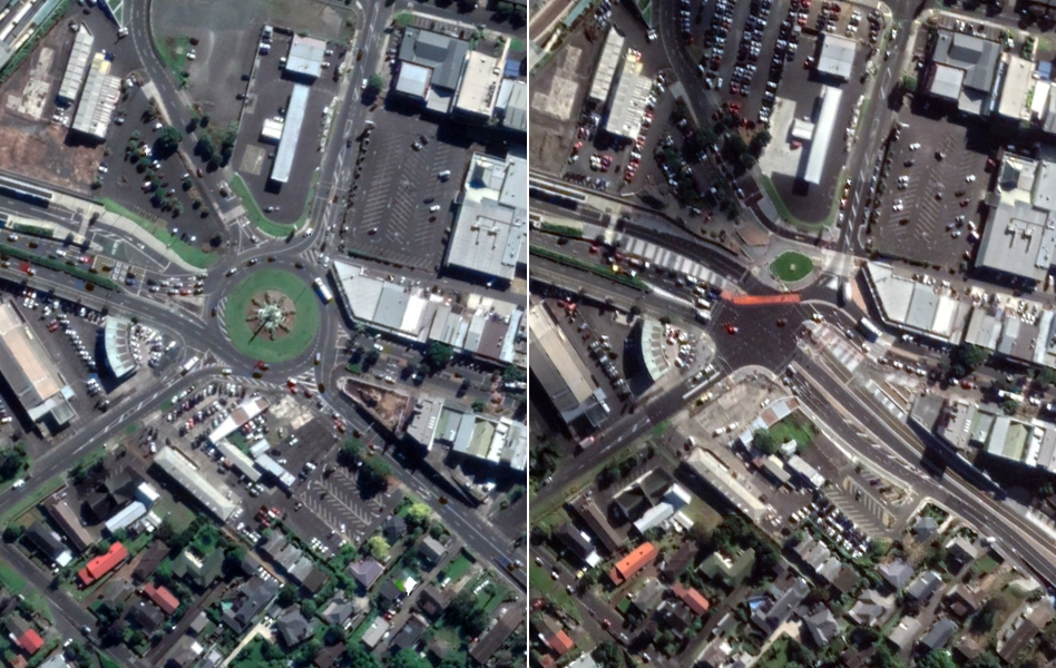
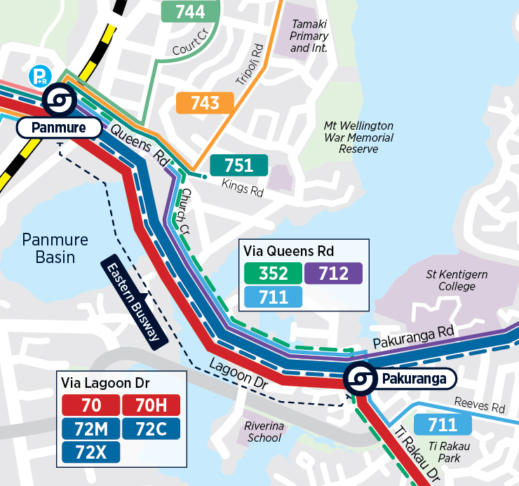
With the busway now operational, the 70 and 72 frequent services have shifted to using the new busway – although some of the less frequent routes will continue to travel via the Panmure town centre, which makes me wonder if a stop should have also been added to the busway to serve the town centre.
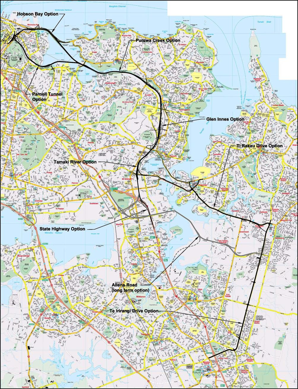
The busway has been a long time coming, having even been part of the old Eastern Motorway concept in the early-mid 2000’s. The busway as we know it today became the central pillar of the plans for improving transport in the east in 2011, following the failure of the earlier motorway plan.
Earlier motorway route plans for the Eastern Corridor. Dodged a hail of bullets here…
That it’s taken a decade since then just to get the first stage of the busway built really highlights that we need to do better with this stuff if we’re to roll out the rest of a region-wide rapid transit network.
One issue for the project has always been funding – and despite being a nationally significant project supported by both major political parties, as well as various government policy documents suggesting more central government support for rapid transit projects, Auckland has (so far) had to pick up most of the tab, with Waka Kotahi only contributing 41% of the cost.

Unfortunately I wasn’t able to get out to Panmure yesterday to check it out, but it seemed many others did, especially by bike. One thing that did concern me is the suggestion that AT haven’t put enough signal pre-emption in place
Took a ride on the first stage of Tāmaki Makaurau/ Auckland’s Eastern Busway, opened today. Impressed with the infrastructure. Less impressed with the apparent lack of signal pre-emption for buses. Rapid transit is meant to have very high levels of priority. pic.twitter.com/89UCV6pbqC
— Darren Davis (@DarrenDavis10) December 19, 2021
https://twitter.com/AlecTang_/status/1472087146613727232
busway seems nice, a few people confused the bus no longer stops in Panmure town centre pic.twitter.com/tOuCnH496P
— Jono Cooper (@consindo) December 18, 2021
Auckland Transport recently consulted on the second stage of the busway, which will see it extended around 5km to Botany, though they’re also looking at introducing a silly dog-leg at Burswood in order to not upset drivers using Ti Rakau Drive.
Once complete, AT estimate the busway will see around 30,000 trips a day, which is about the level the northern NX1 and NX2 routes carried before COVID became a thing.

It would also be good to see something done to tame Pakuranga Rd up through to Howick, to help improve bus reliability and further encourage mode shift. At the very least, it seems a couple of these seven lanes could be converted to bus lanes.
 Well done to AT on getting this first stage delivered. I really look forward to seeing the impact it has, and seeing the rest of the busway built.

 Processing...
We in New Zealand really need to standardise colours for different modes of transport. I see on one of the videos, the busways were painted green (which is the standard colour for cycle lanes) and the AT announcement video has the busways in yellow, the cycleways in blue and the footpaths in green.
No signal priority?!? Come on, surely that should be one of the Minimum requirements for this project
Perhaps the traffic light priority is not switched on yet? AT loves doing things in stages…Also, I’ve noticed that there are no new timetables yet. Does it mean that nothing actually changes even with Stage 2?
My understanding is that stage 2 will also include specific busway services from Botany to Panmure.
There is already a frequent service 70 going from Botany via Ti Rakau Drive to Panmure and further to the city.
That will continue but there will also be an additional service as I described. The 70 runs every 8 mins at peak, which won’t cut it for frequency once the full busway opens.
I wouldn’t hold out hope for the Pakuranga > Botany leg. The Pakuranga Master Blan from a couple of years seemed to indicate that they didn’t really intend on doing much at all, despite the fact you could almost run Light Rail down the middle of it.
Sorry, this should have Pakuranga > Howick*
Isn’t that one of the connected communities routes?
Originally announced in 2003. Finally. only took a few weeks to get here huh?
For an ex homeowner of a house hat was going to be removed that wasn’t.
Ah the Panmure roundabout. Back in the day, doing the suicide run going through the roundabout on a Saturday morning because I found a 50km cycle route on the Auckland City Council website, not realising that no one at the council had ever done the route on a bike (just in a ute putting up signs), otherwise why would it go up old mill road?
I read ‘underserved’ as ‘undeserved’! In a way I think the latter is probably true: I really wish they would provide amazing PT and very high density zoning to the likes of Mt Eden, Sandringham, Grey Lynn, Epsom, Onehunga, Owairaka, Mt Roskill, Royal Oak, etc and encourage a more compact European feeling city rather then spending all the money on super wide motorway like busways in the outer suburbs. LRT is a great example, previously budgeted by AT as $1 billion for Dominion Road starting construction in 2016, now its all about high speed for Mangere and Airport and coming in at minimum $9 billion and probably won’t be built until at least 2030 (if at all).
Sorry, what PT is lacking in Mt Eden, Sandringham, Grey Lynn?? The others require improvement but these are central suburbs with bus corridors that surely have busses going every 5 minutes almost all daylight hours?
Sure, one day they might have light rail corridors as well, but the current PT levels cannot be held as a reason for not intensifying, it’s just council zoning laws, surely?
Agreed, these suburbs are very well served by buses in terms of coverage and frequency, even outside of peak or on the weekends. The problem is the journey reliability (lacking or not continuous bus lanes). Yes, surface trams would probably be better but they’re (unfortunately) way into the future.
All (most) of our on street bus lanes could be upgraded fairly easily imo to something a bit more similar to full busways.
Adding bus priority right up to the intersections, with bus phases, making it illegal to block a bus lane / stop in a bus lane when turning and throw a bit of enforcement & ticketing in there, yellow cross hatching to stop people doing that etc.
Our bus lanes could be a lot better before needing to go down the mega project route.
They are only way into the future because we keep spending money elsewhere. We could have had LR on Dominion by now for less cost than the eastern busway had the project been started then, or could have had LR almost everywhere on the isthmus for the cost of the CRL. In my mind a great city has its best PT towards the centre, but the NZ / Australian / American model seems to be to spend the money on very expensive rapid solutions to sprawl because slow buses in the centre should be good enough.
Jimbo – it’s not an either or, we should have both. The reality is Auckland sprawls and has for a long time, the East has been a significant gap in terms of PT and the Eastern Busway is long overdue.
However, we should also be making improvements on the isthmus including both light rail and bus improvements on the other corridors.
We’ve managed to build multiple motorways at the same time, no reason we can’t do multiple transit routes.
Yes they have frequent buses and some green paint: but they could have had those in Pakuranga too for a fraction of the cost of the busway if they were prepared to give up some of their car lanes.
The problem is that buses in bus lanes with no traffic light priority are slow and they only seem to stop at the outskirts of the city centre so you normally have to walk or transfer which make the journey even longer. For example I just put Balmoral to Britomart into journey planner and it takes 39 minutes + up to 10 minute wait, that is hardly going to encourage you to live there is it? Add to that problems of overcrowding, bunching, diesel fumes, noise, etc which make buses a very poor alternative to rail. The European cities I am thinking of have much better options.
Its density that is lacking – you are only taking into account half of JimboJones commement. I live in Glen Eden and see heaps of town houses cropping up in hard to read, not very walkable/bikeable areas with few amenities. Density has to happen on the isthmus — Yes the villas of Herne Bay, and Grey Lynn are nice – and Remuera and Epsom have their mansions – but densifying those areas would serve to improve transport (and living) as a whole in Auckland
Its density that is lacking – you are only taking into account half of JimboJones commement. I live in Glen Eden and see heaps of town houses cropping up in hard to read, not very walkable/bikeable areas with few amenities. Density has to happen on the isthmus — Yes the villas of Herne Bay, and Grey Lynn are nice – and Remuera and Epsom have their mansions – but densifying those areas would serve to improve transport (and living) as a whole in Auckland. Those areas do not lack PT – but that PT services the most privileged of Auckland – and a high price (property and rent) has to be paid to access the PT of the isthmus.
Yes, in fact both. Adding more density to the places with good PT would improve Auckland, and so will adding PT to the places where the PT is not good, along with added density and amenities.
The initial stretch of the busway by Pakuranga has a speed limit of 30 km/h. Is it just me, or is that a massive slap in the face?
I would have thought that a bus hitting you at 30 km/h was less of a slap than 50 km/h. Why wouldn’t you want lower speeds in a station, where pedestrians are crossing frequently?
It’s not just at stations, though, where I completely agree the speed limit should be lower. But nearly the entirety of the busway from Pakuranga to the bridge has a speed limit of 30 km/h. And for most of that length of busway, there will be no pedestrians near the buses, as they are on the new footpath. Meanwhile, Pakuranga Rd itself (which has just as many pedestrian crossings) has a speed limit of 60 km/h. I do think this is too high. But the slap in the face I am referring to is letting cars travel at 60 km/h, but limiting buses to 30 km/h.
Vision zero for thee but not for me (says the car)
Gosh. Is that right? I wonder if there’s a rationale beyond “drivers wouldn’t like change…”
I really struggle to believe that. I’d believe that you road a bus on the busway when it still had the temporary 30 km/h for construction. In Alec Tang’s first video the temporaray speed limits are clearly visible.
Heidi, I haven’t been on the busway myself yet. But when I went passed on the bus earlier in the week, this is what I saw. The speed limit increases to 60 km/h not long before the bridge (the other end of which you can see in this post’s lead image). I can only imagine it is indeed because AT is convinced driver’s won’t like change, as evidenced by the fact they purchased 60 properties rather than reallocating a portion of what remains far too much space dedicated to cars.
Sailor Boy, I went passed on Thursday (on a bus, but, sadly, not on the busway itself). These were proper speed signs, not temporary signs, and a big encircled ’30’ was painted white on the road. Alex Tang’s first video starts after the transition to 60 km/h for the bridge. I’m talking about the stretch of the busway between Pakuranga and where the video starts.
Thanks for clarifying David. It seems crazy to have 30 km/h between Pakuranga and the Bridge but only for buses. I’d love to see some photos.
I do hope the rest of the busway can be 60 or 50. Doing 30 all the way to botany while cars retain their current speeds would take a lot of the competitive advantage out of the busway, especially off peak. What would be the point.
Shit an ebike would blow almost all the bus trip times out of the water. On a dedicated busway. SMH
If we are looking at 30,000 people per day it would have been good to have walkways over the top of the busway than having people walking across the busway. It would be safer and allow safer speeds. Has there been any accidents related to speed on the Northern Busway ( 50km/hr at the stations and 80 km/hour between stations)?.
I don’t think pedestrians are allowed along the Northern Busway except for the stations
Would be thoroughly odd to cross a six lane arterial street with 60-80km/h traffic at the lights but be required to use ramps over the busway for safety. If you are worried about safety then look at the road first.
Concording to the old plans archives there was meant to be a stop on the busway for the shops
Come on. The intersection at the Pakuranga end of the busway still has a missing pedestrian crossing. I thought they wanted to make the intersection ‘better’?
Maybe the intersection is ‘better’. But now from Ti Rakau Drive there is literally a three lane right turn onto Pakuranga Road when I spotted that most of the traffic is turning left.
Auckland Transport.
Yes the pedestrian crossing is missing because it is an Auckland Transport project. They have two standards, the gold plated one for everyone else and the cheap and nasty for their own projects.
The several busses that get directed to Panmure via Queen St don’t get the main benefit of the bus lanes via Lagoon Drive, its the disaster traffic in Panmure township that is a great deal of the pain getting to and from Pakuranga on the bus. It will be interesting to see if removing the majority of busses from that will have enough of an impact on congestion to make it less painful for those poor other busses that need are still going to go there. One plus of the project though it the bike lanes, its a 9 or 10 minute bike/scooter ride from Pakuranga to the Panmure station now.
Lack of excitement because the improvement is subtle. It improves the bus travel time by a few minutes but still won’t be enough to trigger a mass conversion from driving to PT.
If they are more ambitious and build light rail, the result would have much more excitement. This bus way possibly not much cheaper than building a LRT and it is a shame they didn’t bite the bullet and opt of money saving false economy.
Would have added an extra transfer for anyone travelling from east of Pakuranga to the CBD.
Auckland Transport recently consulted on the second stage of the busway, which will see it extended around 5km to Botany, though they’re also looking at introducing a silly dog-leg at Burswood in order to not upset drivers using Ti Rakau Drive.
I think this will become the metaphor for AT. (Far better politically to uproot 50 households,than disadvantage any of the motoring public). That even such a thought has made it to the discussion stage,speaks volumes. Any politician, (local or national, wanting to score cheap political points,you would think ,be all over this), but it would seem they see the best course of action ,is to remain silent .
So nobody lives at Botany so buses from futhur out will need to dogleg into the Botany stop before heading onto the busway.
How this is done will determine the success of the project. There are many traffic controlled intersection at the Botany end. They have bypassed the Panmure town centre which is good for speed however feeder buses into the Botany town centre can’t avoid the many intersections. I think we need to wait and see the final route of the busway and the siting of the Botany town centre before passing judgement. Once the busway is there the bus routes can be tweaked.
For the sanity of the non greenies, I hope they don’t convert any of the exisiting Pak Road lanes into bus lanes. That motorway and a train connection out east should have been built decades ago.
The motorway was an insane fantasy that belonged back in the 1950s, it should have and never will be built thank the lord
Dont worry, Rob. Simeon Brown actively fought the temporary T2/buslanes put in place and has demanded AT confirm they will be gone by the time the busway opens.
He is also demanding the Reeves Rd flyover be implemented.
That’s National’s new Transport spokesperson. Doubling down on traffic and SoV dependency. Absolute genius of a man.
The road has been in use for a little while now, which is probably why it opened with little fanfare. Another benefit of the project which seems to have been overlooked is that the existing Pakuranga to Panmure roads got a major makeover at the same time, and a lot of archaeological investigations were done in the area, which added to the knowledge of the area in pre-European times. And, by the way, work has already started on the Reeves Road flyover. Probably be a little while before anything stands out to the passing motorist though.
So there’s a substantial physical barrier here between buses and bikes, yet in Takapuna there’s a cycle lane running contraflow to the traffic with only a painted white line on the road. Does AT have a consistent design code?
Of course they do. Which they constantly ignore, i.e St Heliers shared path debacle
How much separation you need for contra-flow depends a lot on the traffic volume and speed you’re dealing with; national cycle contra-flow guidance shows the variety of separation options for different situations (https://www.nzta.govt.nz/walking-cycling-and-public-transport/cycling/cycling-standards-and-guidance/cycling-network-guidance/designing-a-cycle-facility/between-intersections/contra-flow-cycling/). A 30km/h street like Hurstmere with maybe 6000 vehs/day is quite different to a high-speed busway…
Separation is needed for any street with more than 2000 vpd, along with the 30 km/hr, regardless of whether it’s a contraflow lane or not.
That’s the approximate upper limit for when to apply a neighbourhood greenway shared street; above that volume you can still get away with a painted separator when the traffic speeds are no more than 30km/h (which Hurstmere definitely meets)
According to the UK’s DfT “Cycle Infrastructure Design” manual published last year:
“Where motor traffic flows are light and speeds are low, cyclists are likely to be able to cycle on-carriageway in mixed traffic, as shown in Figure 4.1. Most people, especially with younger children, will not feel comfortable on-carriageways with more than 2,500 vehicles per day and speeds of more than 20 mph. These values should be regarded as desirable upper limits for inclusive cycling within the carriageway.”
According to AT’s Transport Design Manual:
“Mixed traffic streets should be designed to operate within the
following criteria:
• Vehicle volumes – 2,000 vehicles per day, or 200 per peak
hour is the preferrred maximum, but up to 3,000 per day or
300 per hour may be acceptable.
• Vehicle speeds – less than 30km/h (85th percentile speed).
• Where local network crosses arterial roads – minimum 50
opportunities to cross per hour.
• Accessibility and safety afforded to people of all ages
and abilities.”
So, yes, I guess that fits with your vpd threshold between greenway and cycle lane.
Above that volume, a separated cycle lane with more than just a painted line is needed. AT’s TDM shows an 800mm buffer with a 150mm kerb, and above 5000 vpd, it becomes a 2m buffer with a 150mm kerb.
Debugging of the errors and mistakes are finalized for the turns. The tool of the Emergency tree services is implied for the funds. The resource is fit for the opportunities for the applied forces for the use of the offers.