Auckland Transport have announced that the Northern Busway extension will open in just over a week’s time.
We’re pleased to announce that on Sunday 8 May the Northern Busway extension between Constellation Station and Albany Station will be open for use.
The new section of the dedicated busway means buses between Constellation and Albany stations will no longer have to join the motorway. This means no time sitting at traffic lights, quicker journeys, and more consistent travel times.
Please be aware of bus stop changes at Constellation Station from 8 May:
- Northbound routes NX1, NX2 and 866 will use the new northbound stop (B) which is alongside the motorway on-ramp. Access to this stop will be via a bridge from the station building where you can use stairs or a lift.
- Routes 861, 901, 906 and 907 will always use stop (D).
For the first few days after the changes are made, we’ll have AT ambassadors at Constellation Station to make sure you know where you’re going.
This is fantastic news. I had thought the busway extension must be close to completion based on Waka Kotahi’s latest Northern Corridor video which shows many parts of the busway extension already have asphalt and even lane markings in place. It’s also notable as the motorway works on the Northern Corridor, of which the busway extension is a part of, still appear to be quite some time off completion.
The first busway services first started in late 2005, before there was a busway, when the Albany and Constellation Stations opened and buses just used shoulder lanes to get to the city. The busway itself opened in February 2008 and usage took off, reaching over 8 million trips annually before COVID struck. At peak times as many 40% of the people crossing the Harbour Bridge did so on a bus. That makes it one of the busiest and most successful PT routes in the country and that success is further amplified by the fact it delayed by decades the need to build another harbour crossing costing tens of billions of dollars.

COVID is still having an impact on PT usage but even so, this extension will only make the busway even more useful and successful because as AT note above, it will make trips to or from Albany faster and more reliable. Once open, a trip from Albany to Downtown will see about 57% of the journey take place on the fully grade separated busway with just over a further 23% taking place on bus lanes meaning about 81% of the journey will have some form of bus priority. Of the remaining 19%, almost all of it is the section of the motorway that crosses the Harbour Bridge.
Sadly what won’t be opening with the extension is the extension is the Rosedale Busway Station which is not due to open until 2025. I’m also unsure if the shared path alongside the busway will open at the same time.
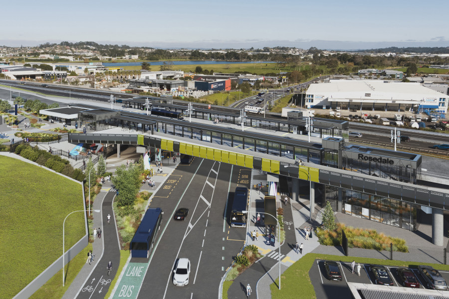
The one downside to it all is I do still think that Waka Kotahi have made a mistake with keeping the busway on the Eastern side of the motorway and having the daft loop back bridge at Albany, hampering any future conversion to light rail or a rational extension of the busway to Silverdale. A look at the latest streetview images highlights this even more as the busway has been raised considerably above the motorway and so could easily have crossed over it at Grevelle Rd and allowed for second new station in Albany South.

What Next for the Busway
Last year Auckland Transport completed a Business Case for enhancements to the Busway. It suggests that by 2038, usage of busway will rise to around 21.7 million, a 170% increase on pre-covid levels and so improvements are needed for its long-term capacity.
The business case sets our four stages (Horizons) of upgrades to maximise capacity on the busway and improve the customer experience, though the latter two stages will be dependent on what happens with potential new harbour crossings – which the government recently announced they were investigating again in conjunction with light rail.
The stages are shown below

The two stages most likely to happen are Horizon One and Two, to be clear on what they are
Horizon One – 2021-2023 – $14-$20 million
These are relatively cheap improvements that can improve things like reducing passenger crowding, circulation and bus dwell times,
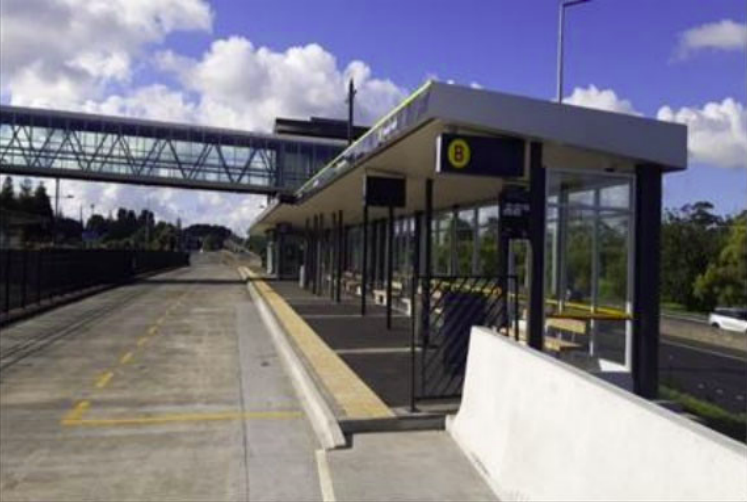
- Platform and bus stop extensions.
- Platform and bus stop widening.
- Signal optimisation on Fanshawe Street.
- Minor bus priority improvements on SH1.
- System-wide improvements, i.e. all door boarding and active queue management
We’ve already seen platforms at Smales Farm station be lengthened
Horizon Two – 2023-2027 – $80-$90 million
These are much more substantial upgrades to stations to improve capacity and pedestrian safety
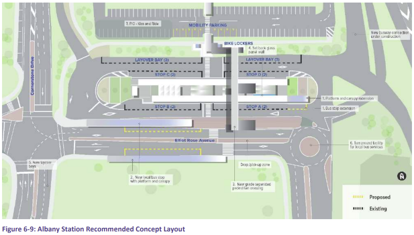
- Infrastructure to separate local bus movements from busway services.
- Grade separated crossings.
- Additional layover bays.
- System-wide improvements, i.e. off board fare collection and level boarding.
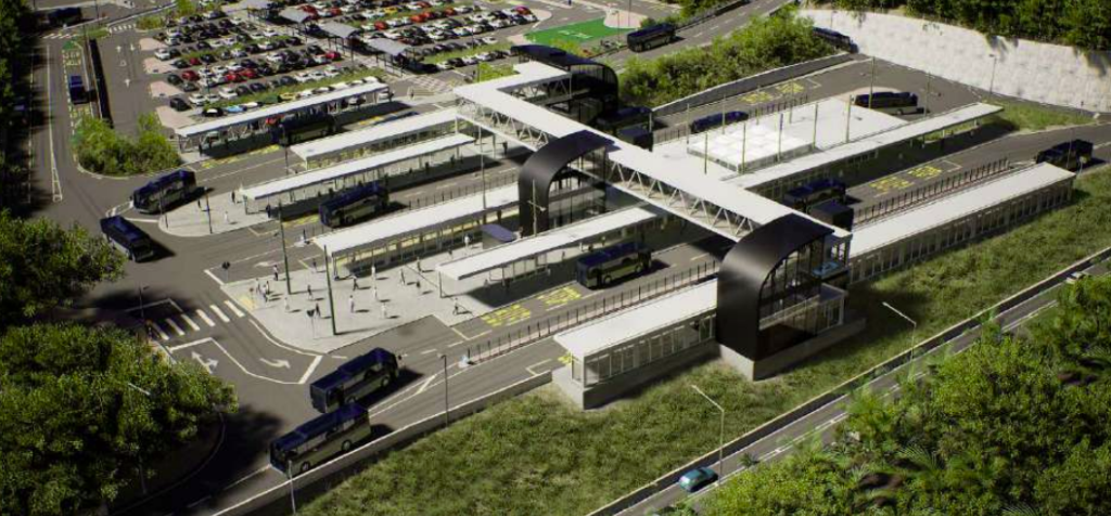
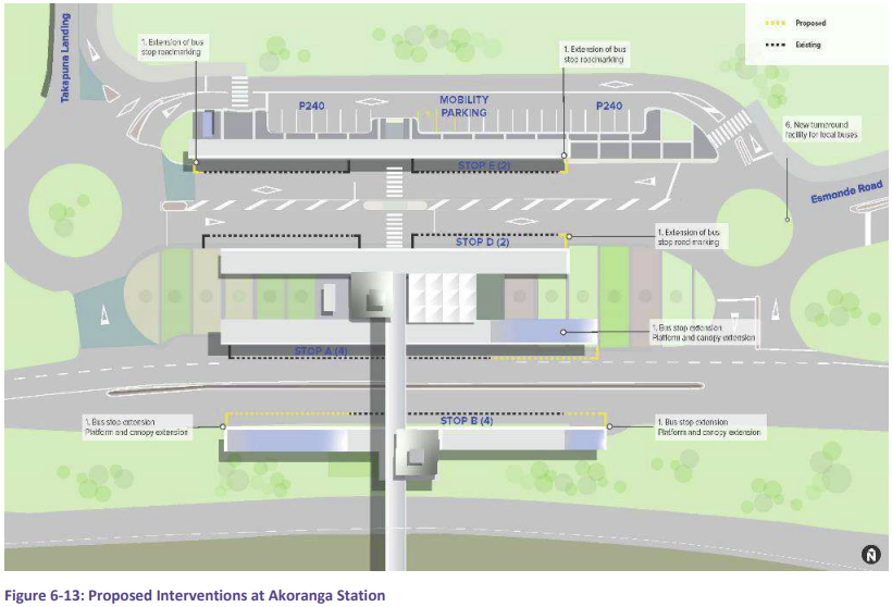
The maps below show the proposed station layouts to accommodate the changes in Horizon Two.
Albany Station
Constellation Station

Sunnynook Station

Smales Farm Station

Akoranga Station
Horizons Three & Four
As mentioned, these are dependent on what happens with a new Harbour Crossing. However, if they go ahead, they’re expected to cost $9-$12 million and $170-$230 million respectively. Stage four seems almost too cheap given it involves extending the busway to the base of the bridge, widening SH1 through St Mary’s Bay for a bus lane as well as a bi-directional busway on Fanshawe St.
Overall, these changes should help significantly improve the capacity and quality of the Northern Busway. So much so that I do wonder why the huge fascination of with another harbour crossing so soon as they could push out the need for it quite far into the future, saving us not only tens of billions of dollars but also meaning focus can be put on providing rapid transit solutions to other parts of the network, such as the Northwest, Airport to Botany and maybe even routes like Upper Harbour.

 Processing...
Is an Onewa Station still in the upgrade plans?
Wasn’t mentioned in this report at all from memory, neither was a Tristram ave stn.
I emailed one of the people who played a big part in the report but no reply.
It’s a shame because both could make the PT user experience far better. Rather than what has turned into another type of congestion for AT to attempt to manage and pour every available resource on that aspect. little to no thinking to just generally improve the transit experience, catchment and transfer options.
What is the walking and cycling access like to these stations? Are there any plans for upgrades
What a striking feature image. What are we investing here, really?
Imagine how good it would have been if it had a station somewhere people actually wanted to go.
Agree Miffy. I feel a bus services which takes people where they want to go is generally superior to one taking people where you do not want to go.
Yeah, maybe we could put them next to a University, or a large high school office park and hospital, or near a town centre, or near a big cluster of homes.
North Shore City managed to do some of that. But Constellation Drive, Albany as far from shops as they could find and now Rosedale? You need a bus to get to the bus.
And Silverdale? Is that even still Silverdale down there? Could they have found a less convenient place?
Rosedale in next to a shedload of employment. Rosedale would also make a way better transfer location for a lot of Browns Bay Albany when compared to the other stations.
I completely agree that the Albany Station was in the wrong place though. Constellation wouldn’t be so bad it it was actually zoned appropriately. Should have been 18 stories, mixed use, no car parking requirements from 2008
Silverdale is the worst of both worlds. Needs to navigate a motorway interchange on both directions in general traffic. But also is basically right beside the motorway and is separated from everything by roads and parking. Couldn’t have made it a worse location if they’d tried.
Yes and then AT opposed intensification around the Silverdale station. Apparently the computer model said there was only enough spare capacity for a bus station but nothing else. Then when they wanted park and ride the model said there was enough capacity for a bus station and a park and ride but nothing else.
I suspect the location was chosen by the Vogons at AT by drawing a 20 minute walk around the shopping centre and making sure the bus station was even further than that.
Sailor Boy the Rosedale station will be ideal next time I go to Hirepool or the Waste Management transfer station. Problem is I am usually towing a trailer and the bus doesn’t have a towbar.
I suppose that’s a great point Miffy, all of the staff just magically appear at those workplaces too, so they won’t even get to catch the bus to work.
Right so you think it is a good idea to build a station serving a low intensity area while leaving a high intensity area just to the north without any station at all. If you don’t work at AT you should apply for a job.
No worse than Silverdale I guess, but then that is a very low standard.
a) Employment in Rosedale is actually more intense than Albany South at present
b) I believe we should have built both stations. One at Rosedale and one at the back of the Mitre 10 offices
We seem to have a really perverse belief at the moment that rapid transit should have as few stops as possible to improve speed, because we ignore that walking to the station is part of the journey.
a/ The Business Park zone in the southern part of Albany allows offices as a permitted activity. The Light Industry zone around Tawa Drive has offices as Non-complying except if the office is for the industrial activity on that site.
b/ Yes I agree.
If they upgrade to light rail on this route in the future they could as per a comment in the post https://www.greaterauckland.org.nz/2020/02/13/is-the-busway-extension-on-the-right-side/ put a station on the east before the bridge over the motorway. Next to it zone for 6 story apartments or similar.
Can these park rides please be turned into apartments instead? Needing a car to use commuter PT services is the worst of all worlds.
I agree with you Matt that the backward loop looks crazy and inefficient,
I disagree with the separation of local and busway buses. The view by international experts, and applied in Brisbane and Guangzhong, is to have an open network. This means the same bus that picks people up in the suburbs continues on to the Busway and transports the people to their destination. This gives people a faster easier trips, enables busy busway stations to carry more people and uses less buses. This particularly applies to the Northern Busway with fewer stops compared to other busways, a small percentage of walk up passengers and a large percentage of people travelling to two destinations: Britomart and Auckland University. The current system was thought of in the 1970s and was continued based on a misprint in Jarett Walkers 2012 book. The correct diagram can be found on Jarett Walkers Blog Human Transit under Transferring. What I am proposing has actually been applied for people from Hibiscus Coast. They now have direct trips rather than having them all transfer at Albany.
Happy to discuss references or run numbers if people wish to
This comment is nonsense. Jarrett helped design the new network personally. Also it was a change from the previous “everywhere to everywhere” network that was developed in the 1970s.
It is not nonsense. The 1970’s reference was to how to run a a Northern Busway in the future from Anthony Cross a key member of the design team. I have a direct e-mail from Jarett Walker confirming the missprint which is easily show by comparing his book and his blog.
Jarett himself says this is an area many people find confusing.
I have found many people get confused between all point to point buses, which can be inefficient and infrequent and what I am proposing which is buses going to the bus way , using it for faster travel and coming off where they are need.
Errrr, why don’t you look up ‘branching’ on Jarrett’s site? You might understand the trade-offs better of open systems. The busway was not designed in the 1970s, nor was its running pattern. The ‘closed’ programme, ie train-like, with frequent perpendicular bus feeders is the reason the Busway is the most successful RT route in the city. Improving bus feeders to rail stations, esp Panmure, Otahuhu, and New Lynn, has been key to improving rail network too.
It is regrettable there seems much less appetite for fixing walk/bike networks to all RT stations, including the Busway. Needs addressing.
Also one of the glaring failures of the Light Rail work to date is completely ignoring the power of bus feeders, not showing any work on bus catchments, and instead designing a rambling route that tries to go direct to every possible future demand centre and imagining massive developments at each future station for its ridership.
A high frequency, highly legible, core RT service with good RoW priority, serviced by well designed feeder network is the key to adding a pan-city minimum viable RTN to AKL. Transferring is always a cost, but one with huge advantages when the system is well designed, frequency and physical ease of transfer are key. Both are present on the busway; high frequency and good safe inviting stations.
It’s tops, sorry you don’t have your own one-set ride, perhaps you should drive, if this is your key priority?
“Also one of the glaring failures of the Light Rail work to date is completely ignoring the power of bus feeders, not showing any work on bus catchments, and instead designing a rambling route that tries to go direct to every possible future demand centre and imagining massive developments at each future station for its ridership.”
Ridiculous, isn’t it. All we need is a straight line LRT down Dom Rd and then bus priority on the east-west feeders. The people designing ALR haven’t got a clue.
Struggling to see where his blog says direct services are better than connections.
https://humantransit.org/2009/04/why-transferring-is-good-for-you-and-good-for-your-city.html
Also FYI when Jarrett says something like “this is an area many people find confusing”, it his way of diplomatically saying “you are confused”.
https://humantransit.org/2009/04/why-transferring-is-good-for-you-and-good-for-your-city.html?_ga=2.160100601.591312020.1651106397-1358052596.1649633998
Here is the article you referenced on transferring.
The current pattern on the North Shore very clearly represents the “connective” option. Where the green route is the busway and the red and blue are local services running perpendicular to the busway. I’m amazed that you managed to read this article and conclude that Walker is advocating for a “direct service” network. Especially when he says “The Connective Network is faster, even though it imposes a connection, because of the much higher frequencies that it can offer for the same total budget.“
Waiukuan, it seems the busway users disagree with you. Look at the chart above. It used to have an open network with various routes running through, they were infrequent and unreliable outside of the busway, which is what happens when you have a multitude of long branches spanning busway and local streets.
Then look at what happened when they changed to the largely closed NX busway, the yellow section. Ridership skyrocketed.
All those surface carparks make me shudder.
I used the car park as after travelling two buses I could not bring my self to wait for the third to take me home. An open network reduces this so reduces the car park need
Or homes could be built that are walking distance from the PT assets….
Let’s not pretend that free car parking encourages desirable behaviour for the transport system. People that live within walking distance to the park and rides will drive because they can. This bloats the induced need for more car parking and makes walking to the park and rides more difficult.
Park and rides are car centric PT design.
Park n rides actually work. Gets people on PT, which needs more than just folk within walking distance. Get real
Subsidise driving even more. Cool idea bro.
roj taggbert. Compared to using that same land to build apartments, no not really. Park and rides embed car dependence, and the way bloat out make getting to these stations more difficult for anyone not in a car.
What makes you think the people that live within walking distance are not driving to them?
Building on system where you need a car to use a bus, is daft.
“Gets people on PT, which needs more than just folk within walking distance.”
Your statement basically claims that PT can’t work without… cars.
We should be aiming at a public transport spine running from Hamilton to Wellsford and eventually Whangarei. So any improvement and extensions are welcome. So I suppose its disappointing if this make an extension North more difficult. But I expect someone has a plan because its obvious that it will be required. I am not in favour of replacing the busway with light rail and favour a new bridge rather than a tunnel. Work on the third main and the electrification is progressing, passenger numbers on Te Huia have being good all week (school holidays). Word is getting around so expect numbers to build. Longer public transport trips replacing car trips are important. This site is called Greater Auckland and greater Auckland doesn’t stop at Albany.
To solve the Albany-north issue, just have 2 lines like WK is planning for anyway.
Current busway stays on current alignment, NEX terminating at Albany. North shore rails serves Takapuna (as planned), smales farm to Rosedale but skips Albany. New station at Albany east of the motorway (feeder bus between the two Albany stations) then up to Silverdale. Later, some of those services could divert before Silverdale to serve stations on SH1.
Being rail, no need for massive stations or park and ride.
This will make a lot of difference going north particularly from Constellation Station. I went to the Hibiscus Coast station the other day and it was quite apparent how inefficient it was joining the motorway from constellation. Had to wriggle around the place and wait through a few traffic lights waiting in queues of traffic.
Especially inefficient right now with the bus shortcuts removed due to finishing up work on the Busway. I even had an 866 last week that went via Hugh Green/Apollo/Parkway drives.
I’ve seen a few lost NX1s running via Apollo Dr myself, while out for walks in that area.
Be interesting how much the adjust the timetable of the NX buses as a result of this change. I guess it’s more the reliability that’s affected rather than straight out regular time savings.
I’ll admit to having an emotional attachment to the concept of converting the Northern Busway to a light rail or light metro line paired with CC2M.
But if an enhanced busway running bi-articulated buses or even CRRC’s claimed 5-car “trackless trams” could handle demand for a lot longer before needing a relief rail line (and a relief line that takes a different route, e.g. via Takapuna or via Northcote and Glenfield), that seems like a solid future transit outcome for the Shore.
It is a crying shame, though, that the busway wasn’t designed explicitly with an easy rail conversion in mind. Classic Kiwi “she’ll be right mate, we’ll figure it out later” attitude come to bite us back in the butt.
I don’t even think it was a ‘she’ll be right’ attitude. The busway very nearly wasn’t built because there was a genuine belief that north shore people don’t catch the loser cruiser. It was still incredibly unpopular even 5 years ago, I would frequently get told that it would be “common sense” to just change it to T2 lanes at peak.
Tbf for the tiny (in relative term) of building the Busway at the time, I think you can probably forgive it, especially as LRT conversion was probably 100 years away in their demand modelling at the time, as well as how crazy the idea would’ve seemed to the 1950s politicians we had back then
Those station re-designs looks like they are going to have entirely separate platforms for Busway routes and the feeder buses
Meaning that when it comes time (hopefully) to convert the Busway to LRT, the stations will only need minor rebuilding?
Not going to happen. Quite simply the busway has already reached the point where the disruption caused by conversion is too much to PT let alone the people pushed back to driving.
LR/LM will be built as a stand alone line/route if it gets built.
Means you get the capacity gains completely from the new line as well as the existing busway capacity.
I only hope that it doesn’t just follow the busway path. Really it should land in Northcote and go through there to Glenfield, the North Harbour industrial estate and on to Albany (adding a stop near the university and shops area). It would also have a spur from Northcote through to Takapuna.
The alternative is to head up through Bayswater, Hauraki, Takapuna, Milford then up through the Bays (roughly following East Coast Road) then again heading in to Albany. This too could have a spur in the opposite direction from Takapuna up towards z Northcote and Glenfield.
The more likely however is to zig zag roughly following the busway.
Is there really no creative way of being able to convert it inside 12/18 months?
Close one station at a time? Run the buses on the motorway shoulder while the rails are constructed?
Otherwise yes, if a tunnelled metro is to be built it should run under the west of the Shore before meeting the Busway in Albany, a spur to Takapuna is probably overkill
There are plenty of ways to manage that, not least because buses can drive on any street, road, motorway lane or shoulder. There is the motorway and about six main roads in parallel that you can use to do a temporary network while working.
Remember how they lifted the Northwestern motorway four metres in the air and doubled it’s width while keeping it open for tens of thousands of cars a day? And how they dug a tunnel through britomart while keeping it open except for a couple of weekends? You’re telling me it’s impossible to do the same for buses?
They should build rail in the busway, and run buses on road corridors in and around it. Same additional capacity without having to spend twenty or thirty billion dollars digging a tunnel.
Or to put it another way, there is simply no easier, cheaper and more effective place to build a railway line than in that busway corridor, all the stations, structures and bridges already exist, and the government already owns the whole land. Any other rail corridor will be an expensive nightmare.
Exactly, surely they could run citybound services on the motorway shoulder and outbound buses on either a temporary road or somewhere else. The stations seem like they need minimal conversion in terms of their layouts once the platforms are separated for Busway & local traffic. Just seems like a huge wasted opportunity if we don’t do that, and the crossing aside, the cost can’t be that high?
Putting light rail in the busway would cost far less than adding it to a street (no service diversions required) and far less than along a motorway (few if any new structures, stations etc required). And perhaps two orders of magnitude cheaper than a tunnel with underground stations.
There is no easier or cheaper place in the country to build rail.
That’s untrue Riccardo. There is an enormous service issue with the high voltage transmission cable feeding northland under the busway. I’m sure Transit NZ sold incredible rights away when that was added to the project. This prevents basically any lowering of the busway surface which is a killer at stations where we would now be forced into low floor trams, or rebuild every busway station, lifts etc.
A busway LRT conversion would likely involve paying transpower to replace the functionality of that cable in some other way. And anecdotally, that would be extremely expensive.
Done on the cheap, sub-optimal route, lack of priority on some sections, missing key links like an Onewa interchange.
And still “one of the busiest and most successful PT routes in the country”. Imagine if we did things properly from the get-go.
Although it has a successful busway inconspicuously running through it, that WK video simply screams “building for cars”. The oversized motorway, the viaducts, the connecting links, the vast areas of parking. . . Why are we still pouring so much into accommodating and encouraging private road vehicles? A climate emergency was declared several years ago, yet here we are still steaming on towards carmageddon.
Currently less than 1% of NZ’s vehicle-fleet is electric. Although new vehicle imports are now up to about 12% electric, we still have a mighty long way to go to de-carbonise the fleet, with import trends still heavily skewed towards high-emission SUVs. And all this before any serious discussion of where the extra power might come from if the whole fleet was electric.
We need to be discouraging driving, reducing VKT, cutting car-dependency, urgently. Yet so much of our transport-investment continues to push us the opposite way. This video epitomises the madness.
Rode the busway extension to Albany this morning (Sunday). The new platform at Constellation is impressive with lift and overbridge like Smales Farm. There is a 30km/hr zone through where the Rosedale Station will be as it looks like they are working on the platforms there, although the building is a couple of years away. The busway bridge over the motorway at Albany has 15km/hr corners at each end. The corners were really tight for the double decker I was on. Also the connections in and out of Albany Station with the bridge are a bit of a muddle with buses going different ways crossing over each others path. Will be really interesting to see what this is like in the peaks tomorrow. Overall though a very impressive addition to the busway.