Great North Rd between Grey Lynn and Karangahape Rd is one of Auckland’s most important urban corridors. It’s a corridor ideally suited to redevelopment with zoning that allows for it, and a lot has already happened, it has good public transport links with almost all buses to the city from the West and Northwest travelling along it, and it has a good grade for cycling.
Auckland Transport have launched a (lengthy) consultation for changes to Gt North Rd between Grey Lynn and Karangahape Rd as part of their connected communities programme. In general the proposal looks good, adding dedicated cycleways, improving bus lanes as well as upgrading pedestrian amenity and safety.
Here’s what AT say about the corridor.
Great North Road is a major corridor in Auckland central, carrying large amounts of traffic in and out of the City Centre. Over the next five to ten years, the area will change considerably. With more residential apartments being constructed and less industrial activity occurring, the population close to this project’s section of Great North Road expected to grow by approximately 24% by 2031.
Under the Unitary Plan, the section of Great North Road that this project is addressing, will have a mixture of land use areas. However, much of this is zoned for high-density residential housing, some of which has already been developed. Over the coming years, the population in the area, is predicted to grow significantly.
Buildings of four to six storeys are allowed within the project area. These new housing developments mean Auckland Transport has to react and improve the infrastructure which serves them. Improved access to reliable public transport and safe walking and cycling infrastructure is key, as many new developments have limited access to private vehicles.
With this increase in population comes the need for better community transport facilities. By making public transport, walking and cycling safer and more attractive, we can create better connected communities in the central city, and improve traffic flow for people and businesses.
And the key details
The proposed improvements include:
- Eight safer and more effective bus stops, removing six stops to improve bus efficiency.
- A change to bus lanes operating hours from 7-9am to 7-10am and from 4-6pm to 3-7pm.
- Three additional signalised pedestrian and cycling crossings, and upgrades to the existing three.
- Separated 1.6m wide on-road cycle paths on each side of Great North Road, with a 0.4m wide physical separator between the cycleway and the bus lane.
- Four loading bays, suitable for large car transporters, for use outside of bus lane hours.
- Approx. 115 parking spaces removed to address safety issues around visibility and to make space for the cycleways.
- Reconfiguring car parks to create 10 new P60 near the top of side streets where they intersect with Great North Road (includes Coleridge Street, Northland Street, Elgin Street, Beaconsfield Street, Grosvenor Street and Scanlan Street) off Great North Road.
- The removal of the flush median strip down the centre of the road.
A small number of trees may need be removed to make room for these changes but would be replaced where possible by up to 60 new trees. There is limited space to replace these trees due to utilities requirements, but we would work with Auckland Council on options to ensure as many of the trees could be retained.
And some of the sample images of what it will look like.
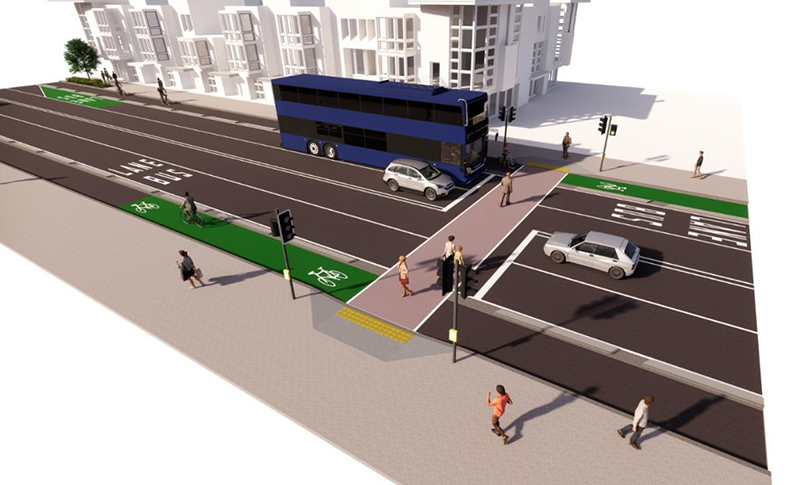
Side streets are getting raised tables, though I’m not sure why the limit line is up on the table where the pedestrians are walking.
Floating bus stops so cyclists can roll on through

Car transporters have been a huge issue on this stretch of road, often blocking bus stops and pedestrian crossings.

The biggest thing that seems to be missing here is more trees. It’s great AT will be adding 60 but would be better if they could add even more.
It’s also pleasing to see that AT have support for the project from both the local business and residents associations. That should hopefully help stop some of the typical opposition we would see to a project like this.
Chair of Grey Lynn and Around – the Grey Lynn Business Association, Paul Stephenson, says upgrading Great North Road is well overdue.
“There is huge potential to revitalise the areas between Karangahape Road and Great North Road and what happens with the road is critical for the future of local business,” Mr Stephenson says.
“Any roading upgrade has to work for communities as well as commuters. This is a once-in-a-generation chance to connect Grey Lynn to the city and build a better place for new businesses along the Great North Road ridge.
…
David Batten, of the Grey Lynn Residents Association, says this is a prime opportunity to realise the potential of Great North Road and do even more than what is proposed.
“The Great North Road precinct has the potential to become a boulevard of international significance with a thriving streetscape that is safe for both pedestrians and cyclists.
“We have just released a community led vision for Great North Road and it’s more than just the planned removal of parking, the addition of cycle lanes, bus stops and pedestrian crossings.”
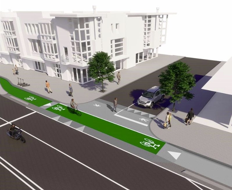
Here’s the residents association vision, which includes this image.

One thing that is somewhat weird is just how long consultation is with it being open till 7 May.
Of course you may remember this isn’t the first time that AT have consulted on a proposal with them also doing so back in 2017. It’s frustrating that they’re doing all this again 4 years later, and also frustrating that if given the go-ahead, it’s not likely to start construction till 2022/23 – it looks like my 2019 predictions were mostly accurate.
There have at least been improvements to that old proposal though. Most notably that I can see there’s:
- Better treatment of side streets, including raised tables now.
- Better treatment of bus stops with floating stops – the previous one had the bus stop platform shared with the cycleway, like at Victoria Park.
- The Bond St intersection gains pedestrian crossings on all legs, removing a legless crossing – the previous plan was still missing one.
Overall a good project and is worth supporting so jump in there and give some feedback.
More projects like this please AT.

 Processing...
You don’t create a boulevard effect by plonking trees along the middle of the road per that last render. You need only look at Symonds Street or the short section of Clark Street outside the New Lynn train station to see how that doesn’t work. Boulevards are roads flanked by trees and that’s why they work. Their primary function—historically, at least—is to provide shade for active modes, not to greenwash AT’s traffic flow at all costs agenda.
Yes. Who is going to tackle that our basic design for utilities placement doesn’t work for trees, if that is the problem?
The last render is from the Grey Lynn Residents’ association, not AT. Services is the reason given by AT as to why there are so few trees.
Classically for GLRA the render seems includes a 2 storied new build with set backs on a site you could build 5.
Greetings Conan, you are making judgements about the GLRA where there are no precedents. There is a renovated 2 story building just finished opposite Bond St – we would like to see more granulation re building heights – higher on the north side and less so on the south side where there are amenity shading issues down in lower Arch Hill in some spots
Are heights already defined in the Unitary Plan aka not really a discussion point and down to developers on what they want to build and whether there is a market for it?
Isn’t this the road the light rail labour supposedly promised once upon a time is going down? Didn’t see that mentioned or allowed for.
No, it isn’t
That actually looks really good. Great that the local associations are on board. With the increase in people walking in the area businesses only stand to gain over the longer term. Awesome that they understand this too.
“Four loading bays, suitable for large car transporters, for use outside of bus lane hours.“
Good to know if I build a supermarket or any other major business, I don’t need a loading dock, I can just use the street and unload everything there and AT will eventually cater for it. These car sales yards have to see the writing on the wall. Eventually those bus lanes will have to become all day at least. I suppose their land will be pretty valuable by that time. To be fair this is a pretty small change to keep them happy for the next few years. At is smart to cater to them.
The floating bus stops are great. Hopefully no watering down. I’d rather they canceled the projects where residents were against any real changes eg st heliers and shift money to bringing this project forward.
Yeah you’d hope the market finally prices the car yards out of the area, an absolute waste of space and criminal use of roadspace as well
We’d have to allow the market to work without skewing it, Kraut.
https://www.greaterauckland.org.nz/2019/04/30/great-north-boulevard/
Yes all you have to do is build your supermarket or other major business before the Council sticks a rule in the planning documents requiring you to have on-site loading. Oh dear it looks like you missed out.
Or you can just park illegally, dangerously and do it for years knowing you will not be subject to any enforcement.
Yes establish your activity legally and park legally for years and then have AT take away the parking and loading spaces without consultation so the only choice left is in the middle of the road. It is good that AT finally understand they have a duty to allow deliveries to occur.
When was parking removal in Auckland last undertaken without extensive consultation. About a few decades before the Beatles were new, I think.
Sorry I wasn’t counting the “Please send us your comments before we jam our bus lanes in and rip out all the kerbside parking and loading spaces” that they did on Great North Road. I was meaning actually finding out who needed that kerbside space and finding ways to allow for loading to occur. This time round they seem to have done that and actually listened. When was the last time they did that?
When did AT last put in bus lanes anywhere in Auckland?
I’d like to see when the market prices McLaren and Tesla out of K Rd.
Those dealerships are doing a public service. Providing quality art in the form of nice as cars that you get to look at. Plus the volume of sales is pretty low.
I was more referring to Mazda and Toyota etc, much higher volumes and flat open lots.
I’m sure Porsche Tesla etc can afford to have smaller transporters (and maybe already do) that would fit on side streets. Or drive the vehicle itself.
tesla car transporters are the same as any other car transporter and they do exactly the same ridiculously dangerous shit. the difference is they were consented way after auckland council knew the issues with loading, and had published a bunch of plans saying the area should be designed for pedestrian activation
Genuinely shocked by 2 aspects
1. The removal of the Compulsory Auckland Transport Median Strip™, which is apparently mandatory on every road in Auckland purely to suck space from safe cycling facilities
2. The cycle lanes seem to actually tick all the boxes, unlike the garbage recent efforts on Victoria St & K Rd
Also, maybe we can get the Residents Association to design all of AT’s streetscapes from now on?
Sorry, also
3. THEY ARE ACTUALLY REMOVING CAR PARKS, HOLY SH**T
At this rate, by 2121 we should really be getting somewhere… 🙂
Yes, to the Grey Lynn shops where plans for the centre were nixed by local shopkeepers concerned about the loss of 4 parks.
It’s a plan that actually looks like the future or Auckland – super exciting. They now just have to execute…
The other drawback is the lack of Dutch style protected intersection at Gt N Rd, K Rd, Ponsonby Rd intersection. Intersections are the most important part!
Indeed – this is a major junction and needs full cycle protection in all directions.
There are good precedents for protected junctions in AT’s ‘Urban Street and Road Design Guide’ (p. 95) https://at.govt.nz/media/1980686/urban-street-and-road-design-guide.pdf
Overall this is a very welcome scheme. More like it please.
Yeah was a wee bit shocked when I read all this. They haven’t come up some weird hybrid only NZ could design, not based on bes practise to try and please everyone and no one.
Looking forward to it and more residential and hospitality going up along there.
The most exciting thing about these plans is the Lancia Delta Integrale waiting at the stop lights in one of the renders.
Is there any plans for future-proofing Light Rail up the middle? Hopefully any digging up of the corridor itself will see services moved now so it can be done easily in the future.
Lets be honest, there will have to be about 6 lines of LRT in Auckland in existence before any is built on this road sadly
I guess you’re right. I’m just kind of disappointed that we’re still going to have a massive wide expanse of tarmac to replace the existent massively-wide expanse of tarmac we have now.
What is the planned alignment for the NW line? I would have thought having it run along Great North Road until Pt Chev would be the best route
Fingers crossed that will at least break ground this decade
And another line that runs Mt Albert rd (past the train), Carrington Rd, then down Pt Chev rd.
I made this point too that light rail was promised down this road. Comment appears to have been moderated out. Doesn’t seem to be in the planning anymore.
Someone in the visualisation business clearly has a thing for 1980s Italian rally cars. There were two Lancia Delta Integrales in London’s East-West Cycle Superhighway visualisation at Blackfriars Bridge. https://consultations.tfl.gov.uk/cycling/bbb5ba68/user_uploads/blackfriars-junction.jpg
Couldn’t figure out what looked off about this, until I realised it was RHD. I can see the appeal for planners though; compact, practical, functional…
Good spotting the rare lancia. Lol. Must be an Italian car enthusiast working there who inserted it.
I cycle this route every day. It works fine how it is right now. It could be improved, but the budget isn’t unlimited and other areas need investment more.
Works fine for who? You, and some others who are currently using it?
What about the people who aren’t using it, or who used it and gave up, because it isn’t fine for them… That’s who these projects are for.
Command line interfaces were great for the small number of computer users in the 1970s but were hardly a mainstream product. Same goes for “sharing” a busy road on a bicycle with general traffic.
Not for me either. I live on the road. Try not to cycle it.
And especially K Rd at the moment. Not sure about this one either, think it could turn into another Franklin Rd debacle. Especially where it is not definitively separated from pedestrians (eg behind the bus stops on the bridge)
The reason I like it for cycling is the 2 very wide lanes. When cars are parked in the left (bus lane) I get a virtual cycle lane beside them. I feel safe and actually really like this road.
Agree that K Rd is terrible at the moment. It was bad before they started developing it, and I’m convinced it will be great when done.
The junctions are what need improvements. Where there is an approach cycle lane, it ends and sends you into a lane of traffic. And trying to turn right is hazardous. An all-lanes advanced stop box is needed. Getting from K-Rd/Ponsonby to the NW Cycleway at Newton Rd needs fixing.
Thanks for sharing that Grey Lynn Residents Association document, it’s great. I especially like that they’re calling for the closure of that Bunnings entry/exit onto Great North Road.
It looks like a good project to me. I have to admit to being surprised by AT. Their previous approach to these things was to look after buses first, do a bit for walking and cycling and tell everyone else to get stuffed. This time they appear to be trying to address the many functions a street actually has. Is this an aberration or are AT getting better?
As a bus user I was unaware that anything AT did ‘was to look after buses first’!
Needs a Grey Lynn LTN to go with it and detuning of Williamson ave to stop rat runners.
Zoned 4-6 storeys. Missed opportunity really. Should be required to be 6 storeys minimum for any development (except where shading would ruin a public space like a park).
It seems an underappreciated fact how expensive tree planting is along brownfield street corridors. The amount of volume required for growing medium to serve a large specimen tree requires, the removal of existing (sometimes contaminated fill) and re-routing services can be huge for any given tree/ project. It would be worth re-looking at how this can be done to ensure much more prolific planting can be achieved along these corridors.
In the absence of street tree planting, but also because of an expected huge increase in local apartment living, surely now is the time for the council to purchase a block of land on the north side of the street to develop into a local park. The contour falling away to the north would limit shading, but purchasing some air rights of adjacent properties could be used to further limit shading. Expensive but surely some of the cost could be covered by development levies as it would give neighbourhood betterment.
Don – early on in the process the land adjacent to the Defence Force building was identified as greenspace. Now that the tree is gone on we are pursuing the WLB – the Defence Force and Auckland Council to procure the land
Species selection is also important. You have to choose something capable of growing vertically like a stick that can then send out branches above 4.5m to overhang the traffic lane. Oh and natives only need apply.
Problem with natives is that they don’t lose their leaves in winter so block out sunlight when it is desirable.
The problem with al deciduous trees is they make the street look extremely desolate in the winter. A mix is probably the optimal solution for people. Some green still but more light in winter, and good cover in the summer. Probably won’t happen.
They have a quality of their own and most only are “barren” during winter. In Autumn you get lovely colours and spring you get new growth.
Ha ha. Very dry. Maybe giving them a bit more space is a good idea.
I like this plan – these should be mandatory for all the main arterial route in Auckland. Good to see Bus lane and cycle way on the plan and hope it will encourage people to use PT and cycleway.
One thing I am worried is how long will it take to construct/build this along the Gt North Road? The K Road cycleway improvement is still on going and some of the plan was not well thought especially with the poles in the middle of the lane in some place.
As a recently new resident to Home St on the Arch Hill side of Gt North Rd, I think this looks mostly great. Agree that it could use more trees. My only real concern is that with the removal of the flush median, it means that to cross the road from the Arch Hill side over to the Ponsonby side, is more challenging. There are no one’s crossings between Bond St and Waima, which is a huge distance when nipping over to the bottle shop on the other side, or trying to get to the bus stop I to town. I’d like to see something like ped shelters in the middle to assist with this maybe?
Pedestrian crossings should be very close to all bus stops on such roads,
A good bus service is considerably degraded if you have to make a long detour just to get safely to a bus stop just across the road, either on the inward or outbound journey.
When I saw the render image with the car transporter, I wondered if I was reading a spoof site with a picture designed to wind people up.
I’m still not certain that wasn’t deliberate provocation.
The footpath and intersection around k road mobil fuel station is very hostile for pedestrians because cars fuel up will just race into the fuel station. The driveway is so wide and dangerous. It needs to be upgraded.
Well done to the Grey Lynn Business Association. Compare this with Takapuna and the Takapuna Beach Business Association where $30 million was splashed on a car park building (and they want another one) and therefore it seems that we don’t receive the place making and trees (apart from Hurstmere Road). It makes me embarrassed to be a business person living and working in Takapuna.
I went to Takapuna last weekend, for the first time since the car park was built, and I was amazed that the entire waterfront is still just Surface car parking. sorry what a waste of space.
Have they no imagination?!
Classic New Zealand planning 101. Use any waterfront be it sea or river for any activity other than human activity…
ChrisW
I assume that you are asking of Auckland Council. Visitors have plenty of imagination and if they can’t find parking spaces, verges footpaths or gardens will do.
It epitomises the Auckland (and NZ) mentality that parking dictates success.
Beach, bar, cafe, restaurant, busway, train station…if you can’t drive to it and park next to it, its sh!thouse.
Well, to be fair, what is the car mode share in Auckland? 80% or so? So the approximation that every customer needs a parking space is pretty close.
Is there an estimate of what the split is for people arriving in Takapuna? (it is about 60% according to https://commuter.waka.app/ but that presumably only covers commuters)
They should still close the car park on the beachfront though.
It’s a sad story
http://www.stuff.co.nz/auckland/editors-picks/7949791/Secrecy-row-over-Takapuna-Strand-plans
https://www.nzherald.co.nz/business/beachfront-project-labelled-a-let-down/YDASYDRMWCSRZXPBBDBGT356BY/
I’ve no idea what’s happening now, I suspect it’s all languishing in the too-hard basket.
Seems like Grey Lynn Residents Association are heavily critical of AT with this proposal. Hopefully their views don’t delay this project EVEN more than it’s already been delayed. Bill McKay highlights some important issues, but also doesn’t seem to realise the conundrum / hypocracy around providing parking, generational changes, climate change etc. Calls for holistic planning and comprehensive designs, but the Waitemata Board are supportive of this proposal, Councillors are saying hurry and build cycle lanes …
Not sure if he understands the need for changes.
https://www.rnz.co.nz/national/programmes/ninetonoon/audio/2018797683/urban-issues-with-bill-mckay