With the government now seemingly open to investing big on rapid transit in Auckland and with Wellington also now proposing a big active mode and Rapid Transit programme, it is clear we are at a critical moment in the long road to fixing our cities. To make them great places to live and work, to study and play by kitting them out with the vital infrastructure we know they need to thrive. Thrive and de-carbonise, of course.
This moment has a great deal at stake, one that calls for both vision and prudence. Vision in leadership to choose to change our cities, and the smarts and the prudence to balance off the wider needs of other calls on our nation’s resources, as well as the need to add the other parts of our currently incomplete rapid transit network.
It would be disastrous if light rail followed the same failed process as the Northern Pathway and got cancelled, because – underneath the often baffling assumptions made by Auckland Light Rail (ALR) in putting together their advice – there is clearly an essential and incredibly valuable project at the heart of it.
One of the key concerns with what we’ve seen so far is that the costs, particularly of the surface option, are completely out of scale compared to similar international projects.
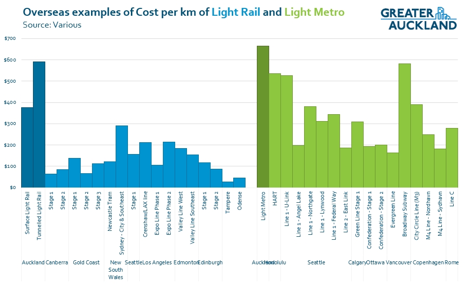
The costs have be converted to NZ dollars and inflated to 2021 values.
There’s also the issue that ALR say the cost figures given so far have an of accuracy of around -50% to +60%. That means the two tunnelled options could potentially end up costing $23-26 billion.
I’ve gone through the history of this project many times before, and a couple of months ago we outlined in a lot of detail how we would recommend progressing light-rail, making a series of staged expansions that ultimately deliver light-rail to many parts of Auckland.

Light rail to many parts of Auckland
Even with the expensive ‘per km’ surface costing above, the project could be expanded to include the Northwest Line to Westgate and most of the crosstown route – for about the same price as the light metro option on just the CC2M corridor. It would be fascinating to see how that combined network would score in an assessment against the tunnelled options.
How can we get this network focused concept off the page and into the ground with nationwide buy-in, avoiding the fate of the Northern Pathway? By not pouring the entirety of our investment into one single corridor.
The key will be to emphasise that we can (and we must) incrementally develop a rapid transit network. One that – along with the existing rail network and other planned rapid transit projects like the Eastern Busway – covers all major parts of Auckland.
To do this, the Government needs to make the first step a realistic one – something with a cost that’s in the region of comparable international projects and doesn’t use up all available money for decades to come.
At the same time, the Government also needs to clearly outline how this first incremental step will ultimately work towards a fantastic and constantly evolving rapid transit network for Auckland. A network that will, over the coming decades, support and shape its growth, allow many more people to move around the city congestion free, and contribute to a transformational reduction in vehicle travel and emissions.
This surely means the ‘tunnelled light rail’ and ‘light metro’ are simply over-scaled and too expensive to be smart first stages. A single line that cost $14-16 billion but that could end up in excess of $20 billion is too much and with too much risk for a city Auckland’s size, especially when we have so many other transport investment needs such as long overdue networks of bus and bike lanes.
It also means we need to find ways to sensibly reduce the cost of the surface light-rail option – at least its first stage. It seems there is an assumption by ALR that whatever system is chosen here must be the same as eventually crosses the harbour. That needn’t be the case at all. In fact, if you put surface light rail on Queen St you preserve an ideal underground crosstown route perpendicular to the CRL under Wellesley St, which in future can run to the North Shore and use any form of rail that’s most appropriate at that point in time.
In other words, light rail here doesn’t preclude light metro there. “Future proofing” doesn’t mean making every future decision now, it means not closing possible futures off.
Indeed, future-proofing can be best achieved by returning to some key features of AT’s original surface light rail option from the middle of last decade:
- Staying within the existing Dominion Road corridor, thus avoiding the need to buy and demolish so many properties – ALR suggested 489 properties were needed for their surface option
- Keep a faster and more efficient route through Mangere while still serving Mangere Town Centre. This will ‘make back’ the additional time from travelling at surface along Dominion Road rather than being in a tunnel.
- Looking at staging the project, as part of a comprehensive plan to incrementally develop Auckland’s rapid transit network. Very few cities build 20+ km long rapid transit projects in one go – they usually start with a viable inner section and then slowly expand it outwards.
- Recognising that tunnelling, rather than ‘avoiding disruption’, involves a longer construction period at larger scale, and huge complex work sites (see: CRL). No project is without disruption – but the ALR seems to have misjudged the public appetite for massive numbers of trucks transporting tunnel spoil on our streets over many, many years.
- Acknowledge that tunnelling also doesn’t deliver the good kind of “disruption” enjoyed by cities that add surface light rail. Not only would it leave our arterials the traffic and bus-dominated places they are today, we’d also miss out on the permanently transformed streetscapes, the people-focused thriving communities around local stops, the benefits of having public transport in the open, a moving billboard of a better way to get around that is attractive and accessible for everyone, including children, the elderly, and visitors to our city.
Next are the issues around delivery and here too there are surely opportunities for transformation. With rapid transit, bike networks, and urban transformations now coming to more parts of Auckland, Wellington, and hopefully other cities too, we will need more competence and focus in these fields both locally and nationally.
Decisions have not yet been made on a delivery entity for the project, with either a new company or Waka Kotahi being considered as options.

In theory, delivering this kind of project should be the job of Waka Kotahi – after all, our national transport agency should be the ones building nationally significant transport infrastructure. But with Waka Kotahi seeming to spoil everything it touches in recent years (Northern Pathway and previous iterations of light rail come to mind, alongside massive NZUP cost blowouts and appalling slowly progress on improving safety) I’m not so sure.
With both Auckland and Wellington looking at rapid transit, and possibly other cities eventually too, perhaps the government should look to establish a national rapid transit delivery group that can plan and deliver a pipeline of light rail and busway projects around the country. This could help in bringing costs down, speeding up delivery and ensure common minimum quality standards for all systems.
We are so close to a fantastic outcome here, one that will change our city permanently and proportionately. But the Government will need to avoid the pitfalls it’s fallen into over transport projects in recent years.
Ultimately, the Government should make clear that surface light rail is the Goldilocks choice (“just right”, in terms of scale, deliverability, and speed at which we’ll see benefits). Then it should set a strict budget that’s well below the $9 billion and much more in line with international benchmarks – even if that requires a few trade-offs to the design or sequencing. It also wouldn’t hurt to insist on getting much better quality advice in the future.
If the government can do this, and then work through design details (like station locations) at pace and with much less secrecy, then – hopefully – we will get a great project that’s successfully underway in a couple of years.

 Processing...
I can see a case for all public passenger transport, both local and long distance whether rail, road or water, under one government/central controlling body.
This would enable better delivery with the ability to bring scale to purchasing and cost as well as creating one large fully integrated system.
Would stop the problem with funding for PT inexorably leaking into the Road Activity Class. WK’s Accounting Jazz hands.
Remember 10-15 years ago, when activists dreamed about having one central body that would oversee all transport – road, PT, cycling, walking – in Auckland? One that could do “joined-up planning”?
We got that. It’s called AT. Now we wish we hadn’t.
Not quite true, we just wish they’d taken the zealousness and efficiency taken to road renewals and applied it to creating cycling infrastructure.
And not dissolved the cycling team. (There are probably other things, but it’s too early in the day to be hating on an omni-shambles)
I agree with Robert. Currently, ‘turn up & go’ public transport services in NZ is disorganised and uncoordinated due to the regionalisation and commercialised operating model that is being applied to funding and procurement of public transport services within regions with some region’s having little or no public transport services. The slow bureaucratic decision making of NZTA that regional councils have to go through, is also not helping.
If NZ is to meet its zero emission goals by reducing non essential car use, all public transport planning and funding needs to be separated from NZTA and be placed in a dedicated national public transport agency under the Ministry of Transport, to formulate operating standards, long term planning, funding and procurement of public transport services, whether it is bus, light/heavy passenger rail and ferry services for all 16 regions in NZ, in association with the agency’s city, district. regional councils and transport provider partners.
Being a crown entity, the National Public Transport Agency would have the ability for greater purchasing power of standardised public transport assets and lease or sell them to local or national transport providers whether they are owned by private or council own companies/entities.
Given the current leadership has built such a great track-record of capable management – centralising makes total sense?
What I seeking is a transparent process of developing criteria that can be used to build an integrated transport plan including –
traffic management – including a coordinated system of traffic light management,
cost effective distribution of road space between modes of transport rather than dogma driven ideologies taking precedence.
coordination of connectivity and timetables of current PT options based upon passenger demand – current and planned
then building the infrastructure to meet those needs where the benefits of doing so adequately mean it is reasonable to do so.
Let’s call it the “Three Modes (of transport) Reform” 😉
DaveH.
Got to say I love your response, and it’s probably a good analogy with three waters and those that see their little fiefdom being dismantled rather than the public good.
Has there actually been any pushback in the media about the outrageous costs? Or any long for writing about the history of this project and how the scale has gotten out of control? Most people probably have just seen the headline and had a laugh, without realising there are actually realistic options to get this done
Please stop talking about surface light rail as “rapid transit”. It will never be rapid if it shares the road. It is, at best, mass transit.
It won’t share the road, it runs on its own corridor
I can see an Albany to Airport metro being amazing for Auckland, much better than two separate lines terminating in the city. They are currently spending $5 billion to make heavy rail pass through the city instead of terminating due to the many advantages it gives.
I also imagine the NW LR line sharing the Dominion LR line tunnels in the city. Without that would both lines use Queen Street? And would that seriously limit frequency?
If you consider LR as a network including the North Shore, NW and Airport lines, probably 80% of it would be metro grade regardless (everything except city and Dominion Road). I can definitely see the case for tunneling that last 20%.
To me surface level is starting to sound like the worst option. If they are going to go “cheap”, why not go with decent electric buses.
We can add city tunnels later, that’s part of the point. We don’t need to do everything in one go as trying to do so makes the project more risky and unaffordable.
Doing it this way also helps to build ridership, encourage mode-shift faster and at the end of the day, we will always need something on the surface on Dominion Rd and something on the surface in the city centre so it’s not like this will be a wasted investment.
Wouldn’t bus be a better interim option though? Fully electric and much bigger and nicer than the current ones of course. The cheapest they can do LR infra on Dominion and Queen is say $2 billion, but they could do fairly decent bus for say $100 million. And they could do it in a year instead of 10.
There’s already buses, tripping over each other, jamming the city centre, and no improved streetscape on their streets. Queen plus Dominion, nearly dead straight, in centre of the Isthmus catchment, is the perfect surface light rail route. That will never change, even, or especially, as more rapid transit lines are added to meet induced demand. There’s no waste in doing this first, and much benefit.
We have a city of bus improvement opportunities on other streets.
These corridors are the critical ones for light rail, which needs to get started so that Aucklanders can see it for themselves, discussion moves out of the theoretical, and the sector starts to build up expertise.
Just because the current bus situation is bad that doesn’t mean it can’t be a lot better. If each bus was bigger (articulated), and if the bus lanes were truly continuous and 24×7, and if the Dominion Road buses used Queen Street and didn’t share Symonds Street with millions of other buses, and if the buses were electric instead of smelly noisy diesel, and if the buses had traffic light priority, then the only real difference between bus and LR is the maximum capacity. Maybe have a policy that 3×100 seat buses travel in convoy at peak times, then the capacity and frequency would be roughly the same wouldn’t it?
Any sort of bus, including BRT multiple unit, won’t have the capacity needed for the Dominion Road route. This includes finding platform length in the city centre for all the other buses passing through, even with the new city centre bus plan.
I would support doing some thing in one year rather than waiting ten. Electric buses seem good but its a very long route if its going to run on the Northern Busway as well so it might need some on route charging. Being able to make a trip between the Shore and Mangere or Onehunga without transferring might suit some people who have never used a bus in their lives. Not a bad idea as I am running out of patience with the endless secretive light rail process.
I have regularly ridden the Albany to airport Skybus and there is nothing about the level of patronage and frequency of service that suggests that a one trip metro is necessary. People can and do handle transfers.
The North Shore should (probably) ultimately be light metro but that is because largely the track space is already seperated.
The Skybus is only about the airport, I’m more thinking about the stops in between. Albany to K Road or Mt Roskill, Onehunga to Takapuna, etc. Yes you could transfer, but is does add time, especially at Auckland frequencies.
And there is also the problem of terminating 3 lines in the city, this will take up space and severely limit capacity. And surely terminating North Shore underground in the city will be expensive, a much bigger underground station required, probably 4+ platforms.
Transferring is fine, especially at the frequencies Auckland will have.
Heidi I disagree with the statement “Transferring is Fine”. My daily journey often involves a big man with a limiting limb sweating as he runs for the bus his transfer requires . If he misses it it is a 2 hour wait. He has injured himself at least twice getting on and off a bus. The problem with frequent services is it makes transfers more complex and slow. Heathrow is spends more to help transferring but Wellington Airport is still faster. Transfers take, time, effort, resources, are physically challenging. Efforts to make them easier, or possibly avoid them altogether are something which should always be on the mind.
Transfers are how networks work. If you’re not happy with transfers the case we’re discussing here – between two long lines – you’re not supporting a network approach. A whole lot of long lines from point a to point b is how cars work. But not PT.
Transfers are fine, because otherwise PT doesn’t function. Accessibility for people with reduced mobility is not achieved by getting rid of transfers, because that puts paid to having a PT network at all. It is achieved by designing every step of the journey with accessibility in mind. This means by changing land use significant, and creating the most direct active mode connections as possible, and using best practice technology and design.
The 2 hour wait is the problem right there. Services with that sort of headway are either one seat, or they don’t exist.
What frequencies will we have anyway? Off peak right now is a mix between 15 and 30 minutes, which still pretty much doesn’t work. Are we going to get 10 minute headways in the future? Not quite turn up and go, but probably just good enough.
I am worried that street level light rails maximum volume per hour is low. 5000 people per hour is 30% lower than what the Northern Busway has reached.
Isn’t that because we’re starting form a point of SOV dominance?
Parts of Melbourne’s tram network don’t have any priority and other sections with higher levels of service do have separation and priority, they’ve picked the priority and level of service that match the outcome required.
Teething problems aside, once everyone gets used to the system, priority can be enhanced as branches and coverage increase, otherwise we’ll end up with highly expensive small parts of a system, which is I think what Matt is talking about.
5,000 an hour is one large vehicle every six or seven minutes.
That’s not the maximum volume for surface rail, that’s about half the maximum.
Seattle is doing 4-car trains. Each can hold 194 people (250 at “crush”). That would be 15,000 people/hour per direction ( or 20,000 at crush ) with 3 minutes spacing between trains.
That is the volume stated in the Auckland Light Rail Groups surface running plan. I agree it is low but how is it handling intersections? One would hope the light rail would be unimpeeded but without the details it is hard to know.
Hi Simon. If you run LR on the streets and it takes one minute for the train to move through an intersection each train will take 1/3 of the intersection time. Two directions makes two thirds of the time. I do not see the corner of Balmoral and Dominion working with only 1/3 of the time available for cars
Two directions makes two thirds of the time.
Its bi-directional track, they would be likely to overlap, and be going through opposite directions in the same phase. And that phase may line up with other pedestrian / vehicle directions too.
ie, center running LR in the center 2 lanes going straight, combined straight and left turns for cars. Or straight for pedestrians too.
“If you run LR on the streets and it takes one minute for the train to move through an intersection”
Why would it take 1 minute?
A 66m long LR train at 40 km/h passing through10m of intersection will take a shade under 7 seconds to clear the intersection. This will not cause the total collapse of car-centric civilisation as we know it.
Waiukuain, it takes a lot less than a minute for a vehicle to cross an intersection, even a very long light rail train. And the likes of the green light for Dominion Road crossing Balmoral Road already has most of the signal time for general traffic and buses.
This isn’t revolutionary stuff, it’s what they already do in dozens of cities with surface light rail every day. Perhaps you should take a trip to see first hand, you only need to go so far as the Gold Coast, canberra, Newcastle, Sydney, Melbourne or Adelaide.
Dominion Road during peak times is lucky to do 900 vehicles an hour, and most of those hold only one person.
Sorry rechecked Auckland Light rail City Centre to Mangere Rapid Transit document page 33 graph
6,250 per hour for surface
11,500 per hour for metro
12,750 for tunneled light rail
The best the Northern Busway has achieved so far is 6,800 per hour
Those numbers are arbitrarily low. Looks they’re the maximum they think they need, but they’re not the maximum each mode can carry.
There must be something fundementally wrong with the process, and the pool of people selected to be advisors that continually comes up with world leading, in costs solutions to Aucklands transport problems.
The system, has in a relitively short time span produced proposals for the East West roading link, A foot and cycle bridge across the harbour, and now a single Rapid Transit Route for the Auckland isthimus, that have all been distinguished by being world leading in expense.
This has lead to common sense dictating that the first two schemes have been dropped in entirety, and I fear the same fate may befall the current proposed Isthimus Rapid Transit scheme.
A huge amount of money gets expended, and the not insignificant problems remain unsolved.
What is required is not “the best solution” but only “adequate solutions”, but a lot lot more of them. It is counter productive to commit all the resources to solving one problem thus delaying fixing a multitude of problems.
Focusing on a best solution for a single corridor distracts from the real task of fixing the transport and emission problems city wide.
There must be something fundamentally wrong with the way we are defining the problem to be fixed and setting the parameters, and then selecting the advisors.
I suspect here, that the Government is sheltering far to much behind advisors, rather then clearly laying out exactly what the objectives are and where they fit in the big picture of transforming Auckland on so many levels.
The Three Waters Proposal, is refreshing where, like it or not, that Minister, has clearly signalled that it will unambiguously be a government led process.
I agree. We run the risk of repeating the mistake of Robbies rapid rail which was considered far too expensive in part, because it included the “ ideal” solution of increasing the track gauge to the entire rail network.
Tunneled LR just makes no sense… it basically costs the same as LM but with lower capacity, slower and not automated.
Surface LR is a whole other animal and elevated LR is a feasible option, but you might as well go LM in that case.
Yes. Three options means you’re supposed to choose the middle one, right?
This: “the government should look to establish a national rapid transit delivery group that can plan and deliver a pipeline of light rail and busway projects around the country. This could help in bringing costs down, speeding up delivery and ensure common minimum quality standards for all systems.”
We need a Light Rail Industrial Complex rather than a road Road ROAD Industrial Complex. By building up capacity, expertise, and knowledge we can bring Light Rail back to our major cities. Yes “back” – Auckland and especially Christchurch were built around their tram networks.
A staged rollout of Light Rail routes across Auckland would benefit Christchurch, Hamilton, and Tauranga immensely. A new national LRIC organisation with a mandate to build 10 routes throughout NZ over 20 years would signal the need for private and public investment and the costs would come down. Land planning would clarify density requirements, and it would be easier to value-capture from the uptick in denser Transport Oriented Development enabled by clear route decisions now.
Building one-off mega projects is absolutely the wrong thing to do. So where next for the CRL expertise? – an inner city rail station for Christchurch! I jest but that is more sensible than wasting the resources we have built up for the CRL. Don’t make the mistake with Light Rail. A National Policy Statement for Light Rail please.
It would be a good time, too, to overhaul our appointments process, which is holding back progress.
David I – I agree with you. See https://publictransportforum.nz/initiatives#national-public-transport-agency
David – “Auckland and especially Christchurch were built around their tram networks” – not just them ! NZ also built the cities of Napier, New Plymouth, Wellington, Whanganui, Gisborne, Dunedin and even Invercargill around trams. They even had trams down the West Coast of the South Island for quite a time.
But yes, you’re right in saying that we really need a Light Rail specialisation to be started in New Zealand. Starting a long time after the rest of the world, but it does need to be got underway now. In my mind, the place to start would be to look to the countries that have been doing it successfully and less expensively – to Spain, for instance, or to Korea, rather than to Britain or Australia. They have people there in Spain that know ho two get it done, on time, on budget, and for a budget far, far less than the nonsense being talked about in those graphs Matt has posted above.
I do not agree with this blog’s criticism of the suggested route through Māngere. As has been stated before on this blog, getting rapid transit to the airport is not the priority. Improving access to an area currently underserved by PT should be celebrated. This is an area currently reliant on private vehicles to access employment. From the 2018 census results, 84% of commutes were by private car, nearly 17% above the regional average. It’s really disappointing to see the blog suggesting this community be more excluded just to shave a few minutes off trips to the Airport for the more affluent communities in the central city.
It still runs through Mangere either way. If it runs along Coronation Drive it serves Mangere better, if it runs along the motorway it serves Favona better.
Yes, but the Coronation Rd-Bader drive route has increased walking catchment and links in better with the Māngere housing development
It doesn’t appear to be worth committing LR to having a driver on board to me. If they’re going to go to the expense of tunnelling on the isthmus then it should stay off street for the entire journey.
Kruss, it’s not improving access to the area that’s important for the residents of Mangere, it’s improving access *from* the area.
If you make that detour then everyone from Mangere has a longer and slower trip to get anywhere, which means they can get to less places.
The number of people that get a slightly quicker trip from a tram stop in their street will be much smaller than the number that come to Mangere town cente to catch it by bus, bike and walking from further away and have a longer trip.
You’re absolutely right about the importance of the area, and we’re focused on a solution that serves Mangere best. We don’t think that is achieved via creating a wiggly route to the current town centre. Rather, we think the whole area needs far more focus, with crosstown buses and quality transfers, an extensive safe cycling network, and regeneration of the streetscapes and public spaces. A more direct route connecting a revitalised Mangere is part of our more ambitious visioning for the area, not less.
The current main bus stop at Mangere Town centre is about 400 metres from the motorway. Almost close enough and on the 36 and 38 bus route. I suppose all bus routes could be adjusted to arrange a connection with light rail. Still light rail would be cool. But if it saved a billion then its probably not worth it.
I’m just hoping this discussion can stay positive and support Matt’s post in general, so Michael Wood can see a sensible, positive contribution to the current issue.
With the current climate where the central govt wants to control the narrative on most things ,DHB,s and Three Waters come to mind,they risk the perception of “Nanny State”, if another national body is formed.
Having said that, though, the regional DHB,s are a mess,leading to poor quality health outcomes,and water control and delivery is patchy at best,so maybe with our low overall population,central control is the best option.
Normally l would be dead against this idea,but l find that having our indigenous people involved in the decision making process,which latterly they are, normally leads to decent outcomes for all
I don’t think trying to make up extra speed in Mangere is ideal. I’m inclined to agree with the Minister, that it’s a choice.
The project seems incredibly slow in general… looking at your table and using some estimates of where Midtown, Mt Roskill and so on are defined to be, then it has average speeds of:
35km/h between Midtown and Mt Roskill for the tunnelled options
30km/h between Mangere and Mt Roskill for both light rail options
11.5km/h between Wynyard Quarter and Midtown for the surface LR
21km/h between Wynyard Quarter and Midtown for the tunnelled options
Mind you, the same process tells me Orakei to Britomart averages 38km/h and Parnell to Britomart 24km/h based on the timetables.
37 minutes from Mangere to Midtown isn’t meaningfully different to 32 minutes. I mean, yes, 32 minutes to Midtown is more or less what Middlemore will be doing post-CRL, but 37 minutes is equivalent to Papatoetoe. Effectively, Mangere will have a level of service with such of time equivalent to being only one/two stations further away. (The equivalent Midtown to Bader Dr distance is between Otahuhu and Middlemore.)
Is five minutes to actually enter Mangere really worth so much?
What’s more is that you can gain those five minutes back through building the crosstown route (via Mt Albert).
The distance from Onehunga Train Station to Mt Albert Train Station is 10km or so. That means we have 11 minutes to Onehunga (from Mangere) + 20 minutes to Mt Albert + 26 minutes to Swanson = 57 minutes. If we then apply the same 18% speed increase I used when thinking about Mill Rd busses versus an A2B transfer, we get 53-57 minutes.
In comparison, if you do the same thing assuming a tunnelled LR with a transfer at Kingsland, then you get using 35km/h perhaps 28 minutes to Kingsland, for 62 minutes total. Add in an 18% speed improvement and that’s 56-62 minutes.
The money saved by not doing a tunnelled option would allow for a crosstown route all the way to Coyle Park. (Using the $375M/km figure.) And there’d be $417 million left over… which might be enough to convert the Onehunga Line to LR, I don’t know.
There are quite a few people out west who work around the Airport. So they’re not really any worse off provided the crosstown route is built.
I find it hard to imagine people in Mangere are worse off having light rail be 500 metres closer to them, so they might even be better off (and the crosstown absolutely improves access to the rest of Auckland as opposed to just the north/south direction).
People in Favona are losing out, though. I guess the location of the parks swung it… if you’re in SH20 then you’ve got these unoccupied greenspaces on both sides. But on the face of it, they’ve got to travel an extra 500 metres and cross the whole width of a motorway to get to LR now.
Mind you… the difference between the two tunnelled versions is mostly the route south of Dominion Rd. If you take the difference in jobs within 45 minutes of Mangere between the two versions, there’s a huge difference of 106,600. If you take the difference in jobs within 45 minutes of central city and the airport, the difference is about half that. But even 50,000 seems enormous.
Obviously, we’d prefer a catchment based analysis a la the old study (and comparisons between Bader Dr and SH20 options for surface LR), but jobs figures is what we were given.
Once you realise that the crosstown is affordable for the same price, most of the stuff the ALR Board’s report talks about just seems like rubbish they came up with to tip the scale.
My overwhelming impression is that they’re completely convinced North Shore LR will happen, that it will happen via a tunnel and therefore that it’s necessary to judge these options based on the North Shore LR. Effectively, then, the two tunnelled routes are two projects priced at one versus a single project fairly priced… that coincidentally could become two projects for the price of one tunnelled version.
If you’re prepared to spend $14b, spend $14b to do two things that accomplish the same goals as one thing plus more, instead of building one thing that may or may not end up dovetailing with a different project.
“Once you realise that the crosstown is affordable for the same price, most of the stuff the ALR Board’s report talks about just seems like rubbish they came up with to tip the scale.”
It’s disappointingly skewed and random.
I still don’t get why the fixation with CC2M first. NW seems the logical first choice. Can be staged out to Westgate (and further but after Westgate you aren’t running on motorway land) and terminate at Mercury Lane/CRL until patronage grows (like the Eastern Busway). The corridor is mostly already public land, bar the land for the stations.
You’d require a bit of land at the city end, possibly a house or two for access for Bond St station, the petrol station opposite Motat, some land in the Pt Chev centre, and space for a proper interchange station at Te Atatu. Then it can be staged further as construction proceeds. You could even have the maintenance facilities at Motat (would require track laid across GNR) in the short term until the line reached an area with cheaper land for a depot.
Once it’s working and shows its a good option, you can build both the metro style CC2M and trams down Dominion to link up, but that’d be a long term thing.
For $14bn you could do that and the A2B at the same time probably….
Why the Pt Chev Centre? Just use the existing space which appears on Google Maps to be a carpark behind the shops.
This is a rapid transit connection to the West, it needs to follow the motorway corridor closely as possible. Diverting into the inner suburbs will slow it down and add time, we can’t afford to run it up Great North Road.
Agreed 100%. I’m imagining the route as only along the motorway corridor, the locations I was mentioning were the spaces for stations/station development. Re Pt Chev, agreed, but to my knowledge (haven’t checked) that carpark land is private. Also there might need to be private land taken further along going under Carrington Rd, but that’s more of an engineering issue weaving through/around the Waterview Connection. I think the most sensible option is stopping at the carpark, then under Carrington, to a bridge over and around the interchange, then along the causeway (elevated/taking a car lane/reclaiming the marine reserve all have their pros and cons)
The carpark at Pt Chev is public land and is intended to be used for a station.
@Heidi
Good to hear, makes things easier. Is it intended for a station in a plan or something/is there any further reading on it?
I remember our supermarket was also likely to make a move (the arcade said they were looking at RSA a while ago) so I thought there was a possibility that the supermarket might’ve owned that land.
Or I should say, is “available” to be used for a station, and as far as I know, was intended to be used for a station a few years ago.
Using the carpark for the station was common knowledge back in about 2018 but I can’t find anything amongst my placemaking project documents to pin down who’d said what about it. The LB members might know more, as I think they might have had briefings. Matt wrote a post on Light Rail in Pt Chevalier here, although it doesn’t exactly confirm where the station would be: https://www.greaterauckland.org.nz/2018/08/13/light-rail-pt-chevalier/
I don’t imagine they got as far as publishing any plan.
Pinning down the supermarkets’ changing intentions has been a game of cat and mouse too; I vaguely remember each of the major brands had intentions in Pt Chev at different times. One of them intended to launch into owning their own properties but it didn’t go so well in Grey Lynn, so they pulled back.
I can’t remember if the RSA was considering the supermarket idea before or after their quite developed plans for a new RSA club room facing the motorway, day care facing north, and apartments above… it was a pity that didn’t proceed. There was a neighbouring apartment development that looked pretty swish. I think the RSA opposed them for not having enough parking spaces. In any case, it didn’t go ahead either.
@Heidi 2.0
Yeah, these were only stories I heard from people who had shops in the arcade (who were naturally not fans as it took customers away), and they were referring to the current countdown moving (we aren’t fans of the layout even if its improved so generally shop at Grey Lynn – evidently it’s a common thing which is why they were looking at it). Bar the library/square (and maybe the old bank) I’d be happy with the whole shops being bowled and rebuilt with something better.
I wasn’t actually picturing a station where your link had it, as seems far less space than the KFC carpark, but we’ve got a good centre/good people with terrible buildings, so they could probably redevelop it into a good station. But it would be on a fairly busy (and unpleasant while walking) intersection with all the motorway noise.
Yes, the shoppers’ carpark (KFC carpark) is where most people are imagining the station. I was imagining a high rise building on that, with ground floor station facilities with walkways to actual platforms closer to Carrington Rd but I never mapped it out to check the viability of the walkways.
Panuku did a study of community needs recently, with the Council facilities (community centre, daycare, shoppers’ carpark by the mall) in mind for redevelopment. I think that land, too, should be rolled into a full redesign of the block. There has been significant work done on engaging the public at different times, but the nature of the multiple ownership of the mall is preventing anything coming of it. (I was told many were overseas owners but I had confirmed recently that no, they’re all in NZ. Also that a developer had recently approached them to sell but they didn’t all agree.)
I thought we might have done a post on capping over the motorway at Pt Chev to reconnect the north and south parts, but maybe we just discussed it. In any case, these are quite fun:
https://www.greaterauckland.org.nz/2009/09/09/capping-spaghetti-junction/
https://www.greaterauckland.org.nz/2018/06/06/use-stadium-to-fix-aucklands-scar/
And this one’s interesting too:
https://www.greaterauckland.org.nz/2014/06/25/the-unitec-opportunity/
Really disappointing that the three sites on Huia Rd where three houses were removed, opposite the shoppers’ carpark, are not being used wisely. They’re just doing two story townhouses.
@Heidi 3.0
Makes sense locations wise. The station itself’s exact location/configuration as long as it’s easily accessible into the centre I’m not too precious on at present. I think there is some heritage value in some of that block (evidently one was maybe an old cinema or something) but I’d be happy with most of it bowled and whatever heritage aspects earthquake strengthened and incorporated into the design. For the supermarket block, I’d be happy with a full redevelopment as well.
I’m not sure if I like the idea of capping the motorway initially. Not because its not a good idea, but because then it makes it way harder to pick the borders of Pt Chev. Currently it’s just motorway and Meola Creek. Also capping the motorway is one of those projects that the longer it gets, the more sensible it becomes. A pedestrian bridge reconnecting Parr Rd and a connection between Rawalpindi and Henry Louis (never been on this one) seems to make sense in the short run instead.
The value of land in Pt Chev seems to be going in one direction, and land next to the centre of its value in the future I would expect to be worth more than now, meaning the project would make more sense then. There would be cost inflation, but also capping becomes more common across the world, the difficulty of such a project should decrease. Also I think it’d devalue the revamp of the centre (more supply) and increase the cost of the project too much. Hence being a later stage.
Once Mercury Lane comes online, capping Spaghetti makes more sense. Again though, would prefer NW first as just another complication the capping would have, rather than the other way (or including it in the same project, as NWs merits are being far cheaper/easier than the other ones.
If you built NW LR and extended the train from Onehunga to Mangere then after they were working in the RTN you could add in a slow tram squeezed into Dominion Road (although it would be a stretch to call in rapid). You wouldn’t need tunnels or widening and maybe it could be built at the international costs noted above.
I think in the long run all of these will be needed, and given none of these seem like they’re going to be started (let alone completed) in the short term.
I think Dominion Rd is more trouble than it’s worth until the local community pushes for it, as they seem to be wanting big pay outs/stopping anything they don’t want. Another big reason for NW being a better option, as far less scope for public complaints (unless they want to bulldoze the trees like they tried with St Lukes last time, then I see a lot of them). Especially terminating at Mercury Lane initially, you can avoid the city centre issues for another 10 years or so.
I think the fixation with the southwest first is that it’s already a very busy and underserved area, and while the northwest isn’t great currently it’s quite a bit smaller population and the problems really come when all the growth starts to happen further out over the next two decades… although at this rate both will be built out by the time anything opens.
Interestingly with the recent housing announcements, greenfields growth is actually set to slow quite a lot. Apparently PWC think most people would genuinely prefer a townhouse or apartment further in. I for sure would.
The impending doom of the northwest may be mostly mitigated. Although that leaves existing residents, and the smaller number that will build there still with bad transport.
Best advertisements for Rapid Transit is seeing them speeding past congested traffic. It’s great with the Southern Line, and even better with the Northern Busway. Dominion Rd you have that already with the bus-lanes sometimes, while on the Northwestern you don’t really.
With the NW you can rearrange the whole NW PT network like the Northern if the spine is solid. Dominion removes buses, NW removes buses and vastly changes the rest of the buses to improved routes.
We have a busway under sonstruction on the NW motorway right now. That bus will fly past traffic and the whole network is going to be reorganised around it.
@Sailor Boy
The ‘busway’ isn’t a busway. It is literally a few bus stops, and there is not bus priority in the areas that need it, e.g. past St Lukes towards the city (apparently that’s planned now). It’s kinda an insult towards busways to call disjointed shoulder bus lanes and a couple of stops on the side of the motorway to be a busway, when we have actual busways like the Northern, Eastern and even the Airport to Puhinui one being closer. Also AT doesn’t regard it as rapid transit their NW busway improvements, and specifically refers to it not being a busway.
It’s odd that you are happy to call the airport to Puhinui route a busway when:
a) it has bog standard bus stops
b) it has bog standard bus lanes
c) it has sections with no bus lanes at all
The northern busway also has dedicated lanes for less than half of it’s length.
It’s probably because busway is an amorphous term with no set boundaries to its meaning
The best advertisement for Rapid Transit is transit that is frequent and fast. Buses down the shoulder of the northwest motorway will be both. This is a great, low cost intervention that dramatically improves PT and builds demand for an even better solution.
@Sailor Boy 2.0
I called it closer re the Airport – Puhinui one – just as it seems to cover more of the route. I think you’re right though so I’ll withdraw calling it similar to a busway.
I think the NW improvements are good for the interim, and I’m happy they’re doing it. They’ll be needed as even in a perfect world LR isn’t built instantly and a lot of the places for the bus stops eventually might become LR stations as they need to stop in similar areas.
Just I wish for them to be starting efforts for LR (or another non-bus mode) in that direction now as well, and I disagreed with it being called a busway as I don’t think it’s deserving of the name. I also don’t think they’ll fly past, shoulder lanes aren’t exactly high speed in general in my experience (much faster than the near stationary traffic though)
Yeah. I reckon these motorway shoulders should only be called busways if they’re part of the Congestion Free Network.
Which they are not: the Auckland Motorway Alliance still treats the shoulders as breakdown lanes.
Anyone know why this has been branded as light rail?
I know if either a street run or a seperated tunnel route is chosen it will be a dedicated passenger rail line, so engineered for lighter loads (no freight) hence light rail.
It is true most light rail systems run larger EMU trains in width and length then our new CAF EMU sets.
But most people associate Light rail with little street cars or trams, I know those are just one of many forms of light rail, but the branding won’t help sell this to the non transport nerd’s.
If the government are wanting to build a new passenger rail line why not just call it Auckland metro or south west line.
Is the light rail branding to separate it from our current metro network which also Carry freight which makes it a heavy rail network.
Or just a hangover from AT deciding not to extend the Onehunga line but to run a new passenger line instead.
What would you call it instead?
I’m not sure that Light Rail really means much to the general public, you see in all the media that they’re at a loss to tell everyone it’s a tram. Even the government is telling people one option is a tram like Melbourne, for some reason.
If it keeps to the original plan I would call it dominion line or mount Roskill line.
If the tunnel option is chosen maybe south west line or Auckland metro 2 or airport line.
Now most people outside of central Auckland will see 9 billion for a street car as a rip off and think this won’t help me get to the airport.
The tunnel option despite it’s price excites me more as I know it will be a system worth extending beyond central Auckland.
But I also just whish they would just build the street car line on dominion road and down Queen st and be done with it.
Auckland Transport called it the southwest line, that’s pretty good for any of them.
The formal costings presented are very strange and it is difficult not to think that they have been pitched in a way to ultimately doom light rail on financial grounds.
It looks like depending on what your final cost would end up as, this project would cost between half to around two thirds as much as the entire Crossrail project did, which at the time was the largest infrastructure project in Europe. Remember that Crossrail has 40km or so of tunnels under London and the trains will stop at 40 odd stations of which ten have been built from scratch. That light rail in Auckland would cost half as much to build as that just doesn’t seem possible. Who would believe Treasury would sign off on it? Oh well. We’ll see.