Tomorrow (Tuesday 31 August), the consultation for the Auckland Light Rail process closes. If you haven’t already, now’s a good time to provide some feedback.
We’ve been somewhat critical of this engagement process due to a lack of information about some of the key trade-offs that need to be made. Why, for example, has the public not seen details that we know the ALR team has, about things like comparative costs, station locations, or travel times? On the other hand, we’ve been impressed by some of the communications material. It sets a clear, inviting, and wide vision for what light rail might mean for Tāmaki Makaurau. These are the kinds of comms we’d also love to see for the entire PT and bike network – not to mention the nationwide climate action response.


Vision is one thing; actually building it is another. We’ve been following the light rail discussion closely since it first kicked off at the start of 2015. We’ve read stacks of reports and papers looking at the issues and the options, which has helped shape our views on the topic. While we don’t have any more detailed information on the plans currently being looked at, that doesn’t stop us from sharing our thoughts on what we think light rail should be.
With this post, I thought I’d lay out the Greater Auckland vision for how we think light rail should be developed in Auckland – the full picture, not just the City Centre to Mangere (CC2M) line that’s being consulted on right now.
A Greater Auckland vision for light rail
As a quick reminder, some of the key questions/decisions that need to be made are highlighted in this image from the ALR team.
![]()
Building a light rail network, or even a single line like CC2M, isn’t something that’ll happen in one go. So I’ll break this down into what we think are appropriate stages, allowing for some parts of the project to be progressed while other parts are in planning and design phases. (The exact order and timing of some of the later stages may be interchangeable or could even happen at the same time.)
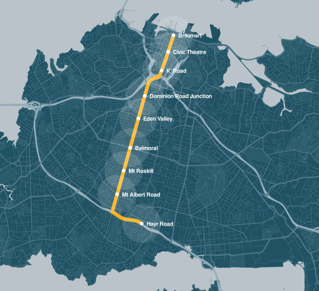
Stage 1 – City Centre to Mt Roskill
For the first stage, we should build a surface light rail route from the central city and across the isthmus: from bottom of Queen St, out along Dominion Rd to around Hayr Rd in Hillsborough/Mt Roskill. A few key points to why we think this.
The Mode
We think surface-level light rail should be chosen. There are a few reasons for this:
- It is a much cheaper option. As I’ve highlighted recently, based on overseas experience a cost of $150 million per km would be a conservative estimate for light rail but light metro is more likely to be $500 million per km or more. That means for the ~9km route a cost of $1.35 billion for light rail compared to $4.5 billion for light metro.
- For all that cost difference, it doesn’t actually make much difference to travel times. A travel time model I’ve built suggests it would take about 18 minutes to get from the Civic/Aotea to Hayr Rd on light rail compared to about 14 minutes for light metro. The light rail option includes maximum speeds of just 30km/h on Queen St and 40km/h on Dominion Rd. However, the light metro time doesn’t include it would take to get down into or out of underground stations so the actual difference would only really be a couple of minutes at most.
- With a light metro solution, the higher costs for underground stations means we’ll have fewer station and therefore wider station spacing. That means we’ll still need to run buses on the surface to fill in the gaps.
- A surface route is likely to involve less disruption during construction. Overseas examples suggest it is likely to take about three years to build a surface route. Even Sydney’s beleaguered project only took four years. By comparison, light metro (raised or tunneled) would likely take six to eight or more years in a realistic scenario – we only need to look at the length and level of disruption of the City Rail Link project to see this won’t be fast. Imagine that replicated all the way down Dominion Rd.
- And, for those using the service – which is kind of the whole point – surface-level is much more accessible to more sorts of people, of all abilities. As Women in Urbanism have pointed out, because street-level stops don’t require stairs or elevators to get to a station, they provide easy journeys for anyone with pushchairs or wheelchairs or accompanying children or even just shopping. You can see and be seen, which adds to the comfort and appeal of city travel.
We’ve heard concerns from some officials about the long-term passenger capacity of surface light rail. As well as expanding the network even greater than suggested here, this could also be addressed with even longer light rail vehicles. Lengths of up to 90m to 120m are starting to be seen on some systems overseas such as Seattle (up to four 29m trains) and Dallas (up to three 37.5m trains).
The Route
Dominion Rd makes the most sense for a light rail route because it is the most direct and has a number of well-established town centres. We know Sandringham Road is also being looked at, but why duplicate the Western (rail) Line? It’s hard to see why Kingsland would need to be served by high-frequency heavy and light rail routes.
The only apparent reason for Sandringham Rd is the potential for Kainga Ora development along the route, but we feel that can be dealt with separately. There’s just as much capacity for development on the Dominion Rd route if the zoning is changed to enable it – which it should be.
As for stations, there’s always a need to strike a balance between speed and accessibility. For this first stage we think a good balance is nine stations, serving the local town centres and providing good coverage while also keeping travel times competitive.
The Wynyard Question
Previous plans and the current process have suggested light rail will go to Wynyard Quarter. We think that for Stage 1 it should end at Customs St. Customs St is a key bus corridor and will become even more so in the future with Auckland Transport’s City Centre Bus Plan. Extending light rail to Wynyard will limit the number of buses able to use Customs St including important routes like the NX1.
The City Centre Bus Plan
Light rail should integrate with the network we have, not run rough-shod over it. So we feel the time to look at extending light rail to Wynyard would be in conjunction with plans for extending it to the North Shore.
In addition, not extending to Wynyard could save about $250 million – reducing the sticker shock of the project, and likely making it easier to get over the line with the public and government.
The other end (and depot)
We think Hayr Rd is a good location to end the first stage, as it keeps things fairly straightforward before getting to the trickier part of getting down the hill to Onehunga.
There is also a good potential depot location nearby in the light commercial area around Carr Rd – a decent portion of which is already in government ownership. This is only a short distance from Hayr Rd, which provides access across the motorway, meaning a station there would have a wide catchment from nearby residential areas. This spot also connects to the current 27W buses, useful for those living around the Mt Eden Rd corridor when the light rail route is extended to Mangere and the Airport.
Why start in the city?
Over the years we’ve seen suggestions of starting by building light rail somewhere else, such as from the airport to Onehunga. While these locations need light rail, previous work has suggested they won’t be the busiest sections.
Everyone is invested in a successful start for the next phase of Auckland’s transport network. The best way to build confidence and ensure buy-in to the big plan is for the first stage to be a success from Day One. And to our minds, the best chance of that happening is with a route serving the isthmus and busy city centre from Day One.
However, it would be useful to start enabling works for other parts of the route, such starting to build the Manukau Harbour Crossing, to make it easier to build the later stages.
Green Track Dominion Rd
We would also build light rail on Dominion Rd with green tracks.
Green tracks in Barcelona, Spain (left) and Grenoble, France (right)
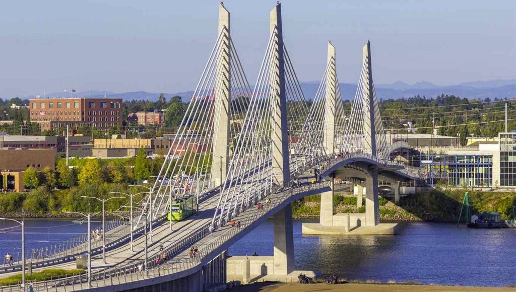
Stage 2 – A New Harbour Crossing
As we’ve discussed in the past, we think the next Waitematā harbour crossing should be a combined public transport and active mode bridge, similar to the Tilikum Crossing in Portland. We think this should run between Wynyard Quarter and the old toll plaza south of Onewa Rd. Work on this needs to start now, as it will take time to design and consent and to provide an active mode crossing as soon as possible. If there’s a gap between when the bridge is finished and when it’s time to extend light rail to the Shore, we could use the vehicle space initially to provide a dedicated space for buses.
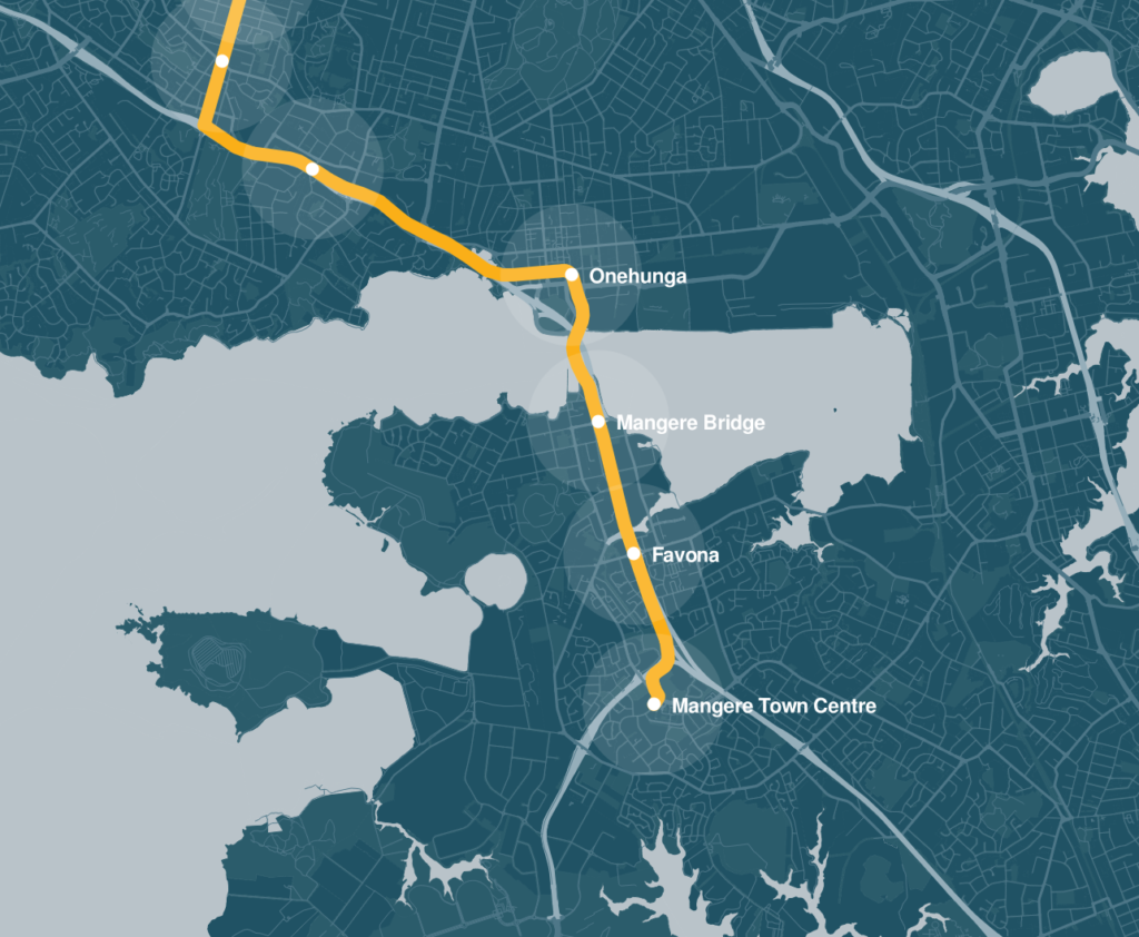
Stage 3 – Mt Roskill to Mangere
This would see light rail extended from Hayr Rd to Mangere Town Centre. We think this should largely stick to the SH20 corridor, with the exception of deviations into Onehunga and Mangere Town Centre. Overall this would add 4 stations to the network.
There are a couple of key reasons for leaving this section for later. Firstly, unlike the initial section which is mainly on existing roads or in the unused Avondale to Southdown rail corridor, Roskill to Mangere may require acquisition of new/additional land in which to build light rail.
Secondly, there are a couple of more technically tricky sections, such as getting down from Hillsborough Rd to Onehunga, a new bridge across the Manukau Harbour crossing, and getting through the SH20/20A junction and into Mangere. Separating this stage out means the first stage can be progressed sooner while the design and planning work for this stage goes ahead.
Motorway or local roads?
We’ve heard suggestions in the past about sending light rail along Bader Drive in order to serve Kainga Ora sites. We think light rail should stick to the motorway corridor for faster journeys, and also so light rail can serve as a catalyst for development on the western side of the motorway – and best serve communities on both sides of the m’way equally well. Some additional active mode crossings of the motorway will help in this regard, to reduce severance.
Mangere Town Centre
Previous plans for light rail have suggested a station in the motorway corridor around Bader Dr. This would be a faster option, but a short deviation to the town centre won’t add much trip time. Furthermore, the Light Rail team have already shared an image showing light rail serving Mangere Town Centre, which will have raised expectations in that community.

Stage 4 – Mangere to Airport
We’ve separated this section out from the one above in order to make it more manageable. Also, while it is a key employment hub, a huge question mark hangs over the airport precinct, including whether the Airport itself will support (and invest in) light rail within its boundaries and on a rational route. Traditionally they’ve not been brilliant at integrating public and active transport into their planning. Therefore, the Mangere to airport section is better left until the airport’s planning is aligned with the city’s plans.
We think there could be three stations here:
- Montgomerie Rd to help serve some of the local industrial area,
- Airport business area just north of the airport
- Airport terminal
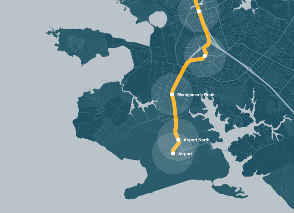
For those worried about travel times, this route should be about 37 minutes to get from The Civic to the airport
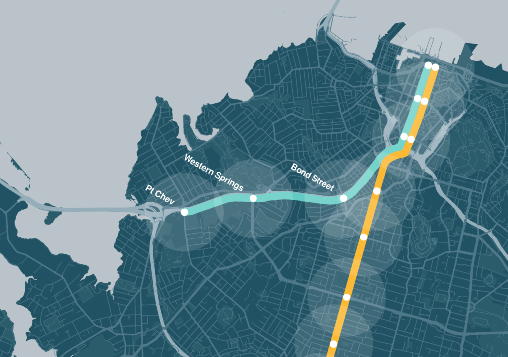
Stage 5 – City Centre to Pt Chevalier
Interim bus improvements to the Northwest are on the way and they’ll be useful for improving public transport in the short term but long term the Northwest needs a permanent option.
The full vision as set out in ATAP is for a light rail network that also serves the Northwest. To get that started we envision light rail branching off from the CC2M route around Newton Rd and crossing over the motorway. It would then run alongside the motorway as far as Pt Chevalier with three stations.
- The Pt Chevalier station would be immediately east of Carrington Rd and would help serve the proposed Unitec development. It would also allow for connections to the Outer Link and 66 frequent buses.
- A station could also go in around St Lukes Rd which could link to a frequent 65 bus. This station would give access to Motat, Western Springs Park, and the Zoo, as well as residential areas north and south of the motorway. The motorway ramps may need to be reconfigured a bit here.
- The third station would be at either Arch Hill, perhaps with a elevator up to Gt North Rd, or at Bond St (shown below) which could provide links to the 20 frequent bus for access to Ponsonby, Wynyard or Kingsland.
Stage 6 – Pt Chevalier to Westgate
The tricky part here is getting across the causeway. The cheapest and easiest option for this would be to convert a couple of motorway lanes, especially as once road pricing and light rail is in place there should less demand on the corridor. New stations would be added at Te Atatu, Lincoln Rd, Royal Rd and Westgate.
With light rail Westgate would only take around 25 minutes to get to the middle of the city centre.
Potentially an additional station could be added between Royal Rd and Lincoln Rd, say at Huruhuru Rd.
Stage 7 – Crosstown
As I wrote about recently, we think one of the advantages of going with a surface route is it opens the opportunity for a crosstown route which would open up trips from the west to the southern isthmus. It would also help in serving the Kainga Ora land around Hendon Ave and the end of Sandringham Rd. See that post for more on this proposal – it would also replace the Onehunga branch giving it much better frequency and capacity while also simplifying the heavy rail network.
Stage 8 – North Shore
It is currently expected that following some enhancements to the Northern Busway, it should have enough capacity through till the mid-2030s, which is why it’s near the end of our list today.
Once light rail is ready to be extended to the Shore, it would travel along Fanshawe St and through Wynyard to join the new bridge. It would then replace the existing Northern Busway, while a separate branch would go to Takapuna.
Replacing the busway wouldn’t be without its challenges given how busy the buses will be, but I’m sure some clever engineers and planners can come up with a better solution than just building a parallel route.
Stage 9 – Westgate to Kumeu
The Northwest line could then be extended to Huapai with three additional stations. Brigham Creek would help in serving the new developments around Whenuapai via a bus transfer, while the stations in Kumeu and Huapai would serve the area.

With light rail Huapai would be just 35 minutes from the city.
Bringing it all together
After building all of this, here’s what we get for our light rail network. This is of course in addition to the heavy rail network as well as the Eastern Busway and Airport to Botany Busway. That’s something that would really live up to the vision promised in the light rail comms.

And once this network is built, there are all sorts of options for where to build more of it.
As a final reminder, the current consultation for light rail closes tomorrow.

 Processing...
Fantastic, great to see an actual plan with some detail! This is really just an update of your old CFN2 plan then? I love the green track and the extra line.
What’s the capacity then, is it enough?
Should there be a station at the top of Rosebank Peninsula? It’s strikes me there’s a whole lot of people there who could get to and from work by light rail. I appreciate it’s a fairly small catchment.
Seems a no-brainer combined with a shuttle bus that goes between there and Avondale station to ferry workers up and down the road?
As with the other light rail projects, it seems that a light railway to the Rosebank Peninsula will be planned and then shelved repeatedly.
@Hiker Why Rosebank? It’s a low-density, primarily industrial area.
Extending crosstown light rail from Avondale to Pt Chev would in all likelihood be a better option.
Costs of a station vs just having the 138 travelling a short distance on the motorway to the Te Atatu interchange. I think it could be an option later on, just in the short term not worth the cost for a small number of passengers to have a 5 minute quicker trip.
The question is where exactly would the station go and how would you get the trains and buses to it. It looks hard/impossible in the real world context.
Compare that to just taking the buses a little further to the Te Atatu Station, which would be built anyway.
Should I be reluctant to buy a house besidd the motorway if train link will be added as I may not be able to resell my property
Yes you should be reluctant to buy a house beside the motorway, but you’re more likely to be impacted by motorway widening.
Sorry, dumb question, but I assume light rail can cope with significant slope eg. Running up that Hill (Queen Street)
Yes, easily.
It did 70 years ago.
In Sheffield in the UK, their light rail system has a sustained 1 in 10 (10%) gradient, including a station halfway up it.
If only….
But why doesn’t stage 1 just go to Onehunga all the way? Afraid of cannibalising the train?
Did you read the post? It answers your question.
Also, not even a mention of A2B being light rail at any point? And extending it from Botany to Panmure?
Demand on those corridors is well within what can be easily handled by buses.
Imagine an optional loop terminus branch where each motorway line could reach out towards town centre. Say if northwestern line were to have a looping terminus along Lincoln Rd towards Henderson town centre (essentially creating an ALR and current rail interchange) with a loop back up via Te Atatu South before heading backtowards CC; same thing could be done with Westgate/Redhill/Massey West looping back via Royal Road.
Kumeu/Huapai area could be covered under an upgrade to current rail line instead of extending the ALR to be a commuter line.
They’re called feeder buses and work really well.
+1, if we are going to build LRT on those roads, they should be proper crosstown services, not umpteen branches off of the main line.
I’m intrigued that you propose “green tracks” for the route down Dominion Road, which appears to be quite full of cars at present. So that cars are not driving along leaving muddy ruts in the green road, I presume you plan to ban any cars from the centre two lanes, and relegate cars and trucks to the kerbside lanes, where the intermittent bus route is now. Is that really going to work? Or am I missing something?
Wouldn’t it be simpler to have a dual use surface like they do in Zurich, Prague, Bratislava etc, where there are tram lanes, but cars can venture into them at times when needed? Aren’t “green tracks” really just a piece of PR puffery?
The plans from AT are for dedicated LRT lanes that cars can’t drive on. Whether those are grass or concrete doesn’t change them. Cars go on the lanes either side.
If you let people drive on the tracks they’ll do it constantly with a huge queue at every intersection, and the trains will be even worse than buses for reliability.
It’s obvious isn’t it, cars on the outside lane where the bus lanes are now. Get rid of on road parking obviously
I never understood why they put the LR on the centre lanes, surely it is much nicer to move the cars as far from the footpath as possible, and stations would work better too. What is the advantage of centre running? Just so they can keep the side streets open to cars? Most of them could be closed off (accessed from the other end) couldn’t they?
Surely centre running is the obvious choice? With centre running, cars on the road can slow, stop, turn left at any time without causing crashes. The LR running down the centre of the road causes very few traffic clashes, except at the major road crossings of course. But having LR running down the outside lanes, such as buses do at present, would cause mayhem. LR can’t stop as quickly as a bus – people stepping out from the pavement, cars turning across the LR traffic route, all potential traffic catastrophes waiting to happen.
The plan is absolutely not to close of side streets. That would force a lot of traffic off the arterial and through neighbourhoods. “Rat running” and is expressly not intended. We want to decrease the need for traffic sure, but not like that.
The car traffic on the outer lanes means all left turning car movements are non conflicting with the LRT, and so are the straight along dominion road movements.
Centre running is the standard pretty much.
“That would force a lot of traffic off the arterial and through neighbourhoods”: wouldn’t it force access via Sandringham and Mt Eden instead of Dominion? Why allow a left turn but not a right?
I would say they should signalise some and close the rest.
The multitude of driveways along Dominion Rd seems like reason alone not to have tracks on the left side of the road.
Jezza’s driveway comment, is a good one, I mind blanked and forgot about that one. This alone is enough to ensure the left hand lane car running.
We will have to add more lights though (probably), to have some right turn / u turn abilities.
Right turns are always disruptive, left turns don’t have to be, so why would you make them?
Thanks, hadn’t thought of driveways, I can see why now.
Kraut – it may be obvious to you, but I’m not sure that either you or Matt have thought through the consequences fully. Yes, running tracks down the centre is what is being proposed, but at present (forgive me if I’m wrong) there is some stopping / parking allowed in some sections of the road – particularly out of work hours. Certainly the bus has been weaving in and out of the left hand lane whenever I’ve taken a bus down there. Having dedicated tracks down the centre removes that possibility forever.
And re green tracks vs concrete pathway – those pictures from Barcelona and Grenoble are surely very different from what is proposed for Auckland? The green tracks there appear to be running through a heavily tree-filled environment, with a pedestrian footpath next to the Light Rail tracks. That’s very different to being next to a heavily used lane of cars and trucks running through a tight corridor between Light Rail and a continuous row of small shops and houses. A single breakdown of a single car in either direction would cause traffic havoc. Maybe that is a good thing, and maybe that is what is wanted, but I suspect that if that was publicly stated then howls of outrage against this scheme would be heard over the whole isthmus. Auckland needs LR but it needs to be honest about what that will entail. That’s why Twyford’s plans were sunk so rapidly – the proposals shown to the public were widely derided for being overly optimistic.
The stopping & parking, for mostly for loading bays and some shop parking would be in the side streets, its never more than 50 meters away from most points on the street. Compared to mall distances that seems perfectly reasonable.
The buildings that need loading zone and customer parking access inherently have 20m + of commercial building into the side street, so I doubt people would complain about it being directly in front of their house.
My retort for the breakdowns is there are plenty of other places to break down in the city that are equally bad. I have personally been in a car in rush hour symonds street that broke down. In the time we managed to push it (onto the footpath in the end, shoot me) less than 10 cars managed to get through the busses around us in the bus lane. It wasnt gridlock, and didn’t impact the overall city’s traffic. I think the breakdown issue is overstated. It could arguably be even less impactful on traffic, simply because there will be less of it. The other end argument / example is the motorway, where a breakdown in one of 5 lanes backs up for kms for many more vehicles. Whereas here it’d be far fewer vehicles.
Tyfords plans were a self own, he did the real damage himself. There’s always going to be poo-pooing articles (some more credible than others sure)
Just saying, average human: you sound like *you* want to sink any plans that don’t center the planning on the car movements.
Break downs are one thing but the key will be fire engine access. Another is oversized vehicles. I can’t see the green strip being allowed
Caitlin – re: “you sound like *you* want to sink any plans that don’t center the planning on the car”
No, you’ve read me wrong. I absolutely, totally, 100% want it to succeed, hence I’m saying that for any proposal to succeed, it has to be a watertight solution that everyone will say Yes to. Anything that is wooly, or unclear, or not justifiable, will get the whole scheme thrown out, just like the slightly ridiculous $685million cycle path over the harbour. Propose something silly in any way and the whole project gets shafted. Whatever is proposed here in Auckland for Light Rail absolutely has to have a complete plausible solution. Hence my questioning if green grass down the middle of this road is really the right thing to be doing.
You make the fiction that critics of Light Rail have promulgated i.e. that it is just a tram system. It will run on dedicated tracks with signaling priority. Traffic runs outsider of it. Dominion Road is largely free of buses because LR replaces them.
Nice wish list. What’s the supply of magic dust like under Level 4? You don’t really have a timeline but allude to North Shore (Stage 8) being needed in the 2030’s. Given Akl’s track record on delivery I’d be astounded if we’d managed to get to Stage 5 by then and not overly surprised if only Stage 1 is complete.
I’d love to see all this completed in my lifetime but I’m a realist and don’t expect it will be. Sadly I don’t think millenials will see this in place
I reckon all this could happen quite quickly if we could just break our societal addiction to the private car. I.e. if everyone or most people could get on board with the concept of minimising or eliminating their personal or household car use, as I have managed to do for the last several decades. Of course this change becomes much more realistic if it is encouraged and facilitated by national and local government.
If a critical mass of people is not prepared to do this and not willing to support government initiatives to facilitate it, then the transition process out of car-dependency and towards an alternative paradigm will be laboured and fraught.
While you argue that starting from the city end would enable the concept of Light Rail being seen to being a success from day one would come from that, I’m more inclined to suggest that starting from the Airport and pushing out in to directions, to Mangere and on to Onehunga and via Puhinui Station to Manukau and then on through to Botany, given that Te Irirangi Dr was designed to have light rail added.
By connecting Botany via Manukau, Puhinui and the Airport to Onehunga you achieve two things, one is servicing a large catchment area not well serviced plus set up a working trial system that can be used to show how efficient light rail is and from that you will get far more buy in to having it run down Dominion Rd (or Sandringham Rd).
The only even slightly busy station on your routes (without connectivity to the city) would be the airport, and that is assuming flights get back to normal. Compared to Dominion Road where every station will be busy. So I think that would have the opposite effect, it could make it look like a white elephant.
Based on current loadings you would probably be right, BUT!
By connecting Botany and Manukau with Puhinui Station you get a strong possibility of good loading numbers and then extending through the Airport Industrial precinct and on the Mangere you then connect those area together and once again create the demand needed before you even continue over the Manukau Harbour and on to Onehunga.
While these services are being built a lot more work can be put in to just how to get the Onehunga to Auckland Central line route defined rather than just assuming that Dominion Rd or Sandringham Rd are the likely options.
While Dominion Rd is heavily congested at present, and the building of any line along it will present major headaches for businesses along it, it is also true to say that the present bus only option is currently giving reasonable service where the connections to and through the airport precinct services are in need of at best a review.
A2B is another one where we should get on with BRT. I agree it will have a lot of latent demand given it links two big employment hubs and is currently starved of any rapid transport. So better to get the quickest RTN in and have that delivering ASAP. I see this as like the Northern Busway; it will eventually be rail, but you can probably get 20yrs of effective use in the interim via BRT.
In saying that, I fear you are right about the challenge of getting it into Dom Rd. Maybe the time, money and effort should have gone into putting a line on the NW Motorway, rather than the sub-optimal bus route we are getting in 5yrs time…
I can’t believe you don’t have a station at Roskill South on the city line. That is within walking distance to a large amount of development. Also where will people transfer from the current 25 bus routes? Mt Roskill? Is there room there?
Yes there’s room. The plan was for a bus interchange behind the Mt Roskill shops.
OK. But it is currently another 5 minutes or so to go that extra few hundred meters by bus in rush hour. Although I imagine they would use May Road instead as there won’t be room for bus lanes on Dominion, but then is even room for bus lanes on May Road.
Personally I think it would be better to make the 25B and 25L one frequent route from Lynfield to Blockhouse Bay (and extend to Green Bay) that has a stop at a Roskill South LR station. I can’t see the need for a big interchange as long as their is a single route and the LR is not the final destination.
Mt Roskill shops is a great place for a bus interchange as lots of people want to go there anyway. Roskill South just doesn’t have the walk up catchment to justify a station. Maybe if Akarana golf course was turned into housing things could be different.
Kainga Ora are building lots near Roskill South: https://roskilldevelopment.co.nz/neighbourhood/roskill-south/
That’s all at least a kilometre from the closest part of the line. Those folks will need to use the bus.
While I like this article and the outlined network I just have to devil’s advocate arguments:
1)
“And, for those using the service – which is kind of the whole point – surface-level is much more accessible to more sorts of people, of all abilities. As Women in Urbanism have pointed out, because street-level stops don’t require stairs or elevators to get to a station, they provide easy journeys for anyone with pushchairs or wheelchairs or accompanying children ”
vs
“We think light rail should stick to the motorway corridor for faster journeys, and also so light rail can serve as a catalyst for development on the western side of the motorway. Some additional active mode crossings of the motorway will help in this regard, to reduce severance.”
Not very clear when is speed the preferred outcome and when is easy accessibility the preferred outcome? 😉
2)
“It is currently expected that following some enhancements to the Northern Busway, it should have enough capacity through till the mid-2030s, which is why it’s near the end of our list today.”
There won’t be any LR work starting before the mid-2030’s, so this is no argument to put it at the end of the list.
Final comment:
Was wondering when you would put up another rail article. Those see the best engagement on the site.
(Also won’t be submitting since I live in Wlg and we have of course our own LGWM consultation agency.)
1) Speed and accessibility; speed serves people too. As Matt has discussed, the extra walking up and down to stations required for Metro means its apparent speed benefit gets whittled away for actual users – while its accessibility is much worse. Choosing direct routes on the other hand – that then link into a complementary bus network that allows regeneration over a large area – improves speed, access and liveability, without any compromise of accessibility.
2) Timing depends on leadership. I think your pessimism about no LR work starting until the mid-2030’s is based on past performance. Let’s see if we’ll be served better now than we have been. If everyone plans for a slow start, that will be self-fulfilling. If they still haven’t got anything underway in five years, then maybe we revisit the NS… but everywhere else will be in even more of a pickle.
I agree with your point 1 that there are inconsistences with time v connection to street based activity. It has always annoyed me that it seems there is one rule for the well-off isthmus and then another for the poorer areas of Mangere.
I would also extend this line of thinking to really push back on the need to take Light Rail to Kumeu where there are large swathes of urban areas not serviced. I would sooner go to Hobsonville Point than Kume. Manukau Road to Royal Oak, add a Mangere Road link from Mangere town centre to Middlemore, Botany etc.
The Isthmus and Mangere situations are totally different. If there were a motorway corridor running through the central isthmus do you think Greater Auckland would advocate for a route that ran mostly parallel but 200 meters away in the side streets so that now it serves only one side of the motorway? Or on space within the existing corridor serving both sides, and is faster, and less disruptive.
+1
Central AKL is sorted for PT whereas the working class areas of South Auckland that is so important to NZ Inc (often forgotten about by homeworking pen pushers), would benefit so much more.
Look at London, LR is in the suburbs, not inside zones 1-3.
“Look at London, LR is in the suburbs, not inside zones 1-3.”
London has extensive underground and overground rail systems serving most of the region including the city centre. This includes the Docklands Light Rail, which in-effect is light metro.
On-street light rail in London is restricted to the Croydon-Wimbledon area south of the city, where coverage by conventional rail was poor.
The main radial routes out of Auckland’s CBD are beyond what can reasonably be expected of on-street light rail, and require their own fully-segregated corridors. While on-street light rail to Mt Roskill or Onehunga would be feasible, expecting this to act as an arterial route to the city for large areas of South Auckland is unrealistic. Same with the North Shore and the North West. These major areas need proper, segregated rail to the CBD.
Did you read this proposal, which includes ‘proper, segregated rail to the CBD’ from the north and north west?
I’m also interested to hear that you think this line will be so popular that 15,000 pax per hour (750 per 99 metre vehicle every 3 minutes) of inbound capacity from the SW won’t be enough. That’s about what the entire rail network did pre covid.
Sailor Boy, what I read was “from bottom of Queen St, out along Dominion Rd”. That sounds like on-street to me. Or are these streets to be completely fenced-off to turn them into fully-segregated rail corridors?
Are you claiming that on-street LRT can handle 15,000pph? Well perhaps it can, if it is fully fenced-off and nothing or no-one else is allowed access. For normal on-street LRT, 5,000pph is a pragmatic maximum to design for. This would be a moderately-full Bombardier Flexity or Alsthom Citadis with 250pax , coming every 3 minutes (You would not design a system to rely on max crush-loading routinely).
How many on-street LRT corridors are you able to cite which routinely exceed this? (yes, there are indeed a few)
I’m glad that you mentioned flexity:
“The tram can be coupled to form several-car trainsets, enabling an overall capacity of more than 20,000 passengers per hour, per direction.
https://rail.bombardier.com/en/solutions-and-technologies/urban/tram-and-light-rail.html#:~:text=FLEXITY%20Freedom%20%2D%20Edmonton%2C%20Canada&text=The%2041.9%20m%20long%20light,will%20ensure%20rapid%20passenger%20flow.
This post itself mentioned 100m long vehicles and the 30m long flexity carries over 250. So that matches my proposed capacity of 750 people. I.e. more than the entire heavy rail network did until a few years ago, except that this capacity is for both directions.
https://en.wikipedia.org/wiki/Bombardier_Flexity_Freedom
I can’t believe that you are seriously suggesting that Auckland’s city centre urgently needs more capacity that would be offered by double tracked light rail and double tracked heavy rail through running the city centre. That’s capacity for 70,000 people in and 70,000 people out in peak hour.
Sure, in 30 year we might need more than that, but we should be building more lines, not maxing out every line that we do build.
Sailor Boy, where in the world will you find 100m-long trams running at 3-minute intervals (in both directions) down a narrow public street like Queen St? That is what you will need for 15,000pph.
Sure, these high-end capacity figures are theoretically possible, but to achieve them the street has to become a virtual rail corridor and loses any ambience as a traffic-free pedestrian space. That’s like having a pedestrian mall on the approach tracks to Britomart. Very few urban LRT systems will try to shove this kind of intensity down a typical inner-city street. Those that do will be busy planning tunnels to restore peace above.
@Dave B & @Sailor Boy
Yes rather than maxing out a Queen St line, we could have another Nelson St Line coming from the west (this line could split to Great North Rd from an original motorway running one that joins up to the Queen St one).
My experience with the public transport system in Portland, Oregon is that the trams travel relatively sedately through the the city centre but pick up speed through the tunnel and out on to the flat country beyond the hills (forget the name) and where the right of way becomes more dedicated than in the centre. And I don’t see where we can’t do the same, so Matts comments are quite ok.
The two things aren’t inconsistent, they are both focused on quick and reliable travel times but in different ways because Dominion road and Mangere are very different contexts. That part of the isthmus is dense, compact and with a street network designed before cars were invented for walking to trams on the main road.
Mangere is low density, dispersed and has streets and urban form designed for motor vehicles.
The rail line and stations should have different designs to do different things to respond to different conditions along its length.
I’d love to see the rationale for the separate line to Takapuna. I regularly use public transport and I don’t get it.
It would be staged just as the Manukau station was opened 137 years after Papakura opened. So if the North Shore Light Rail opens in 2040 the Takapuna line would be some time around the year 2177.
Miffy
Yours is the best answer so far.
I am concerned the Takapuna line is a vanity project.
The thing to consider is that a Takapuna branch is only 1.4km extra track once you’ve gone to the north shore already, it’s low cost for quite high benefit. Like that add on crosstown line. While it probably involves a bridge in the larger scheme it’s a tiny amount of extra track to tie in a main centre and bus interchange, not least one with a nice beach and other advantages.
The should do the same thing with Albany central and the university up there.
Riccardo
one that is better served by buses that have a way better catchment than a single light rail line up the middle of Takapuna. On Matt’s costing over $200 mill. That buys a hell of a lot of bus trips.
The important thing is to look at the land zoned for terrace housing/apartments. The Amaia -200 odd apartments – is not walking distance to this proposed light rail, as is much of that zoning. It would just make no sense to run the existing bus schedules on Anzac and Esmonde as well a tram up the middle – the worst of both worlds with high capital and operating expenses.
This light rail does not serve trips near the metropolitan centre well and they are likely to be much more frequent than cross town trips. Having said that a bus station at Onewa makes great sense.
And accessing the beach? Use the NEX services to Akoranga and then choose one of the many services that go up Anzac; or if AT was committed to a network, high frequency 82 services that went up Esmonde. It’s a better result with a lot less operating expenses and no capital.
Light rail is unlikely to fix the frequency issue that plagues the 82 at night If a 60 seat service only runs every half hour how frequent will a 200 seat tram be?
Yes it might be better served by a bus, the existing bus is obviously the cheapest and easiest. But again if you build a busway spur to do the same thing it’s probably not much cheaper.
Catchment wise I don’t know what you mean, from Takapuna to the city there is basically no catchment other than Takapuna itself. A light rail line would have the benefit of connecting to Akoranga station, which most buses don’t, and the new Onewa station, tying in to the whole west of the shore… then running right through the CBD and out to west, or maybe even down all the way to the airport.
Takapuna is well served by buses from it’s immediate surroundings and from the eastern side of the north shore. It’s not well served from the western side, or from anywhere south of the harbour. The light rail would go a long way to fixing that.
The Amaia is absolutely within walking distance of the proposed light rail, it’s 650m walk from Akoranga station. If you had an intermediate stop somewhere on Barry’s Point Road it would be less than 500m away.
And it would serve the metro centre very well. Assuming the station is somewhere in the middle of lake road or just nearby, it would have the entire metro centre and THAB zoned area within 800m walk of the station.
The light rail would run every five to ten minutes at all times, if it was the end of one of the main lines like GA has shown it.
IMHO the North Shore light rail should initially be a line running from Smales Farm Busway station via Takapuna CBD to the Devonport wharf to connect with an improved ferry service.
From there the system can be extended north along the existing Busway, south also on the Busway and via a new bridge or tunnel to the Auckland CBD and west to Birkenhead and maybe even use that route as the connection to the Auckland CBD or to continue on through Birkdale and Beachhaven and across to Hobsonville to join up with the proposed line along the Western motorway.
How did you make the maps?
Please, does anyone know how to make maps like that?
I’ve been trying to bolster my argument for why the 371 is badly designed and what should be done to fix it (i.e. something other than replacing it with AT Local), but my inability to produce graphics like that has proved a real hindrance.
With free vector graphics software such as Inkscape, you could take one of AT’s PDF route maps and edit it.
https://twitter.com/scootfoundation/status/1432068263438028800?s=21
Scoot on Twitter made them. I asked him a while ago about how he makes maps. Qgis was the answer, I had a go and downloaded it myself. Didn’t make much progress but I didn’t try very hard. Maybe you could find some tutorials online. And for tricky data specific stuff maybe you could ask him on Twitter. Seems pretty reachable. Good luck
(If you’re reading this scoot, I also love the maps, great colour choices)
Thanks for the article Matt. People get caught in criticism of specifics that is sometimes fair enough, but overall I think this is the most logical progression of events.
One minor point would be that potential development capacity under a future light rail route along Dom Road compared to Sandringham Road is only equivalent in theory. In reality, the consolidated KO landholdings at Sandringham Road allows for more development on larger, amalgamated sites by a single org who is motivated to develop. Small, individual landholdings will always be restricted to some extent by the cadastre, landowner motivation, skill and financing ability.
If that is true, should KO be paying a contribution towards public transit as part of them realising their plans?
ATAP is supposed to capture this, with the urban planning aspects impacting the transport infrastructure. How do we confirm the links and relationships between the two?
Thankfully the NPS-UD (and whatever it’s successor would be under the new RM system) requires council to up-zone to at least six storeys any land around a rapid transport stops, so by putting in light rail, up-zoning will follow. This will likely lead to development by the private sector, as we are now seeing in other areas where they are aggerating property. And if they don’t, there’s always the powers under the Urban Development Act that can be used as a catalyst to get some of these areas intensifying.
Can KO do very high density though? I think they know state housing apartments don’t work very well. They will mostly build 2 and 3 story I imagine.
kainga Ora don’t have to (and don’t) exclusively build state houses. They can also build to sell, and build for market rental. They could build apartment buildings with 10-20% state housing.
Not sure that would go down well: demolish state houses and replace them with market rentals.
I used to live near a state housing area. I definitely wouldn’t want to share an elevator with a lot of them.
I also lived in the UK for a bit, the “council estates” were not very nice places (apart from those since privatised).
It’s happening as we speak in Glen Innes and Panmure.
Right now, as we speak, old, damp state houses are being demolished and replaced with a larger number of state houses and market rentals. it’s going down pretty well as New Zealand is desperately short of homes.
The UK council housing had social issues precisely because the UK built large tracts of exclusively state housing in areas that were really isolated. The UK haven learnt from this and new council homes are apartments in mixed hosing developments right on top of train stations. I am saying that Kainga Ora should build mixed model housing in accessible areas, such as Roskill South.
Really? Yes they are building market and kiwibuild houses as well as state houses, but there is no loss of total state housing or state apartments to my knowledge. The density is higher than it was, but not exactly high.
Yep, believe it or not, replacing a single house with 6 gives you quite a lot of leeway. Going from super low density to low density still gives you a big jump.
https://kaingaora.govt.nz/about-us/addressing-housing-demand/
Beyond Westgate why not run LR east Hobsonville and perhaps across to Whenuapai, rather than 10 km further along the motorway corridor to Kumeu / Huapai?
After all there already is a HR line through Kumeu / Huapai, which could easily be electrified (all the way out to Helensville) and it should be only an hour or so to the city post CRL. It could even be sped up with shorter dwell times at stations (that old chestnut), fewer level crossings. People commute by rail for much longer journey times in Wellington, and for that matter all over Europe.
Send LR where HR is never going to go, get more bang for our buck.
Huapai to Britomart via the existing HR Western Line would take around an hour, even after the CRL is opened and even with shorter dwell times.
Northwestern Light Rail, as outlined above, would take around 35 minutes – much quicker and much more competitive compared with driving. It would also connect Huapai with the closest metropolitan centre (Westgate).
Your stats don’t bear out, Matt Bear…
Swanson to Newmarket is 44 mins today; Swanson to Aotea post CRL is the same. Huapai is 13 km from Swanson with one stop. Huapai to Aotea should be under an hour before any improvements.
And neither does your logic…
Building LR to Kumeu / Huapai comes at the cost of not building it to Hobsonville, Whenuapai. These are major population centres.
We don’t have an unlimited pot of funds. So build LR where HR doesn’t go.
How do my stats not “bear out”?
Swanson to Huapai is around 15km. That’s not far off the 18km distance between Papakura & Pukekohe (which takes 16-17 minutes by the DMU shuttle), so it’s safe to presume due to the lower speeds and more curves Swanson to Huapai would take 15-20 minutes by heavy rail.
Add that to the current Western Line timetable, and Britomart-Huapai would take around 75 minutes. Add that to the post-CRL timetable, and Aotea-Huapai would take around 60 minutes. Your calculations don’t seem correct at all.
In terms of a wider network, there’s probably more benefit in a crosstown Constellation-Hobsonville-Henderson “upper harbour” RTN line (either BRT or light rail). For citybound Hobsonville residents, changing between high-frequency services would only be a couple of minutes slower than a single-seat journey – plus a crosstown route would encourage more jobs in the metropolitan centres of Albany, Westgate, and Henderson.
That’s before any extra stations too, Certainly you’d add Waitakere.
Well it’s 13 km not 15 km, with one stop much of it in a straight line… with our EMUs that has to be 15 mins at most, even with two stops. Add1 min at Swanson and the existing 44 mins the train currently takes to Newmarket (which is further away than Aotea and with a very low speed corner) = 60 mins max.
How long a 50 year old DMU takes to go 18 km isn’t really relevant is it?
The things is, since we know that people will travel 60 mins one stop by train in Wellington and all around the world, it’s very likely they’d do it in Kumeu / Huapai.
Yes, build a cross town Upper Harbour line. Build another line along Manukau Road, or the Botany line or wherever. No doubt we will need all of the above at some point. Anywhere except where there is already HR.
it’s over 14.5 kilometres from Swanson station to Tapu Road, where you would want your station.
Why do you want a 60 minute trip instead of 35, the only possible explanation is mode fixation. You don’t actually want good transport, you want heavy rail regardless of cost or benefit.
I second what Sailor Boy is saying. Even in the best case scenario, heavy rail from Huapai to the central city would take nearly twice as long as light rail along the Northwestern Motorway corridor.
Just because “heavy rail is already there” doesn’t mean it’s automatically the best choice and “what we must use”. There are other factors to consider – not just distance and journey time, but also expense, other catchments, and connectivity.
Light rail all the way to Huapai would give Huapai residents more travel options. Someone could change at Westgate to get to the North Shore or Henderson, for example, given an Upper Harbour BRT/LRT line. Or someone could get from Huapai to Pt Chev without needing any transfers.
It’s 13 km to Kumeu town centre, 14 km to Tapu Road. Best being the enemy of the good here.. an hour to the city.
35 mins to the city via all new LR.. maybe? Or 40 mins? Plus getting to/from the stations at either end, say 2x 10 mins so a typical overall journey time is about a third longer. And maybe that could be less with shorter dwell times (one day…)
But what’s on the other side of the business case? How does the cost compare of say 10 km of new LR track and any associated land with 14 km of electrification from Swanson? How long will it take? How much does it reduce CO2 emissions… noting AK’s 2030 target of 64% reduction? And how much funding do we have available?
Its value for money as well as travel time if I remember rightly the cost of relaying the track on the Onehunga branch was $11 million. The cost of electrification beyond Swanson will be more of course but it won’t be $150 million a kilometre. Plus with no resource consents needed we could start as soon as the Pukekohe electrification is finished. I would suggest it would be decades before any light rail gets to Westgate let alone Kumeu. And if you can’t wait for electrification there is always the option of having range extending batteries fitted to the EMU’s to allow travel past the end of electrification. Maybe less passengers in 2040 but passengers per $million spent or passengers per year starting in 2021 will be far superior.
The 35 minute time estimate includes station stops and dwell times.
“enemy of the good” lol what? Is having an actual evidence-based discussion bad somehow?
Even assuming best-case scenario (the travel times estimated by CAF for the electric trains), Huapai to Aotea by heavy rail would still take no less than 50 minutes (35 to Swanson, 15 to Huapai) – still 15 minutes longer than NW light rail.
Cost-wise, I believe the benefits of an interconnected RTN with easier transfers between different lines and modes will be greater. Higher frequencies make for easier urban travel, and quick transfers give people more travel options.
Partial delivery could be accelerated by extending frequent bus service from Westgate to Huapai, when the bus shoulder lanes along SH16 are put in. That would be quicker and cheaper than ordering battery trains. We already have electric and hydrogen fuel cell buses in operation; if delivery of those is accelerated zero emissions BRT service to the NW could be possible by mid-decade.
Royce I believe there’s more benefit in extending frequent buses from Westgate to Huapai. That would be quicker than heavy rail (the 125X currently manages Huapai-Lower Albert St in 45 minutes on the earliest morning service), and extending bus shoulder lanes north of Westgate would likely be cheaper and quicker to deliver than electrification or battery-electric trains.
Heavy rail may be there, but I don’t think that means it should be utilized – there are multiple other factors going against it. Establishing a pop-up NW busway, as a precursor to light rail, benefits the whole Northwest area and makes for a more connected network (easier transfers at Westgate, to both the North Shore and Henderson).
Why would you electrify Swanson to Kumeu for journeys to the city centre when the bus stations currently under construction will offer a faster journey time. The only use for a passenger service there is to link Kumeu to the interim stations on the western line.
Hey Guys I know the battle to use the railway past Swanson was lost years ago. Probably not worth wasting everyone’s time just wanting to point out the cost and time it would take to provide a light rail alternative. Maybe one day the line can be used for passenger services. Probably depends on if freight volumes justify upgrades. Perhaps a few services from Whangerai or even further north to Swanson connecting with busways at Wellsford and Kumeu. I don’t see any chance of light rail making it out that far. But who knows it the future very hard to make predictions about.
This is totally worth the debate, we should always be able to defend and re-evaluate old ideas.
Light rail will take decades to reach out there.
There could be a interim solution with running the soon to be relegated dmus from pukekohe out there.
Certainly I don’t think a few hundred million for electrification would be a good buy. Maybe some BEMUs could be added to the next EMU order, but I remain doubtful.
I think the key it depends on is how much congestion the busses get tied up in in the area.
Exactly The big wheel is right.
GA are mode fixated on not having HR to the NW despite the infrastructure already being there. It would be well under an hour post-CRL especially if operated by EMU/BMU and that’s before improvements to dwell times and speed improvements from the upgraded tracks.
And quite frankly BS on 35min LR Huapai-Queen St.
@Realist – patiently incorrect.
Even in the best-case scenario, post-CRL a train from Britomart to Swanson will take 35 minutes – add on 15 minutes Swanson-Huapai and you have a 50 minute travel time from Huapai to the central city. That includes 30-second dwell times and maximum possible speed on well-maintained tracks. It’s still 15-20 minutes longer than what light rail or light metro could achieve.
Using an acceleration-travel time model, NW light rail to Westgate has been calculated at 20-25 minutes. Westgate to Huapai is 10km so it’s safe to assume that extending light rail would only add another 10 minutes to the travel time. So not “BS” at all. https://twitter.com/ScootFoundation/status/1411974637911560195/photo/1
What about Westgate, Royal Heights, Lincoln, Te Atatu – the northwestern suburbs that are not in any way served by the Western Line? They clearly need to be served by mass transit as well. Combining Huapai mass transit and NW mass transit in a single project makes a lot of sense.
The killer for HR to Huapai is not some future light rail. It’s the reality that express bus services will likely be able to do this trip as quick if not quicker than HR once the North-West motorway bus shoulder improvements are completed and wont require a transfer at Swanson.
LR running times are seriously under estimated. LM sure or LR if it was on a dedicated isolated route (which it won’t be). Westgate-Aotea by car in zero traffic , no stops except in the city, and 100km/h almost the whole way is still 16 minutes minimum.
Westgate-Huapai is almost the same distance again. LR at its absolute fastest is going to take about 40 minutes and in reality probably closer to 50 minutes.
You are having a laugh if you think bus lanes from Westgate-Huapai (even just shoulder ones) will be cheaper than adding in some BEMUs! (Or showing a complete lack of knowledge about SH16).
Even if they get built it will still take a long time and still require a change to LR at Westgate. (The route isn’t fun on a bus either).
Finally, there is still this fixation on the city centre. Guess what? A lot of people that live in Kumeu/Huapai etc work in West Auckland! That means the train time on HR would be faster to the likes of Henderson/New Lynn etc than LR or BRT could ever manage and all for a fraction of the cost!
As for Whenuapai and Westgate etc they will be fine with a busway or LR, it doesn’t need to extend further provided the HR line is used properly (and the long planned and we’ll overdue SH16 upgrade is actually completed). If in future it’s decided to extend then so be it, no harm done and deferred expenditure.
The other thing is that the likes of Waimauku and Helensville are also rapidly growing. It wouldn’t be hard to extend HR services out to there as well, but it would be very costly to build a new LR line there (or a busway).
@Realist Once again, incorrect.
Light rail would be on its own dedicated right-of-way for the majority of the NW line – essentially the same as light metro. The 35 minute time calculation to Huapai takes into account the 30km/h speed limit on Queen St.
Ordering BEMUs was costed at $200 million back in 2017. The bus lanes up the Northwestern Motorway to Westgate are costed at $100 million. So yes, bus lanes from Westgate to Huapai would be cheaper. They could be in place by mid-decade, allowing for buses every 15 minutes from Huapai all the way to the CBD. That would probably then be replaced by light rail in the 2030s, once the Airport line is done.
Guess what? Westgate is closer to Huapai than Henderson. Westgate also enables more transfer opportunities, especially for residents travelling to the North Shore for work, shopping, or leisure. More Huapai residents travel to the CBD or Albany than to Henderson, New Lynn etc. An Upper Harbour BRT or frequent bus route would be well-placed for this market.
An indirect 60-minute Huapai-Britomart heavy rail line is not worth it, long term. I think it’s quite realistic to assume that bus lanes would be cheaper in the short-term, and light rail would be far more beneficial in the long-term.
There is no way that including slow city centre running, accelerating, braking, stops etc that LR is going to be that fast! Just not possible.
The BEMUs might have costed $200m but that was because of the amount needed to service Pukekohe along the Southern Line. Huapai would need half the number and battery prices (and capacity) have been improving since then. (And more trains are needed anyway).
Sure the motorway bus lanes might cost $100m to Westgate, but from Westgate up SH16 there is no shoulder for the most part so significant roadworks would be needed to actually build the road wider first let alone busway items.
Mid-decade? Ha ha hahahaha you’ve got to be joking!! Even if the funding was announced today, it wouldn’t even start for at least another year or two and then it would take about 3 years to finish (just look at how long the Southern Motorway widening took! – or closer to home the widening of the NWM).
Again are you not familiar with the area at all? Huapai is NOT closer to Westgate than Henderson is! Huapai is 11km away. Henderson is 8.9km. That’s a 21% difference in distance! It’s an even greater difference in journey time.
Again you’re saying “an indirect 60 minute” Huapai-Britomart line is not worth it. That’s good because as we have said it’s only a 50 minute or less to Aotea once the CRL opens and existing planned improvements are put in place. So we’re talking about two journeys of 42ish vs 50 minutes… one by a cramped light rail vehicle with very limited seating, the other by a larger more comfortable train (with the possibility of extending further to Waimauku and Helensville) for hundreds of millions less that could be up and running almost immediately vs in a decade or so.
@Realist
Here are the calculations. If you think otherwise, go argue with @scootfoundation on Twitter. (https://twitter.com/ScootFoundation/status/1411974637911560195)
Fun fact – the NW bus lanes project is already underway. Initial work started in late July. (https://www.nzherald.co.nz/nz/aucklands-northwestern-motorway-getting-dedicated-bus-lanes-and-stations-to-tackle-congestion-and-climate-change/77ALQJMD4FV3KUONHL5QQKH424/)
Huapai to Westgate is 10km via SH16. Huapai to Henderson via the NAL is 20km – twice as long. Where do you think Henderson even is?
@Matt, I read what you said as you thinking that Huapai was closer to Westgate than Westgate was to Henderson not trying to say Huapai is closer to Henderson than it is to Westgate at all – before you get all snarky!
As for the busway, nobody is talking about the motorway bus lanes to Westgate. Read again. We are talking about bus lanes from Westgate to Huapai which at the very earliest might be ready in about 5 years but probably not for a decade.
Err, can someone please explain the fascination of trips from Huapai to Britomart? Who does this cater to?? The same discussion keeps popping up for “CBD to the Airport”. Only a tiny % of trips to and from the Airport start and finish at Britomart. The same would apply for trips from Huapai to Britomart. Where are all of these passengers supposed to be going?? Perhaps they need to go to Britomart to top up their HOP Card??
Britomart is used as a single point of reference to compare travel times to the city centre. The reason people care about the city centre is that about 15% of all employment in the region is in the city centre and this has increased recently and is expected to increase further going forward. The city centre is also a major destination for students and a key location for transfers, after all the centre is the most geometrically efficient place to transfer.
@busdriver, as Sailorboy pointed out, Britomart is used as a standard reference point.
The reason why I’m pushing hard for HR is that many people in places like Kumeu, Huapai, Waimauku etc work in west Auckland (think Henderson, New Lynn etc). But yes a lot do also work in the city.
The reason why Huapai has become a big issue is that the population of the area has exploded while no improvements for transport have been made whatsoever in a very long time. There is a single road that is only 1 lane in each direction (for the most part) with massive congestion and next to know PT, meanwhile there is a newly upgraded rail line that is sitting unused by passenger trains that would be the fastest to get operating while being the lowest cost (compared to building new bus shoulder lanes (effectively entirely new lanes) or building LR at some point in the coming decades.
@Realist According to the 2018 census, the majority of Huapai residents commute to either the city centre (including Parnell, Newmarket, Newton) or the North Shore (Albany, Takapuna). A busway or light rail along the Northwestern Motorway would benefit this majority of trips more than heavy rail, while still providing competitive travel times to Henderson, Lincoln Rd, Rosebank etc.
5-10 years ago, maybe it would have been economically viable to extend the Western Line to Huapai. But now, I suspect that running the 122/125 buses more frequently will be less expensive & more beneficial in the short-term – followed by Westgate-Huapai bus lanes around 2026-2030, then light rail in the 2030s.
It’s not as simple as “just running trains to Huapai straightaway.” There’s the issue of the age of the ADL/ADC trains. There’s the issue of the Waitakere tunnel. Ordering new trains and widening/daylighting the tunnel would likely cost far more than widening SH16 & adding bus lanes.
It’s also worth pointing out that we could easily get shoulder bus lanes in as far west as Brigham Creek Road, which would be about 4.5 km away from Kumeu. Google’s data shows that the average speed is usually 30-50km/h at peak (6-10 minutes). Even if the bus were to average as little as 10km/h through there (30 minutes), that would still be faster than heavy rail to get to the city centre.
Plus, the bus option can be progressively improved. The heavy rail option is a huge sunk cost, locking us into a suboptimal solution long term.
So you think the solution to the NW ongoing (and rapidly worsening) traffic congestion is to add to that congestion with more buses that would sit in the very same traffic?
It’s al very well to say that bus lanes will one day be added… in the meantime traffic crawls (typically much slower than Sailorboys 30km/h) during peak – and then from there it’s to join the NW motorway congestion.
Now I know the next comment coming is going to be along the lines of “cars make congestion” etc etc… which is true… but ignores the fact that there is no alternative (there is a very infrequent connector bus service that runs up to Helensville which is even slower).
If the Whitaker’s tunnel is safe enough for workers including freight trains and excursion passenger trains to use it, then it is safe enough and I’m sure the smart cookies can come up with ways to make it even safer without drastic measures such as daylighting.
HR could be operating almost immediately having a huge impact on congestion and emissions (climate emergency n all) for less cost than LR or BRT while also costing less than shoulder bus lanes.
If it takes 50 minutes so what? None of you central Auckland people are going g to use it (or BRT or LRT to Huapai for that matter). It’s the locals that will be using it and others interested in checking out semi-rural Auckland. Tens of millions (if not 100’s) of dollars saved. There is currently a Facebook group Trains to Huapai with 1500 members – and no trains. Double of triple that number of actual potential users. Then over the next decade there’s going to be another 30,000 people moving to the area that aren’t going to want to sit in traffic.
Oh and none of this is in any way preventing you from building LRT to Westgate as the cost differential is for the Westgate-Huapai section (best part of a billion – or more for LRT).
I say go for it! Do like the people of Hobsonville did for their ferry and collect a targeted rate to fund the diesel shuttle or whatever way you want to do it. That way it doesn’t mess with any budgets or cut money from other priorities.
Then if its a great success you can cancel the rate and the other proposed investments. If it isn’t you can cancel the train and be back at square one.
The main north line is full of dog legs on the Western Line. Instead of blowing billions on LR spend some of that to remove those restraints and everyone wins; pax, freight and time. Good for everyone.
So instead you’d blow billions making existing train trips 5-10 mins faster and leave people who’d benefit from lrt with nothing? Great idea
You’re arguing for a LR line which is decades away from being built, if ever. There is an existing HR line to some of the same catchment areas which could be started rapidly with DMU’s, this would move passengers today not in some far distant future which may never happen.
Easy answer. BRT in the immediate future, eventually LR.
@LR Blinkers On
Given the projected timeline for Airport Light Rail (complete by 2030), I don’t think it’s unreasonable to assume that NW light rail could be built during the 2030s. It makes sense to have a continuous conveyor belt of light rail projects.
Heavy rail to Huapai is hardly as simple or cheap as its advocates claim. The ADL/ADCs are near the end of their lifespan. Ordering new BEMUs, or electrification, would be more expensive than installing bus lanes along SH16 from Westgate to Huapai as a temporary measure (and ordering said trains would likely take just as long as building the bus lanes).
Not to mention the apparent safety issues with the Waitakere Tunnel (related to post-Pike River regulations) that would necessitate modifications to rolling stock or daylighting of the tunnel.
Unless it’s possible or economical for the ADLs to start running Huapai shuttle trains within the next few months, I think it’s best to focus on frequent buses to Huapai as a short-term measure, followed by permanent NW light rail. A 30-35 minute LR journey with 5-minute service frequencies would be far superior to a 60-minute HR journey with <10-minute frequencies.
Possible future additions to this light rail network?:
– Extending the crosstown line from Avondale to Pt Chev, and from Penrose across to Panmure?
– Converting the Eastern Busway + A2B to light rail?
Theres plenty of room for busses out there on a route that doesn’t go near the city centre. Unless its a northern busway style situation where the corridor is legitimately saturated, then I cant see the justification. Regardless thats such a long way away that its almost not with speculating. Although it is fun.
Yeah, coming up with far-future routes is fun. 😉
I’ve heard that the Eastern Busway bridge across the Tamaki River might not be built strong enough for light rail – though apparently it would be able to take “trackless trams”/biarticulated buses. Which I guess should be sufficient for that route for a while.
I still hope that the loop across the top of the shore will be closed with a light-rail link between Rosedale or Constellation station on the Shore with the station at Westgate.
I know bus RTN is proposed for here, but given the growth expected in this area (Hobsonville for a start), I can see that might be good to at least reserve space in the form of a busway that can be converted to light rail.
I still look at giant roading projects like the NCI interchange at the Constellation end, and they still don’t seem to ever consider light rail and of course active modes get sidelined.
I think building an Upper Harbour light rail line would be dependent on projected ridership/demand. Definitely agree that Upper Harbour BRT should be built with conversion to LRT in mind, like the Northern Busway.
If that is true, should KO be paying a contribution towards public transit as part of them realising their plans?
ATAP is supposed to capture this, with the urban planning aspects impacting the transport infrastructure. How do we confirm the links and relationships between the two?
reply was in the wrong place
Pink should touch blue? Hate going into city just to connect
Many tempting possibilities…
Your surface versus grade-separate comparison could be even more explicit. As station spacing is further apart, it takes on average longer to get to and from the system. Most comparisons that I have seen conclude that door-to-door travel times are the same with surface running and underground as long as you don’t mix the surface running units with general traffic.
Phil Twyford has really stuffed this up for at least a decade. The project always needed to be staged but now Matt.L has just gone down the same rabbit hole by suggesting exactly the same first stage that Twyford and Jacinda promised to build in 2017 and failed so miserably at. The first stage needs to be a proof of concept line that can be be built relatively quickly and cheaply. Remember the building of the Wynyard tramway, my recollection was the cost of track installation was $8 million. Would be happy to be proved wrong maybe the information isn’t available on line. In fact I believe they brought over an experienced track gang from Melbourne to do the job. So back to stage one can I suggest Wynyard to the Town Hall with the option of running around Westhaven drive to at least the base of the bridge with the idea of possibly extending to Motat or across the Harbour at some unspecified point in time. Now we are not going to need huge vehicles to run on such a limited tramway so maybe the existing tram shed at Wynyard can be repurposed to do the job. This will all be built to allow conversion to light rail at a future date. In addition I would suggest some thought is put into having a lower level bridge with a lifting span as the next Harbour crossing. This could be for active modes and light rail only. Maybe light rail will only ever run to Takapuna. Apparently the Northern busway runs real good.
So lower Queen street completely pedestrianised with a tram connecting the Britomart and Wellesley street bus hubs and allowance for cross harbour and western routes expansion.
“I would suggest some thought is put into having a lower level bridge with a lifting span as the next Harbour crossing. ”
The next Harbour crossing will be a tunnel.
Not any mention of the type of light rail used, other then the possibility of longer train’s.
Would we go with the European style super low floor units like what’s in Sydney.
Or the north American units often high floor like the Siemens s200 units being deployed in Calgary.
And if the north western and northern Busway get light rail these will likely be on a protected route, and considering the length of these runs being 25kms kumeu and 30kms Silverdale wouldn’t light metro be the better option.
You think the shore or NW should be light metro? Light metro is driverless light rail on a dedicated corridor. Greater Auckland are proposing light rail on a dedicated corridor. You are proposing to sacrifice any potential through running and pay for a tunnel through the city centre straight away, just to enable driverless operation.
I wasn’t proposing driverless light metro but it would be nice.
I believe the tunnels will go in 1 day but street running will help get up and running sooner.
And the short sections in the city that are not seperated shouldn’t dictate the line as a whole. An example will be that large sections of the north western and northern will have long runs without stations like between Albany and Silverdale, should the tram travel at 60-80 km/h or 100-120km/h.
The light rail should travel at 100+km/h on the NW and northern routes. It should also travel on street in the city centre.
I think this comment thread is a great example of why using terms like light metro or light rail to describe technical specifications is really foolish. Rather than saying ‘this section should be light metro’, we should say ‘this section should be entirely separate from traffic and capable of 100+km/h’, which was exactly what GA were proposing.
I agree the term metro is often used in the wrong way. A metro line is a train or bus line that stops at main metro centres within the greater city limits, I don’t think Auckland is large enough to have proper metro centres you could call manukau a metro centre but Albany Takapuna Henderson etc these are really just suburban centres.
Metro lines are also often a single line so no branch lines or Shared sections with other lines.
But metro does describe the style of operation, like will this bus stop at every dairy and park along its way or will it only stop at major suburban centres.
“A metro line is a train or bus line that stops at main metro centres within the greater city limits”
“I don’t think Auckland is large enough to have proper metro centres ”
“wouldn’t light metro be the better option.”
Do you see why I am confused?
Given so much street running and stations within town centers, then the platforms being low is a given. We just cant justify a 1.5m high wall for 100 meters every couple km. But there are distinct disadvantages with low floor LRV’s, namely the serious intrusion of the bogies, particularly the powered ones into the passenger compartment, and maybe if you try to minimize that, a limited top speed to 80km/hr. That would be fine in most of the system. But would be bad for sections further out..
I really like Seattle’s S70 LRV’s. They’re a mix of high floor and low floor. So there is disability access to every door, you just cant wheel to the last 10 meters on either end of the set where there are a couple steps up over the two end bogies. Having the section over the driving wheels be high floor gives more internal space, for little disadvantage.
So long as the vehicles we choose to run on the lines that run outside of the city, or in motorway corridors (so pretty much all of the lines) can do 100km/hr, and is not whatever Ottawa did, then I’m pretty happy
This video I think does a good job, if a little long winded.
https://www.youtube.com/watch?v=pI6oi8x7HYc.
“As for stations, there’s always a need to strike a balance between speed and accessibility.”
I absolutely agree, but compare your proposed number of stations with the new Sydney Central line – 19 stations over 12 kms. While someone might walk 750m at the start and end of a commute, to expect them to do this for a service that they are using for all functions, such as a trip to the dairy or shops does not seem convenient.
I think this route is hampered because it is considered part of an airport route.
Not a fan of deleting/replacing heavy rail onehunga to Britomart with light rail from onehunga to penrose. Several reasons:
1) most users of that line are not going to penrose, rather going to ellersie, Newmarket, britomart. So that does not serve them well.
2) capacity is not there in the future. Changing no to Southern line trains in the future will not be an option as during peak times they will be at capacity with 10 to 15 years due to Drury development
I can understand why you think it is a good idea- onehunga trains are limited to 3 carriages and single line frequency. But that problem can (and should) be fixed. If there is a demand for cross town between onehunga and pentode I think you would need to understand how much and where they want to go to. Is it to the industrial parts to the south, which might be a new alignment (or elevated system). Or could you transfer at Onehunga station once heavy rail is upgraded to meet the requirements (I.e 6 to 9 carriage stations, doubled tracked and grade separated). I know it more expensive but it addresses the problem better. Once heavy rail is gone…. Doubt it is coming back again
1) most current users*. Sure the transfer would be a slight downgrade, but the line would serve entirely new users, that shouldn’t be considered less important than the existing users. Although there is a really good chance that a light rail line running like shown above would be much higher frequency than the Onehunga line (even if it were double tracked) would ever be able to have. This would be a distinct upgrade, and if the transfer was pretty good then it would be an upgrade for almost all existing commuter users.
2) we could still run some lines short, ending at Otahuhu that would ensure capacity on the inner parts of the system.
I think double tracking the heavy rail line addresses the problem (of transporting people around the city, not just commuters) worse, plus it would be more expensive. You cant extend it up to the western line so it cant serve that crosstown route. Once the heavy rail is gone you wouldn’t add it back because it wouldn’t be better. Its not some great loss.
1) In my mind it would be more useful to have a 10 minute frequency LR with a change at Penrose than a 30 minute frequency direct HR.
2) Not sure why we ever think we will reach capacity, we only have 1.6 million people most of whom drive.
Manurewa local broad release a report about a year ago to 18 months ago saying that with the growth in Drury the southern line would hit peak capacity even with 10 minute frequency and 9 carriages. So if the southern line trains are packed by papakura then how is anyone going to get on a Penrose?
The issue on train numbers is the eastern line trains/wiri being packed full in a short time. Third rail or not.
The onehunga line joins the Newmarket branch line after the eastern line trains have branch off onto NIMT.
So my argument is if people have to transfer somewhere then Onehunga makes more sense. A 3 carriage train arrived s going to have more capacity than light rail. Spending the money to double track, grade seperate and future proof onehunga for 9 carriages heavy rail makes way more sense than ripping up heavy rail and replacing with light rail to ellersie.
Switching to light rail is a penny wise pound poor decision.
Upgrading the heavy makes more long term sense. We have seen it with the Perth trains. Initially the thought was to replace heavy rail along Newmarket branch line with buses or light rail. But saner heads prevailed. This is exactly the same… you are only looking at the current situation (which already is very packed at times). We need to look at 5, 10,15,20 years for now. With extra 100,000 people living in south auckland. Look at the population projections for Manukau, Takanini, Drury and the other new suburbs along the southern line. Think about what development around old papatoetoe and manurewa Will have on train users. It is only going to go up. Not remain static
Arum. You argument is centred around the fact that we need short running inner services in order to ensure capacity. Running them from Onehunga, running them from ellserslie or Otahuhu would serve the exact same purpose in that regard.
The rest of your argument centres around heavy rail “making more sense”. I dont see how at all. There’s no need to inter line services with the rest of the heavy rail network. You could get similar capacities off a light rail line (link light rail in Seattle can carry almost as much as the CRL tunnels) if it were needed (hint, it wont), you get have different signalling, and get rid of freight main line standards. Better rolling stock options. The real advantage is being able to use the Onehunga – mt roskil section of light rail track to do most of the cross town infrastructure for you. Something that heavy rail will never be able to take advantage of.
My arguments are two fold:
One is that the southern line trains are going to reach capacity within the 5 to 15 years. Part of this is due to growth of population with increased housing near stations (old Papatoetoe, Manurewa, Addison, etc) and the other part is new subdivisions such as drury.
The other reason for growth in demand of Southern line services is projects like intercity rail future expansion north to Puhipuhi and more importantly A to B project. When this Covid thing is over I think it is safe to assume that there is going to be an increase in passenger numbers at Puhipuhi….this means less space on Southern line trains in the future.
With increase intensification in Onehunga (KO and private developments increasing population growth) the number of people wanting to use the Onehunga to Britomart service will grow (plus there will be some more demand from people transferring CC2M to Onehunga branch line to go to Newmarket, Greenlane and Ellerslie).
Taking those factors into consideration, if you add a crosstown service as well, there is not going to be enough capacity in the Southern line passenger capacity to allow them to transfer at Ellerslie.
Two: I thing I have not stated before but because of the level crossing at Captain Springs Rd, Alferd St, Victoria St and Galway St you are not going to get 5-10 minute frequency bothways on either heavy or light rail. If you want a frequent cross town service link you are proposed you either have to (1) grade separate (just as expensive for heavy rail as light rail) or (2) put in traffic lights are make the trip much slower and more inconvenient during peaks hours (plus create more traffic problems) (see AT Onehunga Branch line Challenge workshop).
I’m saying for long term growth advantage in the system you are better to upgrade Onehunga Branch line for 9 car services and 5 – 10 minute frequency rather than putting in light rail. You make Onehunga the transfer point for a crosstown service (remember you are not saying to change the route in the proposal in post – so the stations are not placed best locations for the industries along Neilson Street.
I personally doubt there is a large demand from New Lynn to areas that the Onehunga branch line services. Most of the demand will be to Onehunga and transferring to the airport service. So instead of chasing some mythical beast and inconveniencing the majority of Onehunga line users the best option for the long term is upgrading the Onehunga line. What you are prosing is not a district upgrade for most users for what I see is going to be much less new users. But by having New Lynn to Onehunga light rail line and upgrading the Onehunga heavy rail line you can get a good service for Onehunga people plus have a cross town transfer service centered on Onehunga. Perhaps in the future (with 4 th main corridor) it might be possible to run an Onehunga to Manukau direct service. I don’t see anyone who is proposing the New Lynn to Penrose LR having examined where the demand is, future growth in passenger numbers over the next 20 years and capacity constraints.
I have to disagree here. GA’s written on this previously but the Onehunga line is effectively limited by the capacity of the CRL to handle frequencies as well as the cost of doing a double track electrification which is almost certainly much more expensive than it would be for light rail (narrower corridor, less issues with level crossings, possible lack of overhead wires, etc.). I also can’t see the Southern line having capacity issues for a long time considering it will go to ~5min frequencies and the change to a 9 car train isn’t that hard to do. Along with that the Eastern also goes to higher frequencies giving more options for part of the Southern line.
I’d suggest a large chunk of users will hop on LR at Onehunga in the future anyway as it will be more frequent, which will significantly reduce heavy rail use.
I imagine the HR would be 10 mins quicker to city mainly due to limited stops. So if you turn up and go, LR will be the best option around 2/3 of the time (assuming going to city) compared to HR with 30 min freq.
Heavy rail takes 24 minutes from Onehunga to Britomart, and the route will not change post CRL. This post suggests LRT will be 18 minutes from Britomart to Mt Roskill. Onehunga to Mt Roskill will be less than 6 minutes, so LRT will actually be faster to Britomart and much faster to the other city centre stations.
https://at.govt.nz/media/1983298/t05_onehunga-line_nov-2019-web-v2.pdf
Onehunga should only be a short shunt and nothing more. The fact that it’s not and runs to Britomart is it’s problem. It should only be between Penrose and Onehunga. That would allow a lot more runnings then the current timetable while still permitting use for freight, something that this website often forgets about. See link below.
City is similar size to Auckland as the Welsh Valleys act very much like the North Shore and West Auckland.
https://en.m.wikipedia.org/wiki/Butetown_branch_line
Its a good point, to stop it going to Britomart. But could Ellerslie be done? That would allow a transfer to the Eastern Busway (eventually).
I’d just continue it to Ellerslie personally, its an easier transfer than the walk over the long overbridge at Penrose.
Ellerslie doesn’t work, to busy to terminate there and no room for a third platform.
Its kind of a tricky area. Ideally on the wishlist, we want one interchange with:
Eastern busway extension, coming from Panmure.
Mid / upper isthmus Crosstown bus route / busway on urban route 9 (west extension of the eastern busway)
Heavy rail southern line.
Crosstown light rail utilizing Airport to City Center SH20 corridor through Onehunga, and replacing the Onehunga branch line. (southern cross isthmus route)
The space problem can be solved. Looking at CRL or the eastern busway with all their land purchases. Bowl over the industrial building to the west of the station, make a nice Puhunui v2. I think this makes quite a natural place to terminate eastern busway services too. You can get single transfer access to the eastern line, and the inner southern line on such services.
The key problem I see is getting a busway under or over the motorway, and without totally destroying Ellerslie town center. If I had unlimited funds I’d go under from cawley street.
I am talking entirely about Ellerslie station in my previous comment.
Realized I forgot to mention that very well.
Well true, there is room if you want to spend proper money to make it work. But that’s a bit inconsistent with the idea of making it a shuttle.
If we’re talking about expanding Ellerslie I’d be more inclined to do it as light rail – add a pair of LRT tracks somehow between Penrose and Ellerslie.
That would allow a future conversion of the Eastern Busway to light rail, and for the ‘Crosstown Line’ pattern in the above article to potentially extend all the way to Panmure.
Long-term, having a crosstown line that interchanges with all the radial RTN routes (Northwestern LRT, Western Line, Dominion Rd, Southern Line, Eastern Line, Eastern Busway) seems like a good aspirational goal to me.
Light rail vehicles 120m long? Surely not! I have done light rail route design in Wellington, and we (FIT Wellington) settled for 63m.
Just now, I looked over a large-scale map of Wellington, with a pair of dividers set at 120m. It can be done, so long as you either choose long blocks or close a cross-street here and there. Now that we are entering a climate emergency, closing blocks to double light rail capacity makes sense. Time for a rethink…
For the specific line being considered in Wellington, 63m is fine, because Wellington is decades away from any potential capacity issues. For these key RTN routes in Auckland, we need to make sure that we have the capacity (or the ability to build it) much sooner.
Why would Wellington’s condition be at all relevant? We can run whatever length LRV is appropriate to each city without that affecting the other one, can’t we? We already run specific Metro trains in each now.
I like this a lot! The best thing is that this proposal acknowledges that we need a near-perfect and not gold-plated solution.
We have real financial tradeoffs to make whether we like it or not – a gold plated line takes away funds from other lines. And going with more simple technology that scales (light rail) and uses reallocation of road space (dominion road and NW causeway) achieves that goal.
Plus network effects are very large and real. More connections in more places makes any single line or bus route vastly more useful and provides more urban development potential of low-car living.
We have gridlock, transport poverty and a climate emergency. Getting this done quicker and cheaper is the responsible thing to do. People can quibble over the specifics, but let’s leave the small details to the consultants and engineers. The vision here is sound.
Yes, it’s certainly filled in the gaps in communications from the government for me. Well thought through post.
Fantastic post. Let’s start now!
The whole light rail concept makes so much more sense when understood as a whole network (not just trams on Dominion Road). It’s a pity AT don’t communicate this vision to the wider public.
I have never understood why the construction period is so long for surface rail though ( harbour crossings excepted). A few years ago I was in Melbourne and the tram tracks were ripped up and replaced over the entire length of Bourke Street during a long weekend!
Action needed now.
Do the most needed track.
” Now.”
This should have been finished 10 years ago.
Is it possible to have models of the most urgent lines made and displayed in urban areas to show actual finished result.
Many people cannot visualize from lines on paper.
In the fifties, models of future products were displayed on the top dining floor and play area of Farmers store in Auckland center.
I wasn’t proposing driverless light metro but it would be nice.
I believe the tunnels will go in 1 day but street running will help get up and running sooner.
And the short sections in the city that are not seperated shouldn’t dictate the line as a whole. An example will be that large sections of the north western and northern will have long runs without stations like between Albany and Silverdale, should the tram travel at 60-80 km/h or 100-120km/h.
63m is fine in Wellington for now, but with the massive changes expected in response to climate change, extra capacity will soon be useful. All it needs is stops laid out so that they can be lengthened later, in Wellington to about 100m
I would rather the cross-town route be BRT very soon, rather than LRT much later. The BRT capacity could serve that route for decades.
A Constellation-Westgate (NWB – some buses going to Henderson Station)-Waterview- Avondale (Western Line) and down the SW Motorway to Onehunga. Ditch the O-Line and have it head back up to Ellerslie and the Eastern Busway. Or head down to the Airport (which would mean keeping the O-Line)
As a full busway with just strategic stops, It could be a quick(er) trip North to south than going through the city center, and might take some heat out of the Northern Busway/LRT
The problematic part, as I have said before, is getting connection with the Western line at Avondale station from the SW Motorway. Maybe people just have to change to buses on New North Rd.
So no skypath until the 2030’s? The Northcote NIMBYs will be licking their lips with joy at this plan
#LiberateALane on the existing bridge before then. Or shrink the clip-on lanes to make space for a path on either side.
Yeah except Waka Kotahi have already said the neither of those things will happen.
There is not enough room to shrink any lanes and provide safe passage for a cycle and walking path.
Auckland drivers (voters) will not tolerate the additional traffic delays of giving up an entire lane to active modes.
We have to live in the real world where hashtags are not fairy dust ways to get what we want.
If we went with this plan of a second bridge, you are condemning Skypath until well after another National Government is in power and then there will be no active crossing.
Better to support the current bridge design and leave National and Labour to argue about future light/heavy rail +/- car tunnels.
Agreed on both the routes, and the staging, but disagree the order and where the NW line should terminate initially.
The NW line should initially terminate at Mercury Lane (and later be staged into the city when other lines/demand increases – as it’s far more expensive, and will likely be fought by various groups if it goes into the city, especially as the CRL will not be at capacity at that point.)
Then, as the map shows, continue along with stations at Bond, the Caltex opposite Motat or similar, and Pt Chev (finishing the 1st stage). The 2nd stage then should be started immediately, and keep building until Westgate.
The advantage to having a motorway corridor without existing proper public transport is that uptake will be high, less people will be negatively affected/you won’t get the local business groups complaining, and it is a great advertisement for public transport when you’re in traffic and you see it zoom past overhead, like with the Northern Busway. Also, you can have a dedicated ROW with grade seperation.
Dominion Rd is a good stage to do, but it has been so politicised and polarising that it is better to do once there is a non-controversial already existing example of how it can go right. Last thing any pro LR person wants is a bungled high profile rollout that will be used as a reason to can any other project. While NW has less critics, can be fully grade seperated, and has less areas where it can go wrong.
West Auckland rapid transit should not be a sight-seeing tour through the inner West Suburbs. Otherwise what’s the point? Those areas already have good bus connections.
True and totally agreed. Only disagreement about the route is GA believes it should meet up at Newton with the onstreet LR, while I believe it should remain on the dedicated motorway corridor to Mercury Lane (then eventually be extended into the city). But neither are suggesting the Great North Rd sightseeing route. This is the most direct route, following the motorway directly.
This looks great. People will only get out of their cars for public transport if there is a joined up network which is faster than driving. I lived in London for 17 years and never owned a car in that time. I had a car club membership which I only used if I was leaving the city or had to move something large. Frequency needs to be high and fares low. Well done!
I look at the Northern Busway “Enhancements” as a complete disaster, doubling down on a flawed system.
Rather than forcing all buses to transfer at a station, allowing some buses to pass through nearly always gives faster trips, has less congestion and uses less buses.
Look at the great success running open has been to Hibiscus Coast and University bus users.
For good information on this check out Jarrett Walker , Professor Munoz from Bus Rapid Transit Centre of Excellence and the real details from the BRT Planning Guide.
The system AT is using is originally based on a misprint in a 2012 book.
The author has acknowledged this. Auckland Transport has not.
Here’s an example:
Open: Bus arrives at Station with 40 people aboard. 20 people get on Bus One which then bus continues.
If getting off takes 1 second and getting on takes 3 seconds then the sum of everyone’s transfer time here is 3 x 20 = 60 seconds.
Closed: Bus arrives at Station with 40 people aboard. 40 people get off Bus One. 60 People Board Bus Two. Bus Two continues.
If getting off takes 1 second and getting on takes 3 seconds then the sum of everyone’s transfer time here is (1 x 40) + (3 x 60) = 220 seconds.
Even assuming a perfect overlap of transfer time (some people getting off Bus One and on Bus Two at the same time) it’s still 180 seconds in total duration.
“The system AT is using is originally based on a misprint in a 2012 book.
The author has acknowledged this. Auckland Transport has not.”
Bullshit.
Just like the transfer numbers you keep repeating
Strange hill to die on….
Am I missing something, was this supposed to be a reply to some other comment, or the article itself?
Waiukian, I don’t think anyone denies that this model of through running some feeder services onto the busway and skipping some stations is viable or good, especially going forward.
There are some distinct disadvantages to these services over main trunk busway services though.
1) its less clear where busses may go and may stop (eg im going north on the busway, I don’t know where the made up bus 321x goes, way north, or does it branch off before my intended destination busway station, meaning I wait for the trunk service I recognise)
2) lowers frequencies, by taking way service hours from the trunk services.
3) introduces less reliability from streets outside of the busway.
Obviously the advantages are:
1) can increase capacity
2) can decrease end to end trip times by having less transfers, and going more point to point.
Most of AT’s busway services are open. The only ones that might be considered closed are the short running NX1 busses only going to Albany. The NX2 leaves, half the NX1’s go to Hibiscus coast, there are a few others, the 866 I think. This is all where the NX1 (still the key, heaviest use service) still has plenty of frequency, and further decreasing the headways doesn’t really provide that much improvement. And the destination for the NX2 is huge, meaning that the frequencies for that destination are really solid too.
The question is, and it seems your disgruntlement is, how far do we go with this style of service.
I don’t think we should make every neighborhood, low occupancy, half hourly feeder go express to the city on the busway. Main trunk users wouldn’t be able to use these busses effectively because who knows where the 321x goes. And you’d have mostly empty busses taking up valuable busway space.
The skipping stations think I can see, maybe, when the problems really start to show up and there is no cheap option to extend station platforms.
Maybe the NX2 could skip sunnynook for example. But the penalty for stopping now is really quite low and its the whole point, to let people on services.
I dont see how AT are doing poorly here, let along such claims that they’re, “…doubling down on a flawed system.”
I was meaning Waiukuan, always popping in with his weird angle that connective networks are a flawed system. Even on a post about rail lines that must be connective networks.
It is not the connected network that is the problem. The problem is the idea that your service has to terminate to connect. When applied to a busway – as has been largely done to the Northern Busway this makes it inefficient for large volumes causing large dwell times and queues of buses. The original 881 brought about 60 people through the Albany bus station. Do you feel it is better to have these people all get off the bus and board another?
I’m not sure what you mean there by ‘has to terminate to connect’ or that it’s my idea? When did I ever say that?
The busway has some routes terminate at the stations but most just connect and carry on elsewhere. That’s a connective network. The ones that terminate tend to be the ends of long routes that have covered off long stretches of suburbs. Otherwise the majority of buses pass through to terminate at a major destination elsewhere, Albany uni, Takapuna are big ones, or they loop or shuttle back and forth.
The old 881 used to average 13 passengers per bus arriving at Albany from Torbay during the morning peak. It may have had one or two services that filled up but the majority were mostly empty, all the way down to town and back. Yes, very happy that now those 13 people per bus can transfer to a double decker and the bus can be used for more reliable trips in Torbay and Long Bay rather than spending an hour and fifteen minutes each way going to Newmarket and back.
Do you remember the facebook group 881 – Why you no come? Set up just because it was so unreliable there was a whole community uproar… because it was a stupidly long route that lost any busway advantages it had by winding each bus through the outer suburbs and again in crosstown traffic.
An advantage of 881 was that it was through-routed in the city centre. So it could stop right next to Britomart. And it continued those extra few kilometres to the university, Grafton and Newmarket.
AT caught on to this, and we got more services— just kidding, they made it skip the stops in the city centre.
An advantage of a bendy bus is that it has 3 doors on ground level so it can load/unload quite quickly. Even though it takes up more kerb space, it will take it up for a shorter time.
“AT caught on to this, and we got more services— just kidding, they made it skip the stops in the city centre.”
The 881 was originally created to provide trips from East Coast Bays, to the Unis.
However many people along the Northern Busway used to take that bus, rather than waiting for the next NX1 to take them to Fanshawe Street or Customs Street. This caused crowding on the 881.
The Limited Stops 881 was introduced as an interim measure, until the NX2 was introduced ( the NX2 does not travel along Customs Street to reach the Unis ).
East coast bays to Uni is oddly specific.
Roeland, there are a surprising number of routes across the north shore serving this purpose. The 933 is another example, this time from Beach Haven to the unis. Despite being only monday to friday, and HOURLY off-peak frequencies, has pretty solid ridership. 939 is another example, Glenfield to unis. (not sure if there are more or not)
The lines from Birkenhead (and I think also from Glenfield) have two variants. The first one is peak only and used to go via Hobson Street to the Sky tower but now terminates on Lower Albert Street. The second one goes via Britomart to the university.
The 881, unlike those buses, continued to Grafton and Britomart. So if you had to be somewhere further than the universities, connecting to the 881 on Fanshawe Street was a pretty convenient way to make that trip.
Hi Jack
The original article says “It is currently expected that following some enhancements to the Northern Busway, it should have enough capacity through till the mid-2030s, which is why it’s near the end of our list today.”
My point is the enhancements are targeted to a system with limited capacity and a probably designed network may have capacity to mid 2040s or even 2050s depending on what is done downtown.
Yes it is true that having more options can be confusing, particularly for new users. Some points
1) Hop card data that showed 70% of journeys are by people who use their Hop card 20 times or more a month. So most trips are by regular users.
2) Some destinations are clearly not going through stations. E.g. A bus going to Castor Bay or Mairangi Bay is not going through Albany.
3) Journey Planner means people can find their fastest route without having to check timetables.
A bus can only be one place at once. The through method means buses are not tied up transferring so there are more buses actively carrying people. So overall there are more buses running along the trunk and more buses carrying people to and from suburbs to the busway stations. For example a bus can run from Torbay to Albany if 15 minutes and then spend 45 minutes to get to University. If you use trunk and feeder the feeder will still take 15 minutes but then your trunk bus cannot start immediately because of transfer time. This is relatively minor off peak but at peak it makes a noticeable difference.
The reliability of buses into the busway stations should be as reliable as a normal feeder. There can be some increased unreliability going out at peak but most of the people on the bus will have come from town anyway.
Brisbane and Guanzhou busways have had 350 buses per hour using the model I propose and it is used in two places in Sydney. Our expected maximum is 110 buses per hour for the Northern Busway. This is a huge underachievement. We have HOP cards and the bus stations are reasonable. If you somewhere the reason we have a network like we have I would love to hear it. My research has found it is based on a misprint.
Hi Riccardo
Currently when travelling from the CBD on the busway the only place you can get off a bus is at a Busway Bus Station (If you count Silverdale on the Busway). Jarrett Walker’s Model shows buses going through the centre without stopping and includes the comment “but one-third of the market (those still served by a direct route) have an even faster trip” . https://smex12-5-en-ctp.trendmicro.com:443/wis/clicktime/v1/query?url=https%3a%2f%2fhumantransit.org%2f2009%2f04%2fwhy%2dtransferring%2dis%2dgood%2dfor%2dyou%2dand%2dgood%2dfor%2dyour%2dcity.html&umid=5d2a1967-2d9c-4730-94c6-0f351e0ed0e5&auth=92832370a92c0cff5ff7e7d2be25089679458981-6449e9e4a702cce48841d706a1c20713c7ce29da
Where you are getting the 881 busway data from? I caught the 881 bus from Torbay in its early days and there were 60 people on by Albany and it nearly always filled at Constellation or Sunnynook. It was a bendy bus so had around 115 people on it. Someone at Akoranga never bothered to try to catch it. The NZ Bus did not increase the numbers from 8 to 76 per day for fun but as a business, this earned them money.
The 881 why you no come was about getting more buses. AT said “hold-on” there is a new network coming. The 881 maxed at 76 per day and data showed in 2018 it carried about 5,000 people trips per day for 76 trips or 66 per bus. The major improvement with the new network was increasing this to 254 per day at 54 per bus.
As someone who actually caught the 881 from Torbay, because I lived on the Torbay segment, I call total bullshit on your claim of 60 people on the bus when it arrived at Albany. I probably caught it over 100 times and the bus never had 16 passengers, let alone 60, it was an average of about 6. About 10 times I was the only passenger on board before Albany.
I’m not going to argue every other point in your post, because after the new network was introduced, ridership exploded. The system is obviously better.
If you put all 30 Waikato and Bay of Plenty players they probably would beat 15 All Blacks. The New Network had a lot ,more resource to apply to the trunk and the feeders by taking out under utilised buses like the 886 and 887 . It was nearly impossible not to do better.
You forgot to add the 881 to the list of underutilised buses.
I have the data from my files, I have collected timetables and patronage reports for the last fifteen years or so.
A couple of points. Yes, the 881 why you don’t come crowd wanted more buses, because they buses on the timetable didn’t come because they were held up and unreliable. Do you see the same kickback for the NX2?
The 881 wasn’t a commercial service, it was contracted by AT under subsidy. NZ bus ran more buses because AT paid them to. At paid them because it was a very effective moving people along the busway to the universities. They also sliced off the suburban end to make it more effective and carry more people and do better for the subsidy. The only reason they did this with the 881 was that it was quicker to modify an existing contract to add more buses than to open a new busway-only service.
You might want to note that by 2018 the 881 was re-contracted and changed to being a busway and city only service, starting at Albany station with a few extras starting at Constellation. The suburban end became the 882 at the time. So it seems the best move they made for 881 patronage was to separate it from the long, unreliable and expensive suburban tail.
As the busway to university service the 881 had it’s role replaced by the NX2. The NX2 carries about 13,000 trips a day.
Links
https://humantransit.org/2021/04/basics-should-bus-rapid-transit-be-open-or-closed.html
https://www.itdp.org/2016/04/21/interview-with-juan-carlos-munoz-why-bus-rapid-transit-makes-sense-for-cities/
https://www.itdp.org/2017/11/16/the-brt-planning-guide/
Question to author
I noticed that in your 2009 Blog model you had buses connecting at a central place but not terminating (carrying on their journey to the other side of the city). You state this is a good thing “but one-third of the market (those still served by a direct route) have an even faster trip.” This is different in the book is where buses are shown terminating in the middle.
I wondered why there is a difference? Did you find problems with the 2009 model?
Which model is easier to explain to people?
Answer
I didn’t intend the drawing in the book to imply that the buses terminate in the middle. They still run through so that 1/3 of the market gets direct trips.
Sailor boy happy to compare with you times for transfers. There is always going to be sometime
How do you suggest it is calculated
Is there any reason LR can’t go over the Mangere (motorway) bridge? If it’s using the motorway anyway, except for a short detour into Onehunga which is already served by heavy rail.
Because
– you need to double track the Onehunga line
– you need a grade separated junction at Penrose
And in doing so you reduce the capacity in the CRL available to all other lines
OR you do all that only do have poor frequency of every 20 minutes
FFS read that has HR over the bridge.
Attempt 2 – you need to double track it so I think the absolute token effort of future proofing the motorway bridge does not allow this I believe
I look forward to being one of the first passengers, in 2102!
yeah thats the main problem to worry about. Not the routes but whether anything will be built at all
The queen street portions are a bit ridiculous. We are spending billions more to build another line around 200 to 400m away from the crl all the way from the bottom of queen street to past mt eden station without ever having an ACTUAL transfer point.
How about the dominion rd line actually goes into mt eden station and then down symonds st. Providing space between the corridors and a genuine transfer point.
You can find it in the original AT proposal for light rail. They think Symonds street is too busy with busses from other corridors in the south and isthmus to really be an option. Aside from the construction disruption to such a heavy use PT corridor (that queen street is not)
interlining busses with LRVs isn’t really a good option when there are so many busses.
And while it does look better on a map to not duplicate a corridor, the bigger destination is centred on queen street.
Why go to huge effort and expense to build an ‘actual transfer point’ when you can have a 1-200m walk on a pedestrian mall to all three stations using Cross Street, Victoria Street/Wellesley Street, and Queen Street? Especially when all three of them are also major bus transfer points.
Going back to last years discussion: What years did you catch the 881 bus?
Dont really qgree with any of these lines. the crosstown light rail especially makes the network disjointed and bitsy, and seems to duplicate your yellow one there. It should be built as heavy rail on the avondale southdown line as designated and connected to the eastern line and inner west as an auckland circle line like London and Seoul. Making it a clear and simple system.
That would “finish the heavy rail system “in auckland.
Light rail down dominion rd should intersect with the auckland circle line at both mt eden and mt roskill and then carry on to the green bay area.
A Much cleaner simpler and more effective network and probably cheaper.
Avondale to Onehunga is not really viable as heavy rail. The grades between Hillsborough and Onehunga would be excessively steep, and an alternate route winding through the suburbs would miss Onehunga entirely.
Circle lines are not good practice unless their tracks are completely separated from all other lines. Like the Link buses, loop routes are prone to bunching and delays which they can’t recover from.
Of course its viable as heavy rail. Its designated as such because people went out and checked the route and figured out it could go there. The designated route does go through onehunga so im not sure what you are talking about there. Remember the AS line and auckland circle line wouldnt connect to the onehunga line . It goes past and through southdown alongside the CT site and connects to the eastern near southdown station.
.Circle lines are great and create much more of a network effect. All they need is an outlet to start/final a few trains if headways are not working and we have an already built option for aucklands outlet in the southern line to otahuhu or even manukau or the western line. There are plenty of already built options to fix headway problems . Dozens of cities have circle or loop lines. They must work well enough for all those places. Seouls one is fantastic. Auckland has a ready built one with just the avondale southdown line to connect it all. As for bunching the link used to do that because of other traffic. Its easier to keep headways steady on a rail line. Your points about the AS line are like complaining about winning lotto because of the extra stress. Its a small thing and no reason to not do it.
A key point is its already designated and can be built as fast as people want it to be. However I think most dont realise its potential for aucklands suburban network.
The Avondale-Southdown designation doesn’t go through Onehunga, it skirts around it to the north following the ridge line before crossing over around Te Papapa to run into Southdown rail yard.
Replying to john d.
The AS crosses onehunga mall between grey st and Arthur st. Thats Onehunga. Thats the next block up from dressmart. If you are talking about connecting it to the current onehunga station the options are 1) start tunneling for a section in onehunga and bring it in that way. The other option is leave it as designated and have the transfer station at te papapa which is moved south of church street and to the west of captain springs road
As a daily user of London’s Overground and Circle lines, I’m so happy they exist, elsewhere if have to go miles out of my way transiting though parts of the city I should be no where near.
In Auckland’s case I find it annoying going throght Britomart/Mt Eden to head west to South, there should be no need for that massive dog leg.
https://i1.wp.com/greaterakl.wpengine.com/wp-content/uploads/2010/05/isthmus-loop.jpg
Much better.
Neither the circle line or the overground are circle lines, due to the exact operational issues that Matt has described. The Hammersmith and City line and District line follow pretty much the exact service pattern Matt is proposing for rail services in Auckland. The overground lines between Clapham and Highbury both do exactly the same.
Real cities the world over break up their circles into connected arcs at the first available opportunity.
https://www.youtube.com/watch?v=Bd_RD9rHrbQ
“In Auckland’s case I find it annoying going throght Britomart/Mt Eden to head west to South, there should be no need for that massive dog leg.”
Sure, which is why the article specified that crosstown light rail route, getting more use out of tracks that would already be built for the airport route.
As i said in my earlier posts seouls circle line has a branch too and every or 4th or 5th train will final off on the branch to manage headways. A circle line in auckland will have 2 or 3 already built options where trains can branch off to manage headways. So no issues. The network efficiency of a circle line would greatly outweigh any concerns about headway management.
There is no efficiency of a circle line if it has multiple 20+km tangent lines coming off of it. Even if we built that whole loop as heavy rail, we would be better off to split services.
“The network efficiency of a circle line”
Genuinely curious what network efficiency you envisage that running looping trains gains, over having a different (less constrained) mode fulfil the crosstown gap.
In reply to sailor boy. It wouldnt have to be 20km. It just needs a stub somewhere to provide a start and end point. Maybe manukau at 7km? Or just final at otahuhu and run empty back to wiri?. Maybe a third line beside the a-s line in southdown where trains hold to prevent bunching. As long as there is a stub somewhere then the concerns about circle lines in the comments above can be mitigated. Auckland has different options to provide this stub.
In reply to jack the network efficiency of a circle with a line through it. providing the most number of easy connections on the least number of lines (transfers) as possible. Along with the circle line, the second line will be the western into the southern continuously with transfer stations at avondale and southdown.
Nothing efficient about running a duplicate 35km long loop pattern, conflicting with all the normal lines and pushing it through six crowded junctions in both directions.
If you want efficient, an independent frequent line between Avondale and Penrose with passenger connections to the other lines at each end is the most efficient.
Your comment ” Once light rail is ready to be extended to the Shore, it would travel along Fanshawe St and through Wynyard to join the new bridge. ”
Has this new bridge been planned in any detail yet ? You’ve got the route it would take drawn next to the existing harbour bridge.
However , there is the recently proposed $700M Waitemata harbour cycleway & walkway bridge, supposedly planned to be built in that location.
Has a combined Cycling / Walking / Light Rail (etc) bridge been considered ?
It might make more economic sense to combine them.. if it’s feasible .
wow! that actually looks beautiful. One can only dream that our politicians would come up with something like that. Unfortunately I suspect it will all remain just a dream for us :/ Would be nice to see even one line at any point in the future…
Agree with most of this post but can’t help but think that the first line doesn’t really need to go up Queen St. Many of the isthmus users of this line will be students so why can’t it go down the wide bus coridor of Symonds St?
Queen St will already have the CRL nearby and having light rail on it doesn’t make for any genuine connections. (As Aotea station is an uphill walk to Albert St). It also should be fully pedestrianised and I don’t think the businesses will love another Albert St/George St situation of that taking years with laying tracks.
The line could still end around Britomart/Customs St via Anzac Ave. And the connection to Symonds St could involve a transfer station at Mt Eden CRL station. Just a thought.
+1
Also replied to MRBs comment:
You can find it in the original AT proposal for light rail. They think Symonds street is too busy with busses from many other corridors in the south and isthmus to really be an option. Aside from the construction disruption to such a heavy use PT corridor (that queen street is not)
interlining busses with LRVs isn’t really a good option when there are so many busses.
And while it does look better on a map to not duplicate a corridor, the bigger destination is centred on queen street.
I think long term symonds street could be the relief line through the city. It is pretty perfect for light rail in terms of location, grades, corners etc. almost like it was designed for it.
Through the University there are very few driveways so it could be a high quality transit boulevard as outlined in A4E
And the transfer to replace access to queen street is less than ideal. Transfers are a feature, but if say over half your passengers of a solid use rail line are transferring in the suburbs far from their destination, then that looks like your route isn’t that great.
Its a case of spending billions to have a proper network or spending billions on having a bunch of disjointed lines.
Transfer points outside the centre are crucial. We dont want to have everyone coming into the city to transfer and head back out again. Thats what we have now.
As for the queen street route it seems such a waste to have two expensive projects largely replicate each other for 2 or 3 km. If you have a good look at a map the queen st ~dominion rd light rail replicates the crl up past mt eden station. Thats almost half the length of the queen st to mt roskill section
The CRL is built to serve the biggest centre of demand in the country. But the rail lines of the CRL don’t go to or from Mount Roskill, Mangere or the airport (or to the northwest or the north shore) so it’s irrelevant that the CRL is there.
What is important is where people from Mount Roskill, Mangere and the Airport are going to. Symonds Street and the uni is a big destination, but not as big as the middle of the CBD. So when you only have one line, its best to take it to the biggest destination and let people connect to get to the second biggest, not the other way around.
Plus, there are a dozen main bus routes on Symonds Street already that are really well used by the students, from all over. Something like 90% walk or take public transport already. Don’t think there is any chance of running light rail with that many buses, so you’d only end up having to move them all away. Why do that when it works so well already?
” so it’s irrelevant that the CRL is there.”
No its not, its inportant. The lines replicate each other for around 3km. They will cannibalise each other.
“What is important is where people from Mount Roskill, Mangere and the Airport are going to”
I disagree . The most important thing is to provide the people with the greatest variety and number of potential destinations in a city on a network so they may decide to live without a car. Its not at all about giving them access to queen street and nowhere else. .
“The lines replicate each other for around 3km. They will cannibalise each other” – no they won’t. They will essentially function as a single section of route, with 3 locations where passengers can interchange between different lines.
It would be too expensive to try and link the North Shore, Northwest, & Airport lines into the existing heavy rail network – plus that would overcrowd the CRL and force service frequencies to be very poor on each line (no improvement over the present 10 minute peak frequencies.) Separating heavy rail and light rail corridors allows for much higher frequencies (up to every 4-5 minutes at peak) on each line.
While your point that public transport should cater for a wider variety of journeys and trips is true, it does not invalidate the fact that central Auckland is the largest employment centre in the whole city, nor that it’s the geographical centre of the city. With the redevelopments taking place the CBD will become a much more pleasant place to be in, and that should attract more people to go there for work, leisure, study, dining, etc.
And a crosstown line, as indicated in GA’s article, would enable more journeys bypassing the city centre. I’d personally like to see it run all the way from Pt Chev to Panmure via Onehunga, interchanging all the radial rapid transit lines.
In reply to matt bear.
” no they won’t. They will essentially function as a single section of route, with 3 locations where passengers can interchange between different lines”
The mt eden station is around 400m from dominion rd. The k rd station is about 200m from queen st. They manage to get close enough to impact each other but not close enough to provide an actual transfer station on the same spot. Thats poor design.
“It would be too expensive to try and link the North Shore, Northwest, & Airport lines into the existing heavy rail network “–
I never argued for that. The a-s line would finish the heavy rail system in auckland providing both freight connections north and a circle passenger line that creates a much better network effect. Light rail is fine for dominion rd but it must connect to mt eden station and also the mt roskill station ( on the circle line) at each end and then preferrably go somewhere else than queen st
@MRB
Many people (myself included) getting off the Northern Express bus at Lower Albert St have no issue with walking 200m to Britomart Station. So I don’t see any reason why transfers between heavy rail and light rail at Aotea and Karangahape stations should be “not close enough for a proper transfer.” Extra station exits/entrances could be built to further facilitate transfers.
With 3 stations available for easy & frequent transfers (Britomart, Aotea, Karangahape), I don’t think that enabling a transfer between heavy rail and light rail at Mt Eden will be that necessary.
I’m not convinced that an Avondale-Southdown heavy rail freight line is urgently needed – not without the Ports of Auckland moving all their operations north to Marsden Point. And if I’ve read right it seems an all-new port south of Orere Point may be the preferred option.
Once again – circle lines are NOT good practice in transit, especially when they pass through multiple flat junctions and share track with other lines. That is just a recipe for a network that will be prone to delays on every single line. Successful circle lines (like the Yamanote Line in Tokyo or Moscow’s Circle Line) have their own tracks separate from all other trains.
A superior network effect would be created by a Pt Chev-Avondale-Onehunga-Penrose-Panmure light rail crosstown line. It would have higher frequencies, more transfer opportunities, and would not be affected by any incidents on the heavy rail network.
Why shouldn’t Queen St become a light rail transit mall?
I don’t believe a Symonds St routing for light rail would be better. People traveling from the Southwest (and in future the Northwest and North Shore) to Midtown would have a longer walk from a Symonds St/Uni station. The Auckland CBD is the largest employment area in Auckland (15% of all jobs), and it’s logical to assume that even with intensification elsewhere the central city will remain the heart of the city. A busway along Wellesley St, the Victoria St linear park, and other east-west transit corridors would enable transfers to get to more parts of the CBD, for those unable to/unwilling to walk 5-10 minutes.
The light metro option (which I believe runs from Wynyard & Victoria Park under Wellesley St to Aotea & the Universities, then around Spaghetti Junction to Karangahape station and Dominion Rd) is a bit better for linking to Aotea/Midtown while also serving new parts of the CBD, but it misses out on Britomart which concerns me a bit. Not to mention the sheer cost of building a second CRL, essentially.
Just to chip in, this plan seems far more likely to be successful for north south freight operations:
https://www.greaterauckland.org.nz/2019/05/13/implication-and-opportunity-northport-and-the-akl-rail-network/
It also outlines why A-S is not good enough for freight. And seems far more consentable than bowling a heavy rail line through suburbia with many level crossings.
A key difficulty with this route is that wiggly central section that winds through dense suburbia crossing many streets (18 by my count on this section alone) and houses, before joining a much more straightforward section alongside SH20. But worse than that is the fact that it rejoins the existing line still east of both the troublesome level-crossing plagued Avondale incline, and worse still, the two track only New Lynn trench. So while it does bypass Newmarket and the very inner section of the Western Line, it doesn’t bypass enough.
Crosstown LR with really solid transfers at either end on the western line and at Ellerslie or penrose , and interlined running through to the airport, seems more than adequate for that role.
@Jack – good points, thanks for linking that article!
Would such a tunnel be necessary if the Ports of Auckland move elsewhere, e.g. the Firth of Thames, and there’s less growth at Northport? I’ve heard somewhere else a suggestion of building a freight yard out around Huapai, and running Northland freight trains at night on the existing NAL.
Definitely agree that Crosstown LR would offer better transfer opportunities than Avondale-Onehunga passenger heavy rail. Particularly if long-term extensions from Avondale to Pt Chev, and from Ellerslie/Penrose to Panmure/Sylvia Park, are built.
Two things – There is no reason why light rail tracks can’t be laid in the northern busway, and for the two modes to run together. And, I can’t see too many problems getting from Hayr Road to Onehunga, a railway reserve at a reasonable grade is already there. By the way, the grade for the top end of Queen Street was 1 in 10, and trams quite happily trundled up and down for 50-odd years.
Hi Evan Although you could run light rail and the bus way I canot think how you would run the stations. (Maybe if you had a walkway over to the middle but I stll think it would be too wide to accommodate the stations for both. Maybe crossover could work but at peak this would slow both systems down.
https://youtu.be/dRVBL6M0reo
It’s done elsewhere, first train shows up at 3:50.
Although now the capacity / demand of the light rail line has been upgraded to the point where there is no longer any room for busses. I think this is a good model though and it allows much less demanding staging.
I dont know what you mean by walkway over to the middle.
At the frequencies proposed for the Airport & Northwest light rail lines back in 2018 (up to every 4 minutes at peak on each line), I don’t think running buses & light rail together would be operationally viable – assuming those frequencies are carried over to the North Shore & Takapuna lines.
Twice as many stops needed throughout. It may as well be light metro unless you actually have enough stops that people can walk to.
Yes, that’s the point. Buses along Dominion Rd and along Symond St into the central city are at capacity and jammed up. CC2M Light rail would be able to replace the Dominion Rd buses, and free up capacity for the rest of the isthmus bus routes. Light metro, with fewer stations, would not be able to do that.
The Prime Minister recognises that the citizens of Auckland have to suffer a lot more of Covid disruption then anywhere else in the country.
This is because Auckland is by far the largest point of entry of infected people into the country and their home for their two weeks isolation.
Virus leakage from this role has bequeathed us more, longer and more stringent periods of sometimes very harsh restrictions.
What better way for the Government to recognise this substantial local sacrifice for the benifit of the whole country, then get this critical project underway with some the same resolve they have shown in keeping covid under control.
Light Rail routes must be grade separated. There is insufficient width on the Dominion Road and any 20 metre reserve for two footpaths, two cycle lanes, four private vehicle lanes and some parking and two public transport lanes. A shallow tunnel directly under roads should be investigated thoroughly as an option. The New York Subway is an example.
You’re right, there isn’t room for all that, which is why we wont have 4 general traffic lanes or any parking. There is absolutely no reason to massively increase the price of a public transit project in order to add 2 extra, inefficient, private vehicles lanes, and the even more useless (economically) parking lanes.
Some of these cross section look good. Maintains private vehicle access to properties, massively increases the throughput of the street. Win win https://www.bikeauckland.org.nz/light-rail-isthmus-room-bikes-bike-akl-proposal/
Yes. Which is why there will be two traffic lanes. Like there is now. LR replaces the parking/bus lanes, but moved to the centre, as there will be no parking or buses there. 21m is more than enough. Oh and the point is to reduce traffic, so four traffic lanes would be stupid and retrograde step.
I think it would be far more efficient to have a light metro. Because I find catching the train to be the best form of transport, and most of that is due to the train going at 80kph+. Light rail unfortunately cant go that fast, so having less stations but more speed would have more benefits in my opinion.
Light rail is perfectly capable of going that fast. The Seattle Link operates at 90km/h.
The only difference between light rail and light metro, in an Auckland context, would be the isthmus section. Light rail would run in a median along Dominion Rd and through the city centre, light metro would need to be tunneled (or elevated, though I don’t see that getting past Dominion Rd NIMBYs).
Bear in mind that light metro would only save 5 minutes between Britomart and Mt Roskill, and it would come at the expense of several stations necessitating the retention of buses along Dominion Rd (and continuing the bus congestion on Upper Symonds St).
Yes, I personally think that having a fully grade separated line would be the best option though, as having it ion dominion road would most likely just create more traffic issues.
Yes, I personally think that having a separated line from the road would be the best option though, as having it on dominion road would most likely just create more traffic issues. It is possible to have many stations along the line though.
I personally think that having a separated line from the road would be the best option though, as having it on dominion road would most likely just create more traffic issues. It is possible to have many stations along the line though.
Sorry about the many replies that was a mistake.
No worries David.
Light rail along Dominion Rd technically would be separated from traffic though – running in an exclusive central median with at least a kerb separating it from the general traffic lanes on either side. This would give a speed of at least 50km/h along this section – possibly 60km/h if a fence is installed between the light rail and the road.
Traffic lights could be programmed to give priority to light rail, by detecting approaching trains and changing green to allow the light rail to run through the intersection without stopping. Alternatively, stops could be located on either side of traffic lights. This would eliminate another source of delay.
David – do you actually know what light rail is and what is proposed?
Yes, I’m a bit uneasy about it being at grade with the road also, as that would cause some congestion. I know light rail can go fast, but along dominion road would be very slow, and therefore it would make sense to just implement bus lanes along dominion road and a busway along the motorway. But we all know rail is much better. 🙂
I’d just like to compliment the GA team for this article. From personal experience it combines the best elements of the previous Auckland LRT proposal and should be technically and economically feasible. Some things have changed since that work in 2015-2017 but, if anything, the changes have only increased the importance of good urban integration in the LRT corridor and reduced the importance of travel time to the airport. The airport was only ever a minor part of patronage (<20%) anyway. Behaviour change during covid has proven that the reduction in traffic lanes in Dominion ROad could probably have been even greater than previously assumed, which would be great for urban amenity and redevelopment potential. Good luck.
Come on Scott, can’t you just leak the plan to us already, we’re dying here
Sorry Kraut I have not worked on the project since my last contract there finished back in 2019 before covid hit. I have no idea what decision will be made now. My recent work has been in other cities.
From other work done since ALRT the feasibility of wire free (battery) LRVs continues to improve. I think they could be an excellent option for Dominion Road to save space.
Currently, everyone is talking about the light railway. We need to be building the light railway.
The process for the CC2M light rail route is still underway. Based on the released timeline, a decision should be made by the end of this year, then the detailed planning process can begin.
We have to talk about the future before we can build it.