On Thursday Waka Kotahi fronted up to parliament’s Transport and Infrastructure Select Committee as part of their annual review. Over the course of about an hour they were asked a huge number and range of questions from the various Members of Parliament present. But one relatively innocuous question about the harbour bridge blew up into a bit of a media frenzy for another (road) harbour crossing, helped along by many of the organisations that for decades have encouraged our auto-dependency.
Auckland’s ageing Harbour Bridge can’t take any more strengthening and traffic will need to be restricted in order to maintain its “structural integrity”.
Waka Kotahi says the bridge has previously been strengthened several times but it is not possible to do it again due to the weight of the steel that would need to be added.
Instead, “active traffic management” will need to be introduced.
….
A November briefing paper to Transport Minister Michael Wood warned the “loading restrictions” would be needed within the next 20 years — but Waka Kotahi general transport service manager Brett Gliddon hints it may actually be much sooner.
Gliddon said active management of traffic on the bridge would not be needed within the next 12 to 18 months but did not elaborate further on a timeframe.
Regardless of the timeframe, talk of restrictions has renewed calls for an alternative harbour crossing to be prioritised to prevent the city from coming to a standstill in the future.
The revelations came at the annual review of Waka Kotahi New Zealand Transport Agency at a parliamentary select committee yesterday.
After a question from National MP Christopher Luxon, Gliddon said it was no longer possible to strengthen the bridge, which is crossed by 170,000 vehicles on weekdays.
“We believe we’ve strengthened it as much as we possibly can and we can’t add more steel into it … it’s counter-productive.”
He said maintaining the “structural integrity of the bridge” could involve restricting heavy vehicles, limiting the lanes they could use, the number of heavy vehicles on the bridge at one time, or the time of day they cross.
The tone of the article suggests the bridge is at imminent threat of collapse and the need for urgent action on another harbour crossing was supported by comments from the business lobby, trucking lobby and AA and other National Party MPs. It also then spurred on other media to write similar articles and question the need for another harbour crossing.
But saying the bridge can’t be strengthened anymore is not the same as saying it needs to be strengthened or that it isn’t strong enough now. Waka Kotahi have been saying for many years now there is no long term issue and seemingly as a result of the media attention, confirmed that again on Friday in a press release saying:
“Our programme of ongoing monitoring, maintenance, upgrades and load management means the bridge is able to operate indefinitely as a key strategic asset in the Auckland network.”
Both in the Select Committee hearing and in the press release they talked how the mostly completed Western Ring was built to provide resiliency – though in the committee they then admitted it failed at that task. In both they also talked about the work being done on investigating what happens in the future
Longer-term planning for Additional Waitematā Harbour Connections is also underway, but key decisions about funding, timing and scope still need to be made and construction is therefore not anticipated to start until at least the 2030s.
But what they didn’t say in either situation was that the business case completed last year confirmed that the priority was to focus on public transport with a road crossing at the bottom of the list and not needed for decades, if at all.

The main problem with any more road crossings of the harbour is that the analysis so far shows it will only make congestion worse and undermine the goals to make the city centre a more people focused and successful place.
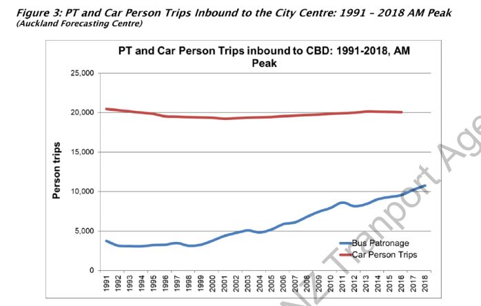
The Northern Busway has also been enormously successful in changing travel patterns. Prior to COVID, there were around 35,000 trips on busway services and most of those will have crossed the bridge, and most of those trips will be at peak times too. At the very least, its success has pushed back the need for a crossing by decades, which is hugely beneficial from an opportunity cost perspective.
If the media really wanted something scandalous to write about, perhaps they could have started with one of the responses to a question by Julie Anne Genter. In it, the agency admitted their capital budgets for the coming 3-year funding period are already mostly committed and on projects that won’t reduce carbon emissions.
“Whilst I think there is very strong intent in the GPS [around carbon reduction and sustainability], the reality is that the programme in the next 3 years is unlikely to significantly shift the bar on carbon in New Zealand”
That’s outrageous in the middle of a climate crisis and will only make it harder to meet our obligations.

 Processing...
The Herald loves this sort of story because it feeds into the strange internalised inferiority complex that afflicts a lot of it’s boomer readership. New Zealand is a prison, New Zealanders are useless, politicians are useless, no one plans for the obvious outcomes (more cars, more roads, more bridges) and generally it is all a bit hopeless so we might as well just cut rates and move to a heavily fortified gated community.
Wouldn’t be surprised if that whole exchange and subsequent media flurry was orchestrated by NZTA. You can tell from the video of the select committee what a hard on Brian Roche has for a road crossing.
Quick question regarding the northern busway to those more knowledgable – if it was converted to light rail terminating at, say, Aotea station would there be any increase in capacity or just a reduction in buses into the CBD?
There’s no reason to reduce buses, keep the bus capacity and add rail capacity.
The parts where the busway would be converted aren’t the places where the capacity is constructed.
^Constrained
Surely high capacity light rail going every 2 minutes would be a huge capacity increase, especially if the tunnel went from Aotea to University, the Hospital then Newmarket.
I haven’t used it but it sounds there are plenty of time savings to be made between the harbour bridge and any city destination, especially at peak time.
And surely any LRT/HRT that doesn’t convert the Busway would be even more expensive and largely just duplicate it?
The line would only need to connect to Aotea and connect with the new CRL that will go to all stations.
But it shouldn’t stop there. It should carry on to Newmarket and create stations under the University and Hospital, add new rapid transit stops, not just Dumping 90% of the passengers at Aoeta
Depends on what exact implementation you used. But yes, you could fairly easily have a system that had more capacity. Light rail might have up / around double the capacity of the busway depending on the signalling system and the length of the platforms. There’s a lot of variation in light rail systems around the world.
It’s also hard to fully nail down the maximum capacity of the busway, the performance would degrade slowly over time as capacity continues to increase, rather than be a kind of hard limit. I would hope a light rail north shore line would be able to take double what the busway does though.
The busiest single hour for people arriving at Wellington Railway station in September 2019 was 8,650.
If light rail from North Shore had only two lines going across the harbour and a dead end stop at Aotea centre I would be suprised if it could match Wellington. I would be interested to hear how it could from anyone who thinks it could.
Well, the current riderships is what, 8 million? That’s 22k a day, 11k each direction and that doesn’t account for differences between weekdays and weekends. So lets say at peak it’s already carrying 3k in it’s busiest hour?
Light rail should be able to double that easily using one line with long LRTs vehicles and 4 minute frequencies. No problem
It would depend on how the trains are managed at the Aotea end. If it is a simple two platform terminus such as at Manukau, then I think you would be right it would struggle to match Wellington.
To get a train running every 2 – 3 mins for some serious capacity then either through running or a complex set of tracks ‘behind’ the station that would allow trains to clear the platforms quickly is required.
Surely we couldn’t dump the entire North Shore line’s ridership onto Aotea to be distributed onto the CRL, we should be tunnelling through to Newmarket via Uni & Hospital etc
Hold on a moment. One of the reasons for CRL was the limitations of a dead end Britomart. Now are we saying a dead end single line light rail could have larger volumes than the current two line and five platform Britomart that is about 70 metres wide?
Why not? Current 2 platform 4 line Britomart is only getting a train every 3 minutes at peak. A North Shore line should be able to match that frequency from opening day so then its a question of vehicle capacity and we are still aren’t running a uniform 6 car timetable
Ignore 2 platform. The point is the Busway already carries more passengers than any single rail line, so you’d think the added capacity and shortened journey times should make ridership skyrocket
Asdf
Short answer, yes it is possible that a solid light rail system could handle that kind of capacity (20k passengers per hour) in a terminating station. It would be double tracked in, like Britomart is now, and would be 2 or 3 maybe really solid platforms.
There are two seperate constraints, the stations ability to handle that kind of boarding and disembarking, and the ability to turn that many trains around at terminating platforms.
The boarding and disembarking people capacity should be totally solvable in a 2 or 3 platform station. Plenty of exit points (instead of two for Britomart), seperate off platform walkways, wide platforms, and Spanish solution style platforms or both side disembarking / boarding would be able to handle that kind of capacity. To get people on or off trains, up into the streets, or other onto lines.
The turning trains around would be a solvable problem too, but it would be more difficult. Stratford station on the jubilee line in London is a terminating station that has 3 platforms and terminates and returns a max of 30 tph there (vs 24tph for final new signalling system CRL non terminating throughput). Overall line capacity is 26,000pphpd.
It’s amazing what you can do when you ditch mainline /heavy rail standards and get to make a signalling system and rolling stock from scratch, that isn’t compatible with every other track in the country. Switching can be much quicker, and headway’s much tighter.
However, this is all moot anyway I hope, whatever final form north shore system is chosen, it should be compatible with either a northwest line or the isthmus line, allowing at least some trains to through run. Provided we choose signalling systems and rolling stock that would be able to handle ~40,000pphpd under perfect, grade separated conditions. (Not that the other 2 lines would have to do that, just that their systems would be upgradeable to do that on a better corridor)
Tunneling to the uni and the hospital is very attractive, I think the northwest line should go through the CMJ stopping at mercury lane, east end of Grafton bridge, and the uni. Most of it could be elevated too, reducing costs.
the CRL is needed to add more capacity for the rest of the network that already exists. Instead of converging on a single line in and a single line out, they are converging on 2 lines in and two lines out. It is not to add more capacity to Britomart, although in doing so it will. We wouldn’t add more track south of Aotea in order to add more capacity for the line north of aotea. It would only be double tracked anyway north, instead of 4 lines converging on one station.
New Zealand really isn’t the place to look for inspiration for rail systems. Personally my favourite is Sydney metro. In the future with more rolling stock purchase, they would be able to run at 46000 pphpd. All on double track. https://en.m.wikipedia.org/wiki/Sydney_Metro. Admittedly one station wouldn’t have to handle all that terminating capacity. A few of those central city stations would most decidedly be able to handle more than Wellington central though.
The problem is there doesnt seem to be an obvious fit geographically for what you join to the North SHore line, at best we should dig through to Newmarket and then one day in 50 years we can attach it to an extension to Panmure & Botany or drill south towards the Airport. But it does seem a shame to have a lot of dead end lines coming into the City, as the NW & Dom Road lines are likely to be surface running light rail ending in Wynyard Quarter
Greater Auckland worked this out years ago. Join the north shore (Albany and Takapuna) to the northwest and the airport line. Run a train every three minutes from the north and the same from the south (every six minutes on each line x2)
Run 120m long trains like they have in seattle. 1,000 passengers each. 20,000 passengers an hour each way, 40,000 in total.
Yes it would have more capacity than the CRL. You get that with a purpose designed urban rail system, rather than a retrofitted legacy mainline system.
How do you link up with either of those lines, unless you don’t use the future proofed part of Aotea? Doesn’t seem an obvious way, unless the tunnel comes up at wynyard somewhere and then runs on the surface intl the CBD which seems like a waste
I’m interested in what you mean by future proofed part. Is only one end considered future proofed? I’ve looked around but I can’t seem to find anything about it online easily. I presume this would pertain to tunnelling under the cut and cover tunnels of crl. And weather they’ve been strengthened to be able to handle that. I was under the impression that the in the final form the tunnel would be up / under Wellesley street. Although the first stage might just connect to a surface queen street system.
Yeah supposedly by future proofed, it means that platforms for a North Shore line can be installed below the CRL platforms at Aotea at a perpendicular angle, but I have seen nothing elaborating on that
Not sure if this reply you did is in the right place Kraut but in anycase , yes as far as I know, it’s just a future proofed box or provision for one next to or under Aotea. Also a line perpendicular line under I can see in some design documents.
My thinking would be that this more fully underground “CRL2” is more of a far in future system though you never know. Initial Northshore lines more likely to be a light rail / metro system surface running as Riccardo says above (see this blog’s CFN2 here https://www.greaterauckland.org.nz/congestion-free-network-2/ ). Across the harbour could be bridge or tunnel depending on all sorts of things not least money constraints. I think bridge would work better initially so that a future tunnel is likely not to get in the way of any NS line tunnel. The initial surface level system could be virtually all grade separated in the northern end, apart from the Wynyard / Queen St sections.
Maybe it’s a good time to toll the bridge again to help manage demand and push viable trips to public transport. It boggles the mind that there are calls for billions in further capital investment before variable pricing for demand management has been implemented. Applies to the who road network, not just the bridge of course.
I tend to agree with Andrew.
Put tolls on the bridge but at the same time start the building of a Light Rail, and maybe an (electric) bus only road, tunnel to encourage the shift to PT.
Another option I’ve wondered about was to make all motorway off ramps that lead to CBD destinations T3, or at least T2.
Andrew, tolling the bridge does seem to make sense. If the toll was at the inflation adjusted level of the first toll, then in the seven or eight years that planning would take for light rail, funding would be in place to commence the construction of this project.
What about if the toll had been adjusted to remain the same %age of the average house price throughout…? :/
Well, that would throw a cat among the pigeons. It might reduce the popularity very slightly of the government and reserve banks’ ongoing efforts to pump property prices.
What was the last toll when it was scrapped and what does the equate to in today’s money
The initial toll was 2/6, worth $5.90 today. It was 25c when it was scrapped in 1984, worth $1.50 today. I submitted for a $6 toll on the Puhoi-to-Warkworth motorway; NZTA argued that anything over $2.40 would lead to too many people using the alternative free route. No decision yet.
All new motorways should be tolled, it is far easier to enact than more sweeping changes like systematic congestion charging.
Of course it should be tolled. Quite apart from the money that could be used to improve alternatives, in itself would reduce congestion.
Especially if set at whatever level shows a nice 10-20% switch to bus, ferry, active (when possible), wfh, timeshift, WRR, esp at peaks (there are so many alts already).
Too easy, of course, would entirely lose the tiny justification that remains for another road crossing.
All over there is no attempt to address congestion and all the other negative impacts of too much driving with demand management, only through the well known counterproductive tool of increasing road space. Surely the imperative of climate action will surely see our transport agencies and councils actually charged with traffic reduction through system management, not just road building?
You’d think so. But the transport sector is practised at this game. They fool CEO’s and they fool politicians.
For example, on Thursday in the select committee, WK’s CEO replied to JAG’s question about reducing carbon emissions being the major strategic factor over the next 5 – 10 years: “actually we have four key strategic factors, carbon and sustainability yes, but also obviously safety and other things in there as well… Whilst I think there is very strong intent in the GPS [around carbon and sustainability]… the reality is that the programme in the next 3 years is unlikely to significantly shift the bar on carbon in New Zealand.”
And her answer to JAG’s question about the overlap between reducing road deaths and carbon emissions was: “electric vehicles tend to be safer because they’re newer. In some places PT is safer. But not in all cases.” You’d have to be very poorly informed by your staff to pull that together as an answer.
And David Parker, Minister for the Environment, was duped into believing wider motorways can lower emissions: https://www.stuff.co.nz/environment/climate-news/122591305/sh1-upgrade-wider-motorway-can-lower-emissions–david-parker
It’s a beat up so they don’t have to build a cycleway across the bridge.
It really does feel like that. But isn’t Skypath so expensive because its engineered to attach to the central bridge piers not the clipons for the exact reasons of the structural integrity?
Quarter of a billion dollars for a footpath expensive?
This reminds me of when the Victoria park viaduct had “concrete cancer” and desperately needed replacing with a new six lane viaduct because it was about to fall down.
When they got the extra funding to build the tunnel alongside to get seven lanes instead, the concrete cancer went into a miraculous remission and was never heard from again.
In 2019 Phil Twyford announced a refreshed NZTA board. Surely they will be supporting of good analysis and doing the right thing. They will know the cost benefit ratios. The must be in tune with our labour governments priorities to intensify and increase the portion of there budget on PT. For NZ to compete with Sydney, San Francisco or Singapore we must reduce our high congestion costs and our high cost of oil and emissions. Getting it right and making our cities more user friendly is pro business. If the board is not in tune then it should be replaced again as $billions and our economy that depends so much on transport costs are at stake.
On a positive note in Mangere, Otahuhu and Papatoetoe, where I live I visit many houses in the area I notice that just about on every street the amount of new homes being built. 2,3 and 5 storey apartments. The area is looking good and there are many more coming.
Same in Mt Eden/Sandringham with many multi-home developments on the main arterials (Dominion Rd and Sandringham Rd) and I just heard of a 31 home development on up-Zoned land in Grange Rd, Mt Eden. Some large vacant blocks have been created in the last 6 months with future potential too.
There are some great developments in those areas. I saw a street in Mangere (I think) which was rows of new terraces on both sides.
“in the press release they talked how the mostly completed Western Ring was built to provide resiliency – though in the committee they then admitted it failed at that task. ”
Seems to me this is what happens when you add roading but don’t price the system. Does anyone have the wording used?
What about the bit where they said trucks won’t be able to use the outer lanes? And does that include double decker buses?
Seems like a good excuse for bus and heavy vehicle priority lanes up the middle and general vehicle traffic to stay on the outsides.
Its very narrow isn’t it?
Not *very* narrow, the centre lanes are still 3m wide while the limit for road vehicles is 2.5m wide.
Overweight vehicles are already required to use the centre lanes. They are suggesting that sometime in the next twenty years, other trucks might need to have some time or lane limitations.
“Any restrictions would be determined by the growth in additional heavy vehicle traffic using the bridge in the future. The current maintenance strategy and traffic demand assumes restrictions will be needed within the next 20 years.”
Mitigation could include limiting the lanes heavy vehicles can use, the number of heavy vehicles allowed on the bridge at any one time, or the time of day they are able to travel on the bridge.“
Apparently the double decker buses actually have higher axel loads and do more damage than most if not all trucks. Came as a surprise to me but actually means they’re doing all sorts of damage to the wider road network.
This is another reason why they should have gone with articulated buses in my view.
The busses have higher axle loads true and do much more damage to the road surfaces themselves. But that doesn’t necessarily mean in the bridges case they will be doing more damage to its structure. Compared to a truck or trailer of its size the double decker buses has fewer axles, point loading the surface more. However, they might be lighter per unit of surface area they take up on the road (they are pretty long), and therefore while damaging the deck / road more, don’t do as much damage to the underlying structure, because they don’t load it as much (because they would be lighter).
I dont have all the figures though, so its just speculation
The deck is very much the bridge. Your more basic bridges have a thick concrete deck slab sitting on the girders however I think the clip-ons have steel only 30mm or so under the AC, this is why the AC seems to get replaced every year. I guess this is where they would like to stick some more steel if they could.
I’ve never seen a cross section however so don’t really know what it looks like in detail.
yes long articulated buses called trains are very much what we should have got, and now must get on with.
When the focus was on building the north western busway they were looking at double articulated buses like I had advocated for the northern busway. They had done the various studies and were about the release consultation material and 3D visualizations and then the 2017 election happened and the promise for a $6Billion light rail line from unknown origin to unknown destination was made and so the idea was scrapped.
Articulated buses are better for boarding speed and axel weight (cos we won’t build bus heavy pavements properly, Lower Albert shows we can, but is the only place), but are problematic in city centre streets, especially in volume, they’re just harder to fit and turn, and keep users safe around on streets.
If only NW busway was begun when it was supposed to be, with the supersizing of SH16, Nzta dodged that then, and have ever since. Twyford announcing LR for that route simply gave them their latest excuse.
Instead of building a second harbour crossing, would it be better to building an improved first harbour crossing beside the existing and then demolish the existing? It would be much cheaper than a tunnel, wouldn’t need much change to the approaches, would include walking cycling and PT, could be a lot nicer looking, etc. Maybe they can fix all of the problems for cheaper than any form of tunnel.
Yes, but why demolish the existing?! Just keep it, you not only save the money of demolition but there’s an eight lane bridge you don’t need to rebuild.
Seems like a good plan to me except only demolish the clip on. Keep the original bridge for buses cycling walking. Railways are way too political and take way too long to build in an urban environment.
2nd harbour crossing? You sound like National’s transport MP 😉
We already have 2 crossings over the harbour.
If you visit the northern end of the bridge, you can see many recent core samples have been taken of the pylons. It is not just adding steel to the bridge that is a concern to NZTA.
Of course the bridge isn’t going to fall into the ocean, but the first step will be diverting heavy transport to the upper harbour crossing and busses to the center span. This is going to need road investments to upgrade the connections through Hobsonville and of course, Skypath/Northern Pathway will not be proceeding anytime soon.
Anyone can OIR the latest structural reports. If you are wondering why you cannot cycle the bridge, you should do so as there is some interesting reading.
As for alternatives. I would like to see a double decked tunnel dug. The first level should be rail and the second left as future proofing for a second rail track or road, whichever is then needed in the years to come.
“This is going to need road investments to upgrade the connections through Hobsonville”
It’s a good thing that we’ve spent the last 30 years almost continuously investing in this route and it is now a motorway. We could restrict heavy vehicles on the Harbour Bridge tomorrow if we wanted. The fact that we haven’t done this proves that the NZTA believe that the structural integrity of the bridge is fine.
I know its a motorway, but with all the additional heavy transport, it would need upgrading and more investments.
The sooner the Govt and Auckland start to spend big on transport (Rapid Rail, better PT and AWHC that includes road and rail), the sooner we can get the region moving again.
Money is cheap, borrow it now and start the build.
Interesting. How come Hobsonville would need upgrades? Its already a full motorway connection all the way through there is it not?
And are the structural reports you are talking about referring to the concrete piers (or whatever they are called) that the bridge is sitting on, or the steel bridge itself.
And would a sunken tube tunnel be a viable option? seems like a good avenue to go down for a more cost effective tunnel.
Building the second tunnel now might be more effective, but it would be a lot of cost having something sitting there not being used, but having to be maintained, plus the opportunity cost. I believe it would inevitably be put into service as a road tunnel. It would be better to do the cost benefit analysis based on that option. I really don’t know that it would hold up financially. Quad tracks to the north shore seem like a thing that would be needed in at least half a century, at which point it might be better to just do the tunneling then, choosing a better route, or other design feature we didn’t think of now.
I was speaking to an engineer who worked on one of the prior AWHC iterations – They said that the bridge out west wasn’t rated for the heavy trucks… Dunno how accurate that is, not their specialisation.
“But what they didn’t say in either situation was that the business case completed last year confirmed that the priority was to focus on public transport with a road crossing at the bottom of the list and not needed for decades, if at all.”
What I find when you read many of these business cases is that the client has normally already chosen what the answer is required to be and the business case is simply there to write a story about why it’s the answer. This is part of the issue with projects like these being decided through politics and the respective lobby groups.
For this particular one it seems they tried to discredit any road option by requiring the tunnel to be >5km in length when it actually only needs <3km. It also seemed to focus on creating traffic issues as opposed to addressing them.
Indeed, or for that matter a bridge of >2km. I wonder how many times they sent that business case back cos it didn’t give the answer they’d wanted.
If you look at this, at the Skypath, at the motorway to warkwoth, at their disastrous go at light rail turning it into a full metro… it seems NZTA are incapable of delivering fit for purpose plans. They supersize everything and add a digit to the cost.
All the PT tunnels investigated (from memory) seem to go all the way up to Akoranga too, to join the busway where it is bi-directional. I would have thought it would better, and easier to join stop the tunneling just north of the bridge, and re-jig the motorway to get enough room for a bi-directional light rail line (you’d get an Onewa station too). Seems like they’ve totally excluded your option of having the short tunnel, regardless of mode, perhaps there is some other reason that they don’t want to do that. Ground conditions, or site sizes etc.
They do it because they’re stuck to the idea of a combined motorway and rail tunnel. It’s the only way to make the motorway look reasonable.
It’s the opposite actually.
Two separate tunnels would be both cheaper and more flexible. They were forced into a combined tunnels from lobby groups such as this place making the likes of Len Brown and Phil Goff dictate that it was required to be a combined tunnel.
We haven’t advocated for a combined tunnel. If we do tunnels we think they should be separate. We also think they shouldn’t be tunnels but a PT and active only bridge.
The main push for a combined tunnel is actually coming from the road engineers at Waka Kotahi. The reason, all the analysis shows they should only build a PT crossing so the best chance for them to get a road crossing is if they can lump it in with the PT one.
Also from what we’ve heard from multiple sources and the business case. The writers were forced to include the road crossing by those WK engineers even though it couldn’t justified by any analysis. They just can’t stand to see their pet project they had hoped to be the centrepiece of their CV be ruled out
Matt L
That may very well be what you say today and its good to hear you reasoning has evolved, however having had this discussion with you many times over the past 15 years or so I know that for a long time you advocated for combined tunnels because there was a fear that if they were separate the rail tunnel would never get build.
I’m sure now that if we are only talking about a rail tunnel then you would be happy for there to be no road tunnel, however if the job was to build a road tunnel tomorrow you would be very much pushing for the rail to be combined with it.
I’m happy to be proven wrong, however I can’t think of a single engineer who would think combining the rail and the road tunnels as one is a good idea.
https://www.greaterauckland.org.nz/2013/10/24/more-bore-for-your-buck/ 2013
https://www.greaterauckland.org.nz/2013/01/28/north-shore-rail-and-the-harbour-crossing/ 2012
When is this mythical past in which Matt L advocated for combined tunnels?
Just more of Richard’s imaginings.
No need to get all salty because I have a longer memory than you. You may want to look further back to when people were campaigning for Len Brown and they were looking to designate the harbour crossing. The very cross section in that post you provided is the result of said campaign.
https://www.greaterauckland.org.nz/2009/07/04/next-harbour-crossing/ 2009
How much further back do you want me to go before you accept that your memory is wrong?
I think your memory is faulty and you just don’t want to admit you’re wrong.
It was only raised around the 2012/13 timeframe but we didn’t push it.
We’ve certainly evolved our thinking on many things but we’ve been consistent on that one
Matt L
Your post in 2013 was the result of Len Brown pushing for the combined tunnel as you and others had been campaigning for back in the 2005 to 2010 time frame. The 1st versions we saw people campgining for were the sunken box tunnels and the cross section in your post came about after waterview was upgraded to 3 lanes.
I recall having many debates on why I thought having the two separate tunnels were more ideal as it was not only cheaper but you could build each one as and when required.
As I noted before, the fear was that if they were separate they would only build the road tunnel and not the rail tunnel and hence the insistence that if the road tunnel was made the rail tunnel must also be made. The easiest way to force this to happen was by combining them.
This was also back in the days when the CRL was said to cost between $900 Million and $1.1 Billion and people were debating about it being 4 tracks rather than 2.
To be fair, it was more the people who chat in the forums and comments than you personally in your blog posts.
“lobby groups such as this place”
“Matt L
That may very well be what you say today and its good to hear you reasoning has evolved, however having had this discussion with you many times over the past 15 years or so I know that for a long time you advocated for combined tunnels because there was a fear that if they were separate the rail tunnel would never get build.”
“To be fair, it was more the people who chat in the forums and comments than you personally in your blog posts.”
Lol.
‘To be fair, it was more the people who chat in the forums and comments than you personally in your blog posts.’
So not a Greater Auckland policy then? Cool, lets move on.
Another crossing is needed even if it is only for rail. Without it we do run into problems because the buses that have been capping vehicle numbers on the bridge are HEAVY vehicles. It is not economically viable to divert heavy traffic via the WRR. The WRR is an alternative/backup but not a replacement option.
The clipons have a finite life (even after strengthening, while the main bridge is ok).
So realistically there are 2 options:
1) Build a rail tunnel/bridge in the next decade and pedestrians/cyclists if a bridge).
2) Build a rail+road tunnel/bridge (3 traffic lanes each way) then relegating the clipons to pedestrians/cyclists.
The only other option is to build a complete replacement (bridge realistically) but that would be too expensive and not provide the resiliency of the other 2 options.
The advantage of option 2) is that it doesn’t induce traffic while providing resiliency. Option 1) does provide some resiliency but not for trucks, buses and other work type vehicles.
I will also add that part of the reason why I think Skypath has been so delayed is that the thinking might be build a bridge and incorporate it into that…. or tunnel but use the existing clipons for pedestrians/cyclists. Save $300m by not building it separately perhaps.
Let’s not forget the objectives of the western ring route. From the Waterview Connection part of it, for example:
“One of the objectives of the WRR is to relieve congestion that currently occurs on SH1 and to provide an alternative rute north across the Auckland Isthmus. The provision of the Waterview Connection is expected to result in traffic diverting from SH1 and CMJ to the WRR. The modelling has indicated that there will be a shift in longer distance trips from Sh1 to SH20 (WRR), consistent with the objectives of the WRR”
And let’s not forget, too, the shonky modelling used. For example, for the Waterview Connection part of the WRR, they assumed fully ZERO increase in the number of truck trips in Auckland would result from the Waterview Connection. https://i.imgur.com/O87mi5V.png
I haven’t bothered to look at the modelling for the rest of the WRR, but I have been advised in an OIA response that the same assumption – no changes in the total number of “person trips” – was standard practice, and WK knew of no projects in NZ that didn’t include this assumption.
What this means is that we’ve built roads for the trucks on the basis that this would free up the rest of the network, eg the WRR would free up space on the bridge, when in fact professional engineers keeping abreast of the international evidence – as their code of ethics requires – would know that this only materialises if we also reduce road capacity at the same time to prevent newly induced trips.
On the bridge, the way to provide the required reduction in road capacity to match the provision of the WRR was the reallocation to bus lanes and to cycling and walking lanes.
It’s not too late, and if WK actually intended to reduce congestion in the network to improve travel times for courier drivers and tradespeople, etc, and if they actually intended to reduce transport emissions while improving outcomes in health and access, they would do some quick reallocation this week while traffic volumes are low.
Yes, they should be doing it this week, just as they should’ve done it during last year’s lockdown.
The modeshift we’ve seen hasn’t been due to Covid.
It has been due to a lack of resilience in the sector – an inability to see the opportunities in front of them.
“And let’s not forget, too, the shonky modelling used. For example, for the Waterview Connection part of the WRR, they assumed fully ZERO increase in the number of truck trips in Auckland would result from the Waterview Connection.”
Where did you pull that table from? From when I worked on this project they were expecting freight volumes to increase significantly on the WRR seeing as it was one of the main reasons for the route.
The G25 traffic modelling report for the Waterview Connection part.
Of course the WRR section will show an increase in truck movements there, it’ll have sucked them out of the other routes. The table I showed is city-wide, not just for the Waterview Connection. The modelling for other sections of the WRR will show something similar – huge increases in traffic including HCV’s on the new infrastructure, with a commensurate drop on other roads – eg arterials and SH1.
Keeping person trips the same is a technique that has been debunked and also shown to have biased road investment decisions substantially. It was still being used when the whole route was modelled. This may have changed now; I keep hoping it has, and would like to find out.
Heidi
Just reading that report and I found the following:
“The models estimate that some 6,000 vpd of the 82,400vpd using the Waterview Connection are due to induced traffic.”
“The ART3 model retains the total number of persontrips when different transport options are tested, but the amount of car trips changes. These additional car trips are not included as ‘new’ trips, because they will just be person trips changing the place, time, mode or route of their trip. It is estimated that about 93% of the trips on the SH20 Waterview Connection are due to rerouting, and 7% are due to ‘induced’ trips (redistributed, mode change, time change)”
So this statement of ours is correct if you are referring to “person” trips, but incorrect if you are referring to “car or truck” trips.
“They assumed fully ZERO increase in the number of truck trips in Auckland would result from the Waterview Connection
The paragraph you link isn’t about cars vs trucks. It’s about cars vs other modes. It’s an explanation of the types of induced traffic they do include, and the types they don’t include. I went into this in my post, https://www.greaterauckland.org.nz/2019/04/15/aladdin-and-the-magic-modeshift/
As an aside, the truck modelling was quite funny. The report says, when finding a 129% increase in heavy truck traffic between 2006 and 2026:
“This level of growth was considered to be too high, and possibly due to double counting of growth related directly to employment and additive growth factor related to Gross Domestic Product (GDP) growth. Following discussions with the peer reviewers the future growth was taken as 45% of that forecast by ART3. This value
was chosen to be slightly greater than the employment growth of 40% between 2006 and 2026.
“The 45% was chosen to include 40% employment related growth, but only a small additional growth due to GDP related growth. This approach reduced the potential double-counting of growth and brought the proportion of HCV traffic back to expected levels.”
These “revised” estimates for HCV traffic levels are given in Table 5.5. They are then applied to BOTH the Do Min and the Project scenarios, as is apparent in the table I’ve already linked, Table 6.20, which uses these same figures for both the Do Min and the Project.
They are, in 2026:
In the morning peak, 36,598 HCV trips
In the interpeak, 39,937 HCV trips
In the evening peak, 29,952 HCV trips
Note the models are fine to use for figuring out where the traffic is likely to be in the network, once strategic decisions about investment have already been made. It’s the use of them inappropriately as a way of working out the difference in vkt and travel times between the project and the do minimum scenarios that is at fault, and that has led to our transport dysfunction.
I suspecting the modelling of induced freight demand in a city is rather tricky.
You can expect things like expressways between cities to divert freight from rail to road, however within a city freight movers seldom have many other options unlike the majority of road users. Like if you are going to deliver some building materials to a house, what other options do you have?
The induced demand I can see happen is from reduced congestion. If we are moving freight from the ports for example, you could get 5 loads done per truck if the road is empty, or 2 loads per truck if the roads congested. As the freight needs to move however this may mean they simply have more trucks carrying less loads creating even more congestion.
I’m not a freight model however so I can only guess here.
Yes, just as buses can achieve more trips per driver and bus if they get priority lanes, trucks and vans can achieve more freight movement if the congestion levels are lower. In Auckland, this would be considerable.
Hence my comment above, “It’s not too late, and if WK actually intended to reduce congestion in the network to improve travel times for courier drivers and tradespeople, etc, and if they actually intended to reduce transport emissions while improving outcomes in health and access, they would do some quick reallocation this week while traffic volumes are low.”
Reducing road capacity (for example, via lane reallocation on the bridge) would increase local congestion initially, leading to lower network-wide congestion over time.
This would have multiple economic and safety benefits. Pricing can assist the process, removing much of the initial local congestion while locking in the lower longer term network-wide congestion.
And providing the other modes (the enhanced bus priority and the cycling and walking networks) needs to be done to provide transport options, as the only equitable way to add the pricing.
Hey Richard your expert memory is super cool and that, but a even a little bit of evidence for all your claims would, you know, make them a little more credible…
Urbanista
Why do people feel the need to be so abusive when I make a comment about something that is so obvious? It seems that if I said the sky is blue I would get abused and accused of making “outrageous claims” or “trolling”.
It’s a rather hostile response to me simply asking a question.
Richard, tone policing is, as ever, just a way to avoid the question. You are trying to hide behind taking offence, it doesn’t work. My post was not abusive, anyway, even if it was, you could deflate it by simply bringing evidence to back up your claims.
You never do, and in the face of others providing links etc that contradict your super male highway dood memory you still just bluster.
Is being evidence averse a necessary to be a highway guy, highways that induce ever more traffic that studies show that cause so much harm to people, society, and the planet? I guess it is.
Feel free to be offended by this post.
Wow, more abuse.
Not too sure why you feel the need to bring gender into this or call me a “highway guy”. It just screams hate and intolerance of others to me.
So what you’re telling me is that you don’t believe the traffic models for the Waterview Connection showed it would increase freight volumes on SH16/20 and you need me to dig up some evidence even though the entire point of my post was to simply ask Heidi where the screen shot of a mystery table came from?
I’ll note that Heidi was able to respond and agree with me without being hateful or abusive.
Urbanista
Would you insist on evidence if I made these claims
“The main push for a combined tunnel is actually coming from the road engineers at Waka Kotahi.”
“The reason, all the analysis shows they should only build a PT crossing so the best chance for them to get a road crossing is if they can lump it in with the PT one.”
“Also from what we’ve heard from multiple sources and the business case. The writers were forced to include the road crossing by those WK engineers even though it couldn’t justified by any analysis.”
“They just can’t stand to see their pet project they had hoped to be the centrepiece of their CV be ruled out”
I ask you for evidence for your claims.
Shouting: ‘look over there’ at someone else, is not an answer.
Urbanista
If you are under the impression that traffic model predicted zero increase in traffic on SH16/20 you may want to refer to the following report.
https://www.nzta.govt.nz/assets/projects/completing-wrr/docs/docs-enquiry/application/g25-traffic-modelling-report.pdf
If you refer to Table 6.1 and compare DM (Do minimum) with OPT (Option) you will see increases of between 9 and 20%
So do you want evidence for those quotes I provided?
No one is under that impression, stop strawmanning everyone and go troll somehwere else.
Sailor Boy
If nobody is under that impression, why is me stating that we expected the traffic volumes to increase as part of Waterview causing people so much anger and claims that it’s “nonsense”?
It’s probably the bit where you deliberately conflate traffic volumes on SH16 and SH20 with total traffic. The bit where you deliberately spout nonsense to cause anger makes people angry that you are spouting nonsense.
Sailor Boy
Have you actully tried reading anything, including what you write yourself?
Heidi provided a link to a picture saying “they assumed fully ZERO increase in the number of truck trips in Auckland would result from the Waterview Connection”
I simply asked where the image was from and that “when I worked on this project they were expecting freight volumes to increase significantly on the WRR ”
This caused Urbanista to get all abusive, KLK to claim it was nonsense and now your getting abusive making claims that my post was a “deliberately spout nonsense to cause anger”
It seems some people, like yourself, are just so full of anger that they a blinded by hate and will just abuse me for anything. Classic example being when you an others abused by because I said I like the native bush in the CMJ, and now today because I suggested a motorway project would increase traffic volumes.
“KLK to claim it was nonsense”
To be clear, I made this statement about most of your posts, not specifically this one.
And of repeatedly claiming abuse in the face of challenges to this nonsense? Lots of new examples since I posted it. Goody.
KLK
Yes I see you make that statement multiple times.
I make a post saying a motorway project was expected to increase traffic I get sexist abuse, which you claim is “calling out nonsense”
I make a post saying I like the native bush in the CMJ, I get abuse for that and you claim is “calling out nonsense”
I make a post saying that installing speed bumps at 100m intervals down residential roads increases fuel consumption, I get abuse and you claim its “calling out nonsense”
Sailor Boy provides a link to a document about induced demand which I was jsut getting abused for saying it was a thing yet you called it “nonsense” and apparently you “rest your case”
> Where did you pull that table from
Googled it, first result:
Beca’s July 2010 NZTA RONS WRR Traffic Modelling Report 2010
Page 62 (p67 in the PDF version)
https://www.nzta.govt.nz/assets/projects/completing-wrr/docs/docs-enquiry/application/g25-traffic-modelling-report.pdf
How did you google it? Did you copy the image into google image search?
Standard trolling.
Talk nonsense, get called out, claim abuse.
lol, “nonsense” like people thinking the Waterview Connection would increase traffic?
Note: Ignoring what people say and simply abusing them is trolling. And belittling someone because of their gender is hate speech.
Asking for where a screenshot came from isn’t trolling.
https://www.vtpi.org/gentraf.pdf#:~:text=Traffic%20grows%20when%20roads%20are%20uncongested%2C%20but%20the,additional%20peak-period%20vehicle%20travel%20is%20called%20generated%20traffic.
You’d better the the Victoria Transport Policy Institute that all of their research is nonsense.
Why are you provding a link to a document that has almost nothing to say with anything I have said?
It would seem your comment is better directed at KLK who claimed it was “nonsense”.
I rest my case.
My view, based on a lot of past reports, blog posts and comments, is they should:
1. Ban trucks (heavy only?) from the clip-on’s 24/7 ASAP.
2. Allow buses to use them but encourage ones that are bypassing the city to not use them.
2. Toll all vehicles except buses from say 6am to 7-8pm. More charge for trucks.
3. Continue planning/building the Northern Pathway.
4. While this all happening and plan/build an additional PT & probably active mode crossing:
I suspect the best type and most likely the most affordable/fastest version of this would be a bridge for light rail/metro. Connecting to Wynyard and would physically then be connected to a Queen St, Isthmus etc line(s) as well.
Ideally connect to a potential Onewa Rd PT interchange otherwise to Akoranga and continue replacing the busway north.
5. A lot more into the future if a lot more capacity is needed, a rail tunnel could be built across harbour connecting beside HR Aotea Station. This wouldn’t be physically connected to the Aotea line as is already future planned but could be automated HR or Metro system that continues to perhaps Takapuna. Crosstown tunnels/lines to the city Universities, Hospital, Newmarket. This would all be ascertained at the time of course but by then the demand for travel to these places may require something substantial anyway. All underground or fully grade separated. Beyond that it could connect to Panmure say (HR & Eastern Busway connections). By now we would likely want LRT going to all major points around the city, and before this I’m sure a North Western LRT or whatever line would be built too.
There is no way the Northern pathway should continue. What sort of madness would it be to spend 300 million attaching a cycle/ped path to a knackered bridge?
We need to build another bridge or tunnel and then use one of the clip ons for cycling/peds.
I am not even sure the clip ons are safe for HT from a wind perspective. If a big truck can be blown onto two wheels and hit the center spar, imagine if a double decker bus was blown onto two wheels on the other lane of the clip on? It could tip right over the side. https://www.youtube.com/watch?v=xDvQ2xUVzoY
And in the meantime, what should be done to get cycling and walking over the bridge, Lewis?
“ There is no way the Northern pathway should continue. What sort of madness would it be to spend 300 million attaching a cycle/ped path to a knackered bridge?”
It’s planned to be attached directly to the strong as piers. (Is that the right word? Supports that are in the water holding it up. Which are said to not have an indefinite life left in them.
Just wondering: what effect on capacity would a policy have if NZTA said “only heavy vehicles in the centre lanes (ie buses and trucks ONLY) and only cars on the Clip-ons”? That would seem to be (to me) what they are implying regarding loading. Effectively gives just two car-only lanes each way. Would Auckland still work or grind to a halt?
Also, re the centre lanes: would you have one bus lane and one truck lane each way, or would you have combined bus/truck lanes? If they are only 3m wide that would be a little bit hairy at 80km – presumably they would need to be reduced in speed to max 50km to allow for all the larger vehicles using the narrower widths.
They already do this more or less. Over weight vehicles are already banned from the clip ons, with an exception for double decker buses buses. The so called High Productivity Vehicles (aka super heavy trucks) are banned from the bridge entirely.
There isn’t really that much of a problem with not having heavy vehicles (other than buses) on the clip ons, because the clip on lanes lead to/from Ponsonby and Fanashawe Street where there aren’t many trucks going anyway. The centre lanes are the ones that link with the motorway south, west, and to the port, which is where they trucks want to be anyway.
If the clip on’s are getting old a couple of options
1) use one clip on for skypath and 1 car lane
2) rebuild 1 or both clip ons to take rail as well, where the clip on/ons are self supporting
I also think the buses, especially the double decker’s should be banned from the most edge lane as any crash (or high wind) could cause a roll over, falling off the bridge into the sea and loss of 50 plus lives
How many times has this happened Bruce? To any vehicle on the bridge?