It seems now every year at this time Auckland Transport rush out a heap of consultations before everyone heads off for summer holidays – we saw this in 2018 and in 2019. Some of these we’ve already talked about in posts recently but there are so many so here’s a summary of the key ones.
Mission Bay town centre – closes 3 December
We covered this last week with a post from our friends at Bike Auckland
Ash and Rata St safety improvements – closes 6 December
We’ve also kind of covered this one in this post.
Ponsonby Rd – Streets for People – closes 6 December
This is one of Auckland’s Innovating Streets projects and is really AT asking for idea – so it’s important people submit so it doesn’t just become a bunch of retailers demanding more/unchanged parking.
Changes could include things like extra space for on street dining, safer crossing opportunities, bike routes, and more space for play. These could be created with street furniture, artwork, planters and more.
Part of the feedback is just to find out which part of Ponsonby Rd they should be working on, with them saying
The project area has not yet been defined – but with a limited budget, we will have to focus on a specific area or areas along Ponsonby Road.
They also say
You can also express an interest in joining our community co-design group by leaving your details.
This co-design group will bring a diverse group of around 20 members of the community together to look at feedback from with wider public and further develop ideas.
Time commitment would be 3 x 3 hour sessions during three separate weeknights in late November-Mid December this year.

Ponsonby Rd should be one of our best urban streets but it is currently dominated by cars and it really needs to change so put some feedback in to help that process.
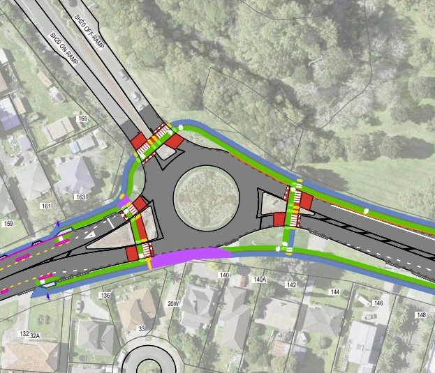
Blockhouse Bay Roundabout – closes 11 December
AT are looking to make the Blockhouse Bay roundabout safer but it seems like so many of their safety projects, their idea of a safety is to just slap down a couple of speed tables, which is better than nothing but doesn’t improve safety for everyone, despite them claiming so.
The proposed improvements, supported by the Regional Fuel Tax, aim to create a safer environment for drivers making turns, along with people walking, cycling and on motorbikes.
AT is now seeking feedback from the wider public and key stakeholders – such as local businesses – on the plans.
The busy area sees close to an average of 30,000 vehicles daily through the roundabout.
The proposed changes aim to improve safety for everyone by encouraging drivers to lower their speed on the approach to the roundabout to help them make safer turns.
The changes would also encourage the use of active modes in the area by providing safe places to cross the road.
The plans being consulted on would reshape the centre island, install raised traffic islands and paint new road markings to help guide drivers as they turn.
…..
Randhir Karma, Auckland Transport’s Group Manager of Network Management, says safety is a priority for Auckland Transport. $800,000 has been approved so far for this proposal.
“We are pleased to be working with the Whau Local Board to improve safety for people walking in this busy town centre through the Community Safety Fund.
“AT embraces Vision Zero principles which puts safety at the heart of everything we do, and where the road network is safe for all users. No deaths or serious injuries on the transport network are acceptable.”
Here’s the proposal.

If this is “encouraging active modes” that’s a quite an indictment of how bad AT is at the moment. There are still pedestrian crossings way back from the roundabout, in most cases these are existing crossings but now just raised. And of course there’s clearly no support for anyone on a bike. Anyone wanting to ride to the shop better be prepared to risk their life of than two lane roundabout that almost identical to what it is today. In reality this is the design you get when your first priority isn’t safety but moving vehicles.
Devonport Parking Charges – closes 13 December
AT are finally looking to introduce paid parking at the Devonport Ferry Terminal – something they should have done long before their subsidised taxi trial. They’re also looking at other changes to parking in the wider village.
On-street parking around Devonport village and Ferry Terminal is in high demand, which means that people are often unable to find a park and become frustrated.
We are proposing changes to improve parking availability through Devonport village and around the Devonport Ferry Terminal.
Through Devonport village, we are proposing replacing all the existing parking restrictions to P120 time restrictions. This will keep parking restrictions more consistent through the village and be better suited to visitors. Around Devonport Ferry Terminal, we are proposing paid parking at 50c per hour on part of Queens Parade and the Queens Parade carpark.
We are also proposing 3 new P5 loading zones to improve parking availability for those visiting or delivering goods to local businesses.
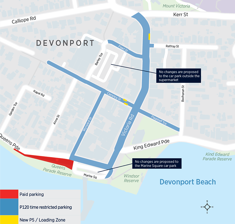
At 50c an hour it’s hardly a huge cost but it’s a start and presumably would be governed by AT’s parking policy which could be adjusted in future based on demand – getting it in place first is often the hardest part.
Mangere Cycling Improvements – closes 13 December
This is possibly the most exciting of the proposals here. AT are proposing a raft of safe cycleways in Mangere as part of the Southwest Gateway project (which also includes projects such as the Puhinui Interchange).
The Māngere Cycling Improvements project consists of five new designs/upgrades. The proposals combine with the existing walking and cycling facilities to create safe links for people travelling between Māngere Bridge, Māngere, Auckland Airport and the Airport Oaks employment areas.
The proposed improvements also provide wider connections to Onehunga, once the upgraded Māngere Bridge is complete in 2022.

There are more details on the website about exactly what is proposed and it seems to include a number of pedestrian improvements which is great. It’s particularly pleasing to see crossings being added to existing intersections where they’re missing, including roundabouts. And is this the closest we’ve got to a dutch style roundabout in Auckland?
I also like that they’ve got Councillor Alf Filipaina and members of the Local Board in support, as well as excellent local bike champ Teau Aiturau.
Onewa Rd Clearway – closes 13 December
AT are considering extending the clearway hours on Onewa Rd in response to local requests. Onewa Rd is also one of the busiest bus corridors in Auckland.
Recent local feedback, including a petition from Northcote’s former local MP Dan Bidois has asked us to investigate some clearway options along Onewa Road.
The proposal aims to improve traffic flow outside of peak hours by removing parking on Onewa Road, by extending the clearway hours.
We have assessed the advantages of extending the clearway hours and have determined that it will offer little benefit to commuters at the expense of parking. However, given the strong support through the local MP petition, we are happy to consider it. We would first like to know your thoughts on this before considering any changes.
We are asking feedback on whether we keep clearway hours the same, extend the clearway to no parking at all times, extend the clearway to cover 7am to 7pm on weekdays, or extend the clearway to cover 7am to 7pm everyday.
With each option, the T3 lanes would remain unaffected with no change to operational hours.
It’s weird that AT seem so reluctant to take away parking even when locals are asking for it.
The four options we would like your feedback on are:
- Option 1) Maintain the current parking arrangement on Onewa Road
- Parking would still be available outside of peak hours when the T3 lanes aren’t operational.
- Option 2) Extend the Onewa Road clearway to all hours
- No vehicles would be able to park on Onewa Road at any time.
- Option 3) Extend the clearway hours to run from 7am to 7pm on weekdays.
- Vehicles would no longer be able to park on Onewa Road unless it’s after hours or during weekends.
- Option 4) Extend the clearway hours to run from 7am to 7pm everyday
- Vehicles would no longer be able to park on Onewa Road unless it is after hours.
This is the stretch of road they’re looking at.
![]()
How about doing option two and making that freed up lane a permanent bus while they’re at it as at this point, AT should be doing everything they can to push mode shift.
Speed Limit changes in West and North – closes 17 January
Following on from the speed limit changes last year, AT are proposing to change speed limits on 26 rural roads in the west and north. Details and maps of the roads they propose to change are on the link and they say if approved, will come into effect on 31 May 2021.
These should all keep you busy for a while.

 Processing...
Thinking about the traffic island at Blockhouse Bay and improving the safety for people to cross the roads.
While is would be expensive, I have wondered what the outcomes would be if rather than a series of “close your eyes and run to the centre Island” type of crossing, they were to build a series of underpasses from each of the connecting roads to a central lowered point under the traffic island.
These could be Both a set of stairs and a long gradual ramp.
I would venture to suggest this would keep the petrol heads happy as they wouldn’t need to “worry” about pedestrians crossing in front of them, and would improve the safety for pedestrians be keeping them well separated from traffic.
Far better, have the ramps and underground roundabout for the cars and preserve the open air & daylight for people.
The proposal’s for Blockhouse Bay Rd (BBR) and Royal Oak (RO) round-a-bouts are remarkably similar and stupid and do not address the fundamental causes of Roundabout congestion.
Causes: 1) Pedestrian crossings. They are too close to the roundabouts and dangerous to pedestrians. They need to be at least 100meteres (Preferably 200) back from the round-a-bouts. Better still a bridge over the main roads or under ground pedestrian tunnels. The idea of raising does not improve pedestrian safety but does cause an obstacle that adds to traffic congestion.
2) Cars making right turns across traffic to enter drive ways and side streets (Especially noticeable at RO). Solution: a median barrier for at least 200 meters from the round-a-outs. Their are a number of options for this barrier that would fit.
3) Poorly design entry/exit ways on commercial premises close to the round-a-bouts. These need blocking off and redesigning.
4) Vehicles parking close to round-a-bouts. Especially troublesome at RO.
Parking off road is the solution. There seem to be plenty of options at both locations for this.
5) Traffic lights are an option that needs to be considered especially at rush hour.
6) Bus stops to close to the round-a-bouts. they should be well back from the round about and the footpaths indented so that a bus at a stop does not block traffic.
The tinkering by appointed officials seems to be simply an excuse for consultants to print money as nothing ever really improves. The suggested ideas by these people show a complete lack of knowledge about the problems of these locations and preponderance of theory over reality.
The solution is to reduce the roundabout to a 4-way intersection with traffic lights. Anything else is just polishing a turd (or potentially making it worse).
I suspect that most of the bureaucrats and engineers involved in these processes know that. But the proper solution is probably ten times what their budget is so they keep making these minor changes so it seems like they’re doing something.
Agree that is the solution. Maybe if they didn’t waste all their safety budget making St Helliers look more pretty then they would have enough?
Why is it so expensive? Don’t you just drive a digger through the middle and then put some asphalt down and some traffic lights?
Changing from a roundabout to a signalised intersection involves reconfiguring the stormwater system (both because of realigning the kerb and channel and because of changing the camber of the road). So all the buried services in the intersection need to be located and protected while digging up the existing stormwater pipes and laying new ones and laying ducts for the traffic light cables. That’s the time consuming, disruptive and expensive part.
Once the underground stuff is done then building new kerb and channel, laying asphalt, linemarking and installing traffic lights is relatively quick.
If the intersection needs to be kept open to traffic then all this is even harder and takes a lot longer because only a small section can be worked on at a time. The best approach is probably to close the whole intersection for a long weekend and work continuously to get it done (this isn’t necessarily cheaper but it will be less disruptive).
I guess it is expensive as you would need to divert Heaphy Street.
I would just signalise the whole thing as a five leg intersection and accept there will be massive delays. There is no place for multi-lane roundabouts in any town centre.
Then if the delays prove to be too much for people it will justify a diversion.
Just give Heaphy Street a very short phase. Maybe consider closing off traffic from Kay Drive to prevent rat runners, then Heaphy is essentially a cul-de-sac.
So the problem with these roundabouts isn’t the amount of through traffic in these town centres, it’s people wanting to cross the street, catch a bus or drive their car into their driveway?
Move the pedestrian crossings closer to all legs of the round-about at both Royal Oak and Blockhouse Bay. Have bus lanes on the approaches to the roundabouts – then have a reverse merge (bus priority) into a single lane approach at all legs of the roundabouts.
30kmh speed limits for the ‘town centre’.
Unfortunately none will happen, either because ‘that will affect flow or intersection capacity’ (what’s the project – safety or traffic engineering?).
Pedestrian crossings set back 200m backroom a roundabout. WTF. Turning a mere cross two streets task for a pedestrian to get to the opposite corner of typical intersection to a 800m hike. Yo don’t work for AT do you?
You’ve missed the biggest cause of roundabout congestion, too many people trying to drive through the same place at the same time.
Having pedestrian crossings next to a roundabout isn’t dangerous by default it depends on how the roundabout is designed.
AT should be removing all busy small roundabouts, they just don’t work for anyone. Why is removing a roundabout and replacing with traffic lights (the obvious solution) not being considered? Same with Royal Oak, Avondale, Denbigh / Dominion, Richardson / Dominion, etc.
I totally agree. I think in the Blockhouse Bay case the tree in the centre is a protected tree but the others have no such excuse.
Tree looks like a pohutukawa, maybe 30 years old.
I prefer roundabouts.
Perhaps the straight through traffic direction could have an underpass to take the load off, and essentially take cars out of the town centre
Why do you prefer roundabouts? They only seem to work during off peak. During lopsided peak traffic they just don’t work and the throughput is pretty bad too due to everyone having to almost stop and less lanes possible.
I have had to turn right from Blockhouse Bay shops several times at peak, because there is an endless queue from the right you just have to wait forever or take the slightest gap. I can’t imagine trying to do it on a bike.
They are terrible for bikes. Its almost impossible to cycle cross town via Royal Oak due to the stupid roundabout, I tried cycling through it once and it was as scary as it looks. And they aren’t that good for buses either, especially the tiny ones.
Cost?
I imagine the cost per life saved over the long term would be quite low.
@JJ, which of course would be nice if NZ didn’t go overboard with traffic lights. Many other countries have a single or 2 overhead light positions and a single light for each approach. In NZ we pretty much have overheads for each approach plus another 2 sets of lights for each and then often separate pedestrian lights too! Then there’s the ridiculous cost of both purchasing and installing them along with ongoing costs.
Costs millions to replace a busy roundabout.
The speed changes in the West and North were consulted on last year with widespread support, including from the local Boards. Unfortunately they were incorrectly notified due to an administration error. Council has decided to go back to consult again and then apply the speed changes next year. Lets hope that no errors occur this time and the changes are approved.
What a stupid system. Sure if they are increasing speed limits there should be consultations and notifications. But safety related decreases should be at the whim of the council. What is the worst case scenario; people have to slow down for a bit and if it isn’t popular they vote out the council?
They don’t have wide spread support. They’re pretty unpopular in fact.
I suppose that depends which ones you’re referring to Bill. The changes proposed for the Tawaharanui peninsula (the ones that directly affect me) are widely supported.
The issue with Devonport parking is that people park there and go off for the day or overnight to places like Waiheke by ferry. P120 would certainly free up spaces for other users (who should mostly be walking/riding bus etc) but make it more difficult for those island users often with luggage…
If you need to store your car on prime waterfront land to go away for a day or overnight trip to an island then it’s a cost you should be building into your trip.
I haven’t had much luck parking my car for free at the airport.
At 50c/hour (8am-6pm only) it would still be cheap to park there for a weekend trip to Waiheke. Even a full weekend parked there from 6pm Friday night to 7pm Sunday night would cost you only $10.
Comparing to the rate at AT Downtown carpark, their Friday arvo to Sunday night ‘Waiheke special’ is $22
The idea is that it reduces people driving into the city to then go to places like Waiheke… Plenty of parking there (prime land or not) but it is taken up by commuters to the city that really should be walking/cycling/busing to the ferry.
If they can walk or Bus around Waiheke why-o-why can’t they do the same at the start of the journey , or is it they don’t have electric buses their side ? .
People going to Waiheke for the weekend must make up a tiny proportion of overall traffic. Whether they clog up the CBD or Lake Rd is largely irrelevant.
I remember 10+ years ago that parking lot had no time limit at all (see Google StreetView 2008 photos). I knew people living on Waiheke who left their city-side cars in that parking lot for days, weeks between their visits to the big smoke. Probably the exact behaviour that led to the 24hr time limit.
Platform 3 at Otahuhu train station will be opened this weekend.
The platform is just an easy walk through from the bus stop and I hope the distant platform 1 will be not used any more.
This should have been the plan when the large expensive structure was opened 2 or 3 years ago.
New roof has been added to platform 3 and now there is over 450 m of wide covered platforms and an extra 100 m of walkways and steps.
Early this year AT reported that thay were readying platform 3 for use when the CRL is opened in 2024. I am happy they changed their mind as the station will be much more user friendly.
I would really like to know how the spots to be improved are chosen. As far as I know, there is no map prioritising the barriers to walking or cycling. Also, a single spot could be priority for one but not the other. It raises many questions on where the money gets spent.
Onewa Road : Option 4). or as locals call it, the 7-7-7 option will probably get the strongest backing as its the best by a suburban mile.
I agree that Ponsonby Road has too many cars but there is no obvious detour around it. There was once (like 50 years ago in the 1970 District Scheme) a proposed western detour around Ponsonby by directly connecting Jervois and Richmond Roads (involving a bridge linking Wharf Road and Parawai Street) but I have seen nothing comparable since it was dropped in the mid-70s. I was chair of the Community Board in 2004-2007 when we put in a clutch of pedestrian refuges and successfully championed the 40kph speed limit that was implemented in 2008. But despite these safety improvements the real problem remains the sheer volume of traffic. The problem is that the grain of the local streets on either side of the Ponsonby Road ridge runs at roughly right angles to the north-south desire line between Herne Bay/St. Marys Bay and suburbs to the south so the road along the ridge is and always will be only obvious connecting road. There were hopes that the direct motorway connection of the Harbour Bridge with SH16 (NW motorway) would take some pressure off the Ponsonby Road route, and it has but only to a very limited degree and meantime the volume of local traffic has grown so the total number of cars now is greater than ever. Not sure of the ultimate solution but you cannot simply wish the traffic in Ponsonby Road away.
Yes you can, remove street parking for a bike lane each side, one lane traffic each way, and then a bus lane each way – perhaps in future is a light rail/tram type route from CBD, k road then all the way out to pt chev and back down Gret north road. And ensure that all neighbouring suburbs have traffic calming, so start making some of those streets one way, block off some, bollards, etc.
Narrows the street traffic, improves active modes, more space for walking, dining, etc.
As well as too many cars Ponsonby Road has far too many pedestrians for the absolutely sub minimal space allocated to them. Even a significant portion of this footpath space is given over for for signals and signage for those cars. The worst thing is, the 5m of that precious corridor given over to cars doing absolutely nothing, just being stored there.
It’s called traffic evaporation. No kidding. You can wish these cars away. Journeys will be made by other modes, local business will spring up requiring less distance to travel to get groceries etc. there’s this double standard in people’s minds, that people walking bussing and cycling aren’t making important trips but car users are. Which means we can’t take from cars at all, even though if we did reallocate some space, the corridor would be able to move more people, who are also making important trips.
What about the Atkinson Ave, Otahuhu consultation? I know it’s not as glamorous as ponsonby.
That closed mid-November so wasn’t much point including it here
Fair enough!
Please can anyone who cycles through mangere bridge submit support for the cycle lanes on coronation rd and Bader drive.
Some locals are getting anti about it on facebook community pages, about parking losses. Even though very few cars actually park on these wide roads, (except for a few spots, like north of mangere bridge shops. And for 30mins at school time by a school)
People are complaining about parking spaces that aren’t even used 90% of the time! Occupy garnet protesters have added their 2 cents worth even. I hope it doesn’t get scuppered or watered down, because it closes up a cycling gap on coronation rd that people on bikes actually use.
Sorry to hear that, Bobby. The community shouldn’t have to go through this to get safe streets. We need leadership here.
The Onewa Rd consultation blows my mind. AT is charged with providing a safe network. It looks to me like this proposal will simply put fast moving cars right next to the shared path, and worsen safety outcomes and put people off cycling and walking.
AT are also charged with lowering emissions. What it’s proposing here, if it worked, would induce traffic and increase emissions. It looks like their modelling shows the travel time benefits are marginal anyway, but the negative modeshift due to the safety issue would probably lead to increased emissions. So they’re proposing it just because the local MP – or rather probably, given the time things take to happen – the recent local MP, thinks it’s a good idea.
Are AT trying to set up a fight between people who like parking and people who like driving? We actually need AT to minimise public friction by being clear about what’s best practice. All these people deserve the city transport experts to actually only propose good ideas. As it is, they probably will submit thinking they’re being progressive by supporting the loss of parking.
Expert leadership, please.
Thanks Heidi, I live on Onewa Road and will be submitting for NO CHANGE option. I encourage others to do the same. All options except A aim to increase general traffic flow at the expense of safety, active modes and PT:
*Increases difficulty (in risk or travel time to walk/wait for a signalised crossing) in crossing the road to reach the bus stop on the other side (where there is no crossing).
*Increases time vehicles will wait to exit driveways and side roads to turn right, thereby increasing the time they are parked across the shared path blocking the shared path. I cycle with a kids trailer on that path (and push a pram on the path) and it’s a mission to navigate around cars parked across it.
*Increases the right-turning-in risk to users of the shared path, as motorists will accelerate to cross two lanes of traffic into side roads and driveways.
*Induces more private vehicle travel along Onewa Rd and increasing general traffic everywhere else in the vicinity as a result. This will delay buses and all users in the long run.
*These types of schemes SHOULD NOT BE PROPOSED. AT needs to trust that they have the expertise internally to determine modal priority for roads and not leave it up to former outspoken politicians.
A simple solution is simply replace the parking with a bus lane, and the options should be what hours it should be a bus lane rather than general traffic clearway.
I saw this Youtube the other day and it’s about roundabouts in the USA . ;-
https://www.youtube.com/watch?v=mVvAopRZmtE
Some cities are installing them and others removing them .
It’s interesting the American vs Dutch perspective on them regarding pedestrian / cyclist safety. I’ve been watching Bicycle Dutch videos and he talks about roundabouts in this video. They like them more than signalised intersections for cyclist and pedestrian amenity. https://youtu.be/41XBzAOmmIU
The difference is the pedestrian and cyclist priority. Americans would never do that. But I think its something we should do on the odd roundabout.
I nominate Royal oak or the blockhouse bay one. It wouldn’t have to be crazy good like these Dutch ones. Even if it was a bidirectional cycleway, running up one side. That would connect up 3 or 4 of the 5 arms, and looking the satellite photos, it could be doable without taking too much space. With some fanageling required.
I noticed with that Dutch roundabout it was a single lane/circle where as the 2 worst in Auckland were up to 3 lanes and for alot of people that was very confusing . The worst I found was Panmure but Royal Oak I never had a problem .
“We are proposing changes to improve parking availability through Devonport village and around the Devonport Ferry Terminal.
Through Devonport village, we are proposing replacing all the existing parking restrictions to P120 time restrictions.”
How can they print something like this, parts of which by their own admission are just blatantly false ? Elsewhere in the report they say that most people park for less than two hours near the village, so by the proposal around the village they achieve nothing.
It is simply a disgrace when AT should be trying to reduce emissions and change mode share that parking remains free. Conversely when you shop in the Takapuna town centre, apart from the first 10 minutes, you are charged. Why isn’t there a coherent approach across all of Auckland? In Takapuna adjacent residential streets have a proposed daily coupon charge of $5 and so it begs the question, why not Devonport?
It is hard to fathom why parking charges stop at 6pm? Is it because you can’t see carbon emissions in the dark?
It is little wonder that public transport to Devonport remains so poor when it costs at least $4 to bus there and back and yet you can park for free.
When growing transport emissions are the major source of increasing carbon emissions in NZ AT are consistently showing themselves as an organisation without initiative, understanding or courage. I imagine that tomorrow we will read of the plan for a congestion charge designed only to reduce traffic flow by about 12% based around old fashioned, expensive to operate equipment.
I can’t believe they are proposing wasting more money on Mangere cycleways. The only cyclists through there are white people on a joy ride on their $5000 bikes to somewhere else.
If there were ever a project showcasing affluent, clueless white folk misguidingly trying to help the poor brown folk, this is it. Planners and engineers designing stuff with no idea of the reality of life for poor people. I am sick and tired of these projects that no one asked for and used as an example of how council does so much for these poor areas.
I pass through these streets all the time and never see any other cyclists. Why would you want to cycle around there with gangs on motorcyles roaming the streets. The kids don’t cycle to school because they can’t afford a bike or it just gets stolen. Building a gold-plated cycle way won’t change this. The parents don’t cycle anywhere because they don’t have the time between multiple part-time jobs. They have to drive because they are cleaners and bus drivers and PT is useless for that type of shift work. Houses are overcrowded with 3 families living in one house to cover the rent. So you have multiple cars with nowhere to park.
I’m not talking about extreme examples here. This is very common, but the planners don’t come from these parts of society, so it is inconceivable.
The only people who will benefit from this project are the wealthier(whiter) folk who will displace the current residents as the area is further gentrified. You only need to look a little further north to see that.
Better off just putting in lots of raised tables everywhere to slow traffic don’t and just leave it at that.
Hardly anyone bikes in other suburbs too, I think it might be related to something else not people’s income levels, can’t imagine what it would be though…
I live in mangere bridge and plenty of locals cycle, both for exercise or to commute.
Commuters on bikes go along coronation. Not many go along Bader though. Almost noone parks on this road because they don’t want their car smashed into. Much of it has no parking lines anyway.
This area is part affluent and part low income. So your comments are full of exaggeration and generalisation.
Not many cycle in mangere central true, although I do sometimes to work.
You’re right, we shouldn’t give people an option, and make sure they are locked into an expensive, high maintenance form of travel. That’ll help them.
The best time to build this is now before the new houses are finished along Bader drive. Then people moving in will know what they are getting. Mangere and Mangere Bridge are quite well layed out for cycling and reasonably flat. There are existing cycleways in the area and this will compliment them. In fact there is one which runs along the western side of the motorway where Bader Avenue crosses the motorway.
Where those apartments are being built there are almost no driveways onto Bader. Entry is almost all from the side streets. And there are no parking markings on Bader near them already anyway. People will park in the side streets near their entrances and to protect their cars. I should know, i am a postie in the area. I go up and down every single street al the time.
Much of the naysayers comments are not based on actual facts of parking usage.
+1
I should mention as a commuter cyclist living in the area I totally support more cycling infra investment everywhere, but with limited funding across Auckland there are better ways to invest the money.
I do wonder if any of you commenting actually live in the area or come from the lowest 10% socio-economic bracket. Or are you just the usual whiter, more affluent folk on this blog telling the poor browner folk what is good for them. Which is entirely my point. Clueless outsiders claiming they know best.
Jezza, there are many reasons people don’t cycle. These reasons may not be the same for different suburbs. Being wealthier and being poor can both be very valid reasons why people don’t cycle, for entirely different reasons. The cycle lanes have been in for 3 years with basically no one using them. They are probably the best cycle infra in any residential streets in Auckland and still are not used. Lack of infra is not the problem here. Being poor is expensive. As a life-long resident of South Auckland I posit that the locals cannot afford to cycle. Especially not being able to afford to replace them. As a kid twice I was pushed off my bike and had it stolen. It took ages for me to save up money to replace those. More recently had other bikes stolen whole locked up in public spots. This is a daily fact of life that many people in Auckland rarely have to deal with.
Jack, Options are good if people have the ability to utilise those options. Options that people will never use are not an option. I already pointed out why cycling isn’t an option for people who cannot afford it. It is well known that it is expensive to be poor. The cycle lanes have been in for years now and practically no-one uses them. Seems like the option isn’t really an option at all.
Bobby, Mangere Bridge is being gentrified by wealthier folk who do cycle. That is my point again. The difference in demographics between Mangere Bridge (50% Maori/PI) and the rest of Mangere(90% Maori/PI) is significant. Also, do you deliver mail during the day while everyone is away at work or at night when everyone is at home? Big difference.
Royce, I can’t argue with that logic. It just reinforces my point on who will benefit from the infra. Not the current residents.
I’m happy to be proven wrong in time, but I stand by my comments that the only people who will benefit from this infra are the wealthier folk that push the current residents out.
So I think you find that the residents of the former Housing NZ homes which are being demolished to make way for the apartments will be shifted back in once they are completed along with others because there will be much more density. But you are right not many bike riders on the existing cycleways which are quite extensive in Mangere. Good point by Bobby about parking not being required on Bader Drive because the new housing will be mostly accessed off the side roads. Not to sure how cycling can be increased as you say money is required.
Maybe free GPS tracked dock less bikes could be the thing with an army of volunteers to locate repair and reposition them. Maybe it would be a good thing for retired and unemployed people to do. Give them something to get out of bed for.
Waka Kotahi/AT have opened to feedback on their Northwest Supporting Growth plans.
https://supportinggrowthnz.mysocialpinpoint.com.au/northwest-auckland
It’s using an online public feedback platform called SocialPinpoint – a mostly map-based service. I’m seeing it used by many public orgs in NZ: AT, councils, Kāinga Ora, Waka Kotahi