For the second year in a row, there is a rush on to get a heap of consultations completed right before everyone heads off for summer holidays – some of which were likely delayed from earlier in the year due to the elections. The consultations range from city-shaping projects down to minor changes such as adding broken yellow lines to a street and most close over the next few days.
One of the things this once again highlights is that our agencies need to find a better way of engaging. Having so many important consultations all due at about the same busy time of the year makes it incredibly difficult for those who want to be engaged in civic process to do so effectively.
With this post I’ll take a brief look at the key ones that that people should consider submitting on.
The Southwest Gateway Programme – closes 8 December
The Southwest Gateway Programme, which is aiming to improve transport to and around the airport. A big part of this programme is Airport to Botany Rapid Transit which will eventually create a busway between those two locations via Manukau. We wrote about it here.

The first stage of the programme is to create bus improvements between airport and Manukau via an improved Puhinui Station. That significant station upgrade got underway at the end of September and works to create bus priority on SH20B are due to start soon.
Following the initial consultation a year ago, the NZTA and Auckland Transport have now come up with a preferred set of improvements and the agencies are now consulting on those. This consultation also specifically asks about their plans to add bus priority to Puhinui Rd and Lambie Dr so that buses can reliably get from Puhuinui Station to Manukau. There are also changes to walking and cycling included.
SUBMIT HERE
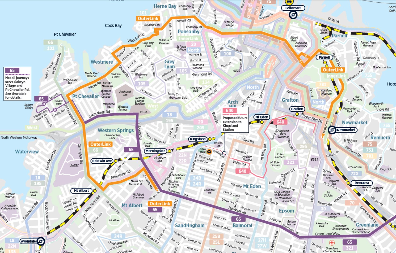
Fixing the Outer Link – closes 13 December
The Outer Link is one of the most recognisable routes but it is also one of the most unreliable due to it being a loop. This often results in long frustrating pauses in places like Victoria Park. Auckland Transport are looking at fixing the route by breaking it up. The busiest section, the parts through inner west, would be retained as is and the crosstown function handled by a more frequent 650 service, to be renamed the 65.
In addition there is a new 640 service that will be created which is in large part to help deal with some of the disruption that will be caused by the Mt Eden Station being closed for CRL works.
As with any change to bus routes there will be some people who benefit and some who are impacted by the changes. Overall many more people will see benefits from the changes, which are well overdue so we support them.
SUBMIT HERE
Bus Priority to support CRL works – closes 10 December
The main works for the City Rail Link are just getting underway. These will see the tunnel and stations built from Mt Eden to Wyndham St, where the initial works have ended. From March the most disruptive phase of the works kicks off and will see the Wellesley St / Albert St intersection will close to all vehicles for 9-months. Once that reopens, the Victoria St intersection will close for 18 months.
Wellesley St is one of the busiest bus corridors in the city and so to help keep buses moving during this time Auckland Transport are looking a adding a number of bus priority lanes, primarily to Queen St, Mayoral Dr and Victoria St.

SUBMIT HERE
Point Chevalier Improvements – 20 December
Auckland Transport are consulting on their plans to improve the Pt Chev streetscape, including building a protected cycleway from Gt North Rd to Meola Rd and then up to Westmere. Our good friends over at Bike Auckland have put together some excellent information on the project and some feedback suggestions.

Impression of Meola Rd
SUBMIT HERE
Sale / Wellesley St Intersection – 8 December
Auckland Transport are looking at signalising the Sale St and Wellesley St intersection. This will make it much easier to cross, both Wellesley St and the gaping maw that was the Sale St intersection – until the council’s design office put some temporary fixes in place.
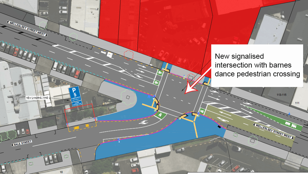
These changes are need but the biggest issue with this is that AT aren’t putting bus lanes on what is one of the busiest corridors which can result in buses taking a long time to travel through this section and on Halsey St. Something to mention in the feedback.
today it took the NX2 20mins to travel 2kms along Wellesley and Halsey St. I should have walked and caught NX at Vic Park.
— Tim Sin (@realtimsin) December 3, 2019
SUBMIT HERE
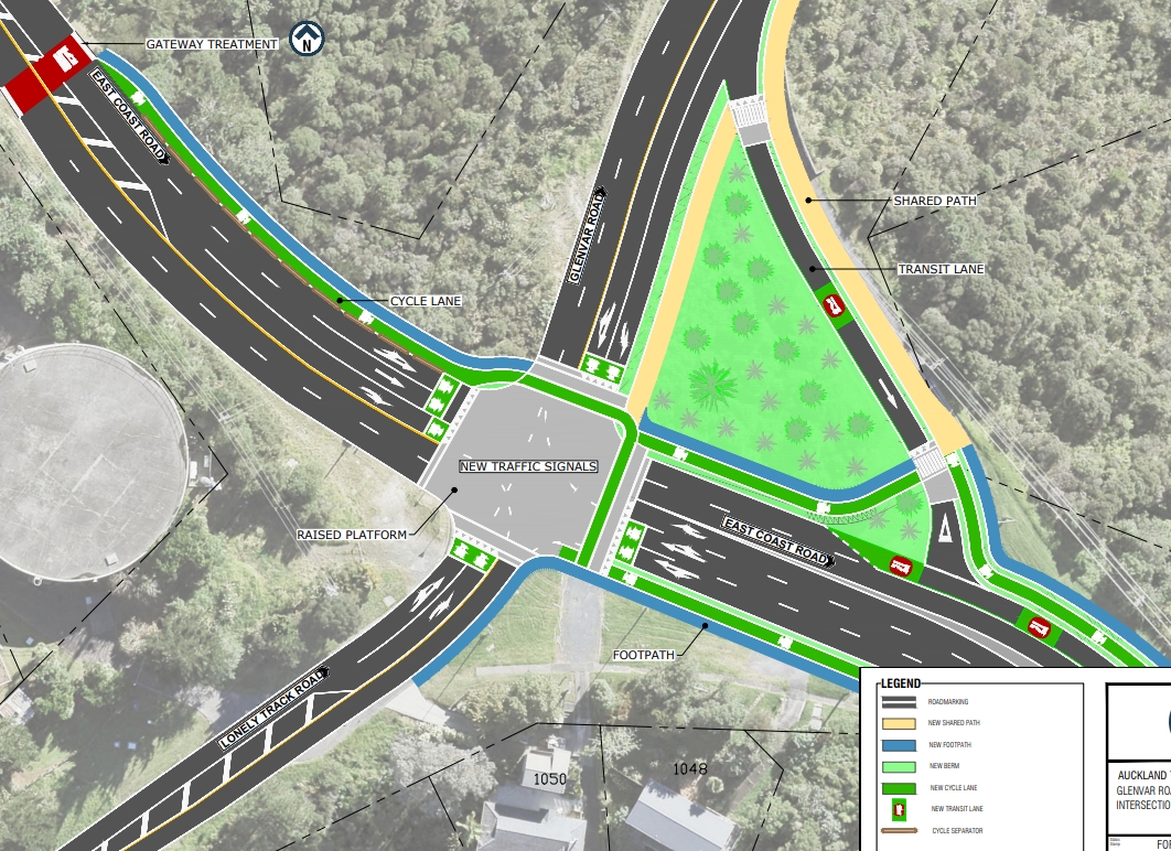
Glenvar Rd and East Coast Rd improvements – Closes 8 December
AT want to make walking, cycling and safety improvements to parts of Glenvar and East Coast Road, including some protected cycleways through intersections. Overall the improvements look good and you can read Bike Auckland’s take on it here too.

SUBMIT HERE
Te Whau Pathway – closes 12 December
Te Whau Pathway is 15km walking and cycling link between the Manukau and Waitemata Harbours mostly following the Whau river. Once fully completed the pathway is expected to connect 33 reserves, esplanade strips, sports parks, and roads along its route. About 2.9km has already be built in some reserves but much remains to be done, including about 7km of boardwalk.
A resource consent for the rest of the project is currently out for submission and should be supported. Again, our friends over at Bike Auckland have more details about the project.

SUBMIT HERE
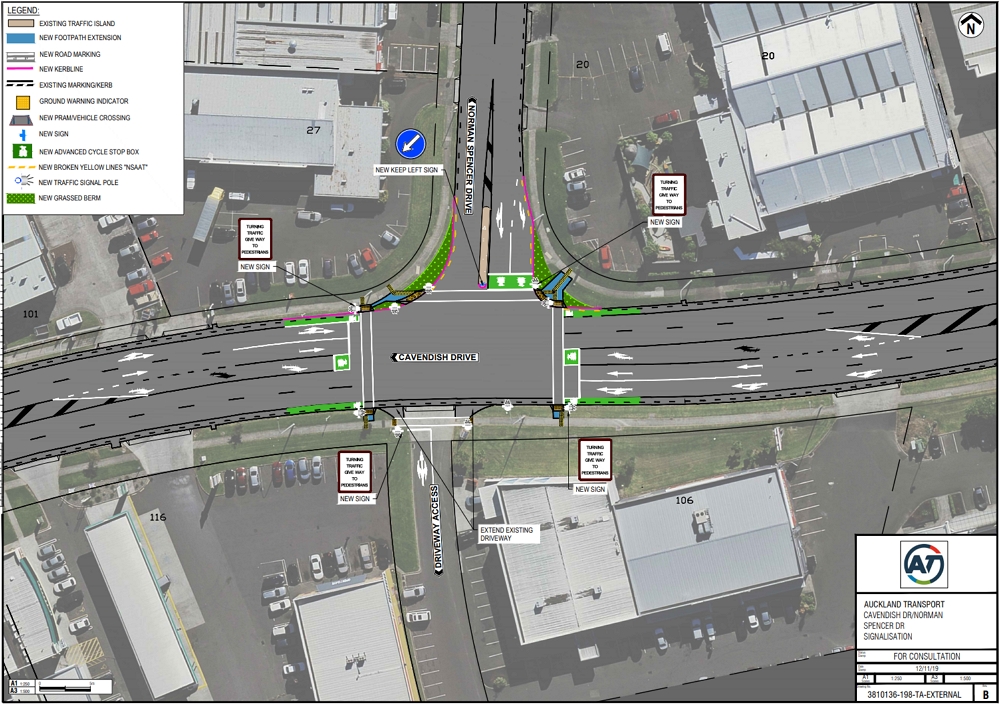
Cavendish Dr and Norman Spencer Dr Intersection – closes 17 December
AT are proposing to signalise this intersection
SUBMIT HERE
That should keep you all busy for a while.

 Processing...
That Cavendish Drive one came out of nowhere
Right to the submission machine!
Te Whau Pathway looks great. Hopefully in the future they’ll do something similar in Otahuhu (using the other Portage Rd). There are already a lot of small walkways in the area just waiting to be connected.
Yes Te Whau will be awesome- whilst it will have obvious great recreational, cultural and environmental benefits I actually think the transport benefits will be massive. Providing short bike ride access to Te Atatu Interchange ( when built) and existing New Lynn station for a huge number of Westies.
“Having so many important consultations all due at about the same busy time” – its a bit sad if 8 mostly minor projects is considered busy for an organisation with the budget and staff levels that AT has.
Where is all that fuel tax going? I was kind of expecting them to do something with it by now…
The link to Bike Auckland (for the Point Chev improvements) takes you to the AT website. I think this is the hyperlink that you intended: https://www.bikeauckland.org.nz/healthy-streets-pt-chev-streetscape/
Thanks. Will amend.
The cynic in me thinks a closing date of 20 Dec for the Pt Chev to Westmere Cycleway is designed to have as little feedback as possible (not helped by 3 sessions at unhelpful times crammed into a small corner of the library)
I just hope people who respond based on Bike Auckland’s post are locals! Last time 2/3 of respondents were NOT from Pt Chev or Westmere which skews any feedback, particularly given Bike Auckland also submit and have been part of the design team.
For me there are some good things about the cycleway and I support having one at least on Meola but it is clear it is designed by cyclists for cyclists to go as fast as possible with little thought to the vast majority of users. For example, while the raised crossings on the side streets and raised non-controlled zebra crossings are great, the designs need to make cyclists slow down at each crossing. They also need to allow space between the crossing and main roads for a vehicle. Is there really a need for a 3m cycle racetrack on Meola? Yes make it 3m where there is space offroad. Wouldn’t be better to use the width to have a bus (+ moped / motorcycle) lane city bound in the morning for at least the central part? Then some parking can be retained for the dog park.
In the end, people will avoid Pt Chev Road and just use all the side streets more that they do now. But at least MAWMILs won’t have to slow down.
The cynic in you should have spotted that the design team were squeezed by AT’s ‘reprioritisation’ work which didn’t allow the project to start again until quite late in the year, and the deadline for getting the funding as part of the larger project from NZTA. When the CLG recommenced immediately after the election, the design team said they wanted to get the consultation finished by early December. It was tight, but putting it into the new year meant finishing the project in time for the funding was put in jeopardy. Complications meant they didn’t make early December (possibly because they listened to the CLG on some aspects that seemed unsafe, and they have made changes), hence it’s later in December. But they’ve been putting in extra effort to engage, listening to locals’ thoughts about how to engage with the businesses, the schools, the general residents.
The previous design was improved substantially after feedback, and some of the features that allowed the retention of the pohutukawas were allowed simply because they had the potential to slow the fast cyclists down.
I worked hard to get both narrower traffic lanes and horizontal deflection to make slower speeds more intuitive for drivers. I didn’t succeed. I take it you’d support me on that? Or are you only concerned about the speed of the very light bikes, not of the massive and potentially lethal motor vehicles?
The designs do make cyclists slow down at each crossing. There are deviations, and there is the fact that they’re about to take their lives into their hands crossing a road. The change in the system needed was to slow cars down, and the raised crossings and entrances will help with that.
This is a design that we can be enthusiastic about, Stu. It’ll improve the suburb, making things safe for children and elderly to get around walking and cycling.
Thanks for the explanation of the timing Heidi. Most of us don’t have the time (or inclination) to look at the causes of delays – luckily we have GA folk to do that for us.
I agree the design is an improvement on last time and thanks for your effort as a fellow local. As I said I am happy with the raised side road entrances and uncontrolled zebra crossings including adding the extra ones and supported that in my last submission – and yes I think they should be on the south side of Meola too. Hopefully they won’t be too steep like the new one on Sandringham Rd though.
I agree that measures to both slow down traffic and hopefully convince some people (and Google maps) that Pt Chev/Meola etc is not the best route to town / north shore are needed.
But some parts of the design are simply designed to cause congestion or remove facilities with no benefit to any users e.g. floating bus stops (except where there is no choice like the start and end part of Meola), raised crossings where there are already traffic lights, no parking in most of bus lane when the lane not in use, removal of all parking on Meola including in areas where the cycle lane is not using any of the current road surface – yes there is a plan to have a new park for the football field traffic which is great if it actually happens, but no use for Meola Reef users.
To me the image that sums it up is the fake one used above. It shows only kids on bikes, no cars or motorbikes or even buses, shows a median strip which is only on that part of the road, shows the trees that will be removed (which I don’t have an issue with) and best of all shows a floating bus stop where there is currently a perfectly good bay which won’t even be affected by the cycle lane installation.
There were lots of improvements that couldn’t get through because it would impact traffic flow. The floating bus stops are apparently the preferred and well-evidenced design, so if you don’t agree with that, you’ll have to ask AT why they prefer it. Obviously they’ll be designing to keep the buses’ timetables as reliable as possible.
I imagine they don’t show vehicles because that might cover the very features they’re trying to illustrate? But yes, a motorbike or distant car could’ve been included.
“no parking in most of bus lane when the lane not in use” – I won’t be silly and assume you mean between buses. 🙂 But I’m not sure what you do mean. There is parking, I thought, outside the bus lane operating hours? (Don’t have time to check right now.)
If you haven’t already, those questions would be good to ask the design team at one of the open days.
The definition of “improvements” in certainly subjective. I suspect your and my definitions will differ.
I did go to the one open day during non-working hours, and spent some time talking to one of the AECOM engineers in the crammed space at the library…
As happens now, when a bus stops at a floating bus stop most cars will just pass the bus creating more danger.
Parking between buses during peak times might require buses to be fitted with mad-max style front ends to clear the cars….
If you get time to check the designs you will see a lot of yellow lines in the proposed bus lane where there is space for parking off peak (mainly sheets 2 and 3 – the yellow on 4 and 5 is for people unfortunate to live on Pt Chev Road to exit)
Yes, I see those yellow lines, thanks. To me it seems it could create the problem that in the interpeak, people will try to use both lanes and then end up slowing the traffic more when they merge, too. I’ll try to find out what the reason is.
Maybe it’s that it’s in such a crucial section of the bus lane, that AT Metro doesn’t want to be beholden to the random practices and ideology of the Enforcement team – during the bus lane hours, people are far more likely to park in designated off-peak parks than on yellow dashed lines. So this could be a consequence of poor compliance and enforcement determining the design for pragmatic reasons.
Some people have been concerned about the bus lane having morning hours as well as evening, but I found this which explains. The morning bus lanes are indeed required as well. I guess it makes sense. Although not a high percentage of people head west in the morning, probably all of those that do from Pt Chev, Grey Lynn, Herne Bay, Westmere, etc, will do so on this route rather than getting mixed up in the areas around motorway interchanges.
https://at.govt.nz/media/1981607/pt-chev-cyle-way-and-bus-priority.pdf
Heidi,
The other reason for having counter flow bus lanes is to ensure a reliable return of buses to start their journeys in the peak direction.
True, thanks Don. And users have often expressed frustration with different bus lanes having different hours, so in general I’d support standardisation.
Heidi. I came across that issue of people using the bus lane off peak as a traffic lane last week. Yes it creates unnecessary congestion so meets one of ATs goals.
The reasons for the limited parking is they are providing some parking for businesses but actively not for any residents – yes I know you agree with that stance but most don’t, hence the area with no businesses having no parking.
I do think you have fallen for the Briscoes marketing ploy with the bus travel time “fact” sheet comparing a worst case time (RRP) with the best (sale price). I regularly drive down Pt Chev Rd in the morning peak and the only occasional delay is from Tui to GNR. I suspect the times given includes picking up / dropping off passengers – sort of a key function of buses. I am surprised that the afternoon delay is not more, but that is only from observation driving the other way. So yes I support having a bus lane but only afternoon peak and probably a bit shorter.
I think there is more of a case for a morning only city bound bus lane down Meola (only really possible in central part) as it takes between 5 and 8 min in morning now from Walford / Moa to Garnet. This could be trialed today by making no-parking on the south side. Then with final design, make lanes the correct width. This might mean the cycle lane is 2.5m vs 3m a short part.
“I do think you have fallen for the Briscoes marketing ploy with the bus travel time “fact” sheet comparing a worst case time (RRP) with the best (sale price). I regularly drive down Pt Chev Rd in the morning peak and the only occasional delay is from Tui to GNR. I suspect the times given includes picking up / dropping off passengers – sort of a key function of buses”
Did you even look at the fact sheet? That is clearly not what they have done.
Yes I did read it and I stand by my comment. They highlight a worst case scenario to use as the headline sales figure. There is no mention of whether time excludes pick/up drop off. And as someone who uses the road all the time and lives in the area, my real experience is that AM traffic on Pt Chev Rd is not congested hence my suspicions re the data.
A bit like the parking study where they say only 10 cars will be affected by removing the 97 parks on west Meola. A quick count yesterday and there were 21 cars parked on that stretch and looked less than normal.
The thing about the parking numbers, Stu, is I imagine they haven’t redone them for this second design. I’ve been counting and there are more than 10 over a day, certainly, even if there aren’t at any particular time. But there weren’t, as recently as 2 years ago. The reason there are more now is because AT aren’t enforcing the Road User Rule parking rules because they misunderstand them. It’s been in the last 2 years that this has flared up, with AT actually saying that it’s not illegal to do so. So people who would not have parked fully on the road itself, thinking their car is likely to get dinged, have started to park on the verge. This isn’t natural; it’s induced parking from the lack of enforcement.
On the bus stats, they give an average. I have no reason to doubt it. Because of the phasing at the lights to suit the peak direction, the counter peak flow is held up – so the options are a bus lane or changing the phasing to prevent that.
I’m planning to go crazy on Saturday to submit on all these and some others if they exist. Even to say yes they are an improvement on the stays quo if with a none thorough look they seem better for safety, public transport, cycling & other active modes. Better to support than be silent or have those against any change win the battle.
Here’s what I said in my response to the Outer Link / 65 bus consultation (referring to a problem already noted by Matt in the earlier article “AT looking to finally fix the Outer Link”):
PROBLEM: The new proposal means that eastbound passengers on the Western line can’t easily connect to an eastbound crosstown bus service. In the past, I could transfer from the Western line to the Outer Link to take me to, say, Balmoral or Greenlane. With this section of the Outer Link removed, such a transfer becomes difficult or more circuitous.
SOLUTION: The 65 bus should make a slight detour to intersect with a train station on the Western Line. For example, it would be easy to intersect with Baldwin Ave station if the 65 bus goes down Wairere Ave and Asquith Ave. This slight detour wouldn’t cause the bus to miss any existing bus stops, though new bus stops would have to be constructed near Baldwin Ave station (but note that buses used to run down Wairere Ave under the old network, so there is existing precedent for bus stops here).
LARGER VISION: AT should realise two things: (1) The trains are now the backbone of the Auckland transport system. It’s a fundamental failure if a high frequency bus route fails to intersect with train stations nearby. One analogy is the 782 route, which was changed slightly to intersect with Meadowbank train station; this was a good idea. It’s even more important to tweak the 65 bus route to intersect with Baldwin Ave or Morningside train station, given that this is now going to be a high-frequency route. (2) Balmoral is a real town centre nowadays, and the ability to make connections to get to Balmoral are increasingly important.
______
What do y’all think about my proposed solution? I guess one issue would be that, with a detour to Baldwin Ave station, the bus has to go over the level crossing at Asquith Ave, which might be dangerous? But surely buses have to drive over level crossings all the time?
I’d wondered about sending it to Morningside for similar reasons… not sure if I’ve got a handle on all the implications (and am in Christmas rush so can’t even think at the moment) but you’re right that a frequent bus should connect with the train.
Oh sorry my reply in the wrong place below, but also that 640 future extension, where on earth can they turn that? I guess have to be a big Sandringham, Onslow, Dominion Rd loop. Do they keep Walters Rd open during a big match at Eden Park?
I think those two streets look like a lot quieter kind of residential streets compared to New North Rd, St Lukes road etc. Morningside Station via Morningside Dr, New North Rd would be a better option if you ask me though a sharp dog leg it also gets you closer to the Station.
The Mt Albert Grammar lads could still access the 65 at that corner & the 65 still intersects with the Outerlink just. Problem is turning the 65 right across one straight ahead traffic lane into Morningside Dr? Perhaps this could be controlled with a special light phasing or something.
Deadline coming up tomorrow the 10th 5pm for the “Bus Priority to support CRL works” project.
I managed to very quickly do the ones due Sunday, didn’t expect the 5pm deadline for one of them so had 5 mins. I suspect it’s kept open a bit after that anyway, but didn’t want to chance it.
On a related note, the CRLL website has just updated today this page:
https://www.cityraillink.co.nz/notifications-construction-albert-st-customs-to-victoria-1 their other works update info looks very well done, included brochures you can download.
Took me a while to click that “Wellesley St / Albert St intersection will close to all vehicles for 9-months.” means totally to all vehicles as it states. Hence all the buses will route up around Queen, Mayoral, Cook, Hobson/Nelson. Oh and Queen/Victoria I guess as well. Their map (in this post) showing existing bus lanes on Wellesley St isn’t quite correct as their is a couple little bits already in some spots as I see it. eg East bound both on Wellesley between Nelson & Hobson & tiny bit between Queen & Lorne St.
Reading through their page it’s good to see:
“It is envisaged that, once these changes are in place, bus travel times will improve in line with Council’s long-term vision for the City Centre.”
Here’s another Consultation that’s important:
Region-wide zebra crossing improvements
https://at.govt.nz/projects-roadworks/region-wide-zebra-crossing-improvements-2020/
Looks like the extended the deadline for the Central crosstown bus changes:
Project status: Consultation – open until Monday 23 December 2019.
There is also a nice new schematic map of the proposed changes on that webpage:
https://at.govt.nz/projects-roadworks/central-crosstown-bus-changes/
Pt Chev consultation feedback page still seems open for any more last minute support.