A few weeks ago we learnt that Waka Kotahi NZTA were due to release a new business case for a harbour crossing and that it would recommend first enhancing the Northern Busway and then looking at a public transport crossing ahead of any new road crossing. The business case is now available and there’s quite a bit of interesting information in it.
Firstly, let’s just look at some of the numbers and issues.
They say the North Shore currently home to about 337,000 people and that by 2048 that is expected to increase to 497,000, a 160,000 or 48% increase. Of that, around 103,000 people are expected to expected in sprawl greenfield growth north of Albany. Of the remaining growth, most of it is expected in three areas, Albany, Takapuna and Northcote.
It is also expected that job growth on the Shore will not match population growth and mean there will be a lot more travel demand in the future with the city centre and fringe being key destinations for work and education trips. On the Shore, Takapuna and Smales Farm are expected to become the most significant employment zone while industrial areas like Wairau and Rosedale are not expected to see much growth.
The report says the Harbour Bridge “is the most travelled route in New Zealand“, moving around 235,000 people a day – 171,000 vehicles a day (205k people at an assumed occupancy of 1.2) and 30,000 PT trips. However SH1 just south of the city between Gillies Ave and Khyber Pass carries over 201k vehicles a day or about 240k people.
The graphs below show traffic flows and capacity of the bridge throughout the day now and forecast in 2048 – although models are frequently wrong and the southbound one seems to have an error as surely the AM peak should have nearly 9k capacity like northbound in the PM peak.

Despite modelling things in 2048, the report notes that:
Due to the wider network capacity constraints on the road network, public transport needs to accommodate all peak direction, peak time additional cross-harbour travel in the future. This scale of demand growth means the Northern Busway (including its stations and key city centre bus routes) will become overwhelmed in the future, with the additional buses needed to meet demand placing pressure on stations and city centre streets, ultimately resulting in longer and less reliable trips.
This trend has already been happening for the city centre as highlighted in this graph – though this is not just from the shore but all city centre trips

The scale of the growth means that even with busway enhancements enabling 110 double-decker buses an hour, the buswa will hit it’s effective AM peak capacity in the early 2030’s.
The report also talks up the importance of the bridge to moving goods and highlights the growth of Heavy Commercial Vehicles, particularly in recent years. What the authors seem to have not realised though, and something we’ve confirmed with Waka Kotahi in the past, is that double-decker buses count as HCV’s and they were first introduced to the network in 2013 so it’s quite possible a big chunk of the increase is actually the result of the growth in PT.

There’s much more detail and background information in the report but let’s move on to the more exciting stuff.
As mentioned at the start, the report confirms the priority is to first enhance the busway, then to add another rapid transit connection and lastly to add road crossing. Let’s look at these
Busway Enhancement
At an estimated $500-600 million it’s easily the cheapest of the options but also the recommendation that stands out the most to me. That’s because the original 6km of busway and about 2.3km of southbound bus lane along with the five original stations cost just under $300 million while the currently under construction 4km busway extension and the Rosedale station will likely have a similar cost. This shows that the envisioned enhancements are much more substantial than I had previously imagined.
Looking at the options we can see why. It would essentially build a busway spur to Takapuna, fully extend the busway to the base of the bridge including an Onewa Station and include improvements in the city centre. These improvements are expected to increase the capacity of the existing busway by about 30%. Of note, the do minimum changes include a 50% increase in bus frequency all across the North Shore.

There is also a separate version of the busway enhancements map that doesn’t include the Takapuna Spur or Onewa station so it’s not clear if those will still be in the programme.
They also investigated a separate ‘Advanced Busway’ which would have taken things a step further and seen high-capacity articulated buses capable of carrying 170 people and included full bus priority on the bridge.
Rail Crossing
The initial part of the report looks at a range of PT options, including the enhanced and advanced busways mentioned above. Three of these are shown below


The third one is interesting as it lines up with options we’ve talked about before and would enable a full light metro line from Albany to the Airport. This could of course be staged over time. What’s also notable is that while it about doubles the cost of Option 4, it’s still cheaper than the heavy rail option which would only be just for the connection from the city to Albany.
However, the report says that even if the busway was converted to light rail, about a 40% increase on the enhancements above to about 14,000 people an hour, it still wouldn’t have enough long-term capacity. As such, it seems they’re looking at this new crossing as potentially being independent of the busway and meaning we could end up with two separate rapid transit lines parallel to each other, which would mean lots of capacity but doesn’t really expand the reach of the RTN network other than possibly a station at Takapuna.
Something doesn’t quite add up here though as some light metro style options overseas are capable of moving 25k-30k people an hour suggesting the authors are not modelling things correctly, perhaps assuming services run less frequent than is possible.
The report there has an additional rapid transit assessment and below are some of the questions about it they’re trying to answer:

This extra study looks at three options, effectively light rail, light metro and heavy rail. The main difference to the initial options seems to be that it would initially only go from Smales farm to the city until it is decided how to get it further north, but would include a diversion to Takapuna.
It doesn’t actually state a preference for any mode and notes that there “is little difference in attractiveness between light and heavy rail“. The decision on which mode to use is really going to depend on the wider plans for rapid transit in Auckland. Part of the next phase of work is look more closely at both the mode and timing questions. The summary suggests this crossing could cost $6-7 billion however the report also notes that a bridge option could be only $2-3 billion and have lower operational costs. All options would have greater costs to get the connection north of Smales Farm.
Road Crossing
The engineers can’t bear to not include a road crossing so it’s still in the plans. They’ve looked at three options with costs of $1 billion, $2 billion and $10 billion.


Options 2 and 3 are what they’re looking at more closely but at least at this stage and despite only adding two lanes, the $2 billion option seems to perform fairly well compared to the $10 billion option. It also appears to be considered more feasible and has a better benefit to cost ratio – though both are terrible at 0.3 and 0.2 respectively.
There is also a quick analysis of the benefits and challenges of separate or combined crossings. The short answer is they say “separate tunnels are preferred at this time“.
Overall, given how long this has been worked on, I’m surprised by how high-level it all is. The report is useful but seems to ask more questions than it answers. Hopefully we will learn more from the next steps – as shown below:


 Processing...
I’m glad they included the road crossings in the report. It highlights again how bad they are.
The engineers only need look at Sydney for inspiration on how many people a light metro line can move through a point. Sydney metro will be able with a few smallish future upgrades to move 46000 people an hour per direction on 8 car trains and 2 minute headway’s. Does it get any higher capacity than that? Crossrail is a similar capacity with 1500 person trains on 5 minute headway’s although there may be future upgrades they can make too. That’s the premier heavy rail route of today.
Agreed that the road options don’t look flash, but the BCRs for the rail / light rail options are pretty terrible as well at 0.14 to 0.19. I couldn’t see them in the main report – instead they’re hidden away in Appendix H.
Interesting. It really sounds like the busway is going to have a decently long life ahead of it then. Sure, it might get congested, but that never put anyone off driving. And it will always be faster than driving.
Theres lots of cheaper bandaid solutions to extend the capacity of the busway as well anyway.
Option 6 looks good, only if they commit to building to Newmarket and then leave the rest for later, otherwise the cost will surely be astronomic. Imagine if we could get building on this in 5 years….
Looking at the map, they should be looking for a second RTN line, which would have to be underground by definition, that snakes north by a western corridor through Birkenhead/Northcote/Glenfield
I agree that Birkenhead looks pretty desolate, but I’m not sure that it will get a north south rtn line. At the very least the Onewa station is needed, and a few east west decent bus lanes / routes. I work in Takapuna and a lot of my collogues live in Birkenhead area. They say that the quickest / most reliable way to get to Takapuna is to go over the bridge to the city and change to the 82 at Victoria park. Which is insane.
Cut and cover down Manukau Road? What are the costs for Albert Street?
Where does it say cut and cover?
I’m asking because a tunnel from Newmarket to Onehunga seems very expensive. A cut and cover trench could be an alternative.
On second reflection, extending the tunnel to Mangere would remove the need for a third crossing.
Cut and cover costs more than bored tunnels over any significant distance.
Albert St had to be cut and cover because it was a short, shallow section of tunnel on a steep grade and with a tight radius turn at one end.
It would be better to bore a tunnel down Manukau Rd as it would be less disruptive, faster and cheaper. It could be done without relocating services and would be able to go under private property in places (say between Royal Oak Roundabout and Onehunga) without property acquisition.
The cheapest way to do Option 6 would be to bore a single tunnel as a series of linked drives using the same TBM. This could still be staged over a number of years but would avoid the massive costs incurred each time you have to start a megaproject from scratch.
Wouldn’t the basalt make that too difficult? It is 30 to 40 m thick in seem places, I have drilled it before, you could tunnel beneath it but a cut and cover would be impossible without lots of explosives. Doubt it you get that consented
About the difference in peak capacity north/southbound on the current bridge: perhaps it is due to the approach lanes. E.g. at peak, northbound has 5 full approach lanes, vs I think southbound has only 4 full lanes plus the bus lane, until a fifth central lane is added just before the bridge, with no on ramp to fill it.
If that’s the case it just further confirms that the capacity constraint is not the bridge but the approach.
The main constraint is never the lane, it is almost always intersection or the station.
Yes I think that’s the main difference plus trying to “poke” all the cars into the parking spots at the city end is probably going to back things up more than the dispersion north over a wider & longer area of off-ramps and parking facilities (ie mainly peoples homes). I’m just guessing here but in the morning southbound commute would be worse than it appears too due to longer a “peak period” ie early starters etc compared to most leaving work in the city more at the same time?
For $10billion you could probably reroute the harbour.
For $10 billion they could build 20,000 apartments on the right side of the harbour and give them away for free.
For $10 billion they could house 160,000 on the south side of the harbour, including in the walkable, connected, healthy neighbourhoods people want to live in.
However would you have the sewer capacity to accommodate the high rise apartments or medium rise for that matter.
Think it through to the next generations, Royce. If it’s too expensive to replace and upgrade the sewer pipes in existing areas for this extra capacity, which need replacement and upgrading anyway, how on earth will the next generations afford to replace and upgrade the sewer pipes in an ever-expanding city?
Less overall infrastructure means lower outgoings on a continued basis.
It is this upgrading – of pipes and streetscapes and public transport – that the money should be going to. Government investment in the actual housing will cost in the short term but not in the medium or long term, as property development should make money, or at least make ends meet if affordability is the aim.
Moot point, we don’t have the sewer capacity for 100,000 extra people north of Albany either.
For $10 billion you could subsidise a million EVs; build the extra lines and possibly the extra renewable power infrastructure. Unfortunately our roads would be even more congested; buses would be stuck in general traffic and we still wouldn’t have any more bike lanes. This seems to be the preferred option.
New hydro dam across from Devonport to Kelly Tarltons?
🙂 Or a dyke to ward off rising sea levels?
Think of all the land that we could reclaim for housing close to the city instead of building it on the fringes
that’s one powerful dyke!
I think it is called a barrage. It would be green energy, except it would affect the fish, molluscs, birds and wealthy boat owners (anus navi).
The various plans we were asked to submit on called for a compact city development strategy. It was all a rort. We’re getting sprawl on steroids.
And these AWHC projects are yet more billions of dollars to support this sprawl.
Yes, 103,000 of those 160,000 new people projected to live on the North Shore will be housed in sprawl north of Albany. A further 16,000 are projected to be housed in sprawl in Albany itself. That leaves only 46,000 actual brownfields development, or 29%.
There are two possible development strategies that would sustainably house these new residents instead:
1/ within the isthmus – yes, it’s possible, and will take government investment.
2/ within mixed use nodes on the north shore.
This latter one will create more jobs on the shore, but not just jobs: it will house services, cultural amenities, children’s after school activities and so on, that allow 15 minute city lifestyles for many people, allowing massive modeshift and cutting down the pressure on the road network.
Either of these will reduce pressure on the harbour bridge enough so that road reallocation of the bridge to buses, and eventually, to light rail, will accommodate the growth. For the latter one – maybe not forever, but for long enough for us to know whether an AWHC is really what we should be spending our money on.
This madness has to stop. It’s impoverishing our children – not just with having to pay off projects like this, but having to cope with and pay to maintain an ever-more-sprawling city.
Well said!! Suburban sprawl is the root cause of congestion in Auckland (and most new-world cities). We need to increase density to reduce commute distances.
All of the tunnel options that skirt past Bayswater…. if they’re going to do that then add a bloody station at Bayswater to allow higher density there. It is located (as the crow flies) so close to the city yet by road it is much further in traffic etc.
This would also help solve the Lake Road/Devonport problem.
Converting Bayswater from low density into medium/high density could be about double or triple what Hobsonville Point is going to be while being much closer to the city!
A station at Hauraki Corner probably makes sense but the Bayswater peninsular is probably a bit small to justify the cost.
Peninsula. Not peninsular!
Yes quite. Typing quickly from my phone
Yes of course, but that would involve a longer route and more cost.
The plans above show going via the end of the peninsula but without a station.
The peninsula is the same size as Hobsonville Point which is going to have 11,000+ new residents when completed.
Hobsonville Point is however nearly at the edge of Auckland’s urban area so isn’t suited to high density – which is why it’s only medium density.
Bayswater on the other hand could be completely redeveloped (albeit likely with some sort of government compulsory acquisition) and could house 3x that number (or more). Build the whole thing out at 5-7 levels like Europe then with a rail link to both the city and Takapuna (and the rest of the Shore) would be amazing. We’re talking the current CBD resident population by the way.
They’re absolutely not the same size. The peninsula, as shown in red is about 0.54 sq km while Hobsonville is about 3.26 sq km. That’s not to say you couldn’t get 11k people on that spot but is unlikely. Hauraki, shown in blue, is on the way and easy area around it is about 1.45 sq km, so nearly 3x the size, and would also serve to intercept trips along Lake Rd.
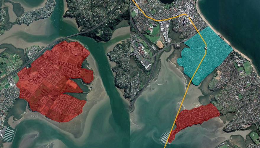
Bayswater taking 11,000 people per 0.54 sq km gives a density of about 200 ppl / ha which is half the density of the 30 most dense neighbourhoods in Barcelona – the ones NZers love to visit because they’re so vibrant and full of life. It is achievable, and you’d definitely need RT to its doorstep.
In Hauraki, housing that many people would only require a density of 76 ppl /ha, relative countryside. 🙂 There are big advantages to having the station in the middle of the area and of having the resilience of two transport corridors – (one day Lake Rd will be allowed to become efficient).
But it is also achievable in other parts of Auckland where providing RT on its doorstep doesn’t cost billions. Any one of these solutions shows that we simply do not need the sprawl.
But Labour seem set on it, with their fast-tracking the ‘foam factory’ in Huntly.
@Matt, so you include Scott’s Point etc which more than doubles the size of Hobsonville Point (its its own development btw) while only including half of Bayswater peninsula? Bayswater goes all the way to Lake Road (Belmont).
So as Heidi pointed out the density needed isn’t even that high and that’s with your smaller area so with the bigger area all good.
@AKLDUDE
What matters is the potential catchment of proposed station, not some arbitrary suburb boundary. At the end of Bayswater most of would be harbour, whereas a station at Hauraki would be surrounded by land.
Yes, it’s the problem of wharf walk-up catchments unnecessarily applied to a rail station. The Hauraki location would be much better.
@GK, I’d love for the station to be located closer to Hauraki/Belmont but imagine it would be quite costly to achieve.
Even at the end of the peninsula if redeveloped right isn’t a problem. Firstly it’s flat and straight to get there. Easy to operate a bus loop to service that area to the station (just as in most cities around the world do).
My point is that rather than no station anywhere South of Takapuna, we could easily have one in Bayswater and redevelop an entire suburb that is very close to city.
So why not tunnel to Onewa station, causeway and low level bridge to Bayswater, then tunnel via Bayswater and Lake Roads to Takapuna, linking to Smales farm. Causeway could utilize tunnel spoil and be wide enough to include a cycle/path to Bayswater? There is a lot of tunnel spoil to be removed that could be used. May go some way to address Lake Road congestion?
Lake Road congestion has a solution, unfortunately that some of the councilors don’t like. It also doesn’t involve a big zig zag or an extra billion dollars, and has a chance of getting resource consents which a causeway to Bayswater wouldn’t get.
The environmental effects of all these options aren’t really something we should be considering.
So you’re arguing for no cross harbor railway even?
I’m wanting to see some analysis of a proper compact city development plan before I make my mind up.
No Onewa rail connection seems a bit of a miss, particularly when a busway station is being developed. Passengers could just as easily transfer to rail, even if the station was below sea level.
Would there be any potential to include a Northwestern line into a Option 6-style light metro network – e.g. running the line through the CMJ and joining up with the North Shore-Airport line at the Hospital or under the universities before running to the Takapuna spur?
I’m rather partial to the 2-line operating pattern from the CFN 2.0.
Whatr is the point of a rail crossing? At have given up even pretending they have a train timetable and have taken them down from their website.I went from Morningside to Ellerslie last Frida, with delays and waiting and creeping through Mt. Eden it took 55 minutes to travel 7km as the crow flies.
Instead of a reliable service you have to go and check the disruptions page to see if you can get to work that day. It is the very opposite of reliable and it sure as hell isn’t cheap. Unreliable, disrupted and expensive – what a joke.
The network is a shambles run by incompetents. There won’t be anyone left on the trains by the time the CRL is finished.
A light rail or light metro network would be completely separate from the heavy rail network, and thus not affected by anything going on with heavy rail services.
Double-decker capacity on the Northern Busway will not be sufficient after the 2030s. Rail is the next step up in capacity – at least double or triple that of buses.
Issues with the current train network is not indicative of the future network. I dont see how Auckland is so special in peoples eyes that we cant make systems that work fine overseas work here.
AT is increasingly being run by recent Uni grads who now work at Deloittes and PWC. They get hired at hundreds of dollars per hour, to run “innovation sprints” that consume a vast amount of time and that identify the obvious.
ie: “When the trains aren’t running, there should be replacement buses.”
No kidding.
I’m not quite sure how they figured out that heavy rail has a higher capacity than light metro or where they got a light metro capacity of 25-30,000 people per hour from. They even mentioned Skytrain as an example of light metro, which has vehicles that can carry 700 people and operate frequencies as high as 45 seconds.
If we are building the line specificaly to increase capacity, we could build stations to accept trains that can take 1,000 people and run them every minute. Then we wouldn’t need to build the new light rail line on top of the busway as proposed and we could just replace the busway at far lower cost. Of course, we could also just build a quad tracked light rail bridge and then run two lines, which I am quite surprised wasn’t even longlisted.
They don’t say 25-30k. I said that (Vancouver is more like 90 seconds, not 45). They seem to think it will only be capable of just over 14k per hour suggesting they’re modeling only something like 3-4 minute frequencies.
Interestingly they note with 10k per hour Busway and their 14k per hour LR crossing that “24k per hour is more than sufficient for decades ahead” or something to effect
Can we save two years and just agree to build the three rail light rail bridge with pedestrian and cycling promenade that we’re going to end up with anyway, once cost aversion and pragmatism finally prevails? I feel like we are knowingly enduring two years of cost and case studies before we even get to the good stuff for no actual reason, which would probably pay for the fourth rail of a Light Rail bridge or a linear park across the harbour if we so desire.
Don’t be mean, poor NZTA will get sad if you don’t pretend there is a big motorway in it for them.
I wonder what else their modelling showed. They say it shows a slight increase in vkt on the bridge, and we know the SH1 corridor has the highest traffic volumes in the city.
Clearly, to be compatible with the Auckland Climate Plan target of 12% vkt reduction by 2030 and 2050, there’ll need to be quite large vkt reduction elsewhere in the city. I wonder what plans they modelled to achieve that?
OK, tongue out of cheek: they’ve simply ignored the Auckland Climate Plan, the country’s international obligations and the ZCA. And this, despite public support for action on climate.
These decisions have a material impact on our climate response. At some point WK’s approach will be shown up as arrogant misalignment with our country’s climate goals.
All the increased vkt will be by the new 100% electric vehicle fleet of the future, which will solve all known problems. Or so some people believe.
And all the existing vkt too, since we have to decarbonise…
It will be a bridge next to the existing one with more lanes for traffic plus a couple dedicated to public transport. So we might as well get on with it rather than waste time and money on more studies. So Greater Aucklands job should be advocating for a corridor completely separate from traffic right from Queen Street to where it would join up with the existing busway. Presumably the cycling walking path which is going to be built won’t be impacted by a new bridge. In fact make sure that it isn’t can be another job for greater auckland.
Greater Auckland’s job should be advocating to make sure we don’t waste billions of dollars building a road here.
Its backup in case something happens to the existing bridge but its main job is to take buses across the harbour in an uncongested way.
And it political National is never going to let a new harbour crossing be public transport only. And Labour will be too timid to try anything bold.
And any new rail line will just take forever too plan and build. But look at the good side if there could be a completely congestion free busway its a win for public transport if people then still insist in sitting in their jam tins on a congested motorway then good luck to them.
There are enough roads-first people out there saying it has to have a road. Why speak for them when you could instead say straight up that we don’t need a road crossing? There’s power in saying truth, Royce, and if we adopt a defeatist attitude about each project in turn, then we might as well adopt a defeatist attitude about everything.
Option 5, what the heck is that??
They want to snake HR from Takapuna and then to Unsworth Heights and back to Albany…
Was that option drawn up as a joke or is there some reason like the ground conditions aren’t suitable for a TBM elsewhere. I would of thought any rail option would always follow the current busway.
I have always thought a bridge from herne bay to Clelsea bay with good landing height on both sides of the harbour allowing for a bridge with good clearance for boats.
And a TBM run under Ponsonby and from Clelsea bay under Birkenhead to Northcote connecting to the busway with new stations at Northcote Highbury and Ponsonby.
That idea is mad but still nothing in comparison with the madness of option 5.
Heavy rail can’t use the Busway, it would require a full rebuild of every structure and tunnels for the more restrictive grades such as around Constellation. This is stated in the report
It would still be much cheaper to to convert the busway to run any future system like replacing the bridge over Tristram Ave and Wairau Rd and lowering constellation station and raising other sections through sunnynook.
Regardless heavy rail won’t happen on the shore but a nice purpose built light metro that outperforms our current HR network for comfort and speed would still need good track gradient.
Why does light rail have to have its own separate system to run alongside an existing busway. What is wrong with burying the tram tracks into the busway and running the light rail and buses together. Why re-invent the wheel. If the busway has a concrete base, eg the busway between Pakuranga and Panmure, then lay the sleepers on the concrete and bury the whole lot in asphalt, as I think they did for the Wyndham Quarter tramway.
The reason to switch to rail is to increase the capacity. You’re not going to get anywhere near the maximum capacity out of a railway line if there are random buses indispersed between the trains.
If one was going to use light rail why not run it via Devonport?
It would make a longer trip for most users.
You could stage it. And building it so busses could run too would make it so part of the busway could be open during construction still. Like a normal road road works but for busses. Then as you need capacity, remove more and more busses replaced with light rail trains.
This was supposed to be a reply to jezza above
For those not sure what this means for walking & cycling across the Waitemata, I see on page 43-44 of the AWHC Business Case:
“A walking and cycling connection across the harbour between Westhaven and Akoranga (known as the ‘Northern Pathway’) is proposed to be completed by 2024. This facility, once implemented, will provide a connection for walking and cycling between the North Shore and the existing shared path at Westhaven with Northcote Point. This connection will be implemented regardless of the outcome of this business case.”
Oh, that we could trust them on this.
Ridiculous basic assumptions about jobs still being out of the area where people live.
Where is the associated planning to build up Albany or even Silverdale as centres for work and other activities?
Option 5 looks quite attractive. They should focus on rail option and start as soon as possible. Then take care of the bus and road enhancements. I’m sort of worried that they will be starting business cases one after another and won’t get to do anything in the end. Like with the light rail last time
Incredible that they’re still planning population increases.
Heads stuck firmly in sand.
Crazy eh. The population of Auckland has increased pretty much continuously since 1840 and for some reason they think it will continue to increase…
Yeah let’s do another 180 years of that.
If only every person didn’t feel the need to have a car. That is the real problem.
I’m not sure the alternatives are that great, a static ageing population or a shrinking ageing population.
Better than a dead planet.
Tis I – whether Auckland has 1.5m, 3m or 10m in 180 years will have negligible impact on whether the planet is dead.
While it is possible zero growth would be a good outcome, the worse thing the agencies could do is plan for no growth. Auckland at the moment is ironically the best evidence of not planning sufficiently for growth.
That’s like say we’re too small to make any difference to climate change so don’t bother.
There are 8 billion people on the planet and growing . That’s the the real crisis.
Well it’s certainly used as a good excuse by many polluters to not have to change their lifestyles. Often based on an arrogant assumption that the lifestyles they’re leading are somehow currently or historically normal. Neither is true. Many New Zealanders have quite abnormal lifestyles, and sit within the most polluting 1% of the world’s pollution, making them responsible for an enormous part of the polluting burden.
We must simply reduce our individual footprints to what’s sustainable for the population we have, through commitment, experimentation, and advocacy for the systems changes that are necessary.
Anything less is just trying to pass the buck.
Tis I – completely agree the 8 billion and counting population is the real problem, although I’d add to it the consumption of resources by said population.
However, arbitrarily attempting to control the population in one particular jurisdiction or city through failing to plan for growth isn’t going to solve that problem. Reducing consumption of resources in Auckland and the rest of the world is what needs to happen.
“There are 8 billion people on the planet and growing . That’s the the real crisis.”
Yep, and restricting population growth in Auckland will not do anything to solve that issue.
Reducing carbon emissions in Auckland will do nothing either, right?
Auckland, and New Zealand, have a non-replacement birth rate. It’s very important for us to take population from other parts of the world as well as for those other parts to reduce their birth rate.
Same with emissions, if we had the means to sequester other countries emissions we should do that also, as well as them reduce theirs.
The ‘Advanced Busway’ with articulated buses is an interesting idea but I think would really be a bit horrible if they can’t use the whole of the busway. Seems they would just operate from a new Onewa Station (I first misread it as Orewa yesterday skimming through the reports and thought, hey great idea). Surely they could use them if just on the busway stations even if they needed to be modified?
I also think the Option 5, HR option sounds interesting with that different route though expensive sounding. This could just be driverless metro? It has never been proposed by anyone that I have seen and can remember on this blog or otherwise.